Achanakmar-Amarkantak Biosphere Reserve: Maikal Hills, Tri-State, UPSC Notes
Achanakmar-Amarkantak Biosphere Reserve straddles Madhya Pradesh, Chhattisgarh, and Jharkhand on the Maikal range, the source of Narmada, Sone, and Johilla rivers. Full UPSC guide on flora, fauna, tribes, and zonation.
The Maikal range is the geological hinge of peninsular India. It is the spur where the Vindhyas hand off to the Satpuras, where the Deccan trap thins out against the Gondwana sandstones, and where three of central India’s great rivers, the Narmada, the Sone, and the Johilla, take their source from a single high plateau. The plateau is Amarkantak, sacred in the Hindu and Adivasi traditions for centuries, and the surrounding forest and hill country is the Achanakmar-Amarkantak Biosphere Reserve. The reserve was notified in 2005 and inscribed on UNESCO’s World Network of Biosphere Reserves in 2012, becoming the tenth Indian biosphere reserve to receive that international recognition.
The reserve sits on the boundaries of three states: Madhya Pradesh (the Anuppur and Dindori districts on the Amarkantak side), Chhattisgarh (Bilaspur, Mungeli, and Gaurela-Pendra-Marwahi districts on the Achanakmar side), and a small extension into Jharkhand at the eastern fringe. The total area is around 3,835 square kilometres, with the Achanakmar Wildlife Sanctuary (now a Tiger Reserve under Project Tiger from 2009) forming the core. The forests are predominantly tropical moist deciduous, dominated by sal (Shorea robusta) and teak (Tectona grandis), with bamboo brakes and grassland glades through the valleys.
For UPSC, Achanakmar-Amarkantak is a multi-thread topic. It feeds into prelims on UNESCO biosphere reserves, on river sources, on Project Tiger reserves, and on tribal communities. It feeds into mains on landscape conservation, on the Forest Rights Act, on Particularly Vulnerable Tribal Groups, and on the management of multi-state protected areas.
Quick Facts
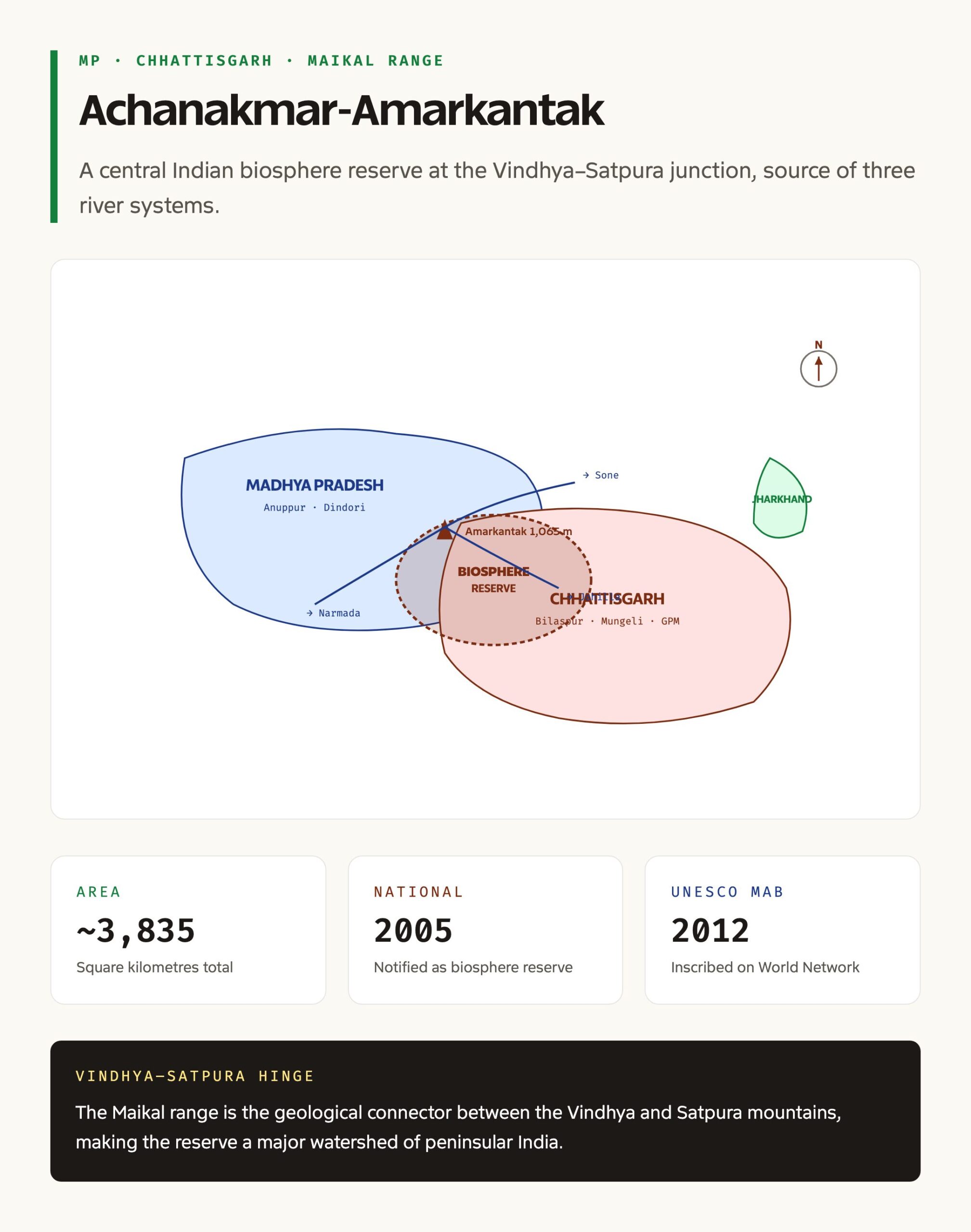
- Notified as biosphere reserve: 2005 (national); 2012 (UNESCO MAB inscription)
- Total area: Approximately 3,835 square kilometres
- Core zone: Achanakmar Wildlife Sanctuary; declared a Tiger Reserve in 2009
- States covered: Madhya Pradesh (Anuppur, Dindori), Chhattisgarh (Bilaspur, Mungeli, Gaurela-Pendra-Marwahi), with a sliver in Jharkhand
- Mountain range: Maikal Hills, the connector between the Vindhya and Satpura ranges
- Major rivers originating: Narmada, Sone, Johilla (all from the Amarkantak plateau); Arpa and Maniari (from the Achanakmar side)
- Forest type: Tropical moist deciduous (Champion-Seth classification)
- Dominant species: Sal, teak, mahua, tendu, bamboo
- Key fauna: Royal Bengal tiger, leopard, Indian bison (gaur), sloth bear, four-horned antelope (chausingha), sarus crane
- Tribal communities: Baiga (PVTG), Gond, Kol, Pradhan, Korwa
- UNESCO MAB year: 2012
- Watershed significance: “Major Watershed” of peninsular India, source of three major river systems
What Is Achanakmar-Amarkantak Biosphere Reserve
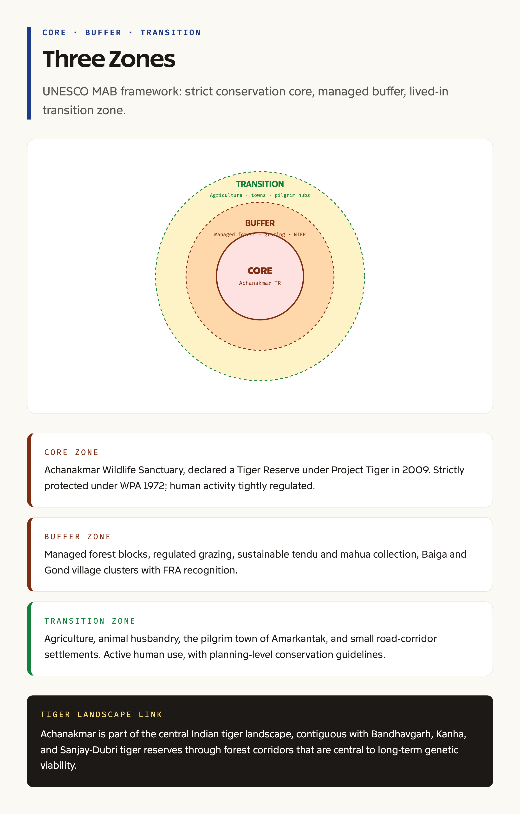
A biosphere reserve in the Indian system is a large landscape-level conservation area that combines a strictly protected core, a managed buffer, and a transition zone where human use continues. The framework is based on the UNESCO Man and the Biosphere (MAB) programme, launched in 1971, which sees biodiversity conservation, sustainable development, and logistical support for research as three integrated functions rather than competing demands.
Achanakmar-Amarkantak fits this template precisely. The core is Achanakmar Wildlife Sanctuary on the Chhattisgarh side, where human activity is strictly regulated and the focus is on undisturbed habitat. The buffer surrounds the core and includes managed forests, regulated grazing, sustainable tendu leaf collection, and Baiga and Gond village clusters with Forest Rights Act recognition. The transition zone extends to the agricultural and small-town landscape on the periphery, including the pilgrimage town of Amarkantak and the small settlements along the Bilaspur-Anuppur road.
The reserve’s biological identity is shaped by three things. First, the Maikal hill range, which gives it elevation and topographic complexity. Second, the Amarkantak plateau, which provides the watershed and the perennial river systems. Third, the moist deciduous sal-teak forest, which provides the structural habitat for a long list of central Indian fauna.
Background and Historical Context
The Amarkantak plateau is one of the oldest sacred sites in the central Indian Hindu and Adivasi tradition. The Narmada, considered a goddess in her own right, takes her source from a small kund in Amarkantak town, and the area has hosted Saiva, Shakta, and tribal pilgrimage for centuries. The forests around have been the home of the Baiga, who are recognised as a Particularly Vulnerable Tribal Group, and the Gond, who form one of India’s largest tribal communities. Pre-colonial governance was through tribal kingdoms and small principalities; the Korba and Bilaspur regions sat within the Baghelkhand and Ratanpur kingdoms before passing through the Marathas to the British.
Geography and Hydrology
The Maikal range runs roughly north-south through the reserve, rising to about 1,050 metres at the Amarkantak plateau and falling to around 350 metres in the lower river valleys. The geology is dominated by Gondwana sandstones and shales, with patches of Deccan trap basalt at higher elevations. The soils are red and yellow lateritic on the slopes, alluvial in the valleys, and rich in organic matter under the sal canopy.
The hydrology is the single most important biophysical feature. The Narmada rises from a small spring at Amarkantak town and flows westward, eventually emptying into the Gulf of Khambhat after 1,312 kilometres. The Sone rises just a few kilometres away, on the same Amarkantak plateau, and flows north-east to join the Ganga near Patna. The Johilla, a tributary of the Sone, also rises here. The Arpa and Maniari, from the Achanakmar side, flow into the Mahanadi system through Chhattisgarh. The reserve therefore feeds three of India’s major drainage systems: the Narmada-Tapti, the Ganga, and the Mahanadi.
This watershed status gives the reserve a hydrological importance that extends well beyond its biological boundaries. Forest cover in the Maikal range maintains the recharge of the headwater streams, and the integrity of the Achanakmar core has direct implications for downstream water supply in Bilaspur, Anuppur, and beyond.
Why It Matters
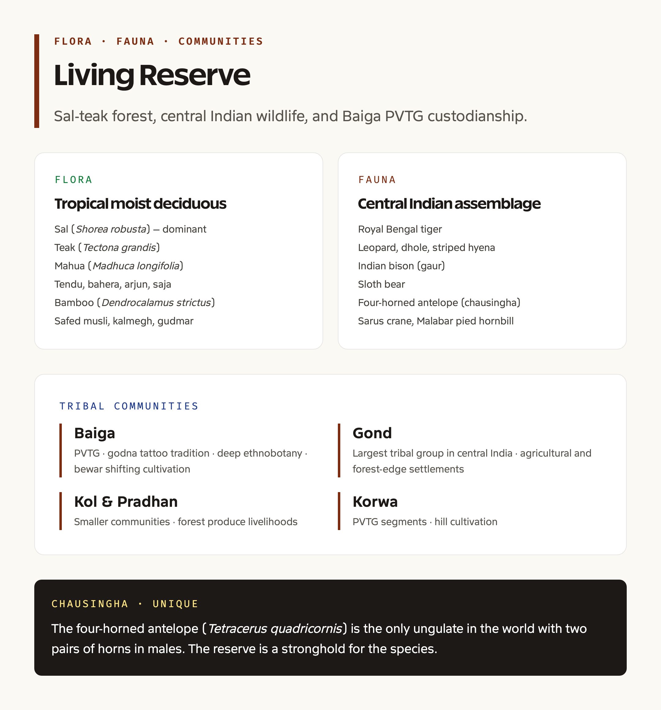
The reserve carries multiple values. Ecologically, it is one of the few intact moist deciduous landscapes in central India and forms a contiguous tiger habitat with the Kanha, Bandhavgarh, and Sanjay-Dubri tiger landscapes through the Bandhavgarh-Achanakmar corridor. Achanakmar Tiger Reserve, declared in 2009, is part of the Project Tiger network and contributes to the Madhya Pradesh-Chhattisgarh tiger metapopulation, which is one of the most important globally.
Hydrologically, the Amarkantak plateau is a primary source for water and soil conservation across central and northern India. Conservation of forest cover here directly influences the volume and quality of water flowing into the Narmada Basin (which supports irrigation across Madhya Pradesh, Maharashtra, and Gujarat), the Sone Basin (Bihar, Jharkhand, Madhya Pradesh), and the Mahanadi Basin (Chhattisgarh, Odisha).
Culturally, the reserve hosts Hindu and Adivasi sacred sites, the Baiga PVTG community, and a rich oral and material culture. The Baiga are known for their distinctive tattoo tradition (godna), shifting cultivation (bewar), and forest-based livelihoods that draw on a deep ethnobotanical knowledge.
Detailed Analysis: Flora and Fauna
The forests are predominantly tropical moist deciduous in the Champion-Seth scheme. Sal (Shorea robusta) is the dominant timber species, forming closed-canopy stands at moderate elevations. Teak (Tectona grandis) is co-dominant on better-drained slopes. Mahua (Madhuca longifolia), tendu (Diospyros melanoxylon), bahera (Terminalia bellerica), arjun (Terminalia arjuna), saja (Terminalia tomentosa), and bamboo (Dendrocalamus strictus) round out the canopy and understorey. Medicinal plants include safed musli, kalmegh, gudmar, and several rare orchids on the Amarkantak slopes. The ground flora supports a long list of grasses and forbs that drive livestock and herbivore productivity.
The fauna is a representative central Indian assemblage. The apex predator is the Royal Bengal tiger, present in Achanakmar Tiger Reserve in numbers that vary across census cycles. The leopard is the second large carnivore, more flexible across forest and edge habitats. The Indian bison or gaur (Bos gaurus) is present in small herds, particularly on the Chhattisgarh side. The four-horned antelope (chausingha, Tetracerus quadricornis) is a notable species; the only ungulate in the world with two pairs of horns in males. The sloth bear, dhole (Asiatic wild dog), striped hyena, and a long list of smaller carnivores round out the predator and scavenger guild. Avifauna includes the sarus crane, the Malabar pied hornbill, the Indian peafowl, several owls, and a rich migratory passerine assemblage in winter.
The reserve is a contiguous habitat for tigers along the Achanakmar-Bandhavgarh corridor, the Achanakmar-Kanha corridor, and the Achanakmar-Sanjay corridor. Maintaining these corridors is central to the long-term genetic viability of the central Indian tiger population.
Tribal Communities
The Baiga are the most distinctive community of the reserve. Recognised as a Particularly Vulnerable Tribal Group, they have a long-standing ecological knowledge of the forest, including a calendar of forest produce collection that minimises disturbance during nesting and fruiting seasons. The Baiga’s traditional bewar shifting cultivation is largely banned within the reserve, which has caused friction and required negotiated alternatives.
The Gond are the largest tribal group in central India and are present across the reserve in agricultural and forest-edge settlements. The Kol, Pradhan, and Korwa are smaller communities. Several villages within the buffer have received Community Forest Resource (CFR) rights under the Forest Rights Act, 2006, which gives the gram sabha legal authority to manage the local forest. The relationship between the Forest Department and the gram sabha is the central management dynamic in the buffer zone.
Comparative Frame
| UNESCO-Inscribed Indian Biosphere Reserves (Selected) | Year of MAB Inscription | States | Notable Features |
|---|---|---|---|
| Nilgiri | 2000 | TN, Kerala, Karnataka | Western Ghats, first Indian biosphere reserve (national, 1986) |
| Sundarban | 2001 | West Bengal | Mangrove tiger habitat |
| Gulf of Mannar | 2001 | Tamil Nadu | Coral reefs, dugongs, marine MAB |
| Nanda Devi | 2004 | Uttarakhand | Western Himalayan high altitude |
| Pachmarhi | 2009 | Madhya Pradesh | Satpura range, central India |
| Simlipal | 2009 | Odisha | Sal forest, melanistic tigers |
| Nokrek | 2009 | Meghalaya | Citrus indica, Khasi-Garo hills |
| Achanakmar-Amarkantak | 2012 | MP, CG | Maikal range, Narmada source |
| Great Nicobar | 2013 | A&N | Tropical rainforest, Shompen tribe |
| Agasthyamala | 2016 | Kerala, TN | Southern Western Ghats |
| Khangchendzonga | 2018 | Sikkim | Himalayan high altitude |
| Panna | 2020 | Madhya Pradesh | Tiger reintroduction |
India has 18 nationally notified biosphere reserves, of which 13 are inscribed on the UNESCO MAB network as of recent years.
Challenges
Several challenges constrain the reserve’s effectiveness. Tribal relocation from the Achanakmar core has been a long-running, contested process, with debates over consent, rehabilitation packages, and cultural continuity. Mining pressure, particularly bauxite around the Amarkantak periphery and coal in the wider Sohagpur and Korba blocks, presses against the buffer. Pilgrim pressure on Amarkantak town has expanded waste, water demand, and the urban footprint adjacent to the Narmada source. Forest fires through April and May, fuelled by leaf litter and exacerbated by rising temperatures, regularly burn through buffer compartments. Human-wildlife conflict, especially crop raiding by gaur and elephant straying from Bandhavgarh, presses on village livelihoods. Coordination across two state Forest Departments remains administratively complex.
Prelims Pointers
- Achanakmar-Amarkantak Biosphere Reserve was notified in 2005 and inscribed on UNESCO MAB in 2012
- The reserve straddles Madhya Pradesh and Chhattisgarh, with a small extension into Jharkhand
- The Maikal range connects the Vindhya and Satpura ranges
- Narmada, Sone, and Johilla rivers all originate on the Amarkantak plateau
- Arpa and Maniari rivers flow from the Achanakmar side
- Achanakmar Wildlife Sanctuary was declared a Tiger Reserve in 2009
- The Baiga are a Particularly Vulnerable Tribal Group (PVTG)
- The forests are tropical moist deciduous, dominated by sal and teak
- Four-horned antelope (chausingha) is a notable species; only ungulate with two pairs of horns
- India has 18 national biosphere reserves; 13 are UNESCO MAB inscribed
- The reserve is part of the central Indian tiger landscape connecting Bandhavgarh, Kanha, and Sanjay
Mains Practice Questions
- The Achanakmar-Amarkantak Biosphere Reserve has been called a “major watershed” of peninsular India. Discuss the ecological and hydrological significance of the reserve and the management challenges of a multi-state protected area.
- Examine the role of Particularly Vulnerable Tribal Groups, with reference to the Baiga community of Achanakmar-Amarkantak, in the conservation of central Indian forests. How can the Forest Rights Act, 2006 strengthen this role?
- UNESCO biosphere reserves are intended to integrate conservation, sustainable development, and research. Evaluate the implementation of this model in India, drawing on the case of Achanakmar-Amarkantak.
Way Forward
A long-term programme for Achanakmar-Amarkantak needs to integrate watershed management, tiger landscape connectivity, and community rights. Forest cover restoration in degraded buffer compartments through community-led plantations and assisted natural regeneration can strengthen the watershed function. Corridor protection towards Bandhavgarh, Kanha, and Sanjay-Dubri is essential and requires interstate coordination through the National Tiger Conservation Authority. Community Forest Resource recognition under the Forest Rights Act, 2006 should be extended to all eligible Baiga and Gond gram sabhas, with the Forest Department offering technical and financial support for management plans. Pilgrim infrastructure at Amarkantak needs an upgraded waste, water, and crowd management plan to reduce pressure on the Narmada source. Research and monitoring, especially long-term climate and hydrology data from the Amarkantak plateau, should be institutionalised through the MAB framework.
Frequently Asked Questions
What is the Achanakmar-Amarkantak Biosphere Reserve?
It is a UNESCO-inscribed biosphere reserve straddling Madhya Pradesh and Chhattisgarh, anchored by the Achanakmar Tiger Reserve on the Chhattisgarh side and the Amarkantak plateau on the Madhya Pradesh side. It covers around 3,835 square kilometres of moist deciduous forest along the Maikal range.
Which rivers originate from the Amarkantak plateau?
The Narmada, the Sone, and the Johilla all originate from the Amarkantak plateau within the biosphere reserve. The Arpa and the Maniari rise from the Achanakmar side and feed into the Mahanadi system.
When was the reserve inscribed on UNESCO’s MAB network?
The reserve was notified as a national biosphere reserve in 2005 and inscribed on UNESCO’s World Network of Biosphere Reserves in 2012.
Which tribal communities live in the reserve?
The main communities are the Baiga (a Particularly Vulnerable Tribal Group), the Gond, the Kol, the Pradhan, and the Korwa. Several gram sabhas have been recognised under the Forest Rights Act, 2006.
What is the core zone of the reserve?
The core zone is the Achanakmar Wildlife Sanctuary, which was further declared a Tiger Reserve under Project Tiger in 2009. Human activity in the core is strictly regulated.
Why is the Maikal range significant?
The Maikal range is the geological connector between the Vindhya and the Satpura ranges and forms a major watershed feeding the Narmada, Sone, and Mahanadi systems. The range provides the topographic and hydrological backbone of the biosphere reserve.
What forest type dominates the reserve?
The reserve is dominated by tropical moist deciduous forest, with sal (Shorea robusta) and teak (Tectona grandis) as the principal species, supported by mahua, tendu, bamboo, and a rich understorey.
What are the main wildlife species in the reserve?
The major species include the Royal Bengal tiger, leopard, Indian bison (gaur), sloth bear, four-horned antelope (chausingha), dhole, sarus crane, and a wide range of avifauna including the Malabar pied hornbill.
Is the Achanakmar Tiger Reserve part of a larger landscape?
Yes. The reserve forms a contiguous tiger landscape with Bandhavgarh, Kanha, and Sanjay-Dubri tiger reserves through forested corridors that are central to the long-term genetic viability of the central Indian tiger population.
What are the main threats to the reserve?
The main threats include mining pressure on the periphery, pilgrim and urban pressure on Amarkantak town, forest fires, human-wildlife conflict, and the difficulty of coordinating management across two state forest departments.