Central Place Theory: Christaller, Lösch and the Urban Hierarchy
Central place theory explained from threshold and range upward: why market areas are hexagonal, what the k = 3, 4 and 7 arrangements optimise, how Lösch differs from Christaller, and where India sits between the rank-size rule and primacy.
Central place theory explains why settlements of different sizes are spaced the way they are, and why a region ends up with many small towns, a few medium ones and a single large city rather than a random scatter. Walter Christaller published it in 1933 after measuring the service areas of towns in southern Germany, and August Lösch reworked it in 1940 from the producer’s side rather than the consumer’s. It remains the reference model for the urban hierarchy, and the reason it survives is not that its map is right but that its two governing quantities are.
Those two quantities are the threshold and the range, and almost everything else in the theory follows from the relationship between them.
Threshold and Range: the Two Quantities That Decide Everything
A central place is any settlement that supplies goods and services to the area around it. What decides its position in the hierarchy is the highest-order good it can support, and that in turn depends on two measurements.
- Threshold is the minimum demand, and so the minimum population, needed to make supplying a good worthwhile. A general store needs a few hundred people; a cardiac surgery unit needs several hundred thousand.
- Range of a good is the maximum distance a consumer will travel to obtain it. Nobody drives 40 kilometres for a loaf of bread; many will drive 200 for specialist treatment.
A good can be supplied at a place only when its range encloses enough people to meet its threshold. Low-order goods have a small threshold and a short range, so they are supplied everywhere. High-order goods have a large threshold and a long range, so they are supplied at few places. That asymmetry, and nothing else, generates the hierarchy.
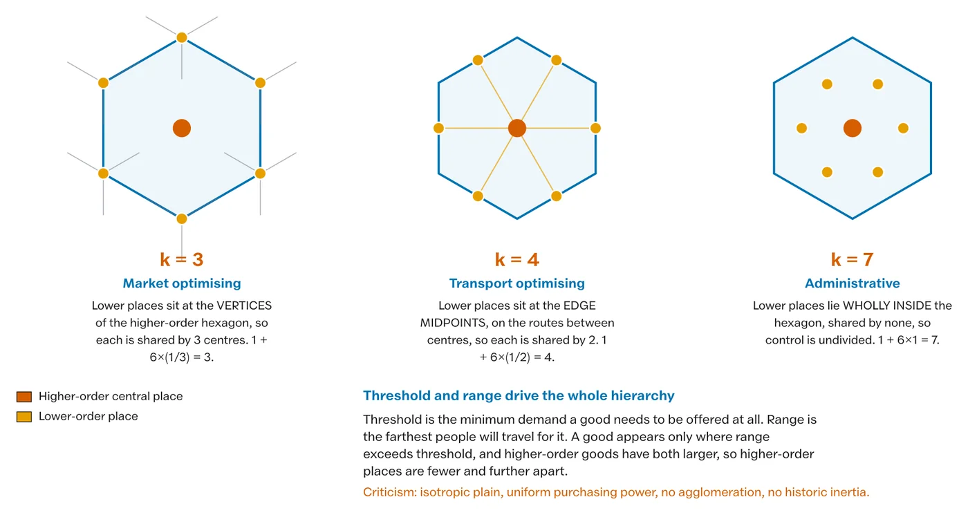
The consequence is a nested pattern. Every place that supplies a high-order good also supplies every lower-order good, because the population that justifies the rarer service more than justifies the common one. A hierarchy of central places is therefore a hierarchy of inclusion, not of specialisation.
Why the Market Areas Are Hexagons
Christaller assumed an isotropic plain: uniform relief, uniform purchasing power, uniform transport in every direction, and consumers who travel to the nearest place supplying what they want. On those assumptions each central place serves a circular area with a radius equal to the range of its highest-order good.
Circles will not tile a plane. Packed tightly they leave unserved gaps between them; overlapped enough to close the gaps, they leave contested slivers served twice. The only shape that tiles the plane without gaps, keeps every point as close as possible to its centre, and treats all directions alike is the regular hexagon. The hexagons in the diagram are therefore not decoration and not an assumption; they are the geometric consequence of the assumptions already made.
The Three K-Values
The k-value states how many places of a lower order each higher-order place serves, counting itself and its share of the ones on its boundary. Christaller derived three arrangements, each optimising something different, and the exam value of the model is knowing which one applies where.
| Arrangement | k | What it optimises | Where the lower centres sit |
|---|---|---|---|
| Marketing principle | k = 3 | The smallest number of central places able to supply the whole plain | At the corners of the hexagon, shared between 3 higher centres |
| Transport principle | k = 4 | The greatest number of places lying on straight routes between higher centres | At the mid-points of the hexagon edges, shared between 2 |
| Administrative principle | k = 7 | Undivided control, since no lower place is shared | Entirely inside the hexagon, 6 of them plus the centre |
Read the k-value as the multiplier of the hierarchy. Under k = 3 each level has 3 times as many places as the level above it; under k = 7, 7 times. A real settlement system rarely follows one principle throughout, and the useful observation is that administrative systems tend toward k = 7 while market systems tend toward k = 3, so a region with a strong administrative history has a flatter, more evenly spaced hierarchy than a purely commercial one.
Lösch: the Same Landscape Seen from the Producer’s Side
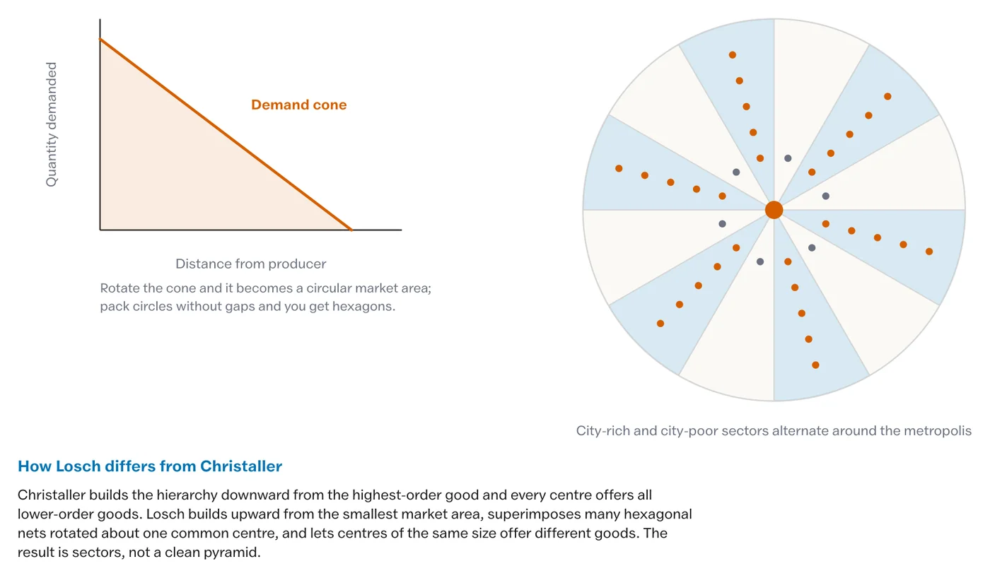
August Lösch began from the individual firm rather than from the settlement, and asked what market area each product needs in order to be produced at all. Because different goods have different thresholds, each produces its own hexagonal net of a different size. Superimposing all those nets and rotating them about one common centre produces a landscape with city-rich and city-poor sectors radiating from the centre.
Three differences from Christaller are worth holding, because they are what the comparison question turns on.
- Lösch’s hierarchy is not strictly nested. A place can supply a high-order good without supplying every lower-order one, which is closer to what is actually observed.
- His landscape has sectors of differing density rather than a uniform lattice, so it accommodates the real clustering of industry.
- He was describing an economic landscape rather than an administrative one, and produced a continuum of settlement sizes rather than discrete steps.
Christaller asks how few places can serve everyone. Lösch asks how many products can survive. The first gives a tidy lattice, the second gives a realistic mess.
Rank-Size, the Primate City and Where India Sits
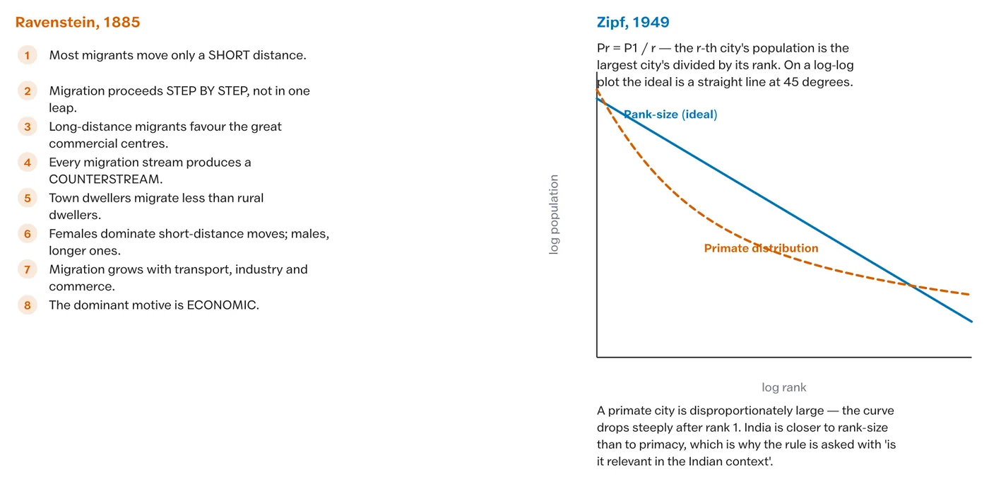
The hierarchy that central place theory predicts can be tested against the actual size distribution of settlements. The rank-size rule, stated by George Zipf in 1949, holds that the population of a settlement is roughly the population of the largest divided by that settlement’s rank: the second city is about half the first, the tenth about a tenth. Plotted on logarithmic axes it is a straight line.
A departure at the top is primacy. Mark Jefferson’s law of the primate city, from 1939, observed that a country’s largest city is commonly far larger than the second and disproportionately expressive of national life. Bangkok, Buenos Aires, Seoul and Paris are the standard cases.
India is the interesting case because it does not fit either pattern cleanly. At national level the size distribution follows the rank-size rule fairly well, because no single city dominates a subcontinent with several historic cores. At state level the picture reverses: Maharashtra, West Bengal, Tamil Nadu and Telangana each have one city that dwarfs the second, because a state capital or a colonial port concentrated administration, industry and migration in one place. The honest answer to whether India is primate is therefore it depends on the scale of the unit, and giving that answer with the two levels named is what separates a good treatment from a recited one.
The Standing Criticisms
The model’s assumptions are its vulnerabilities, and a fair assessment names them without dismissing the model.
- The isotropic plain does not exist. Relief, rivers, soil quality and mineral deposits all break the uniformity the hexagons require.
- Transport is not uniform in every direction. Real networks are corridors, which is precisely why the k = 4 arrangement was needed and why real settlement strings out along routes.
- Consumers do not always go to the nearest place. They combine trips, follow habit, and prefer a larger centre with more choice, which behavioural geography documented in detail.
- It is a static equilibrium model. It says nothing about how a hierarchy arrives at its pattern, and nothing about the growth of any single town.
- It describes service centres, not industrial cities. A steel town or a mining settlement owes its size to a resource, not to a market area, and sits in the hierarchy at the wrong level for its function.
The last point matters most in India, where a great many towns exist because of a railway junction, a cantonment, a temple or a factory rather than because of a threshold and a range.
Central Place Theory in the Indian Context
Applied carefully, the model still earns its place in Indian settlement geography in three ways.
- As a planning tool. Locating a public facility means asking what population threshold it needs and what distance people will travel to it, which is exactly the threshold-and-range calculation. India’s block and tehsil headquarters approximate a k = 7 administrative arrangement.
- As a diagnostic. Where the observed hierarchy has a missing tier, the region has a gap in its service provision, and that is measurable rather than impressionistic.
- As a comparison. The Ganga plain, with dense, evenly spaced market towns on fertile flat land, comes closer to the model than anywhere else in the country. The Deccan, with towns strung along road and rail corridors, fits the transport principle better. The Himalaya fits neither, since valley geometry decides everything.
Practice Questions
Prelims
1. Threshold, in central place theory, refers to
- (a) the maximum distance a consumer will travel for a good
- (b) the minimum population required to support the supply of a good
- (c) the number of lower-order centres served by a higher-order centre
- (d) the radius of the hexagonal market area
Answer: (b)
2. The k = 4 arrangement in Christaller’s scheme optimises
- (a) administrative control
- (b) the number of central places
- (c) the alignment of lower centres along transport routes
- (d) the size of the market area
Answer: (c)
3. Which of the following is true of Lösch’s model but not Christaller’s?
- (a) Market areas are hexagonal
- (b) The hierarchy is strictly nested
- (c) City-rich and city-poor sectors emerge
- (d) Consumers travel to the nearest centre
Answer: (c)
4. The rank-size rule states that the population of a settlement is approximately
- (a) equal to that of the largest settlement
- (b) the largest settlement’s population divided by its rank
- (c) the mean of all settlements
- (d) proportional to its area
Answer: (b)
5. The law of the primate city was stated by
- (a) Walter Christaller
- (b) August Lösch
- (c) Mark Jefferson
- (d) George Zipf
Answer: (c)
Mains
- Explain the concepts of threshold and range, and show how the relationship between them generates a hierarchy of central places. (10 marks)
- Why are the market areas in Christaller’s model hexagonal? Discuss the assumptions from which that geometry follows. (10 marks)
- Compare Christaller’s and Lösch’s models of the settlement landscape, and account for the differences in their outcomes. (15 marks)
- “India follows the rank-size rule nationally and is primate regionally.” Examine this statement with examples. (15 marks)
- Critically assess the relevance of central place theory to settlement planning in India today. (20 marks)