Brahmaputra Mega Dam: Transboundary Risks at the Great Bend
Why in News?
China’s renewable-energy plan calls for advancing the lower-reaches Yarlung Zangbo hydropower project near the Great Bend, renewing Indian concerns about uncertain downstream effects and limited project information.
- China’s official plan confirms continued construction priority, while a 2025 government announcement describes five cascade hydropower stations rather than publishing a complete operating design.
- The Hindu reports that a September meeting of the India-China Expert-Level Mechanism on trans-border rivers is expected to discuss cooperation.
- Analysts cited by the newspaper project about 60 GW of capacity, but China has not officially published the project’s final capacity, reservoir size or tunnel configuration.
- Claims about water diversion, altered flows or downstream harm remain risk scenarios; they cannot be treated as established outcomes without design and operating data.
- The project sits where a transboundary river, a high-relief Himalayan landscape and a major energy intervention meet, making uncertainty itself a governance problem.
- For India and Bangladesh, timely flow data, sediment information and emergency warnings matter alongside any debate about annual water availability.
UPSC Relevance
Prelims Relevance
- Yarlung Zangbo, Siang or Dihang, and Brahmaputra
- Great Bend and Namcha Barwa region
- Run-of-the-river hydropower
- Cascade hydropower stations
- India-China Expert-Level Mechanism on trans-border rivers
- Flood-season hydrological data
Mains Relevance
GS Paper 2
- India-China river diplomacy, transparency and confidence-building
- Interests of lower-riparian States and cooperative transboundary governance
GS Paper 3
- Hydropower, environmental flows, sediment continuity and disaster-risk reduction
- Infrastructure assessment in a seismically active Himalayan region
Essay
- Infrastructure becomes a shared-security issue when decisions taken upstream redistribute uncertainty across borders.
Background and Context
Why the Great Bend Matters
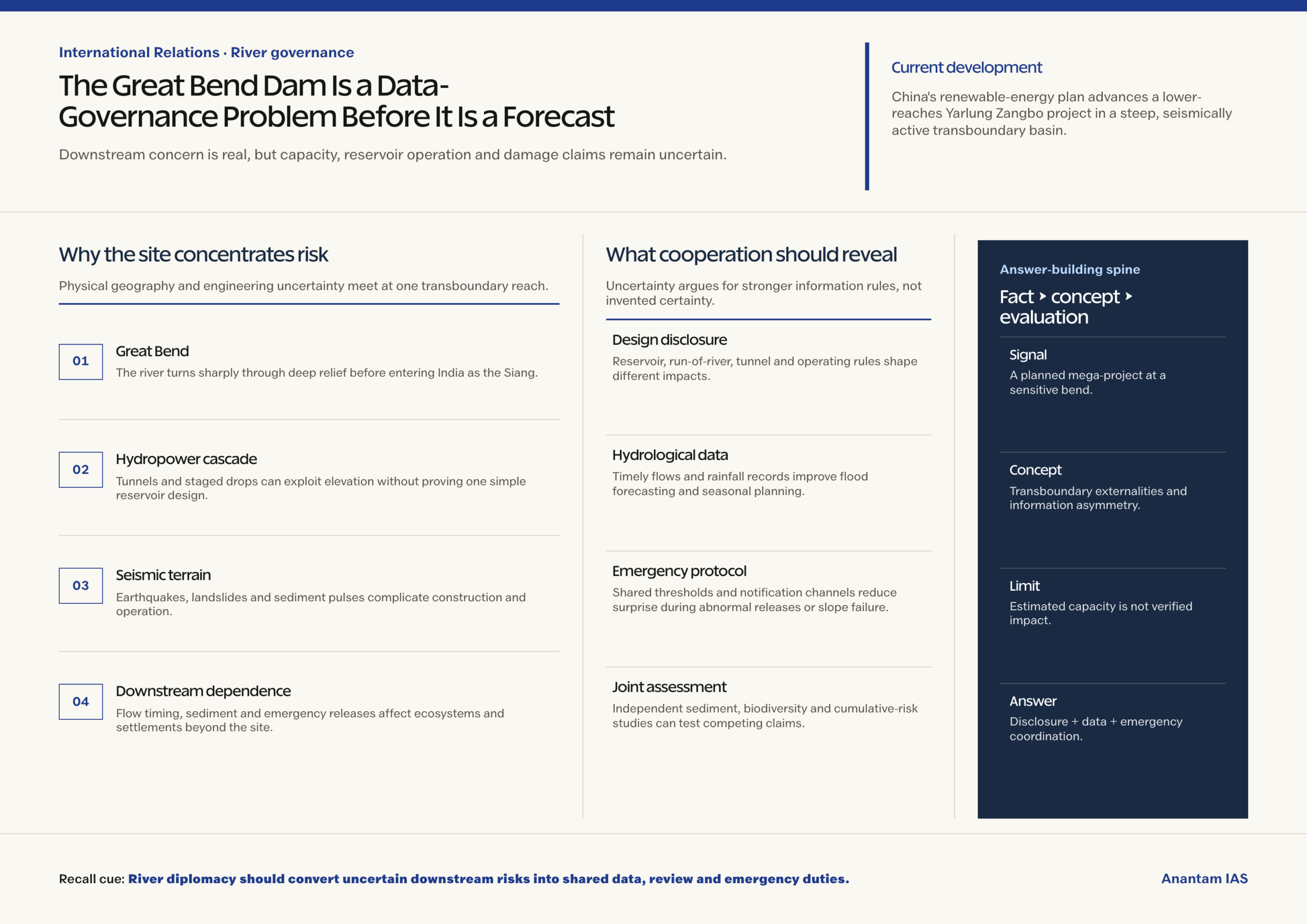
The site’s strategic value comes from the river’s geography, not merely the scale attached to the proposed project.
- The river flows east across Tibet as the Yarlung Zangbo, turns sharply around the Namcha Barwa region, cuts through deep relief and then enters Arunachal Pradesh.
- In Arunachal Pradesh it is commonly called the Siang or Dihang; after meeting the Dibang and Lohit, it flows across Assam as the Brahmaputra and later enters Bangladesh.
- The Great Bend combines a steep fall and concentrated river energy. That makes hydropower attractive, but also places tunnels, slopes, access works and powerhouses in difficult terrain.
- China’s 2025 announcement confirmed five cascade stations and the start of construction. The later renewable-energy plan makes continuation a policy commitment rather than a speculative proposal.
- Analyst descriptions of a long diversion tunnel and roughly 60 GW remain estimates. Publicly available official material does not establish final reservoir storage or operating rules.
How a Hydropower Project Can Change a River
Downstream effects depend on engineering choices and operations, so the correct frame is conditional rather than alarmist.
- A run-of-the-river label does not mean zero impact. Intake structures, pondage, tunnels and peaking operations can alter flow timing even when long-term diversion is limited.
- Reservoir size and release rules determine whether water is mainly passed through, stored across seasons or released in short pulses. Those details have not been publicly settled for this project.
- Dams and tunnels can interrupt sediment continuity, affect fish movement and change channel-forming flows. Magnitude depends on design, environmental-flow rules and coordinated cascade operation.
- The Eastern Himalayan Syntaxis is highly seismically active. Assessment must cover ground shaking, slope instability, tunnel safety and cascading failure pathways without assuming that failure is inevitable.
- Construction footprints, spoil disposal, roads and transmission corridors may create ecological pressure beyond the dam site. A basin-scale cumulative assessment is more useful than a structure-only review.
The Cooperation Gap
India-China river cooperation exists, but its data-sharing arrangements have been narrower and less dependable than the risks now being debated.
- The Expert-Level Mechanism, established in 2006, provides an official channel for flood-season data, emergency management and discussion of other trans-border river issues.
- A 2013 memorandum extended Brahmaputra data provision from May 15 to October 15 and recognised the value of cooperation to riparian countries.
- An official parliamentary reply states that the Brahmaputra data MoU expired in June 2023 and data sharing was suspended from that month.
- Flood-season gauge readings alone cannot resolve project uncertainty. Downstream assessment also needs reservoir levels, planned outages, sediment data, operating rules and prompt notification of unusual releases.
- Cooperation should include India and Bangladesh as lower-riparian stakeholders. Shared models and verified data can distinguish manageable impacts from unsupported worst-case claims.
Way Forward
Move from Assurance to Verifiable Cooperation
Confidence will depend on information that downstream agencies can independently use, not on competing political claims.
- Seek disclosure of the project layout, reservoir characteristics, tunnel alignment, environmental-flow commitments, sediment-management plan and operating rules through the Expert-Level Mechanism.
- Restore continuous hydrological exchange with common data standards, real-time transmission, quality checks and automatic warnings for abnormal releases, landslides or infrastructure emergencies.
- Create a joint scientific review covering seismic hazards, slope stability, ecology and cumulative cascade effects, with periodic publication of methods, assumptions and monitoring results.
- Strengthen India’s own upstream gauges, satellite monitoring, flood forecasting and community warning systems so that preparedness does not depend on a single external data stream.
Conclusion
- The lower-reaches project is a major planned hydropower intervention, but its capacity, storage, tunnel effects and downstream consequences remain partly undisclosed or analyst-estimated rather than established facts.
- A sound answer should connect Great Bend geography with conditional environmental and seismic risks, then argue for transparent design disclosure, restored hydrological data and basin-wide emergency cooperation.
UPSC Practice Questions
Prelims MCQ 1
With reference to the Brahmaputra river system, consider the following statements:
- The river is known as the Yarlung Zangbo in Tibet.
- It enters India in Arunachal Pradesh, where it is commonly called the Siang or Dihang.
- It is called the Brahmaputra before meeting the Dibang and Lohit rivers.
How many of the above statements are correct?
(a) Only one (b) Only two (c) All three (d) None
Answer: (b) Only two
Explanation:
Statements 1 and 2 are correct. The name Brahmaputra is used after the Siang or Dihang meets major tributaries including the Dibang and Lohit in the Assam plains.
Prelims MCQ 2
What is the most accurate function of the India-China Expert-Level Mechanism on trans-border rivers?
(a) It allocates fixed shares of Brahmaputra water between the two countries. (b) It approves every hydropower project proposed by either country. (c) It provides a channel for hydrological data, emergency management and discussion of trans-border river issues. (d) It adjudicates disputes through binding awards.
Answer: (c) It provides a channel for hydrological data, emergency management and discussion of trans-border river issues.
Explanation:
The mechanism is a cooperation and discussion channel. It is not a water-allocation treaty, a project-clearance authority or a binding international tribunal.
UPSC Mains Questions
- The uncertainty surrounding the lower-reaches Yarlung Zangbo hydropower project is itself a transboundary governance risk. Discuss.
- Explain how Great Bend geography, seismic conditions and cascade hydropower operations shape India’s concerns over the Brahmaputra. Suggest practical confidence-building measures.
Sources: The Hindu and National Development and Reform Commission, China.
Frequently Asked Questions
Where is the proposed Brahmaputra mega dam located?
The project is on the lower reaches of the Yarlung Zangbo in Tibet, near the Great Bend where the river turns around the Namcha Barwa region before entering Arunachal Pradesh.
Is the project’s 60 GW capacity officially confirmed?
No. The figure is an analyst projection cited in reporting. Official Chinese announcements confirm five cascade stations and major investment, but do not publicly establish a final installed capacity.
Does run-of-the-river hydropower have no downstream impact?
No. Pondage, intake structures, tunnels and peaking releases can alter flow timing, sediment movement and ecology. The actual effect depends on design, storage and operating rules.
What is the India-China Expert-Level Mechanism?
Created in 2006, it is the bilateral channel for cooperation on flood-season hydrological data, emergency management and other trans-border river issues. It is not a water-sharing treaty.
Why is hydrological data sharing important for India?
Timely, reliable upstream data improves flood forecasting and emergency warnings. Project-specific reservoir, release and sediment information would also help agencies assess risks instead of relying on competing claims.