Earthquake in Kamchatka Peninsula

Why in News:
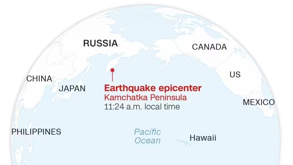
One of the strongest earthquakes ever recorded struck Russia’s sparsely populated far east on July 30, causing tsunamis up to four metres (12 feet) across the Pacific and sparking evacuations from Hawaii to Japan. The magnitude 8.8 quake struck in the morning off Petropavlovsk on Russia’s remote Kamchatka peninsula and was one of the 10 biggest recorded, according to the United States Geological Survey (USGS).
UPSC CSE Relevance:
UPSC CSE in prelims and mains examination has focused on Important Geophysical phenomena such as earthquakes, Tsunami, Volcanic activity, cyclone etc. A case in point is a following PYQ.
UPSC mains PYQ 2020:
Discuss the geophysical characteristics of Circum- Pacific Zone.
What is an earthquake?
As per NCERT, an earthquake is defined as a sudden shaking or trembling of the earth. It can be caused either naturally or anthropogenically. Based on these causal factors, there are following types of earthquakes:
Types of Earthquakes:
Natural Earthquakes –
These are caused by natural processes occurring inside the Earth
Tectonic Earthquakes:
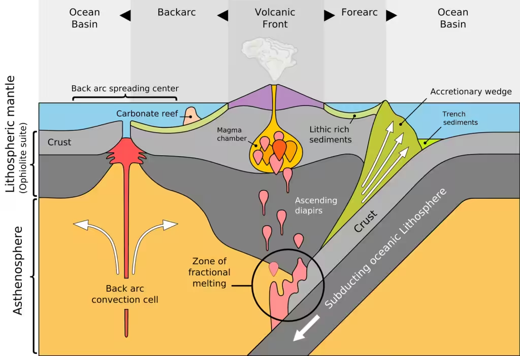
Cause: Sudden movement of tectonic plates along faults or plate boundaries. Majorly caused due to subduction of tectonic plates.
- This process results in deformities and creates a huge stress at the plate boundaries. It is this stress that is released in the form of earthquakes.
- Subduction is a geological process in which one tectonic plate-put simply, a large section of the Earth’s crust-presses against another. Usually, the heavier or denser plate, that is, the one with more mass per unit of area, tends to go below the lighter plate.
Location: Occur mostly in subduction zones, transform faults, and mid-ocean ridges.
Example:
- Recent quake in Kamchatka.
- San Andreas Fault (USA) – Strike-slip tectonic fault
- 2004 Indian Ocean Earthquake – Caused by subduction of the Indian Plate
- Earthquake in Anatolian region in Turkey in 2023.
Volcanic Earthquakes:
- Cause: Result from volcanic activity like magma movement or eruption.
- Location: Usually near active volcanoes.
Example:
- Japan and Indonesia – Volcanic belts
- Earthquakes around Mount St. Helens (USA)
Collapse Earthquakes:
- Cause: Collapse of underground caves, caverns, or mines (typically in karst areas).
- Location: Local and minor in intensity.
Example:
- Sinkholes in limestone regions
- Minor quakes due to mine collapses in coal regions.
Man-Made (Artificial) Earthquakes:
Mining-Induced Earthquakes
- Cause: Explosions or deep excavation in mining areas.
- Example: Rock bursts in deep coal mines (South Africa, Poland).
Reservoir-Induced Earthquakes
- Cause: Filling of large dams creates pressure on bedrock, reactivating faults.
- Example: Koyna Dam (India) – Well-known example of human-induced seismicity.
Nuclear Explosions
- Cause: Underground nuclear tests displace rocks and generate seismic waves.
- Example: Nuclear test sites like Nevada (USA) or Pokhran (India).
Other Human Activities
- Cause: Deep well injection, fracking (hydraulic fracturing), geothermal projects.
- Example:
- Induced tremors near geothermal plants in Iceland and California.
- Earthquakes in Oklahoma (USA) linked with fracking
Distribution of EQ – 3 Major Zones:
65 – 70 % EQ in Circum-Pacific Zone (with 80% of big EQs):
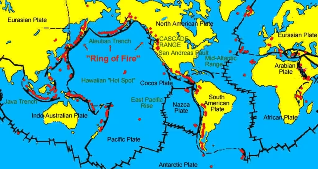
Reason:
- Active volcanoes
- Subduction zones
- High energy accumulation for longer durations
- young fold mountains – unstable topography
20- 25 % in Mid-Continental Belt or [Alpide-Himalayan Belt]:
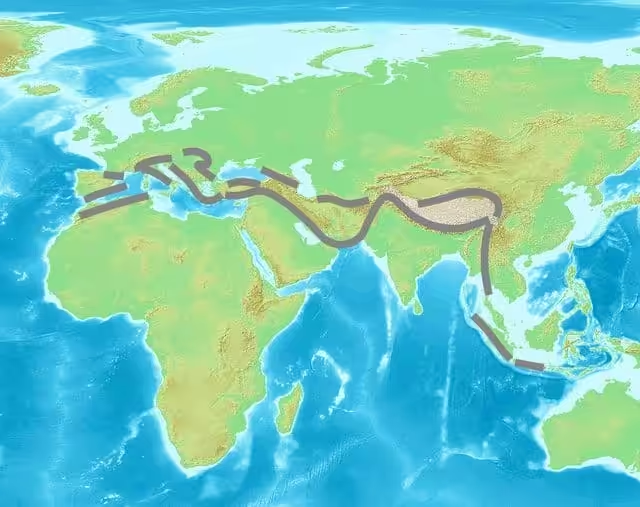
Reason:
- Example-Turkey (Anatolian plate)
- weak zone of fold mountains like Himalayas
- fault induced EQ due to faults zones like that of Anatolia
- High risk of damage due to high population density
Mid Atlantic Ridge Area:
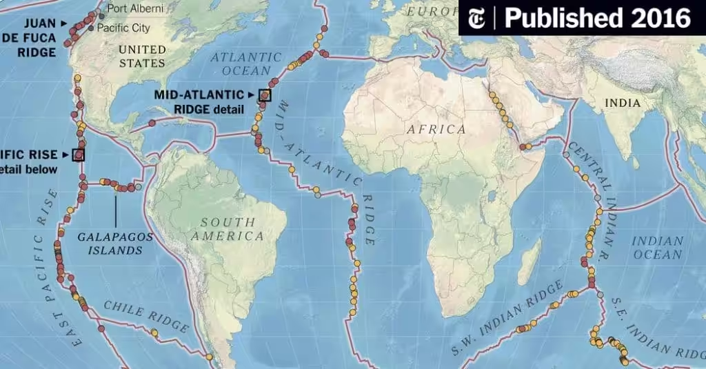
- shallow focii EQs due to Diverging boundaries
- under the ocean, far from populated areas.
Rift zones with neo-tectonic activity(new tectonic faults and fractures) are also prone to EQs.
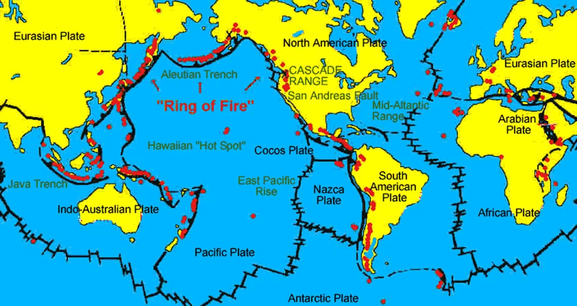
Ex. African Rift valley
What is the Ring of Fire?
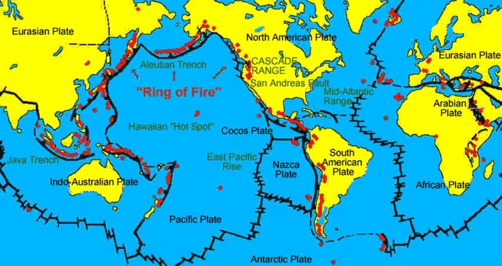
The Ring of Fire is a horseshoe-shaped belt around the edges of the Pacific Ocean. It is known for having the most active volcanoes and earthquakes in the world.
- Major Subduction Zones:
- It is located along convergent boundaries, where oceanic plates subduct under continental plates causing EQs and volcanic eruptions.
- Nazca Plate subducting under South American Plate (e.g., Chile)
- Pacific Plate subducting under Philippine and Eurasian Plates
- Juan de Fuca Plate under North America (Cascadia Subduction Zone)
- The recently Kamchatka EQ Zone lies near Ring of Fire.
How is EQ measured?
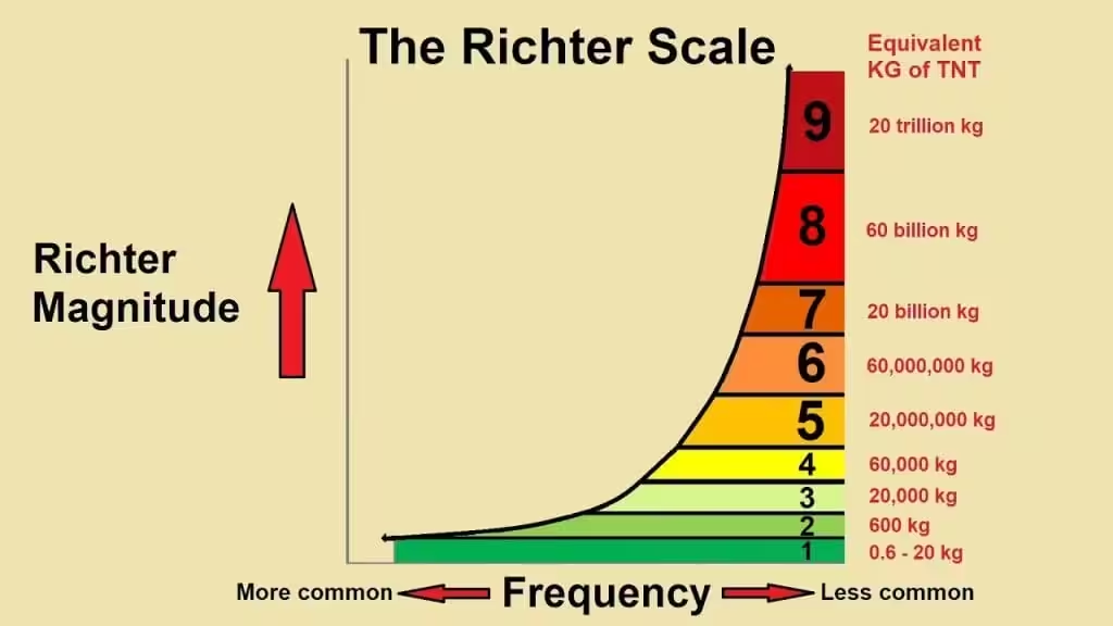
Richter Scale (Magnitude Scale) – measures the energy released at the source of an earthquake developed by Charles F. Richter in 1935.
- Scale Range: From 0 to 10+ (logarithmic scale).
- Each whole number increase represents: 10 times more ground shaking and 32 times more energy release.
- Example: A 6.0 magnitude earthquake releases 32 times more energy than a 5.0.
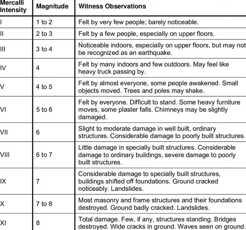
Modified Mercalli Intensity (MMI) Scale:
- measures the impact and damage caused by an earthquake (human perception, building suffering, etc.).
- Scale Range: From I (not felt) to XII (total destruction).
- Subjective: Varies based on people’s experiences and structures in a specific area.
Impact of EQs:
- Damage to property and life.
- Development of new faults Ex- Allah Bund Fault after Delhi-Bhuj EQ
- Landslides, avalanches, ground lurching
- Tsunamis. Ex-Tsunami 2004-India, S-E Asia, Japan Tsunami, 2011
- Soil Liquefaction – a phenomenon where saturated or loosely packed soil loses its strength and stiffness, behaving like a liquid, due to strong stress like earthquake shaking.
- Ex- Northern Part of Bihar in riverine area after EQ in Nepal, 2015
- Dam levee failures causing flooding.
NDMA Guidelines for Earthquake Management:
- Risk Assessment and Hazard Mapping
- Identify seismic zones and prepare microzonation maps.
- Update building by-laws based on seismic risk.
- Create earthquake vulnerability atlases for states/districts.
2. Building Safety and Infrastructure
- Enforce seismic-safe construction provisions in buildings and infrastructure.
- Promote use of IS Codes (Indian Standards) related to earthquake-resistant construction.
- Retrofit critical lifeline buildings (schools, hospitals, water supply, etc.).
- Ensure proper evaluation and retrofitting of public and private buildings, especially in Zones III–V.
3. Training, Awareness, and Capacity Building
- Train engineers, architects, and masons in earthquake-resistant design and construction.
- Conduct public awareness campaigns in schools, offices, residential areas.
- Establish disaster response teams and conduct regular earthquake mock drills.
4. Early Warning and Communication Systems
- Develop and improve earthquake early warning systems (EEWS).
- Strengthen seismic networks in high-risk areas.
- Set up robust communication channels between agencies, emergency services, and communities.
5. Emergency Response Planning
- Prepare site-specific Earthquake Disaster Management Plans at District, State, and National levels.
- Ensure availability of search and rescue teams, medical teams, temporary shelters, and essential supplies.
- Coordinate with NDRF (National Disaster Response Force) and civil defense units.
6. Land Use and Urban Planning
- Integrate earthquake risk reduction in urban development master plans.
- Restrict building and settlement in high-risk zones as per hazard mapping.