EOS-05: Imaging Earth From Geosynchronous Orbit
Why in News?
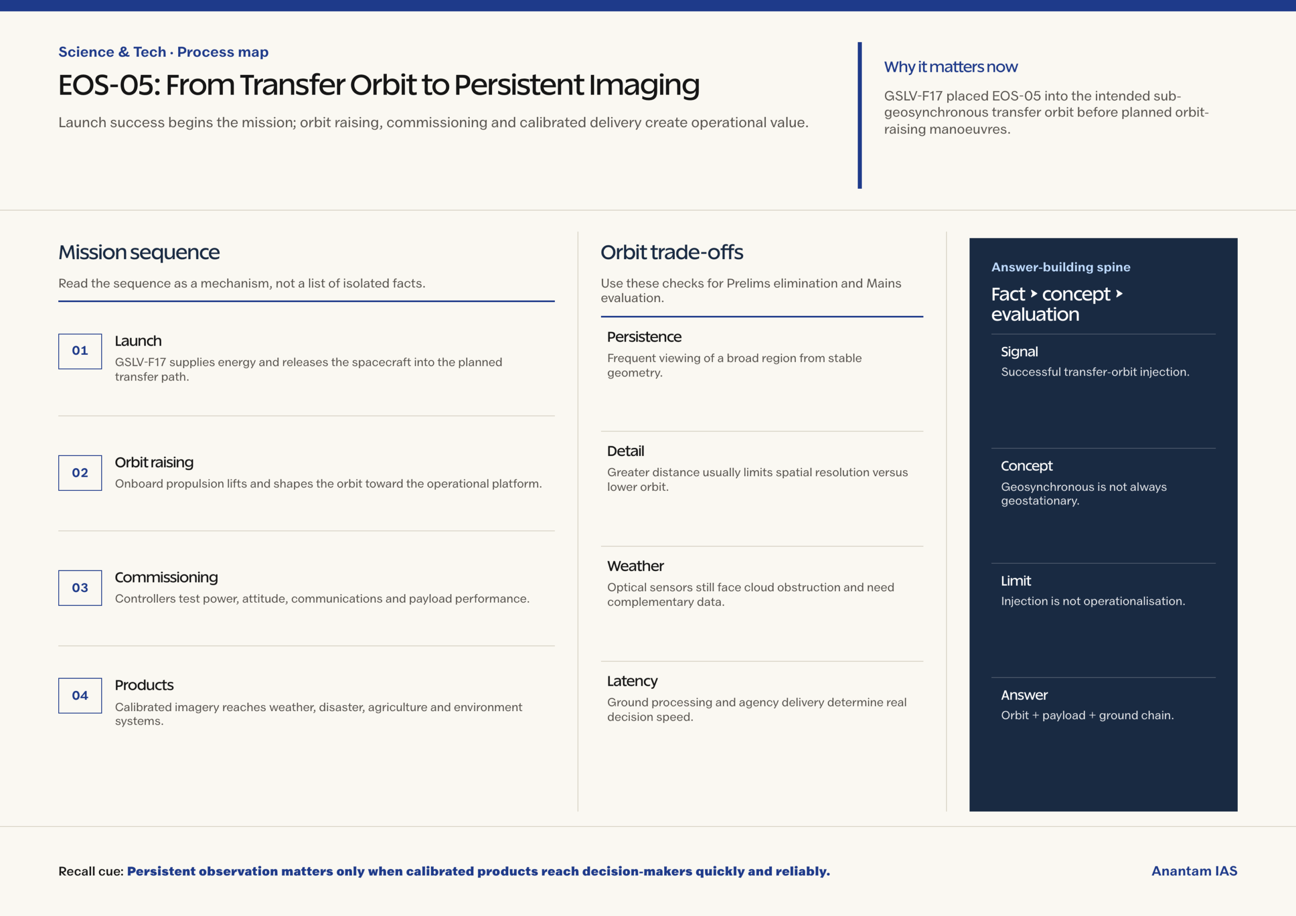
ISRO’s GSLV-F17 successfully launched EOS-05 at 2:55 a.m. on 4 September and placed it into the intended sub-geosynchronous transfer orbit.
- EOS-05 is India’s first imaging satellite designed to observe Earth from geosynchronous orbit.
- The 2,367 kg spacecraft was injected about 18 minutes after launch from the second launch pad at Sriharikota.
- ISRO reported normal spacecraft health and solar-array deployment after injection.
- Further orbit-raising manoeuvres are required before the satellite reaches its operational geosynchronous platform.
- A transfer-orbit injection is a launch milestone, not the same as final operational positioning or commissioned data service.
- High-altitude persistence complements lower-orbit detail by allowing frequent observation of a broad region from a stable viewing geometry.
UPSC Relevance
Prelims Relevance
- Geosynchronous orbit has an orbital period matching Earth’s rotation.
- A geostationary orbit is a circular, equatorial geosynchronous orbit that appears fixed over one longitude.
- A transfer orbit is an intermediate elliptical path used before orbit raising.
- GSLV uses a cryogenic upper stage for high-energy missions.
- Earth-observation data support weather, agriculture, environment and disaster management.
Mains Relevance
GS Paper 3
- Space-based Earth observation for disaster response and strategic autonomy
- Launch reliability, orbital insertion and downstream data systems
GS Paper 1
- Remote sensing, spatial monitoring and geographic applications
Essay
- The value of a space mission lies not only in reaching orbit but in converting persistent observation into timely public decisions.
Background and Context
Why Geosynchronous Imaging Matters
A high-altitude satellite can repeatedly observe the same broad region, supporting persistence where lower-orbit satellites pass only at intervals.
- Geosynchronous means the satellite’s orbital period matches Earth’s rotation, allowing a recurring view relative to the planet.
- A geostationary satellite is the special circular and equatorial case that appears fixed above one longitude to a ground observer.
- Persistent viewing can track rapidly evolving cloud systems, fires, floods or other events without waiting for the next low-Earth-orbit pass.
- The tradeoff is spatial detail: greater distance usually reduces achievable ground resolution compared with many lower-orbit imaging systems.
- Viewing geometry also affects latitude coverage, cloud obstruction and sensor design, so high temporal frequency does not guarantee a usable image of every event.
Launch Is Only the First Orbital Step
GSLV-F17 inserted EOS-05 into an elliptical transfer orbit from which the spacecraft must raise and shape its final orbit.
- The launch vehicle supplies most initial energy and releases the spacecraft into a planned orbit with specific altitude, inclination and velocity conditions.
- Spacecraft propulsion then performs orbit-raising burns, progressively lifting the low point and adjusting the path toward the intended platform.
- Controllers verify power, communication, thermal behaviour, attitude control and propulsion before declaring the spacecraft ready for payload commissioning.
- Operational status follows calibration and validation; a successful injection does not itself prove that every imaging product is available.
- Station-keeping later preserves orbital position against perturbations, consuming onboard propellant and linking mission life to propulsion, mass and operational choices.
A Complementary Observation Architecture
No single orbit optimises persistence, resolution, coverage and latency, so resilient Earth observation combines platforms with different strengths.
- Low-Earth-orbit satellites can provide finer spatial detail but observe a given location intermittently as their ground track moves.
- Geosynchronous imaging can provide frequent regional updates, improving temporal continuity for changing hazards and strategic monitoring.
- Weather, radar, optical and multispectral instruments answer different questions and must be combined with ground observations and domain models.
- Useful data also require receiving stations, processing chains, secure archives, open standards and delivery systems that reach operational agencies quickly.
- Rapid products should be fused with field reports because remote sensing can detect patterns but may not reveal local exposure, damage or required relief by itself.
Limits of Persistent Observation
High revisit frequency improves situational awareness, but clouds, sensor resolution, calibration and downstream latency still determine whether imagery supports action.
- Optical imaging cannot see through dense cloud, making radar and meteorological observations important complements during monsoon hazards.
- Strategic imagery also raises questions of access, classification and civil-agency sharing, which can affect how quickly public applications receive products.
- Long mission value depends on fuel, radiation resilience, component health and ground control, not only the performance of the launch vehicle.
Way Forward
Convert Persistence Into Decisions
Mission value will depend on commissioning, calibrated products and dependable use by agencies rather than launch success alone.
- Complete orbit raising and publish commissioning milestones without treating transfer-orbit injection as full operationalisation.
- Validate imagery against ground truth and disclose resolution, revisit, latency and uncertainty for each product.
- Integrate rapid products with disaster, agriculture, environment and weather decision systems.
- Build continuity through complementary satellites, redundant ground infrastructure and clear data-access protocols.
Conclusion
- EOS-05’s distinctive value is persistent regional observation, while its mission sequence runs from launch and transfer orbit through raising, calibration and operational data delivery.
- A strong answer should compare orbital tradeoffs and connect spacecraft architecture with the ground systems that turn imagery into public value.
UPSC Practice Questions
Prelims MCQ 1
With reference to satellite orbits, consider the following statements:
- Every geosynchronous orbit must be circular and equatorial.
- A geostationary satellite appears fixed above one longitude.
- A transfer orbit can be used before reaching the operational orbit.
How many of the above statements are correct?
(a) Only one (b) Only two (c) All three (d) None
Answer: (b) Only two
Explanation:
Statements 2 and 3 are correct. Geostationary is the circular equatorial special case; geosynchronous orbits can have inclination or eccentricity.
Prelims MCQ 2
What is the main observational advantage of a geosynchronous imaging platform?
(a) Zero launch-energy requirement (b) Persistent or frequently repeated viewing of a broad region (c) Guaranteed finer detail than every low-orbit satellite (d) No need for ground processing
Answer: (b) Persistent or frequently repeated viewing of a broad region
Explanation:
Matching Earth’s rotation supports recurring regional viewing, though resolution and distance create tradeoffs.
UPSC Mains Questions
- Explain how geosynchronous imaging complements low-Earth-orbit observation for disaster management and environmental monitoring.
- A successful launch is only one stage in an Earth-observation mission. Discuss the chain from orbital insertion to public decision support.
Sources: ISRO and The Hindu.
Frequently Asked Questions
What happened in the EOS-05 mission?
GSLV-F17 launched EOS-05 and placed it into the intended sub-geosynchronous transfer orbit; later manoeuvres are needed for its operational platform.
Is geosynchronous the same as geostationary?
No. Geostationary is the circular, equatorial geosynchronous case that appears fixed above one longitude.
Why use a transfer orbit?
It lets the launch vehicle place a spacecraft on an energy-efficient intermediate path before onboard propulsion raises and shapes the final orbit.
What can persistent imaging support?
Frequent regional observations can help track evolving weather, fires, floods, agriculture, environmental change and strategic activity when combined with other data.
Was EOS-05 operational immediately after launch?
No. Successful injection and healthy systems are early milestones; orbit raising, payload commissioning, calibration and product validation still follow.