Great Nicobar Project

Why in news:
A tribal council from Great Nicobar Islands has submitted a complaint to Union Minister of Tribal Affairs Jual Oram, alleging that:
- This claim was used to gain forest clearances for the ₹72,000 crore Great Nicobar infrastructure project which includes a transshipment port, airport, power plant, and township. The complaint argues that the due process under FRA(forest right act) was bypassed, and consent for forest land diversion was not properly obtained from the affected Nicobarese tribal communities.
UPSC Relevance:
Infrastructure projects and its impact on environment, Tribal rights, Environmental impact assessment.
UPSC PYQ 2016:
Q: Rehabilitation of human settlements is one of the important environmental impacts which always attracts controversy while planning major projects. Discuss the measures suggested for mitigation of this impact while proposing major developmental projects.
About Great Nicobar Project:
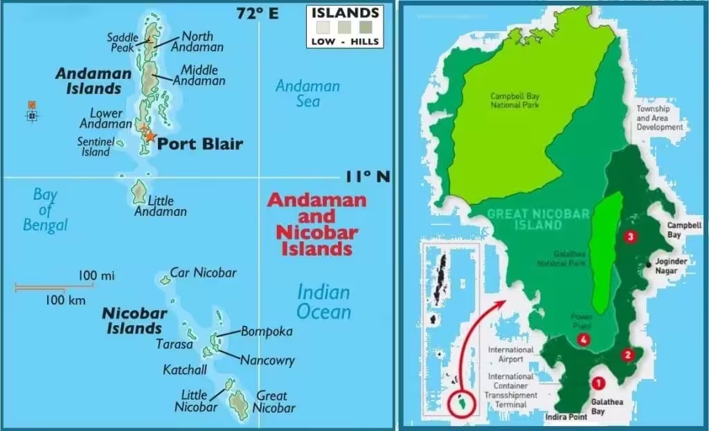
- The ₹72,000 crore -crore project involves building of an integrated international container transshipment terminal, a township, a civil- and military-use airport and a 450 MVA gas- and solar-based power plant.
- Spread over 166 sq km, it will require diversion of 130.75 sq km of forests, felling of over a million trees, as per official estimates.
- The Andaman and Nicobar Islands Integrated Development Corporation Limited (ANIIDCO) is implementing the project.
- The core aim has persisted since then — a port located near one of the world’s busiest international sea routes (the Malacca Strait) which will allow increased participation in global maritime trade.
What is the utility of the Great Nicobar Project?
- Infrastructure Development: The project aims to build a transshipment terminal (port), along with airport, township and power infrastructure on Great Nicobar Island.
- Efficient Sea trade: Because the island lies just ~90 km from the Strait of Malacca — one of the world’s busiest sea-routes — the port is expected to capture container traffic now routed via Colombo/Port Klang.
- Revenue and Employment: It is projected to generate significant economic benefits: e.g., government estimate of ~₹ 30,000 crore annual revenue by 2040 and large employment.
- Maritime Security: Strategically, the port + infrastructure strengthen India’s maritime reach in the Indian Ocean Region (IOR) and offer dual-use (civil + military) potential given the island’s location.
It also aligns with India’s “port-led development” vision, coastal economic zones and export-oriented growth.
What is the concept of port-led development in India?
Port-led development refers to using deep-sea ports as anchors of industrial, logistics, residential and export-oriented activity. It leverages coastal location, global shipping routes, container transshipment and hinterland connectivity. In India, this is pursued under schemes like Sagarmala (coastal economic zones, port modernisation) and inland linkages (rail/road) to maximise multiplier effects. The Great Nicobar project is a textbook example — a deep-water port close to major shipping lanes, master-planned township and infrastructure to make the island into a logistics hub/strategic node.
Why is there opposition?
The island of Great Nicobar is the southernmost tip of India and a part of the Andaman and Nicobar archipelago that comprises 600-odd islands. It is hilly and covered with lush rainforests that are sustained by around 3,500 mm of annual rainfall. The rainforests and beaches host numerous endangered and endemic species including the giant leatherback turtle, the Nicobar megapode, the Great Nicobar crake, the Nicobar crab-eating macaque, and the Nicobar tree shrew. It has an area of 910 sq km with mangroves and Pandan forests along its coast. The island is home to two tribal communities — the Shompen and the Nicobarese.
The mega project has been heavily criticised for its ecological costs and for potential violations of tribal rights.
- Ecological sensitivity and threat to endangered species: The transshipment terminal is expected to be developed at Galathea Bay, one of the world’s largest nesting sites for the giant leatherback turtle. Both this species and the Nicobar megapode are listed in Schedule I of the Wildlife (Protection Act), 1972 — the highest level of protection for wild animals under Indian law (numerous species, especially endemic ones, are likely yet to be documented in Great Nicobar given the limited number of surveys conducted so far).
- Legal issues: The island also falls under the Andaman & Nicobar (Protection of Aboriginal Tribes) Regulation, 1956 which safeguards tribe’s land. Over 853 sq km of 910 sq km is tribal reserve. Similarly, Tribal councils allege non-settlement of claims, Gram Sabha consent issues under FRA 2006. Further, many species in project area are Schedule I under WLPA 1972. Denotification of sanctuaries undermines protection.
- Displacement and loss of ancestral land: Some of the land classified as “uninhabited” in NITI Aayog’s plan is also part of the Great Nicobarese’s ancestral land. Since their post-tsunami resettlement, they have repeatedly sought to return to these lands — only to be met with administrative apathy. Today, the mega project also stands in the way of their demands to return.
- Health impacts on PVTGs: As for the Shompen, one of the biggest threats is disease. Since the Shompen have had little contact with the outside world, they haven’t yet developed immunity to infectious diseases that affect India’s general population. Some Shompen settlements also overlap with the areas the NITI Aayog has proposed to be used for the transshipment terminal.
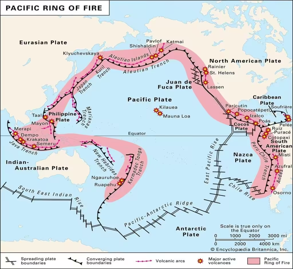
- Disaster vulnerability: Researchers who work on disaster management have also raised concerns that proponents of the mega project have failed to adequately assess earthquake risk. The Andaman and Nicobar archipelago is located in the “ring of fire”: a seismically active region that experiences several earthquakes throughout the year. The area is in category V: the geographical zone with the most seismic hazard.
What can be a way ahead?
- Adopt an integrated ‘island-wide sustainability framework’ where economic, ecological and tribal rights are balanced — use an ‘airshed’ or in this case an “island-ad threshold area” approach rather than ad-hoc approvals.
- Ensure full compliance with FRA (Gram Sabha consent), FCA and WLPA provisions before further land/forest diversion — strengthen independent monitoring and transparent data release.
- Harness green‐port technology, minimal footprint design and give priority to eco-tourism + low-impact logistics rather than large industrial township in ecologically sensitive zone.
- Institutionalise long-term environmental and disaster-risk assessment (earthquake/tsunami) and adaptive design (mangrove restoration, setback from shoreline).
- Expand tribal participation: Co-design development plans with Nicobarese & Shompen communities, ensure livelihoods and culture are safeguarded, and provide compensation + relocation only with consent.
- Explore phased development: Start with low-impact segments, evaluate ecological/tribal outcome, then scale only if safe and sustainable.
Integrate this project with broader blue economy, coastal shipping, island connectivity in a way that offsets environmental cost (e.g., shifting freight from land to sea corridors, carbon-negative logistics).