Stubble-Fire Monitoring: Beyond Satellite Fire Counts
Why in News?
CAQM asked ISRO to improve crop-residue-fire analysis by measuring burnt area and distinguishing fire intensity instead of relying mainly on event counts.
- Current monitoring uses a standard satellite protocol developed with State remote-sensing centres and agricultural researchers.
- Late-evening burning can occur after some polar-orbiting satellite passes.
- CAQM wants evidence that better reflects the scale and likely emissions of each burn, not only the number of detected points.
- A falling fire count can exaggerate progress if burn timing changes or one detected event covers a much larger field.
- Better measurement improves enforcement and source attribution but does not replace affordable residue-management alternatives for farmers.
UPSC Relevance
Prelims Relevance
- Polar-orbiting satellites observe locations during scheduled passes; geostationary satellites can watch the same broad region more continuously.
- A fire count records detected thermal anomalies, while burnt area estimates the land surface affected.
- Ground-truthing compares remote-sensing results with field observations.
- CAQM is a statutory body for the National Capital Region and adjoining areas.
- Crop-residue smoke is one contributor to seasonal particulate pollution, whose share varies by weather and period.
Mains Relevance
GS Paper 3
- Remote sensing in environmental governance
- Agricultural-residue management and seasonal air pollution
GS Paper 2
- Metrics, incentives and inter-State regulatory coordination
- Evidence quality in compliance claims
Essay
- A target improves governance only when the metric cannot be gamed.
Background and Context
What a Satellite Fire Count Actually Measures
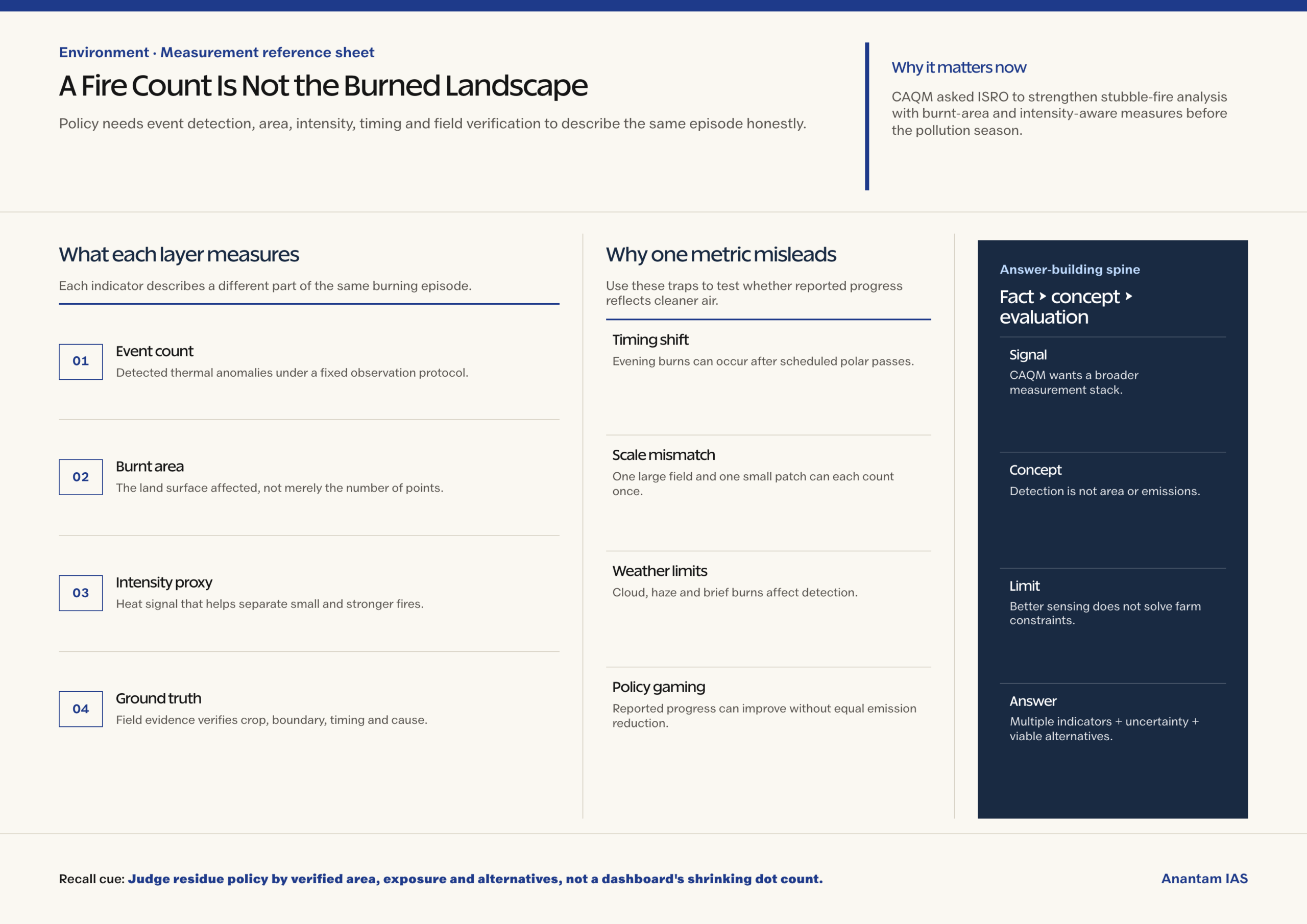
Remote sensing detects thermal signals, but a detected point is not a complete measure of area burned or pollution released.
- Sensors identify heat anomalies when energy from a fire is strong enough, sufficiently unobscured and present during the observation window.
- Cloud, haze, small fires, brief burns and the satellite’s timing can cause real events to be missed or recorded inconsistently.
- One fire point may represent a small patch or a large field, so equal counts do not necessarily mean equal residue or emissions.
- A lower count can reflect changed behaviour, changed weather, changed crop patterns or changed detection conditions rather than only cleaner practice.
- Consistent protocols remain useful for comparison, but interpretation must respect what the sensor and algorithm can actually observe.
Why Burnt Area and Intensity Improve the Picture
A better measurement stack combines several indicators because each answers a different question about the event and its consequences.
- Burnt area estimates spatial extent, helping distinguish many small burns from fewer large ones that affect more residue.
- Fire radiative measures can help classify intensity, though converting heat into emissions still requires fuel and combustion assumptions.
- Higher-frequency geostationary observations can reveal evening activity that scheduled polar passes may miss, with their own resolution trade-offs.
- Ground checks validate crop type, boundary, timing and whether a thermal signal came from residue burning rather than another heat source.
- Air-quality models then combine fire information with wind, boundary-layer height and other pollution sources to estimate contribution to regional particulate levels.
Measurement Reform Is Not Farm Policy
Accurate detection can diagnose the problem, but farmers still face a narrow field-clearance window and real machinery costs.
- Paddy residue must often be cleared quickly before wheat sowing, making burning a fast option when labour and machinery are unavailable.
- Enforcement based on weak metrics can punish unevenly, invite disputes and reward jurisdictions that optimise reported counts instead of reducing smoke.
- In-situ machines, decomposers, crop diversification and residue markets address different constraints; no single intervention suits every farm and residue type.
- State comparisons should publish method changes and uncertainty so apparent annual improvement is not mistaken for a fully comparable time series.
- The policy goal is lower exposure and sustainable residue use, not merely a visually reassuring dashboard with fewer red dots.
How Metrics Change Administrative Incentives
When governments are judged by one headline count, the measurement itself can redirect enforcement, reporting and farmer behaviour.
- Officials may prioritise visible count reduction over larger but less frequent burns, exposure outcomes or durable residue-use systems.
- Farmers can shift burning time when observation windows become predictable, producing statistical improvement without equivalent emission reduction.
- A balanced scorecard should reward verified area reduction, cleaner alternatives and lower exposure while penalising data gaps and unexplained method changes.
Way Forward
Use a Measurement Stack
- Combine event counts, burnt area, intensity indicators, geostationary observation and field verification under a documented protocol.
- Publish uncertainty, missed-observation windows and method revisions beside every seasonal comparison.
- Link enforcement to verified evidence while expanding timely machinery, residue markets and crop-transition support.
- Evaluate success through exposure, emissions and sustainable residue management rather than event counts alone.
Conclusion
- Moving beyond fire counts strengthens the evidence chain from remote sensing to air-quality action, especially when burn timing can evade scheduled observations.
- A strong answer should separate detection, burnt-area estimation, emission attribution and farm incentives instead of treating one satellite metric as the entire policy.
UPSC Practice Questions
Prelims MCQ 1
With reference to satellite monitoring of crop-residue fires, consider the following statements:
- A fire count is identical to burnt area.
- Polar-orbiting satellites observe a location during scheduled passes.
- Ground-truthing can validate remote-sensing classifications.
How many of the above statements are correct?
(a) Only one (b) Only two (c) All three (d) None
Answer: (b) Only two
Explanation:
Statements 2 and 3 are correct. Event count and burnt area are different measurements.
Prelims MCQ 2
Why can geostationary observation complement a polar-orbiting satellite for fire monitoring?
(a) It can observe a broad region more frequently (b) It needs no validation (c) It measures every pollutant directly (d) It eliminates cloud interference
Answer: (a) It can observe a broad region more frequently
Explanation:
Frequent observation can reveal timing changes, though resolution and atmospheric limitations remain.
UPSC Mains Questions
- Why can satellite fire counts become a misleading performance metric for crop-residue management? Suggest a better evidence framework.
- Accurate environmental monitoring is necessary but insufficient for behavioural change. Discuss with reference to stubble burning.
Sources: Hindustan Times and PIB, Ministry of Environment.
Frequently Asked Questions
What does a satellite fire count record?
It records detected thermal anomalies under a stated observation protocol, not the complete area burned or emissions released.
Why measure burnt area?
Burnt area distinguishes the spatial scale of events, preventing a few large burns from appearing equivalent to a few small ones.
What is ground-truthing?
It compares satellite classifications with field evidence to verify crop type, location, timing and the actual source of a signal.
Will better monitoring stop stubble burning?
Not alone. Farmers also need timely machinery, viable residue markets, suitable alternatives and fair enforcement based on verified evidence.