UN ‘Correct the Map Controversy’ and India’s Territorial Concerns
Why in News?
The UN General Assembly adopted the “Correct the Map” resolution on September 4, 2026, with 164 votes in favour, one against and six abstentions. The African-led initiative promotes maps that represent the relative sizes of continents more accurately. India voted in favour.
India has raised objections to the depiction of Arunachal Pradesh and Aksai Chin in a world map released by UN Geospatial on July 1.
| UPSC Relevance: GS-1 Geography: Map projections and Geography; GS-2 International Relations: India’s foreign policy and sovereignty Prelims: Correct the Map initiative, Mercator map |
What is the “Correct the Map” initiative?
- Introduced by Togo on behalf of the African Group, the initiative challenges the widespread use of maps that exaggerate high-latitude landmasses and diminish the apparent size of equatorial regions.
- It encourages wider use of equal-area projections, particularly Equal Earth, where comparing continental sizes is important. Its relevance extends to educational materials, public communication and geographical literacy.
What is the problem with the existing map?
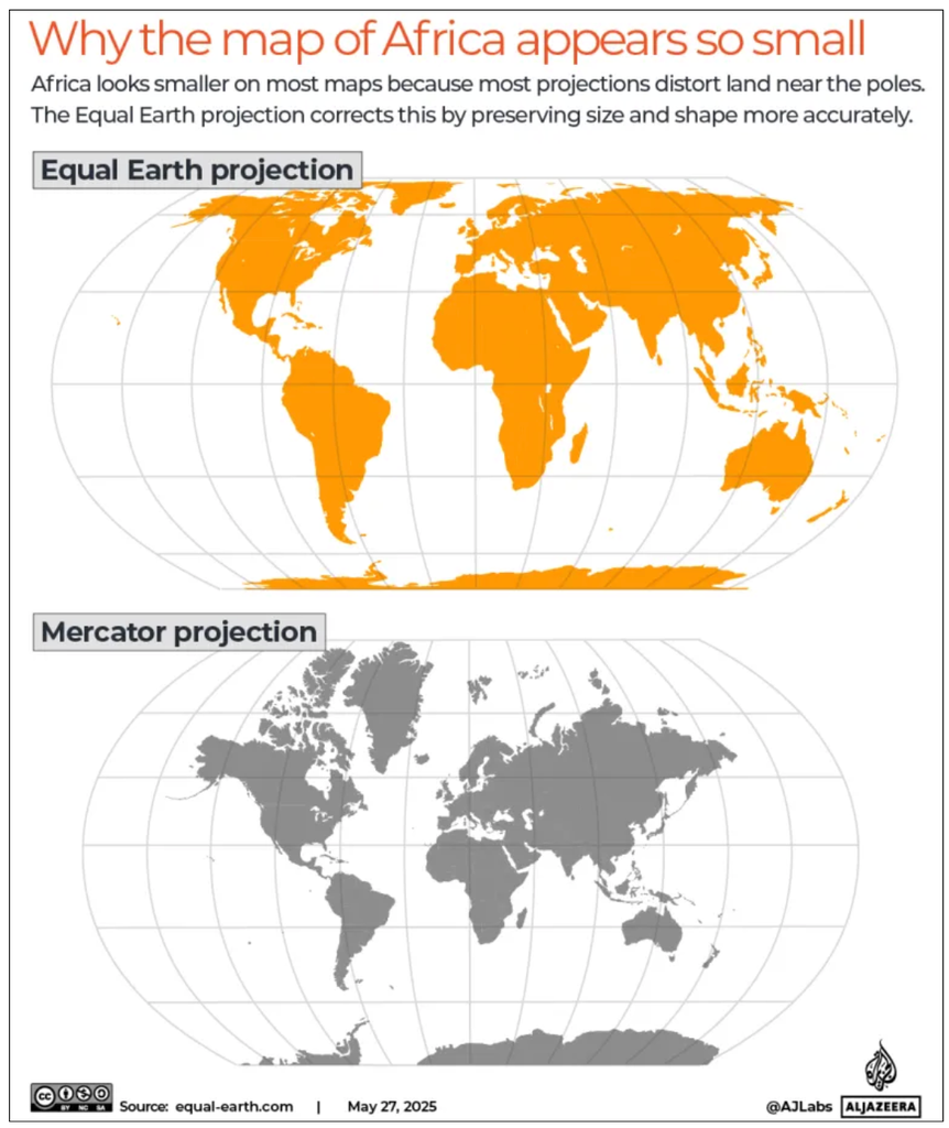
The principal target is the Mercator projection, a familiar rectangular world map. Mercator’s main limitation is area distortion:
- Regions farther from the Equator appear increasingly enlarged.
- Greenland, northern Europe, Canada and Russia consequently occupy disproportionately large areas on the map.
- Africa and other lower-latitude regions appear smaller relative to those inflated regions.
- Distortion occurs towards both poles, rather than exclusively in the Northern Hemisphere.
E.g., Greenland can appear comparable in size to Africa on a Mercator map, although Africa is approximately 14 times larger.
The concern is therefore about misleading visual proportions, not incorrect measurements of countries’ actual areas.
Why was the Mercator map designed this way?
- It was developed primarily for navigation. Flemish cartographer Gerardus Mercator introduced the projection in 1569. Its crucial advantage is that a route maintaining a constant compass bearing appears as a straight line. This made plotting sailing courses easier.
- On a globe, meridians converge towards the poles. On the Mercator map, they remain parallel. Thus, the Mercator map preserves local angles, while sacrificing accurate area representation.
Why cannot we make a completely accurate flat world map?
- A map projection mathematically transfers Earth’s curved surface onto a plane. Imagine flattening an orange peel: it must stretch, tear or change shape. Similarly, no flat world map can simultaneously preserve Areas, Shapes, Distances and Directions, all at once.
- An equal-area map improves area comparisons but still distorts other properties.
What changes does Equal Earth offer?
- The Equal Earth projection, developed in 2018 by Bojan Šavrič, Tom Patterson and Bernhard Jenny, is an equal-area, pseudocylindrical projection intended for world maps.
Its principal features are:
- Correct relative areas: Landmasses occupy space proportional to their actual surface areas.
- Reduced visual exaggeration of high latitudes: Africa and other lower-latitude regions regain their proper proportions relative to Greenland and northern landmasses.
- A familiar overall appearance: Its design was inspired by Robinson, but unlike Robinson, it preserves relative areas.
- Continued distortion of other properties: It does not preserve every shape, distance or direction accurately.
What exactly is India’s objection to the UN map?
According to the supplied report, the July 1 UN Geospatial map:
- Depicted Arunachal Pradesh and Aksai Chin between Indian and Chinese claim lines.
- Omitted explanatory labels identifying those lines, which earlier UN maps had used.
- Explained the dotted Line of Control between India and Pakistan, while leaving the India-China claim-line depiction insufficiently explained.
India favours correcting misleading comparisons of continental size. India requires its sovereign territory (including Jammu and Kashmir and Ladakh) to be depicted in accordance with its official map.
Does the resolution change international boundaries?
It does not provide a basis for concluding that borders have changed. The initiative concerns geographical literacy and continental proportions, without affecting sovereignty, territorial status or boundary delimitation.
A map may influence public perceptions, but changing its projection does not resolve a territorial dispute.