Wayanad X-Band Doppler Weather Radar and Local Early Warning
Why in News?
The India Meteorological Department said on August 6, 2026 that an X-band Doppler Weather Radar would be commissioned at Pulpally in Kerala’s Wayanad district by December 2026.
- Pazhassi Raja College at Pulpally has provided land for the radar, which will be manned and operated by IMD’s technical and meteorological personnel.
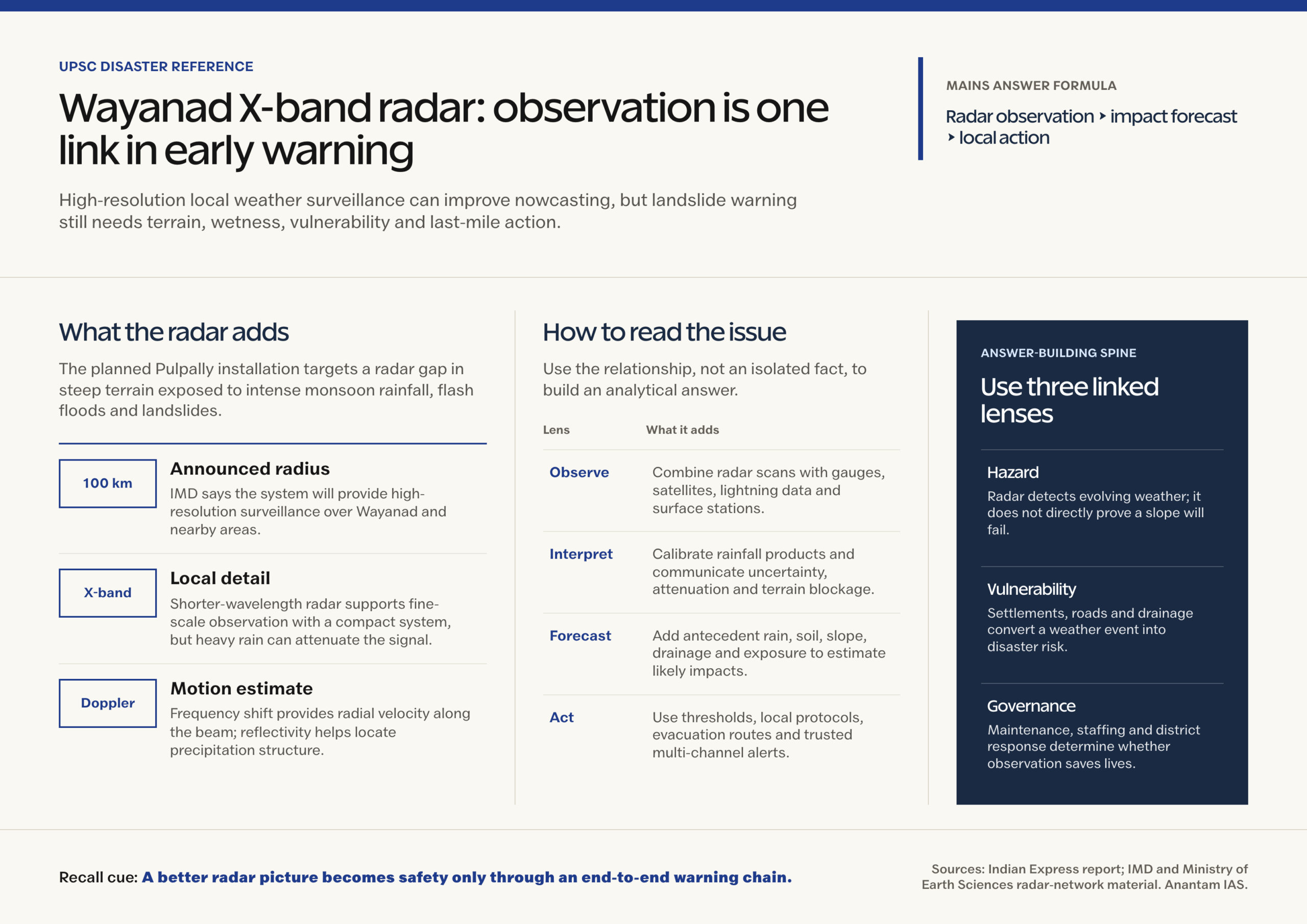
- IMD told The Indian Express that the system would provide high-resolution weather surveillance over a radius of 100 km, benefiting Wayanad and nearby areas.
- The planned radar is meant to improve the timeliness and accuracy of forecasts and warnings supplied to the district administration, disaster-management authority and public.
- A March 2025 parliamentary reply had already listed Wayanad among the tentative locations for new X-band DWRs, placing the project within a wider expansion of India’s radar network.
- The announcement follows repeated disasters in the district, including the July 2024 landslides near Meppadi. That context explains the urgency, but a weather radar should not be described as a stand-alone landslide-prediction machine.
- Wayanad lies in the Western Ghats, where steep slopes, complex terrain and strong orographic influence can produce sharp local variations in rainfall that are difficult to represent through sparse observations alone.
- A radar provides frequent, spatially continuous observations of precipitation systems between surface stations. This is valuable for nowcasting, the very short-range forecasting of weather already developing or likely to develop soon.
- Early warning becomes useful only when observations flow into forecasts, impact thresholds, clear institutional decisions and last-mile communication. Better detection does not automatically produce timely evacuation.
UPSC Relevance
Prelims Relevance
- A Doppler Weather Radar sends microwave pulses and analyses returned signals to locate precipitation and estimate characteristics such as reflectivity and radial motion.
- The Doppler effect is the change in observed frequency caused by relative motion between the source and the observer; weather radar uses it to estimate motion toward or away from the radar along the beam.
- Radar reflectivity is related to the strength of the returned signal and helps forecasters identify the location and intensity structure of precipitation.
- Radial velocity represents motion along the radar beam. A single radar does not directly provide the complete three-dimensional wind vector at every point.
- X-band systems use a shorter wavelength than C-band and S-band weather radars and are suited to detailed surveillance over a comparatively local area.
- IMD stated that the Pulpally radar would cover a 100 km radius; this is the announced operational coverage for this project, not a universal range for every X-band system.
Mains Relevance
GS Paper 3
- Explain how dense radar coverage can strengthen early warning systems for cloudbursts, flash floods, thunderstorms and rainfall-triggered slope hazards in complex terrain.
- Evaluate the full warning chain from observation to forecast, impact assessment, communication and protective action, rather than treating equipment procurement as the final outcome.
GS Paper 1
- Relate the Western Ghats’ orographic rainfall, steep relief, drainage response and slope instability to Wayanad’s exposure to high-impact weather.
- Distinguish between a meteorological hazard, a geomorphological process and a disaster shaped by exposure and vulnerability.
Essay
- Technology reduces disaster risk only when institutions can translate better knowledge into trusted and timely action.
Background and Context
What a Doppler Weather Radar Measures
A DWR is an active remote-sensing instrument: it transmits microwave energy and processes the signal scattered back by hydrometeors such as raindrops, snow particles or hail.
- The strength of the return is expressed through reflectivity products, which help reveal precipitation location, structure and relative intensity.
- The frequency shift in the return provides radial velocity, allowing forecasters to examine motion along the radar beam and detect organised circulation or convergence signatures.
- Repeated scans at different elevation angles build a volume view of the atmosphere. Derived products can support rainfall estimation, storm tracking and short-range warning decisions.
- Radar is an indirect measurement. Beam geometry, terrain blockage, distance, calibration, anomalous propagation and signal attenuation can affect what is observed, so products require expert interpretation and comparison with other instruments.
Why X-Band Fits a Local High-Resolution Role
Weather-radar bands involve a practical trade-off among wavelength, spatial detail, antenna size, useful range and susceptibility to signal loss in heavy precipitation.
- An X-band radar operates at a shorter wavelength than commonly used C-band and S-band systems. It can support fine-scale observations with a relatively compact installation.
- Its strength is local surveillance of rapidly evolving weather, which matches the need to observe small, intense rain systems over Wayanad and adjoining areas.
- Shorter-wavelength signals are more affected by attenuation as they pass through heavy precipitation. That limitation must be managed through calibration, processing, network design and interpretation.
- The 100 km figure reported for Pulpally is a project-specific coverage radius. A candidate should avoid memorising simplistic universal ranges for radar bands because specifications and operational products vary.
Why Wayanad Needs Denser Observation
Wayanad’s risk is produced by the interaction of intense monsoon weather with mountainous terrain and vulnerable settlements and infrastructure.
- Moist air forced to rise across the Western Ghats can enhance rainfall through orographic uplift, while the distribution of rainfall may change sharply across ridges, valleys and short distances.
- Steep catchments can convert heavy rain into fast runoff, raising flash-flood risk. Saturated or weakened slopes may fail when rainfall adds pore-water pressure or removes support.
- A surface rain gauge measures conditions at one location. Radar adds the spatial pattern and movement of precipitation, helping identify where intense cells are forming and how they evolve.
- The new radar should complement the existing S-band DWR at Kochi and C-band DWR at Thiruvananthapuram, along with satellites, gauges, automatic weather stations, lightning data and numerical models.
From Weather Detection to Landslide Warning
A stronger weather picture is one input into a multi-hazard early-warning system, not proof that a particular slope will fail.
- A hazard forecast estimates a physical event such as intense rainfall. An impact-based warning asks what that rainfall could do to people, roads, rivers, slopes and essential services in a particular place.
- Operational landslide warning needs rainfall intensity and duration, antecedent wetness, soil and geological information, slope inventories, drainage conditions and records of past failures.
- Thresholds should be calibrated for local terrain and then tested against events. A district-wide rainfall threshold can miss micro-scale risk or trigger too many false alarms.
- Warnings must specify the threatened area, expected impact, confidence, time window and recommended action. A technically correct alert that arrives late or uses vague language has limited protective value.
Way Forward
Build a Multi-Sensor Wayanad Warning System
- Fuse radar products with rain gauges, automatic weather stations, satellite estimates, lightning observations, river levels and soil-moisture information on one operational dashboard.
- Map radar visibility and terrain blockage, retain redundant sensors in weak-coverage zones and conduct routine comparisons between radar estimates and ground observations.
- Feed quality-controlled observations into nowcasting and numerical prediction systems while ensuring that forecasters can explain uncertainty and override automated outputs when evidence demands it.
Conclusion
- The Pulpally X-band radar can close an important observational gap by showing the structure and movement of local rain systems with greater detail.
- Its real test will come after commissioning: whether reliable radar data are combined with ground evidence, local thresholds, trusted communication and rehearsed action.
UPSC Practice Questions
Prelims MCQ 1
With reference to Doppler Weather Radar, consider the following statements:
- Radar reflectivity can help identify the location and intensity structure of precipitation.
- Doppler radial velocity directly provides the complete three-dimensional wind vector at every observed point.
- X-band radar generally uses a shorter wavelength than C-band and S-band weather radar.
How many of the above statements are correct?
(a) Only one (b) Only two (c) All three (d) None
Answer: (b) Only two
Explanation:
Statements 1 and 3 are correct. Reflectivity describes returned signal strength associated with precipitation structure, and X-band has the shorter wavelength. Radial velocity measures motion along the radar beam, not the full three-dimensional wind vector by itself.
Prelims MCQ 2
Which one of the following best describes the role of the planned X-band radar at Pulpally?
(a) It will directly predict the failure of every landslide-prone slope (b) It will replace rain gauges and satellite observations across Kerala (c) It will provide high-resolution local weather surveillance to strengthen forecasting and early warning (d) It will measure earthquake waves beneath the Western Ghats
Answer: (c) It will provide high-resolution local weather surveillance to strengthen forecasting and early warning
Explanation:
IMD has described the project as a 100 km-radius high-resolution weather-surveillance system. It can strengthen rainfall monitoring and nowcasting, but landslide warning still needs terrain, soil, hydrological and exposure information.
UPSC Mains Questions
- A weather radar is an observing instrument, while an early-warning system is an institutional chain. Examine this distinction with reference to the planned X-band Doppler Weather Radar in Wayanad. (250 words)
- Discuss how high-resolution weather surveillance can reduce disaster risk in the Western Ghats. What technological and governance limitations must be addressed? (250 words)
Sources: The Indian Express and Ministry of Earth Sciences, Parliament Question on Locations for New Radars.
Frequently Asked Questions
What is the Wayanad X-band Doppler Weather Radar project?
IMD plans to commission an X-band DWR at Pulpally in Wayanad by December 2026. It is expected to provide high-resolution weather surveillance over a 100 km radius and strengthen forecasts and early warnings for Wayanad and neighbouring areas.
Why is an X-band radar useful in Wayanad?
X-band radar is suited to detailed monitoring over a local area. In Wayanad’s complex Western Ghats terrain, it can help forecasters see the structure and movement of intense rain systems that may trigger flash floods or contribute to slope instability.
Can the radar predict landslides by itself?
No. It can improve rainfall observation and very short-range weather forecasts. A landslide warning also requires antecedent rainfall, soil moisture, geology, slope condition, drainage, land-use and exposure data, plus locally tested thresholds and field reporting.
What does Doppler mean in weather radar?
Doppler refers to the frequency shift in a returned radar signal caused by motion. It allows forecasters to estimate radial motion toward or away from the radar, while reflectivity products help describe precipitation location and structure.
What is nowcasting?
Nowcasting is the immediate to very short-range forecasting of weather, based heavily on frequently updated observations. Radar, satellite, lightning and surface data help forecasters track rapidly developing storms and issue location-specific warnings with useful lead time.