Master Plan for Urban Areas in India: Importance, Challenges and Reform (UPSC Indian Society)
A master plan is the statutory blueprint that decides how a city grows, yet about 65% of India's towns have none. Here is what it is, why the gap exists, and how to fix it.
Stand at the edge of almost any fast-growing Indian town and you can read its planning failure in the skyline. A four-storey building leans over a lane too narrow for a fire engine, a stormwater drain has been built over by a row of shops, and a colony of a few thousand families has come up on what a map still calls farmland. None of this was an accident of nature. It is what happens when a city grows without a binding plan that says where roads, water, housing and green space are allowed to go.
That binding plan is the master plan, and the uncomfortable fact is that most Indian towns do not have a valid one. NITI Aayog’s 2021 report on urban planning capacity found that about 65 per cent of the country’s 7,933 urban settlements function without any master plan at all. With India’s cities projected to hold around 600 million people by 2036, and to generate close to 70 per cent of GDP, the absence of statutory spatial planning has quietly become the single biggest cause of India’s most visible urban failures, from Bengaluru’s floods to the unauthorised colonies that ring every metro.
What a Master Plan Actually Is
Let’s define the thing precisely, because the term gets used loosely. A master plan, sometimes called a development plan or comprehensive development plan, is a statutory land-use blueprint for a delineated planning area. It is prepared by an urban local body or an urban development authority under the state’s Town and Country Planning Act, and once it is notified in the official gazette it carries the force of law. After that, you cannot legally build a factory in a residential zone or a tower on land marked for a park. The plan, not the builder, decides what goes where.
A proper master plan does far more than colour a map. It projects population and economy 20 to 25 years out, then works backwards to allocate land for housing, commerce, industry, transport, public amenities and open space, and it fixes the intensity of use through zoning rules and the Floor Space Index, the cap on how much floor area you can build on a plot. It is meant to be a living document, revised and re-notified once its horizon expires. So a master plan is really three things at once: a forecast, a contract with citizens about how their city will grow, and the legal yardstick against which every building permit is judged.
The power to prepare these plans rests with the states, not the Centre. Urban development and town planning sit on the State List, and most states have enacted their own Town and Country Planning Acts to enable it. The professional and technical scaffolding is national, though: the Town and Country Planning Organisation, an apex technical arm under the Ministry of Housing and Urban Affairs, advises on planning standards, while state town-and-country-planning departments and development authorities like the Delhi Development Authority or the Bangalore Development Authority do the actual drafting and enforcement. A separate concept worth keeping straight is the difference between a master plan and a development plan in everyday use: a master plan is the broad, long-horizon land-use vision for the whole planning area, while detailed development plans, zonal plans or local area plans break that vision down to the neighbourhood and street level. The hierarchy only works when the higher plan actually exists. The rapid in-migration that loads pressure onto this system is traced in our explainer on https://anantamias.com/urbanization/.
The Planning Gap: How Big the Hole Is
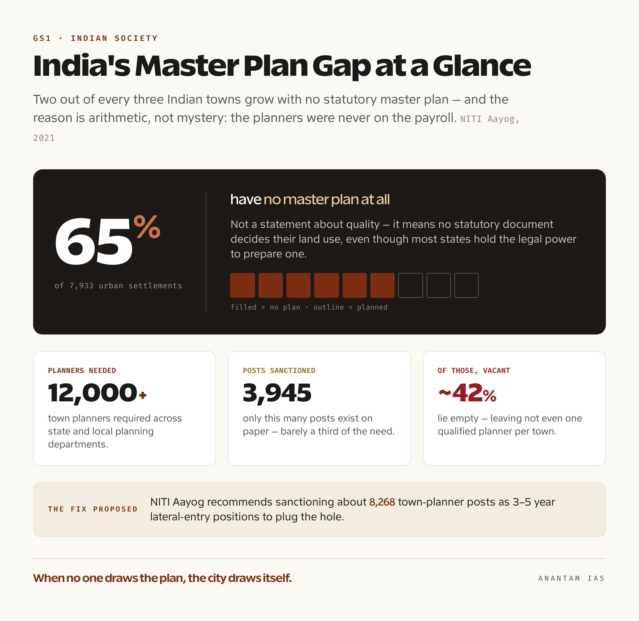
Now the scale of the problem, because the headline number is genuinely startling. NITI Aayog’s 2021 report, prepared with the Town and Country Planning Organisation and the National Institute of Urban Affairs, found that roughly 65 per cent of the 7,933 urban settlements in India have no master plan. That is not a statement about quality. It means two out of every three towns are growing with no statutory document deciding their land use at all, even though most states have the legal authority to prepare one.
Behind that gap sits a human-resource crisis that the same report laid bare. India needs more than 12,000 town planners in its state and local planning departments, but only about 3,945 posts are sanctioned, and roughly 42 per cent of even those lie vacant. NITI Aayog put it starkly: the country does not have even one qualified planner per town. To plug the hole it recommended sanctioning around 8,268 town-planner posts as lateral-entry positions for three to five years. When the people who are supposed to draw the plans simply are not on the payroll, the planning gap is not a mystery; it is arithmetic.
The consequences are exactly what you would predict. NITI Aayog noted that the failure to prepare and implement master plans drives haphazard construction and worsens congestion, pollution and flooding. Where no plan binds growth, the city fills the gap itself, with unauthorised colonies, encroached drains and buildings that violate norms nobody is enforcing. The deprivation this produces is the subject of our note on https://anantamias.com/urban-poverty/.
Why the Plans Fail Even Where They Exist
But having a master plan on paper is not the same as having a planned city, and Delhi proves it better than any town that lacks one. The capital has had a master plan since 1962, yet the draft Master Plan of Delhi 2041, prepared by the Delhi Development Authority and released for public comment in 2021, drew around 33,000 objections and still awaits final notification by the Ministry of Housing and Urban Affairs. The plan in force, MPD-2021, expired years ago, so every land transaction in DDA-governed Delhi is still judged against a blueprint whose horizon has already passed. A plan that cannot be revised on time stops describing the city and starts lagging it.
The gap between the plan and the reality on the ground is the deeper failure. Delhi’s own draft for 2041 was the first to map the roughly 1,700 unauthorised colonies that already house a large share of the city, an admission that growth had run far ahead of the document meant to guide it. Schemes like PM-UDAY, which confers ownership rights in some 1,731 of those colonies, are essentially after-the-fact regularisation, the state catching up with development that the master plan never sanctioned. When regularising the unplanned becomes routine policy, the plan has lost its authority to shape the city in advance.
Three structural reasons explain why plans fail even when they exist. First, capacity: with a 12,000-plus planner shortfall, plans are outdated before they are notified and barely monitored afterwards. Second, data: most plans still project from the 2011 Census because the next decadal census has been delayed, so they are built on a decade-old picture of population and land use. Third, enforcement and finance: urban local bodies are chronically resource-starved, with own-revenue often well below their spending, so they lack both the muscle to enforce zoning and the money to build the infrastructure the plan promises. A plan with no enforcement is a suggestion, and a city treats it as one.
The Reform Push: GIS Plans, AMRUT 2.0 and the 74th Amendment
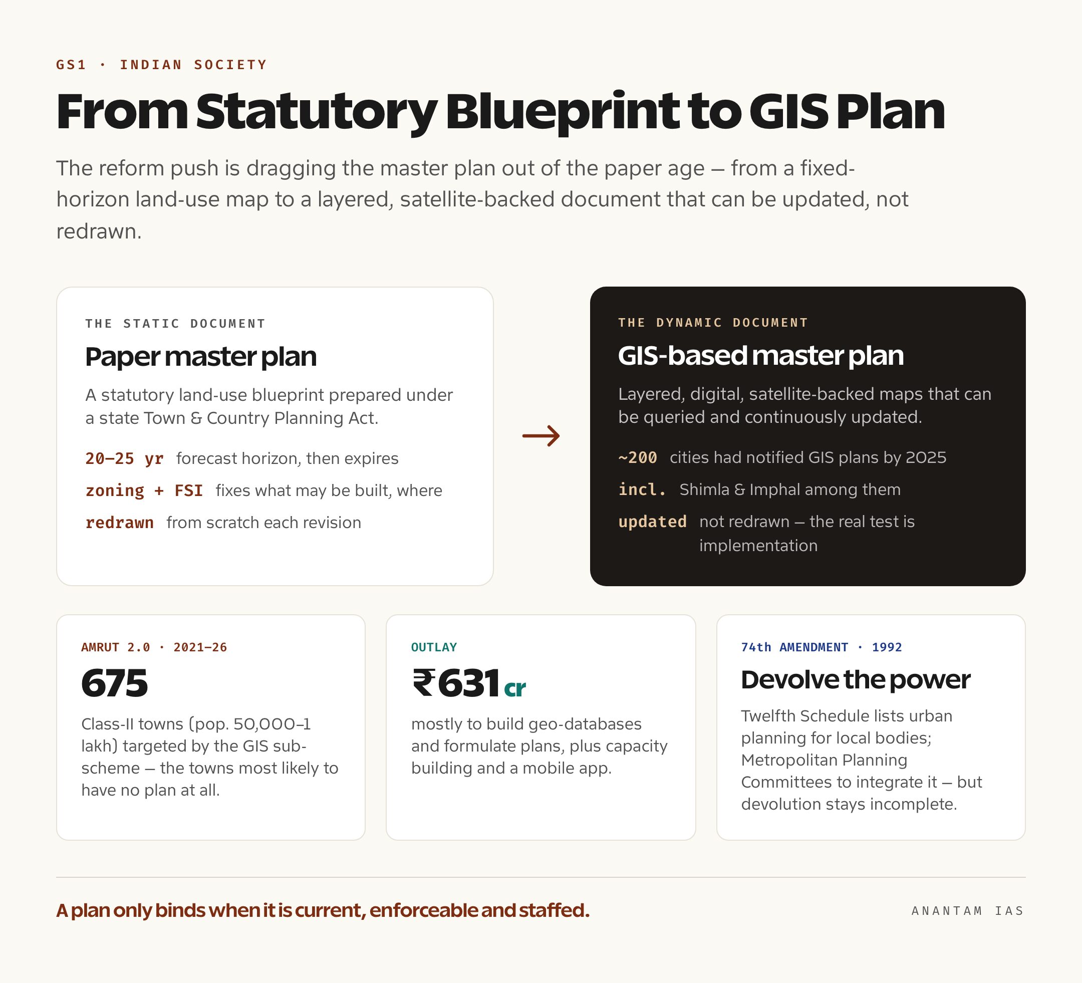
The reform response has the right diagnosis and is now moving on three fronts. The first is to drag the master plan out of the paper age. Under AMRUT, the Ministry of Housing and Urban Affairs pushed cities to prepare GIS-based master plans, layered, digital, satellite-backed maps that can be queried and updated rather than redrawn from scratch. By 2025, around 200 cities, including Shimla and Imphal, had notified GIS-based plans, with more than a hundred others at draft or baseline-map stage, though the agencies themselves admit the real test is implementation, not preparation.
AMRUT 2.0, the 2021 phase running to 2025-26, then added a dedicated sub-scheme to formulate GIS-based master plans for 675 Class-II towns, those with populations between 50,000 and one lakh, with the scope extending to smaller statutory towns in hilly and north-eastern states. The sub-scheme carries an outlay of about Rs 631 crore, the bulk of it for creating geo-databases and formulating the plans, plus capacity building and a mobile application, and the Centre has been onboarding states and towns in tranches. The logic is sound: the towns with no plan at all are overwhelmingly the smaller ones, and that is exactly where this sub-scheme aims. It also tries to standardise quality, so a small town’s plan is no longer a one-off effort that lapses the moment its single contractor leaves.
The second front is institutional and constitutional, and this is where the 74th Amendment matters. The 1992 amendment created elected urban local bodies and, through the Twelfth Schedule, listed urban planning including town planning among the functions meant to be devolved to them. It also envisaged District Planning Committees and Metropolitan Planning Committees to integrate spatial planning across a metropolis. But that devolution remains incomplete: in most states real planning power still sits with state-controlled development authorities rather than elected councils, and Metropolitan Planning Committees are sparsely constituted or barely functional. NITI Aayog’s reform agenda pushes for upgrading state planning laws, a statutory body to set national standards for the profession, and a shift from static land-use zoning toward dynamic spatial planning that integrates economy, mobility and climate.
The Way Forward
So what would actually close the gap? The short answer is that India must treat planning capacity as infrastructure in its own right, not an afterthought. The most immediate fix is people: fast-tracking the thousands of vacant and lateral-entry planner posts NITI Aayog recommended, expanding postgraduate planning seats, and easing the constraint that today leaves most towns without a single qualified planner. No reform survives contact with a planning office that has no planners in it.
The rest follows from there. Every town should be brought under a current, statutorily notified plan through a time-bound, AMRUT-2.0-backed programme, and those plans should be dynamic and GIS-based so they can be revised continuously instead of expiring on a calendar. Plans must integrate, not criminalise, the informal city, offering tenure security and service upgrades to unauthorised settlements rather than waiting to regularise them later. They need a real climate lens, with flood, heat and water-stress mapping built in, after the lesson of repeated urban floods. And the 74th Amendment’s promise has to be honoured by genuinely empowering elected local bodies and Metropolitan Planning Committees, backed by stronger municipal finances so a plan can actually be enforced and funded. Comparators help here: Singapore’s Urban Redevelopment Authority refreshes an integrated land-use and transport plan on a fixed cycle, while Germany’s building code gives spatial plans firm statutory teeth. A master plan only works when it is current, enforceable, and prepared by people the city has actually hired.
For Your Mains Answer
Master plans sit at the intersection of three papers, which is what makes the topic so useful. It maps to GS Paper 1 under urbanisation and the problems of Indian society, to GS Paper 2 under the 74th Amendment, local self-government and centre-state-local devolution, and to GS Paper 3 under infrastructure, inclusive growth and disaster and climate resilience. Treat it as a governance-and-capacity question, not just a geography one, and you can deploy it across all three.
How to Build the Answer
Open with the gap, not the definition. Lead with NITI Aayog’s finding that about 65 per cent of 7,933 towns have no master plan, then define what a master plan is and why a missing one matters. Move outward in widening circles: the statutory nature of the plan, the capacity and data deficits behind the gap, the plan-versus-reality failure (Delhi MPD-2041, unauthorised colonies), the reform push (GIS plans, AMRUT 2.0, the 74th Amendment), and a forward-looking close on capacity and devolution. That arc, problem, concept, causes, current reforms, way forward, fits almost any urban-governance prompt.
Common Mistakes to Avoid
Don’t confuse the master plan with a smart-city scheme or a housing scheme; it is the statutory land-use document underneath all of them. Don’t blame “rapid urbanisation” alone, which reads as a slogan; the sharper point is the capacity and statutory deficit that lets growth go unguided. Don’t forget the federal angle: planning is a state subject, so reform runs through state Town and Country Planning Acts and the 74th Amendment, not a single central order. And don’t list problems with no reform to match them.
A Compact Answer Spine
Master plan as statutory land-use blueprint under state Town and Country Planning Acts → NITI Aayog 2021: ~65% of 7,933 towns have none, 12,000-plus planner shortfall → consequence: haphazard growth, floods, unauthorised colonies → plans fail even where they exist (Delhi MPD-2041 unnotified, regularisation as routine) → reforms: GIS plans, AMRUT 2.0 sub-scheme for 675 Class-II towns, 74th Amendment devolution → way forward: planning capacity as infrastructure, dynamic plans, integrate the informal city, climate lens.
Diagram or Flowchart Idea
Draw a simple vertical hierarchy: at the top a “Master Plan (20-25 year horizon, statutory)”, branching down to “Zonal / Development Plans”, then to “Local Area Plans / Building Permits”. Beside it, place three pressure arrows pushing in, labelled “capacity deficit”, “data gap (Census delay)” and “weak enforcement / ULB finances”. The contrast between the neat hierarchy and the arrows breaking it captures the whole argument in one frame.
A Balanced-Conclusion Line
A confident close: India does not lack the legal idea of the master plan, it lacks the planners, the data and the devolved authority to make the idea bind, and closing that capacity gap is now as much an infrastructure priority as roads or water.
How to Use Data Without Cramming
Carry three anchors and no more: about 65 per cent of 7,933 towns without a master plan (NITI Aayog 2021), a 12,000-plus shortfall against roughly 3,945 sanctioned planner posts, and AMRUT 2.0’s GIS sub-scheme for 675 Class-II towns. Attribute them in-line, the way an examiner reads as command of the subject, and let one live example, Delhi’s unnotified MPD-2041, do the work of ten statistics.
FAQ
What is a master plan for an urban area? A master plan is the statutory land-use blueprint for a city’s delineated planning area, prepared under the state’s Town and Country Planning Act and usually spanning a 20 to 25 year horizon. Once notified in the gazette it has the force of law, fixing where housing, commerce, industry, transport and open space can go, and the zoning and Floor Space Index rules that govern building intensity.
How many Indian towns lack a master plan? NITI Aayog’s 2021 report on urban planning capacity found that about 65 per cent of India’s 7,933 urban settlements have no master plan at all, even though most states have the legal power to prepare one. The report tied this to a severe shortage of town planners, with India needing more than 12,000 against roughly 3,945 sanctioned posts.
What is the AMRUT 2.0 GIS-based master plan scheme? AMRUT 2.0 includes a dedicated sub-scheme to formulate GIS-based, digital master plans for 675 Class-II towns with populations between 50,000 and one lakh, plus smaller statutory towns in hilly and north-eastern states. It carries an outlay of about Rs 631 crore and aims to replace static paper maps with layered, satellite-backed plans that can be updated rather than redrawn.
Why does the Delhi Master Plan 2041 matter? The draft Master Plan of Delhi 2041, released by the Delhi Development Authority in 2021, drew around 33,000 objections and still awaits final notification, so the expired MPD-2021 remains in force. It illustrates the wider problem that even cities with a long planning tradition struggle to revise plans on time, and that growth, such as Delhi’s roughly 1,700 unauthorised colonies, routinely runs ahead of the plan meant to guide it.
Practice Questions
Prelims MCQs
- With reference to master plans for urban areas in India, consider the following statements: 1) The power to prepare and notify master plans rests primarily with state governments under their Town and Country Planning Acts. 2) A master plan typically has a long-term horizon of about 20 to 25 years. 3) Once notified, a master plan has the force of law.
Which of the statements given above are correct?
(a) 1 and 2 only
(b) 2 and 3 only
(c) 1 and 3 only
(d) 1, 2 and 3.
Answer: (d) All three are correct: planning is a state subject, plans run for roughly 20-25 years, and a notified plan is legally binding. - The 2021 NITI Aayog report on urban planning capacity is best known for which finding?
(a) About 65 per cent of India’s urban settlements have no master plan
(b) India’s urban population has already crossed 50 per cent
(c) All metropolitan cities have functioning Metropolitan Planning Committees
(d) Master plans are prepared by the central government.
Answer: (a) The report found that around 65 per cent of the 7,933 urban settlements function without any master plan. - The AMRUT 2.0 sub-scheme on formulation of GIS-based master plans is primarily aimed at which category of towns?
(a) The six metropolitan cities
(b) Class-II towns with populations of 50,000 to one lakh
(c) Only state capitals
(d) Towns with populations above one million.
Answer: (b) The sub-scheme targets Class-II towns of 50,000-99,999 population, extending to smaller statutory towns in hilly and north-eastern states. - Which of the following is correctly matched with the 74th Constitutional Amendment Act?
(a) Twelfth Schedule, which lists urban local body functions including urban planning
(b) Tenth Schedule, anti-defection
(c) Ninth Schedule, land reform laws
(d) Eleventh Schedule, panchayat functions.
Answer: (a) The 74th Amendment added the Twelfth Schedule, listing functions such as urban planning and town planning for urban local bodies. - Consider the following regarding India’s town-planner shortage as flagged by NITI Aayog in 2021: 1) India needs more than 12,000 town planners in its public planning departments. 2) A large share of even the sanctioned planner posts lie vacant.
Which of the statements is/are correct?
(a) 1 only
(b) 2 only
(c) Both 1 and 2
(d) Neither 1 nor 2.
Answer: (c) India needs over 12,000 planners against roughly 3,945 sanctioned posts, of which about 42 per cent were vacant.
Mains Practice Questions
- “Most Indian towns are growing without a statutory master plan, and that gap is the quiet cause of India’s most visible urban failures.” Critically examine. (15 marks, 250 words)
- Discuss the role of master planning in managing India’s urban transition. What reforms does the NITI Aayog 2021 report on urban planning capacity recommend? (15 marks, 250 words)
- “A master plan is only as strong as the capacity that prepares and enforces it.” In light of India’s town-planner shortage and weak municipal finances, suggest a way forward. (15 marks, 250 words)
- The 74th Constitutional Amendment promised to devolve urban planning to elected local bodies, yet real planning power still rests with state authorities. Analyse this gap and its consequences for spatial planning. (15 marks, 250 words)
- Examine how GIS-based and dynamic master plans, supported by AMRUT 2.0, can address the limitations of traditional static land-use plans in Indian cities. (10 marks, 150 words)