Brahmaputra River System: Origin, Tributaries, and Significance
Brahmaputra river system explained: Tibet origin as Yarlung Tsangpo, Indian tributaries, Majuli island, floods, hydro projects, and UPSC geography.
The Brahmaputra river system is one of the largest river systems in Asia and the primary river of northeast India. Known as the Yarlung Tsangpo in Tibet, Siang / Dihang in Arunachal Pradesh, and Brahmaputra in Assam, the river flows across China, India, and Bangladesh, finally merging with the Ganga and Meghna to form the world's largest delta. It is the only major river in India referred to in masculine gender and is central to Assam's geography, economy, and culture. This guide covers the Brahmaputra's source, course, tributaries, hydrology, and its strategic and ecological significance.
Origin and Course
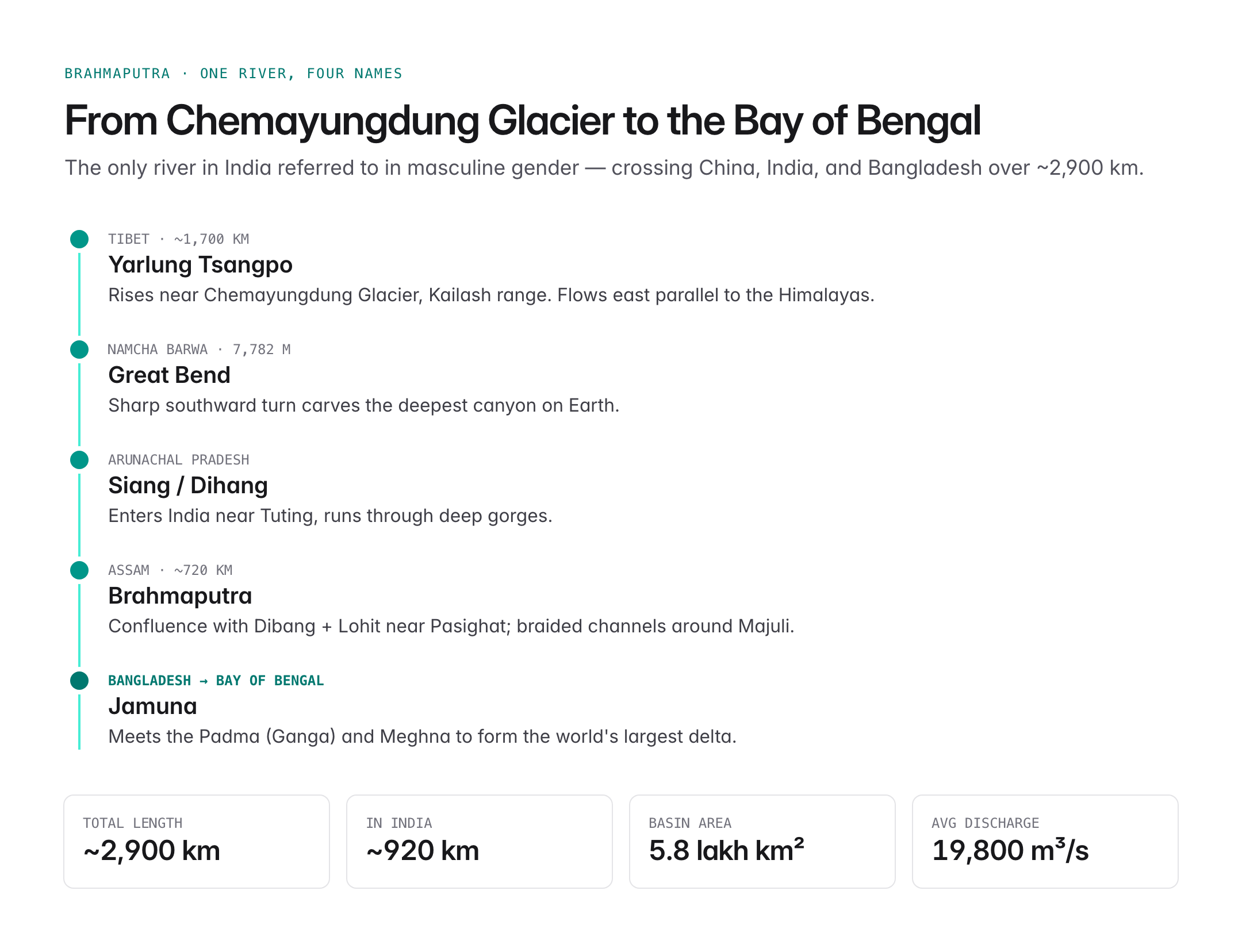
The Brahmaputra rises near the Chemayungdung Glacier on the northern side of the Himalayas in Kailash range, Tibet, close to Lake Manasarovar.

Oxford Student Atlas for India — 7th Edition
- 160 pages, Oxford University Press, the current edition
- India-focused thematic maps: physical, political, rivers, climate, soils, vegetation, plus world maps
- Made for UPSC and state PSC map work; slim enough to stay open beside the textbook
- Tibet (Yarlung Tsangpo): Flows east for about 1,700 km parallel to the Himalayas.
- Great Bend: Near Namcha Barwa (7,782 m), the river makes a spectacular southward turn, carving the deepest canyon on Earth.
- Arunachal Pradesh (Siang / Dihang): Enters India near Tuting and flows as the Siang through deep gorges.
- Assam (Brahmaputra): After meeting the Dibang and Lohit near Pasighat, it becomes the Brahmaputra and flows westward across Assam for about 720 km.
- Bangladesh (Jamuna): Enters Bangladesh near Dhubri, known as the Jamuna, before joining the Padma (Ganga) and finally the Meghna to form the Ganga–Brahmaputra–Meghna delta emptying into the Bay of Bengal.
Total length: about 2,900 km, of which roughly 920 km lies in India.
Major Tributaries
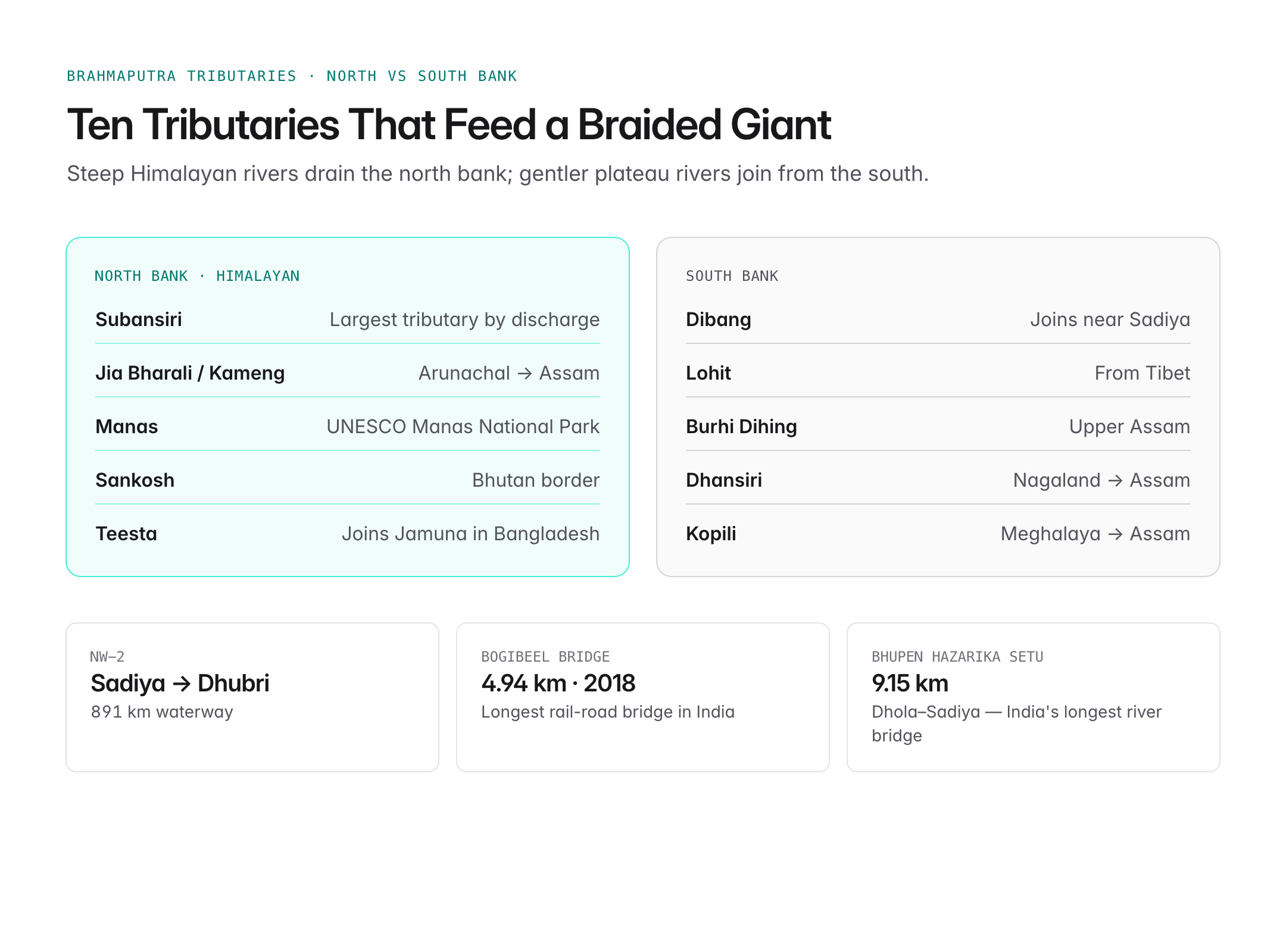
The Brahmaputra has numerous tributaries, with steep-gradient rivers on the north bank from the Himalayas and gentler ones from the south.
North bank (Himalayan) tributaries:
- Subansiri (largest tributary by discharge)
- Jia Bharali / Kameng
- Manas
- Sankosh
- Teesta (joins the Jamuna in Bangladesh)
South bank tributaries:
- Dibang
- Lohit
- Burhi Dihing
- Dhansiri
- Kopili
| Tributary | Bank | Notable feature |
|---|---|---|
| Subansiri | North | Largest, trans-Himalayan |
| Dibang | South | Joins near Sadiya |
| Lohit | South | Also from Tibet |
| Manas | North | UNESCO Manas National Park |
| Teesta | North | Joins in Bangladesh |
Hydrological Characteristics
- Basin area: About 580,000 sq km, of which roughly 194,000 sq km lies in India.
- The Brahmaputra has one of the highest discharges of any river in the world (annual average ~19,800 cubic metres per second at its mouth).
- It is a braided river in Assam, often splitting into multiple channels around shifting sand bars.
- Carries huge sediment loads from the young, unstable Himalayas.
- Hosts Majuli, one of the world's largest river islands (Assam).
Assam Floods
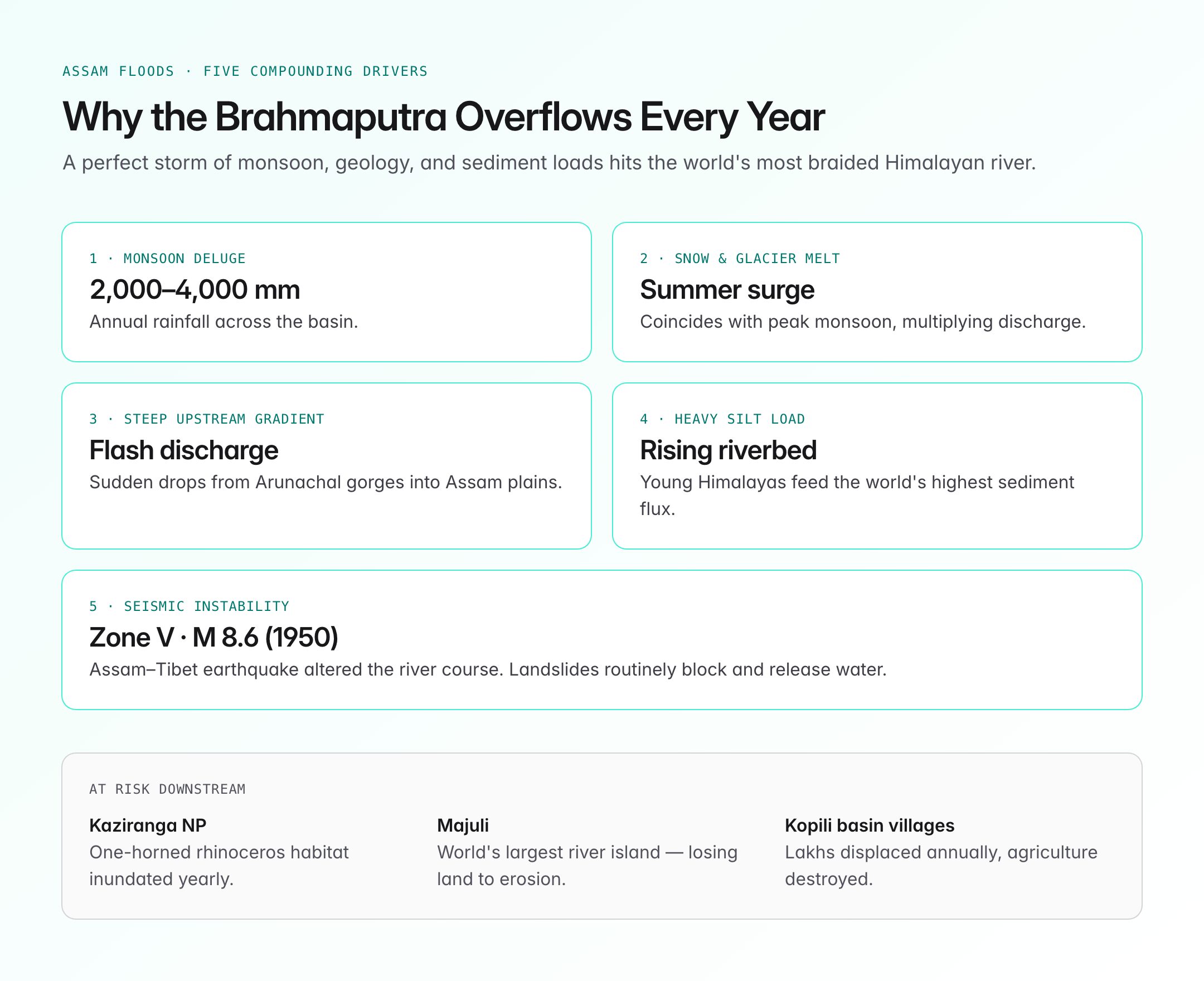
The Brahmaputra is infamous for annual flooding in Assam. Key reasons:
- Heavy monsoon rainfall in the basin (2,000–4,000 mm annually).
- Snow and glacier melt in summer.
- Steep gradient upstream causing sudden discharge surges.
- High silt load raising the riverbed.
- Tectonic activity – the region lies in Seismic Zone V, prone to landslides that block and release water suddenly.
Floods displace lakhs of people every year, causing significant damage to agriculture, infrastructure, and the Kaziranga National Park, home to the one-horned rhinoceros.
Hydropower and Strategic Significance
The Brahmaputra basin has enormous hydroelectric potential (estimated over 60,000 MW in Arunachal Pradesh alone).
- Major Indian projects include the Ranganadi, Kameng, and the under-construction Subansiri Lower hydroelectric project (2,000 MW) and plans for the Dibang Multipurpose Project.
- China has constructed the Zangmu Dam (operational 2015) on the Yarlung Tsangpo and announced a medog / Motuo mega-dam project downstream of Namcha Barwa.
- The Brahmaputra is not part of the Indus Waters Treaty; there is no comprehensive water-sharing treaty with China. India and China share hydrological data under MoUs on flood-season discharge.
- India is building the Siang Upper Multipurpose Project partly as a strategic reservoir to buffer flow variations from Chinese upstream dams.
Ecological and Cultural Importance
- Majuli in Assam is the world's largest river island and a centre of Vaishnavite satras founded by Sankardeva.
- Kaziranga National Park and Manas National Park, both UNESCO World Heritage Sites, lie in the basin.
- River dolphins (Gangetic dolphin), the national aquatic animal, are found in the Brahmaputra.
- The river is culturally central to Assamese identity, celebrated in Bihu songs and folk literature.
- Ferry transport is vital; NW-2 (National Waterway 2) uses the Brahmaputra from Sadiya to Dhubri (891 km).
Inland Waterways and Connectivity
- The Brahmaputra is National Waterway 2, declared under the National Waterways Act, 2016.
- The India-Bangladesh Protocol on Inland Water Transit and Trade enables cargo movement between Kolkata and Assam via Bangladesh.
- The Bogibeel Bridge (4.94 km, inaugurated 2018) is India's longest rail-road combined bridge and a strategic connector across the Brahmaputra.
- The Dhola–Sadiya / Bhupen Hazarika Setu (9.15 km) is India's longest river bridge.
Environmental Concerns
- Climate change: Glacial retreat in the Tibetan Plateau threatens long-term flow.
- Seismicity: The 1950 Assam-Tibet earthquake (M 8.6) altered the river course and raised the bed by several metres.
- Upstream Chinese dams create concerns about altered flow and sediment regimes.
- Encroachment on wetlands and deforestation worsen floods.
- Erosion has taken significant land away from Majuli.
UPSC Relevance
Prelims focus:
- Source: Chemayungdung Glacier (Mansarovar region), Tibet.
- Names along the course: Yarlung Tsangpo → Siang / Dihang → Brahmaputra → Jamuna.
- Namcha Barwa – site of the Great Bend.
- National Waterway 2 – Sadiya to Dhubri, 891 km.
- Majuli – world's largest river island; Kaziranga, Manas – basin national parks.
Mains GS angle (GS Paper I – Geography; GS Paper III – Environment and Infrastructure):
- Brahmaputra flood management and disaster mitigation in Assam.
- India–China transboundary water issues and strategic implications of upstream dams.
- Hydropower potential vs ecological and seismic risks in Arunachal Pradesh.
- Inland water transport as a driver of Northeast development.
Sample PYQ angle: UPSC has asked about drainage patterns, Himalayan rivers, and transboundary river issues. Expect questions on the Brahmaputra's tributaries, Majuli erosion, or India-China water diplomacy.