Yarmouk River: The Jordan Tributary That Sits at the Heart of West Asian Water Politics
The Yarmouk River doesn’t get the headlines that the Nile or the Tigris or even the Jordan itself attracts. But for anyone tracking water politics in West Asia, the Yarmouk River is where the real action sits. It’s the largest tributary of the Jordan River, it forms a chunk of the natural boundary between Syria and Jordan, and three countries (Israel, Jordan, Syria) have spent seventy years negotiating, fighting, and quietly redrawing how its water gets divided.
For UPSC location-in-news questions, the Yarmouk is exactly the kind of physical feature that shows up under “boundaries between countries” or “tributaries of major world rivers.” But the deeper story is more interesting. The Yarmouk basin is where you can see the Johnston Plan of 1953, the unbuilt dreams of Arab regional cooperation, the Israel-Jordan peace treaty of 1994, and the slow climate-driven decline of a river that everyone needs and nobody can fully control.
This piece walks through the geography, the historical context, the disputes, and why the Yarmouk River keeps reappearing in news cycles even though most coverage barely acknowledges it.
Quick Facts at a Glance
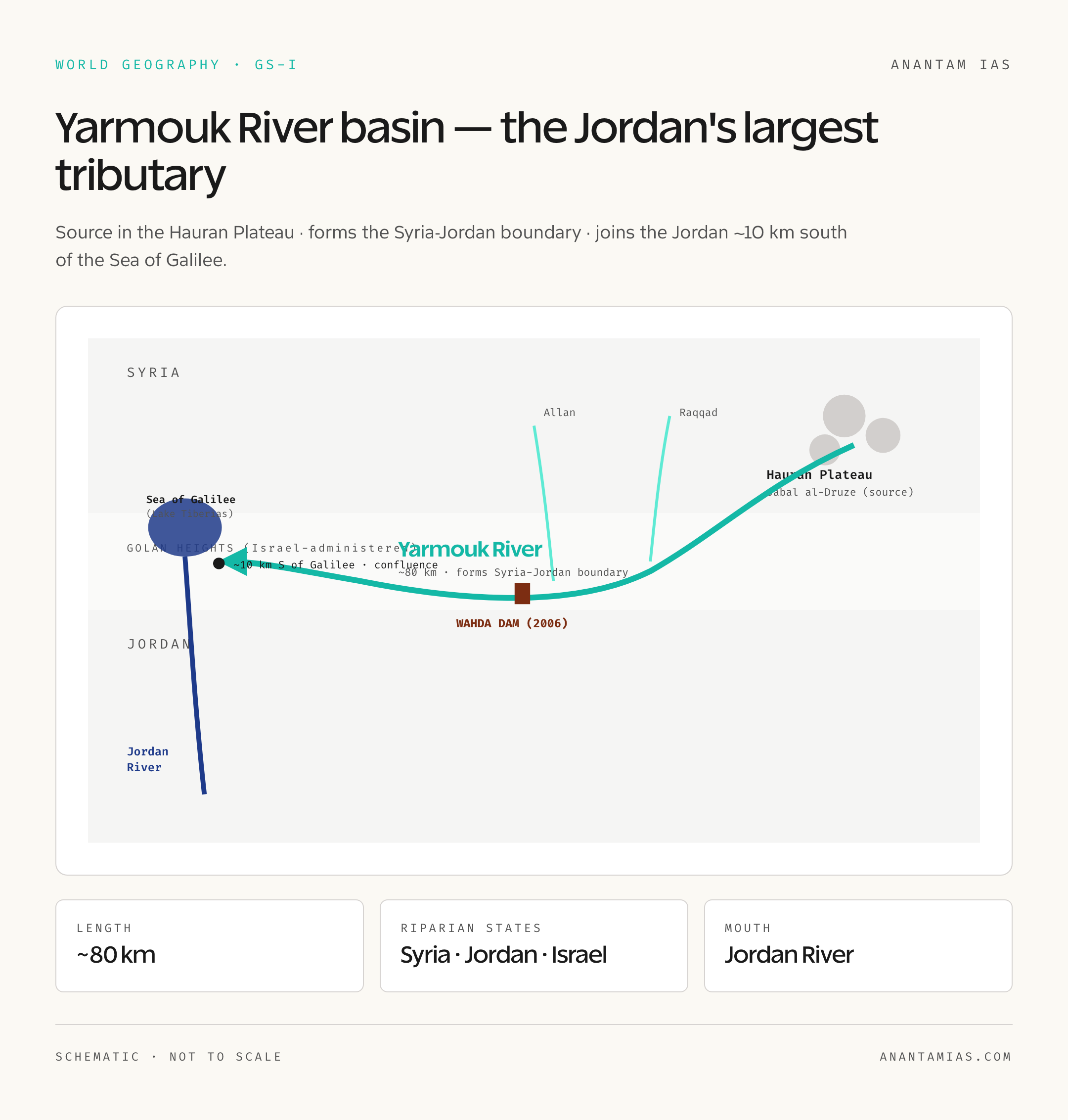
- River: Yarmouk River (Arabic: Nahr al-Yarmouk)
- Length: Approximately 80 km (some estimates extend to 100+ km including headwaters)
- Source: Hauran Plateau, southwestern Syria (Jabal al-Druze region)
- Mouth: Joins the Jordan River about 10 km south of the Sea of Galilee (Lake Tiberias)
- Major tributary of: Jordan River (its largest tributary by discharge)
- Forms boundary between: Syria and Jordan (lower course); also touches Israeli-controlled Golan Heights
- Riparian states: Syria, Jordan, Israel (with Palestinian water rights claims)
- Key dam: Wahda Dam (Unity Dam), commissioned 2006, joint Syria-Jordan project
- Key historical instrument: Johnston Plan (1953, unratified)
- Modern instrument: Israel-Jordan Treaty of Peace (1994), Article 6 on water
What Just Happened: Why the Yarmouk Is Back in News
The Yarmouk basin re-entered news cycles in late April 2026 because of renewed concerns about reduced flows reaching Jordan. Climate stress, upstream Syrian abstractions during the post-conflict reconstruction phase, and Jordan’s chronic water deficit have combined to push the issue back onto the diplomatic table. There are also fresh discussions about the long-stalled Red Sea-Dead Sea conveyance project, which was supposed to compensate for declining Jordan-Yarmouk flows.
For aspirants, the news angle is less important than the underlying geography and the institutional architecture that governs the river. Whenever the Yarmouk River appears in a question, the framing will be either physical (where does it flow, what does it border) or strategic (who shares it, under which treaty, with what disputes).
Background and Historical Context
The Yarmouk Through History
The Yarmouk valley has been strategic terrain since antiquity. The Battle of Yarmouk in 636 CE, where Arab forces decisively defeated the Byzantine Empire, took place along this very river and reshaped the political map of West Asia for centuries. The valley was a natural corridor between the Levantine coast and the Hauran’s grain belt, and control of its water has always meant control of agricultural productivity in a parched region.
In the modern era, the Yarmouk’s hydrological importance was first systematically mapped during the Mandate period. By the 1950s, with the new state of Israel, the kingdom of Jordan, and Syria all dependent on the same water budget, the United States stepped in. Eric Johnston, a special envoy of President Eisenhower, drafted what became known as the Johnston Plan in 1953-1955.
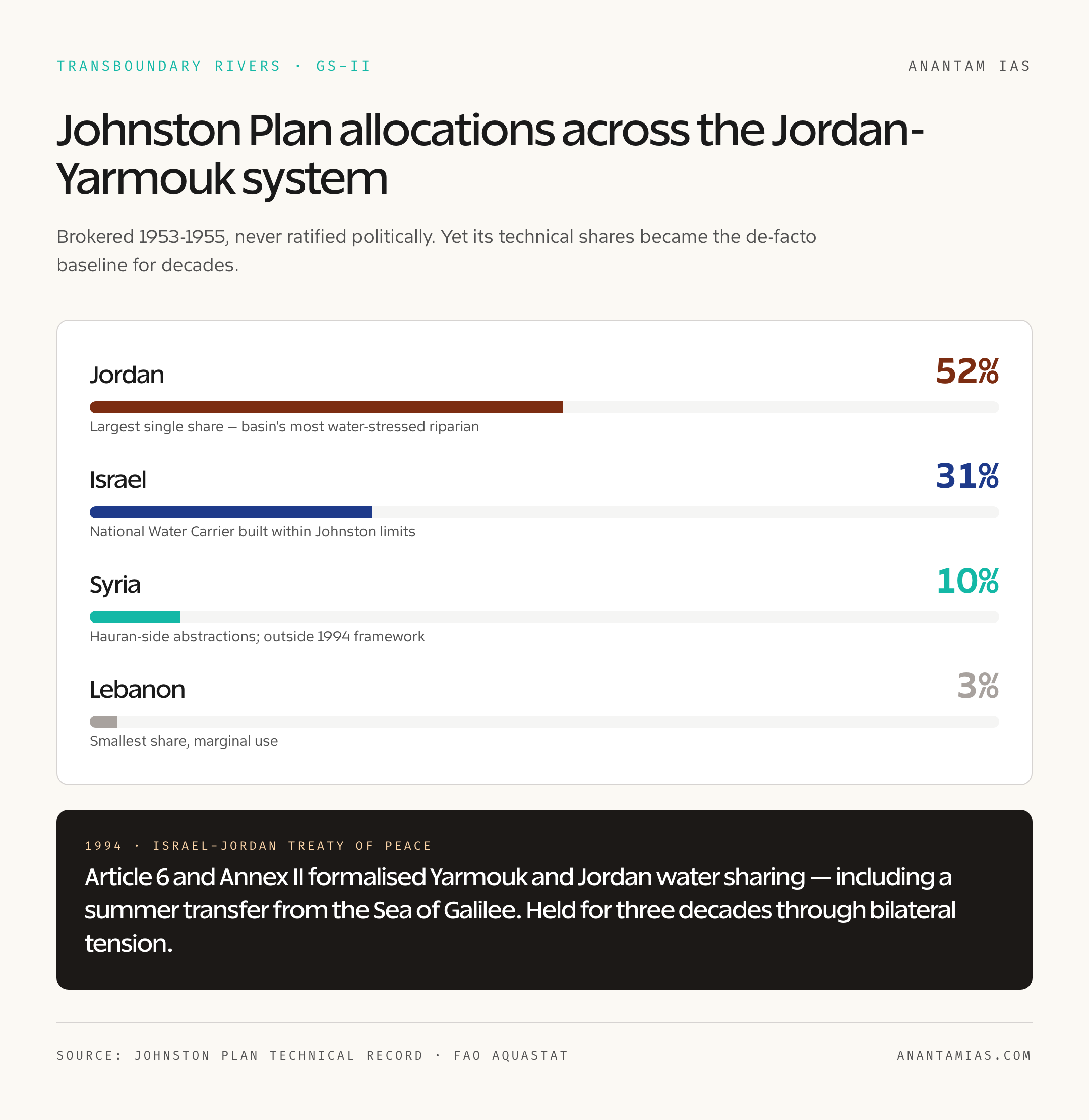
The Johnston Plan proposed allocations across the Jordan-Yarmouk system: roughly 52 percent of usable water to Jordan, 31 percent to Israel, 10 percent to Syria, and 3 percent to Lebanon (with adjustments). Engineers on all sides accepted the technical work. Politicians did not. The Arab League refused to formally endorse a plan that implied recognition of Israel, and the agreement was never ratified. But, and this is the crucial point, all parties largely respected the technical allocations on the ground for decades.
Geographic Setting and Key Features
The Yarmouk River rises in the volcanic Hauran Plateau of southwestern Syria, draining the slopes of Jabal al-Druze. From there it flows generally west and southwest, picking up tributaries from both the Syrian and Jordanian sides. The lower course of the river forms a natural boundary between Syria to the north and Jordan to the south, a stretch where the river is carved into a deep, dramatic gorge.
The Yarmouk briefly touches the edge of the Israeli-controlled Golan Heights before joining the Jordan River about 10 kilometers south of the Sea of Galilee (also called Lake Tiberias or Kinneret in Hebrew). The confluence is the largest single addition of water to the Jordan River along its entire course, which is why the Yarmouk is described as the Jordan’s principal tributary.
Key tributaries: The Raqqad (from Syria), the Allan, and several smaller wadis feed into the Yarmouk. In the highland sections, springs and karst aquifers contribute significantly, especially during the dry summer months when surface flow declines.
Climate: The basin sits in a Mediterranean-to-semi-arid transition zone. Most rainfall arrives between November and March, with summer flows dependent on baseflow from springs. Average annual rainfall ranges from over 600 mm in the Hauran headwaters down to 200-300 mm in the lower basin.
Discharge: Historical mean annual flow at the Yarmouk’s mouth was estimated at around 400-500 million cubic meters per year. Recent decades have seen this drop substantially because of upstream abstractions and climate change, with some recent estimates putting actual flow below 200 million cubic meters per year as per latest available data.
Why It Matters
Three reasons. First, the Yarmouk is Jordan’s single most important surface water source. Jordan is one of the most water-scarce countries in the world by per capita availability, and any reduction in Yarmouk flow translates directly into agricultural stress and urban supply problems in Amman and Irbid.
Second, the Yarmouk is one of the few transboundary rivers in West Asia where a functioning, if imperfect, water-sharing regime exists between Israel and Jordan. The 1994 peace treaty includes specific water provisions for the Yarmouk and the Jordan, and these have largely held even during periods of bilateral tension. That makes the river an unusual case study in cooperative water management in a conflict-prone region.
Third, the basin connects to the larger Israeli-Palestinian water rights debate, which is a recurring UPSC theme under international relations and global commons.
Detailed Analysis
The Johnston Plan and Its Long Shadow
The Johnston Plan of 1953-1955 deserves its own paragraph because it shaped everything that followed. Although unratified, the plan’s technical allocations became the de facto baseline for water use in the basin. Israel built the National Water Carrier in the 1960s within roughly the limits Johnston had proposed. Jordan and Syria likewise structured their abstractions within the implicit framework. The plan failed politically but succeeded technocratically, which is itself a useful lesson about how international cooperation can work in pieces.
The Wahda (Unity) Dam
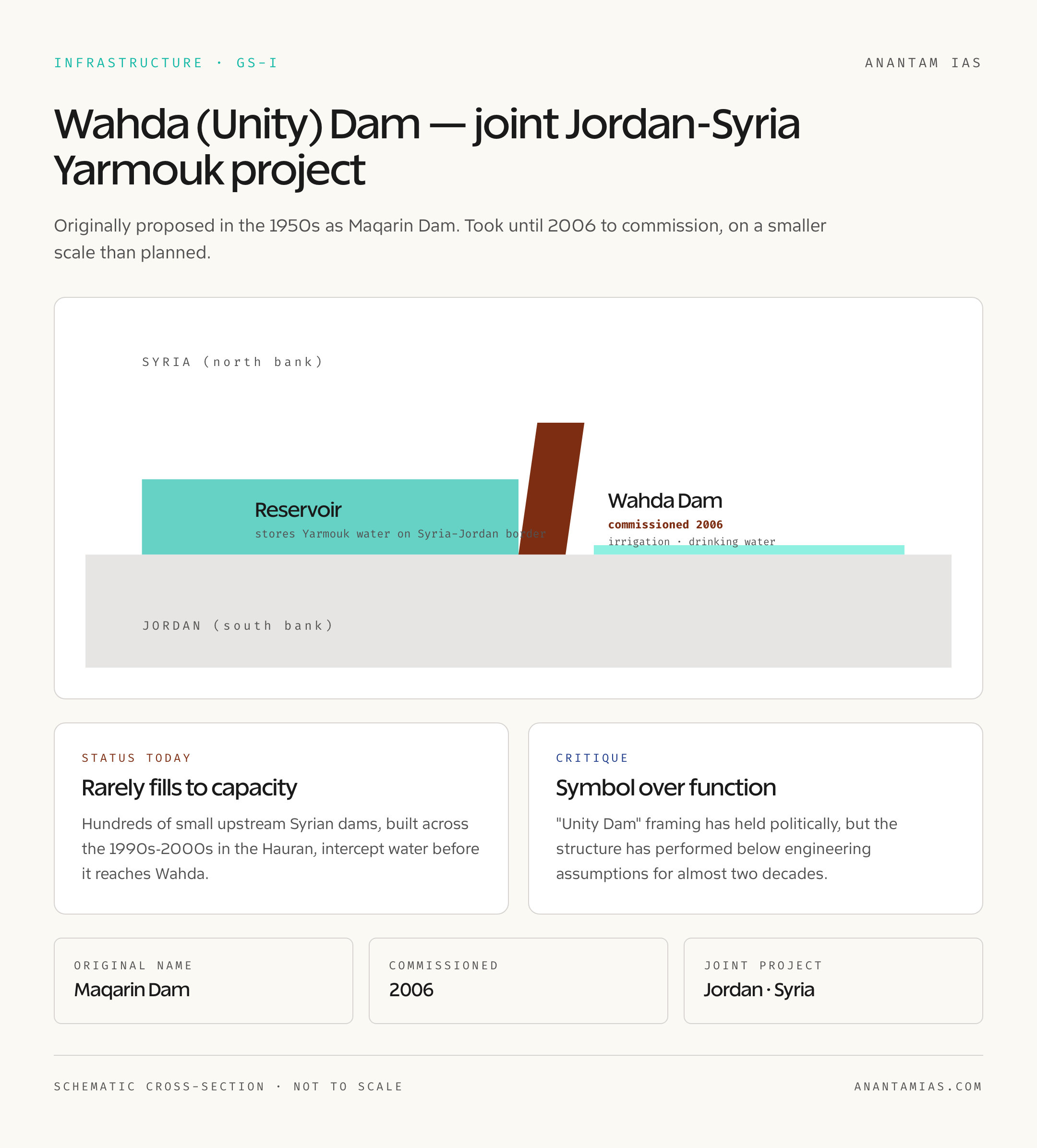
The Wahda Dam, also called the Unity Dam, was a flagship Jordan-Syria joint project. Originally proposed in the 1950s as the Maqarin Dam, it took until 2006 for an actual structure to be commissioned, on a smaller scale than originally planned. The Wahda Dam stores Yarmouk water on the Jordan-Syria border and is meant to provide irrigation and drinking water for both countries.
In practice, the dam has rarely filled to capacity. Upstream Syrian abstractions, especially through hundreds of small dams built during the 1990s and 2000s in the Hauran region, have meant that less water reaches the Wahda site than the engineering studies assumed. This has been a chronic source of tension between Jordan and Syria, even setting aside the larger geopolitical complications of the Syrian civil war.
The 1994 Israel-Jordan Peace Treaty
Article 6 and Annex II of the treaty between Israel and Jordan formalized water sharing on the Yarmouk and Jordan. Israel undertook to transfer specific quantities of water to Jordan, including a summer transfer from the Sea of Galilee. The treaty has held for over three decades, even during politically fraught moments, which is genuinely unusual for a transboundary water arrangement in this region.
Climate Change and Declining Flows
Climate models for the eastern Mediterranean project warming and drying over the rest of this century. Yarmouk flows have already declined substantially compared to mid-20th century baselines. The combination of climate stress, population growth in Jordan, refugee inflows from Syria and Iraq, and continued upstream abstractions creates a structural water crisis that no single bilateral arrangement can fully solve.
For more on transboundary water themes, our explainer on the Cauvery river covers similar inter-state allocation challenges in an Indian context.
Comparative Perspective: Other Transboundary Rivers in News
The Yarmouk River sits in a global category of disputed transboundary rivers worth comparing. The Indus (India-Pakistan) operates under the Indus Waters Treaty of 1960, brokered by the World Bank, and is structurally similar to the Yarmouk in that it survives even when bilateral political relations don’t. The Mekong (China and downstream Southeast Asian states) is governed by a much weaker institutional framework and shows what happens when no binding allocation exists. The Nile (Ethiopia, Sudan, Egypt) is currently in active dispute over the Grand Ethiopian Renaissance Dam.
Within India, our piece on the Ken River discusses interlinking and inter-state coordination, though the political stakes are obviously different.
Challenges and Critiques
The Yarmouk basin faces three structural problems. First, no single comprehensive treaty includes all riparian states. The 1994 treaty binds Israel and Jordan but Syria is outside the framework. Second, monitoring and enforcement are weak, with limited shared data on actual abstractions in the Syrian highland portion of the basin. Third, climate change is shrinking the resource itself, which means even faithful adherence to existing allocations may not deliver enough water.
Critics also point out that the Wahda Dam, billed as a unity project, has functioned more as a symbol than as a working piece of infrastructure given the chronic water shortfalls upstream of it.
UPSC Prelims Pointers
- The Yarmouk River is the largest tributary of the Jordan River
- Source: Hauran Plateau in southwestern Syria
- Forms part of the boundary between Syria (north) and Jordan (south)
- Joins the Jordan River about 10 km south of the Sea of Galilee
- Riparian states: Syria, Jordan, Israel (with the Yarmouk briefly bordering the Golan Heights)
- Johnston Plan (1953-1955) — unratified but de facto baseline for water sharing
- Israel-Jordan Peace Treaty of 1994 — Article 6 and Annex II address Yarmouk waters
- Wahda Dam (Unity Dam) — joint Jordan-Syria project commissioned in 2006
- Battle of Yarmouk (636 CE) — historic Arab-Byzantine battle in this valley
- Climate change is reducing flows substantially as per latest available data
Mains Practice Questions
- GS Paper I: Discuss the geographical significance of the Yarmouk River basin and explain how its physical features have shaped the region’s water-sharing arrangements. (250 words)
- GS Paper II: “The Yarmouk River illustrates both the possibilities and the limits of transboundary water cooperation in West Asia.” Examine with reference to the Johnston Plan and the 1994 Israel-Jordan Peace Treaty. (250 words)
- GS Paper III: Climate change and population pressures threaten existing transboundary water arrangements. Discuss in the context of the Yarmouk basin and identify lessons for India’s own inter-state water disputes. (250 words)
- GS Paper II: Compare the institutional frameworks governing the Yarmouk River with those governing the Indus, Nile, and Mekong basins. What conclusions can be drawn for international water law? (150 words)
Way Forward
The Yarmouk basin needs a wider, climate-aware framework. A trilateral agreement that includes Syria, even on a technical-only basis, would help. Better data sharing on upstream abstractions would let all parties plan more honestly. And demand-side measures (drip irrigation, treated wastewater reuse, urban efficiency) need to scale faster on both the Syrian and Jordanian sides because the supply side is shrinking.
For Jordan specifically, supplementing Yarmouk-dependent supply with desalination on the Red Sea, and possibly reviving some version of the Red-Dead conveyance, will be unavoidable. But the Yarmouk River will remain central to the water security of millions of people, and the diplomatic architecture around it will keep evolving. For aspirants, this is one of those topics where the location-in-news angle can flip into a substantive GS-II or GS-III answer at exam time, so it’s worth knowing in some depth.
You can also look at our broader Indian geography maps reference for comparative river basin visualizations.
Frequently Asked Questions
Where does the Yarmouk River originate?
The Yarmouk River rises in the Hauran Plateau of southwestern Syria, draining the slopes of Jabal al-Druze.
Which countries does the Yarmouk River flow through or border?
The Yarmouk flows through Syria and forms part of the boundary between Syria and Jordan. It also briefly touches the edge of the Israeli-controlled Golan Heights before joining the Jordan River.
What is the Johnston Plan?
The Johnston Plan (1953-1955) was a US-brokered proposal to allocate Jordan-Yarmouk waters among Israel, Jordan, Syria, and Lebanon. It was never ratified politically but its technical allocations served as a de facto baseline for decades.
What is the Wahda Dam?
The Wahda Dam, also called the Unity Dam, is a joint Jordan-Syria project on the Yarmouk River. It was commissioned in 2006 to provide irrigation and drinking water, though it has rarely filled to capacity due to upstream abstractions.
Is the Yarmouk the largest tributary of the Jordan River?
Yes, by discharge volume the Yarmouk is the Jordan River’s largest tributary, joining the Jordan about 10 kilometers south of the Sea of Galilee.
How does the 1994 Israel-Jordan peace treaty handle Yarmouk water?
Article 6 and Annex II of the treaty include specific water-sharing provisions for the Yarmouk and Jordan rivers, including summer transfers from the Sea of Galilee to Jordan.
Why is the Yarmouk basin under stress today?
A combination of climate change, upstream Syrian abstractions, population growth and refugee inflows in Jordan, and aging infrastructure has reduced effective flows substantially compared to mid-20th century baselines.
What is the historical Battle of Yarmouk?
The Battle of Yarmouk in 636 CE was a decisive battle in which Arab forces defeated the Byzantine Empire along the Yarmouk valley, reshaping the political map of West Asia.