Disclosure: this guide contains Amazon affiliate links. As an Amazon Associate, Anantam IAS earns from qualifying purchases — at no extra cost to you.
You searched “indian geography maps” because you wanted maps — physical, political, climatic, river, soil, vegetation. Not another wall of text. Most UPSC sites give you one generic outline map and call it a day. I’ve watched aspirants score 6 marks above their peers in Prelims by treating every geography topic as a map first and a concept second. Maps embed memory. They cluster information. They make question patterns visible. This article is structured as a map-by-map walkthrough — every Indian geography map an aspirant needs, with the data each map carries, and how UPSC asks questions from it.
What are Indian geography maps?
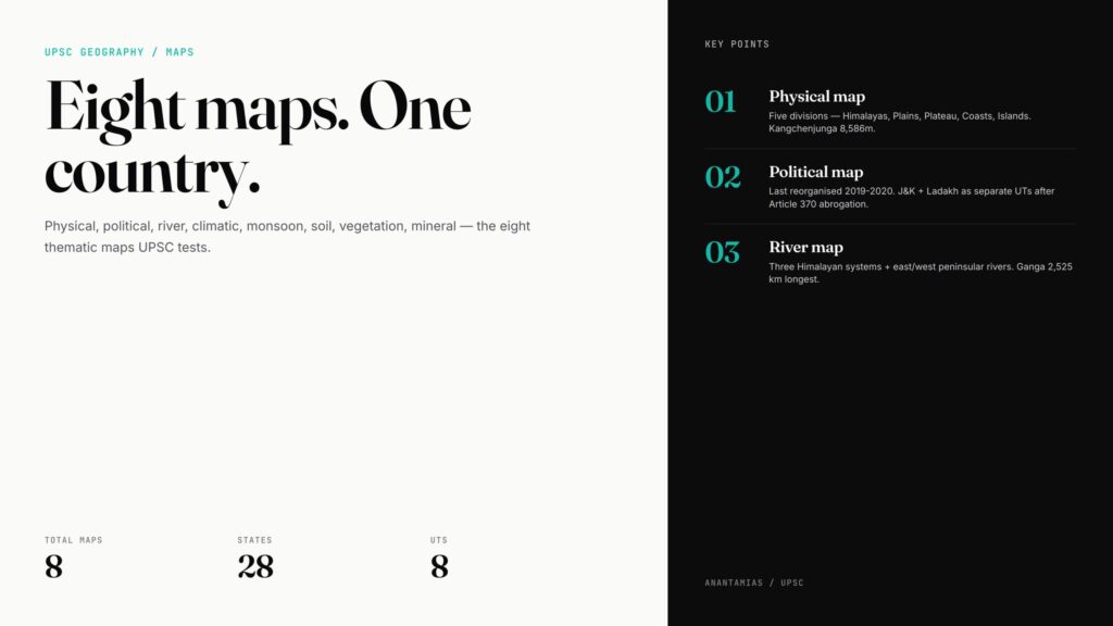
Indian geography maps are thematic visual representations of India’s territorial, physical, and economic features — covering 3,287,263 sq km, 28 states, 8 Union Territories, 7,516.6 km of coastline, and over 1.42 billion people (2024). The eight most-used UPSC maps are: physical, political, river/drainage, climatic, monsoon, soil, vegetation, and mineral.
Three quick facts:
- Total area — 3,287,263 sq km — 7th largest country (2026).
- Latitudinal extent — 8°4’N to 37°6’N — Tropic of Cancer (23.5°N) bisects.
- Longitudinal extent — 68°7’E to 97°25’E — Standard Meridian 82°30’E (Mirzapur, UP).
1. Physical map of India (Bharat ka Bhautik Manchitra)
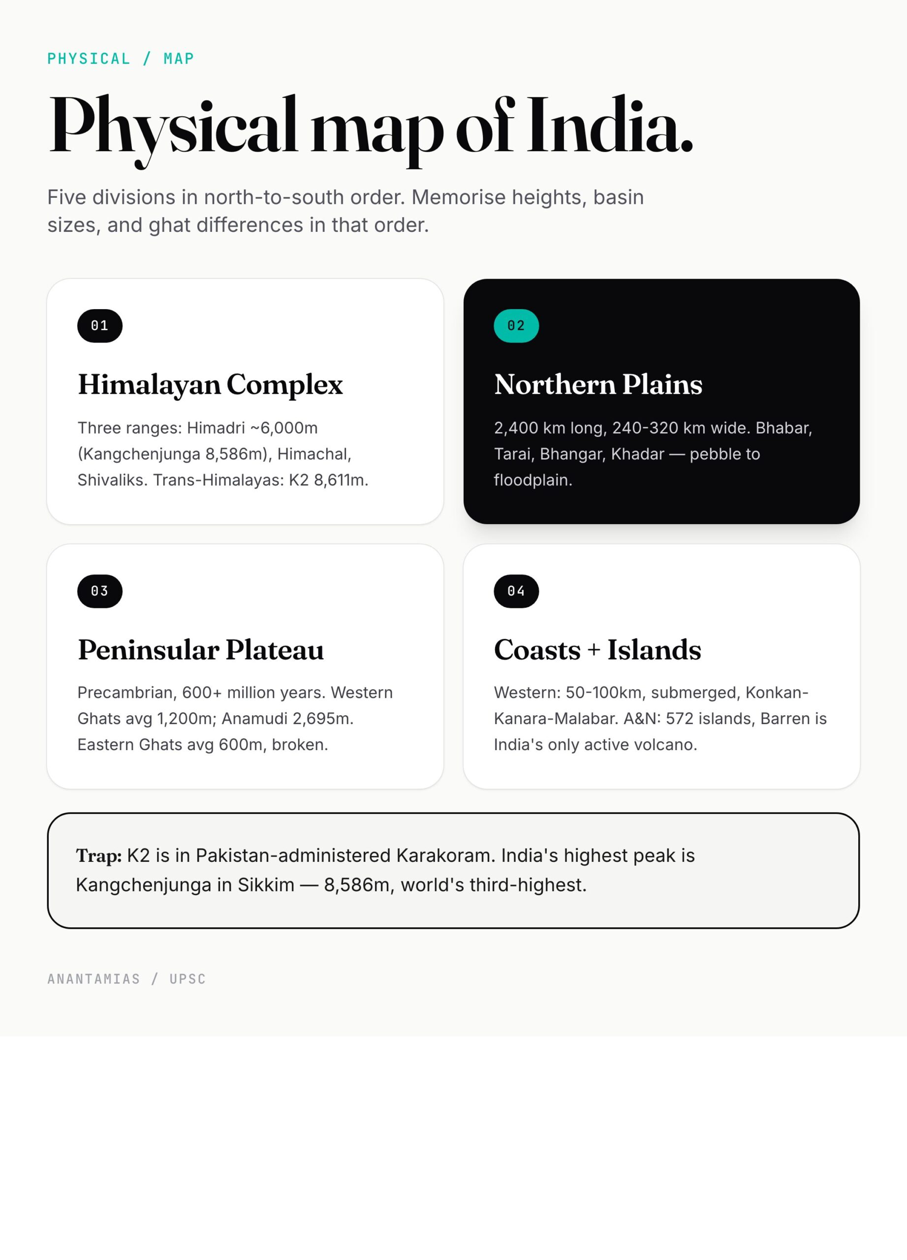
The physical map shows relief — mountains, plateaus, plains, coasts, islands. India splits into five physiographic divisions:
- Himalayan Mountain Complex — north. Three ranges: Greater (Himadri), Lesser (Himachal), Outer (Shivaliks). Highest peak — Kangchenjunga, 8,586 m, Sikkim. See Himalaya mountain.
- Northern Plains — alluvial trough between Himalayas and Peninsular Plateau, 2,400 km long, 240–320 km wide.
- Peninsular Plateau — Precambrian, 600+ million years old. Western Ghats (avg 1,200 m, Anamudi 2,695 m), Eastern Ghats (avg 600 m, broken). See peninsular plateau.
- Coastal Plains — Western (50–100 km, submerged) and Eastern (100–200 km, emergent with major deltas).
- Islands — Andaman & Nicobar (572 islands, Bay of Bengal), Lakshadweep (36 atolls, Arabian Sea). Active volcano — Barren Island.
What UPSC asks from the physical map: peak heights, range names, pass locations, ghat differences, island origins. Memorise locations, not just names.
2. Political map of India (Rajneetik Manchitra)
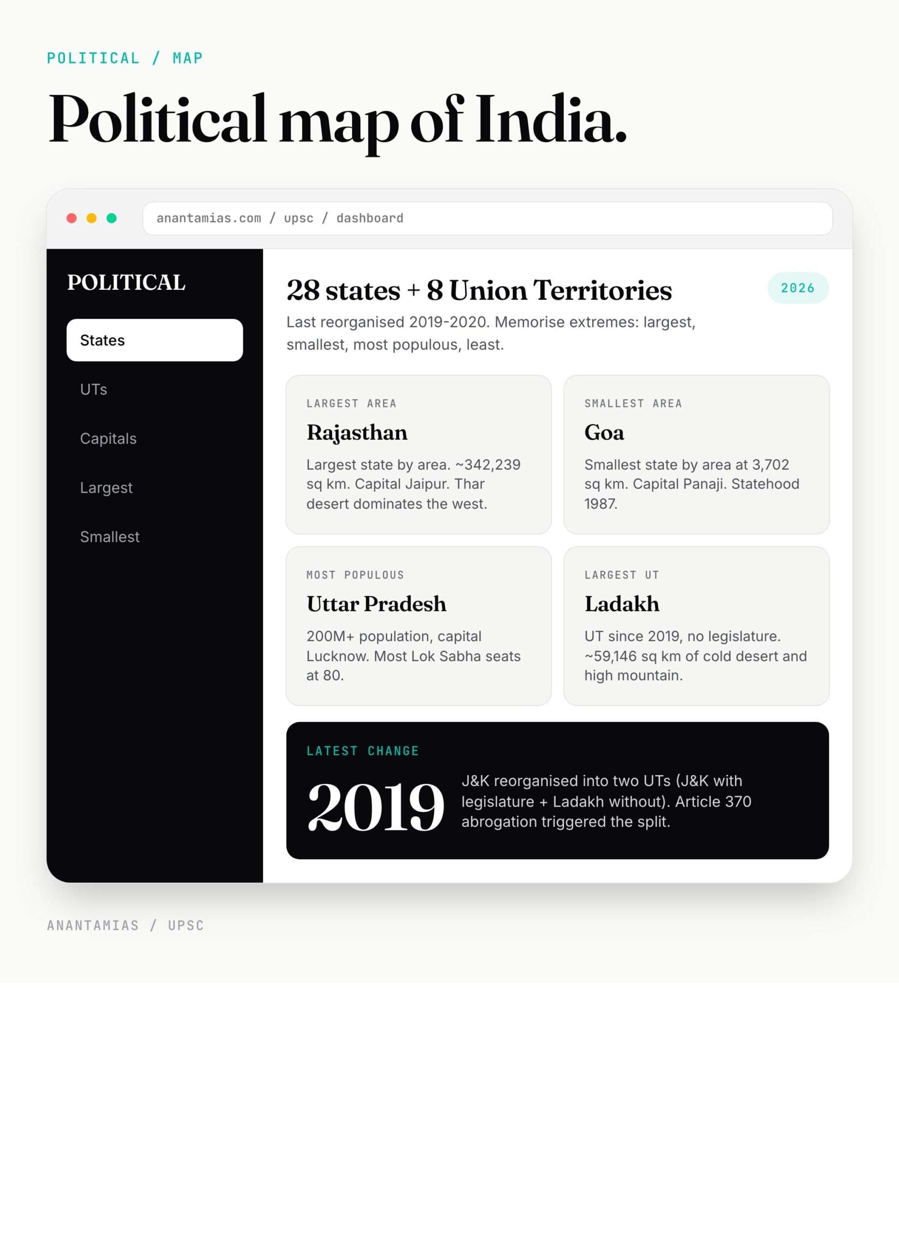
The political map carries state and UT boundaries, capitals, major cities. As of 2026:
- 28 states — Andhra Pradesh, Arunachal Pradesh, Assam, Bihar, Chhattisgarh, Goa, Gujarat, Haryana, Himachal Pradesh, Jharkhand, Karnataka, Kerala, Madhya Pradesh, Maharashtra, Manipur, Meghalaya, Mizoram, Nagaland, Odisha, Punjab, Rajasthan, Sikkim, Tamil Nadu, Telangana, Tripura, Uttar Pradesh, Uttarakhand, West Bengal.
- 8 Union Territories — Delhi, Puducherry, Jammu and Kashmir, Ladakh, Chandigarh, Dadra and Nagar Haveli & Daman and Diu, Lakshadweep, Andaman & Nicobar Islands.
Key 2019 changes — Jammu & Kashmir reorganised into two UTs (J&K with legislature, Ladakh without). 2020 — Dadra & Nagar Haveli merged with Daman & Diu. The full breakdown lives in our political map of India article.
For Prelims, lock down: largest state by area (Rajasthan), smallest (Goa), largest UT (Ladakh), smallest UT (Lakshadweep), most populous state (UP), least populous (Sikkim).
3. River map of India (Apvah Tantra Manchitra)
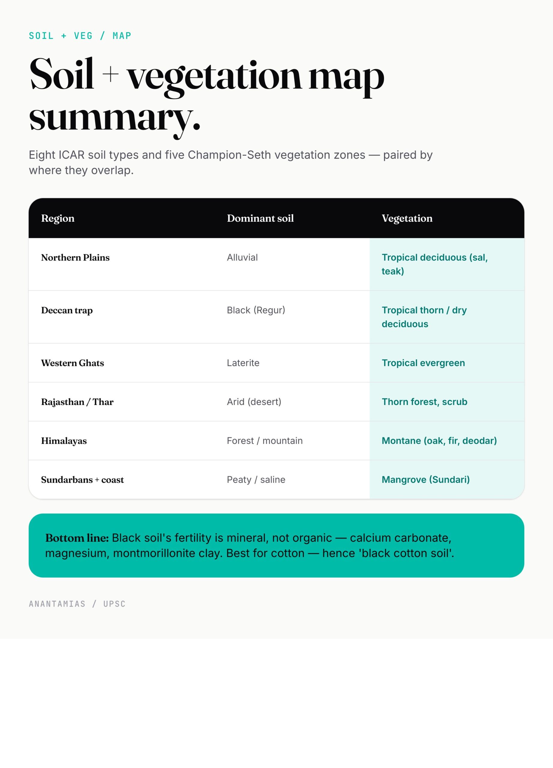
India’s drainage map shows two systems with very different signatures.
Himalayan rivers (perennial, snow + rain fed):
- Indus system — Indus, Jhelum, Chenab, Ravi, Beas, Sutlej.
- Ganga system — Ganga (2,525 km, longest in India), Yamuna, Ghaghara, Gandak, Kosi, Son. See Ganga river system.
- Brahmaputra system — Brahmaputra, Subansiri, Manas, Tista. See Brahmaputra river system.
Peninsular rivers (seasonal, rain-fed):
- East-flowing — Mahanadi, Godavari (1,465 km, longest peninsular), Krishna, Cauvery — form deltas in Bay of Bengal.
- West-flowing — Narmada (1,312 km), Tapi — form estuaries in Arabian Sea.
The full mapping lives in river systems of India. Single-river deep dives: Godavari river, Krishna river.
UPSC’s favourite map question: “Which of the following rivers does NOT originate in the Western Ghats?” The trick is always Tungabhadra, Krishna, or Cauvery confused with Godavari (which originates in the Western Ghats at Trimbakeshwar).
4. Climatic map of India (Jalvayu Manchitra)
The climatic map maps temperature, rainfall, and pressure patterns. Köppen classification recognises six zones in India:
- Aw — Tropical wet and dry (savanna) — most peninsular India.
- Am — Tropical monsoon — Kerala, coastal Karnataka, Goa, NE.
- As — Tropical wet (dry summer) — Coromandel coast.
- BWh / BSh — Hot desert and semi-arid — Rajasthan, parts of Gujarat, Punjab, Haryana.
- Cwa / Cwb — Humid subtropical — Indo-Gangetic plain.
- E — Mountain / Tundra — high Himalayas, Ladakh.
Cherrapunji and Mawsynram (Meghalaya) get over 11,000 mm annual rainfall — wettest places on Earth. Thar Desert gets under 200 mm. Same country.
See Köppen climate classification of India for the full zone-by-zone breakdown and seasons in India for the IMD four-season model.
5. Monsoon map of India (Mansoon Manchitra)
The monsoon map is climate’s seasonal cousin — showing wind direction, rainfall onset dates, and withdrawal lines.
Key features:
- Southwest monsoon — June 1 onset (Kerala) → July 15 covers all of India. Withdraws by mid-October. Brings 75% of annual rainfall.
- Two branches — Arabian Sea branch (hits Western Ghats, dumps rain on windward side, creates rain shadow east) and Bay of Bengal branch (curves into Ganga plain, climbs Himalayas, hits Cherrapunji).
- Northeast monsoon — October–December. Waters Tamil Nadu, coastal Andhra, parts of Karnataka.
The mechanism, factors, and impact get the full treatment in our monsoon in India article.
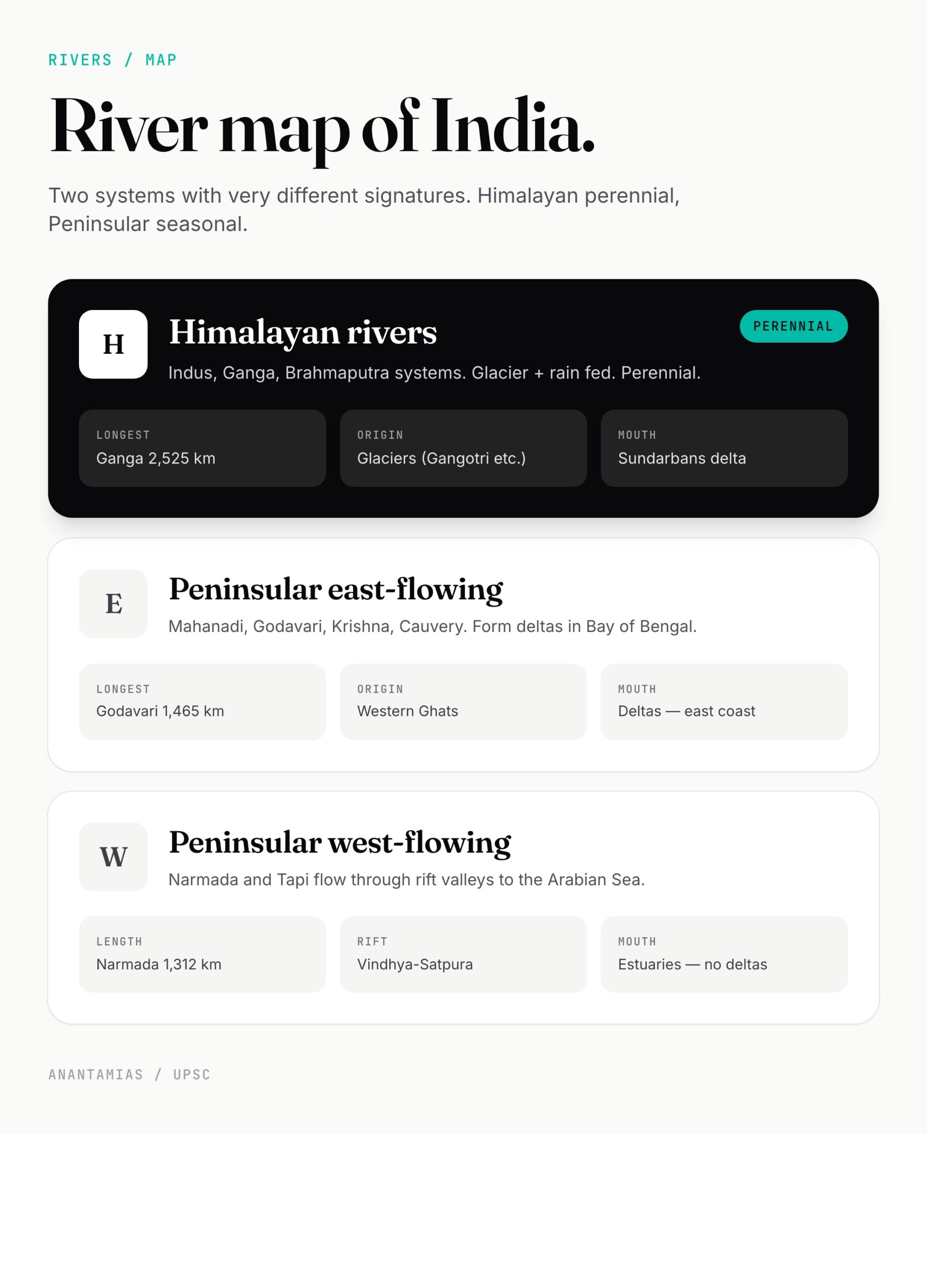
6. Soil map of India (Mitti ka Manchitra)
ICAR’s eight major soil types and their distribution:
| Soil | Where (mapped) | Main Crops |
|---|---|---|
| Alluvial | Northern Plains, river deltas, coastal strips | Rice, wheat, sugarcane |
| Black (Regur) | Deccan trap — Maharashtra, MP, Gujarat, north Karnataka | Cotton |
| Red and Yellow | Eastern Deccan, Chota Nagpur, Karnataka, parts of MP | Millets, pulses |
| Laterite | Western Ghats, NE India, Kerala, Goa, parts of Odisha | Tea, coffee, cashew, rubber |
| Arid (Desert) | Rajasthan, S. Punjab, Haryana, Kutch | Bajra, barley |
| Saline / Alkaline | Coastal areas, Rann of Kutch, parts of UP | Limited |
| Peaty / Marshy | Kerala backwaters, Sundarbans | Rice |
| Forest / Mountain | Himalayas, NE | Tea, fruits, spices |
The full deep-dive — soil types of India.
7. Vegetation map of India (Vanaspati Manchitra)
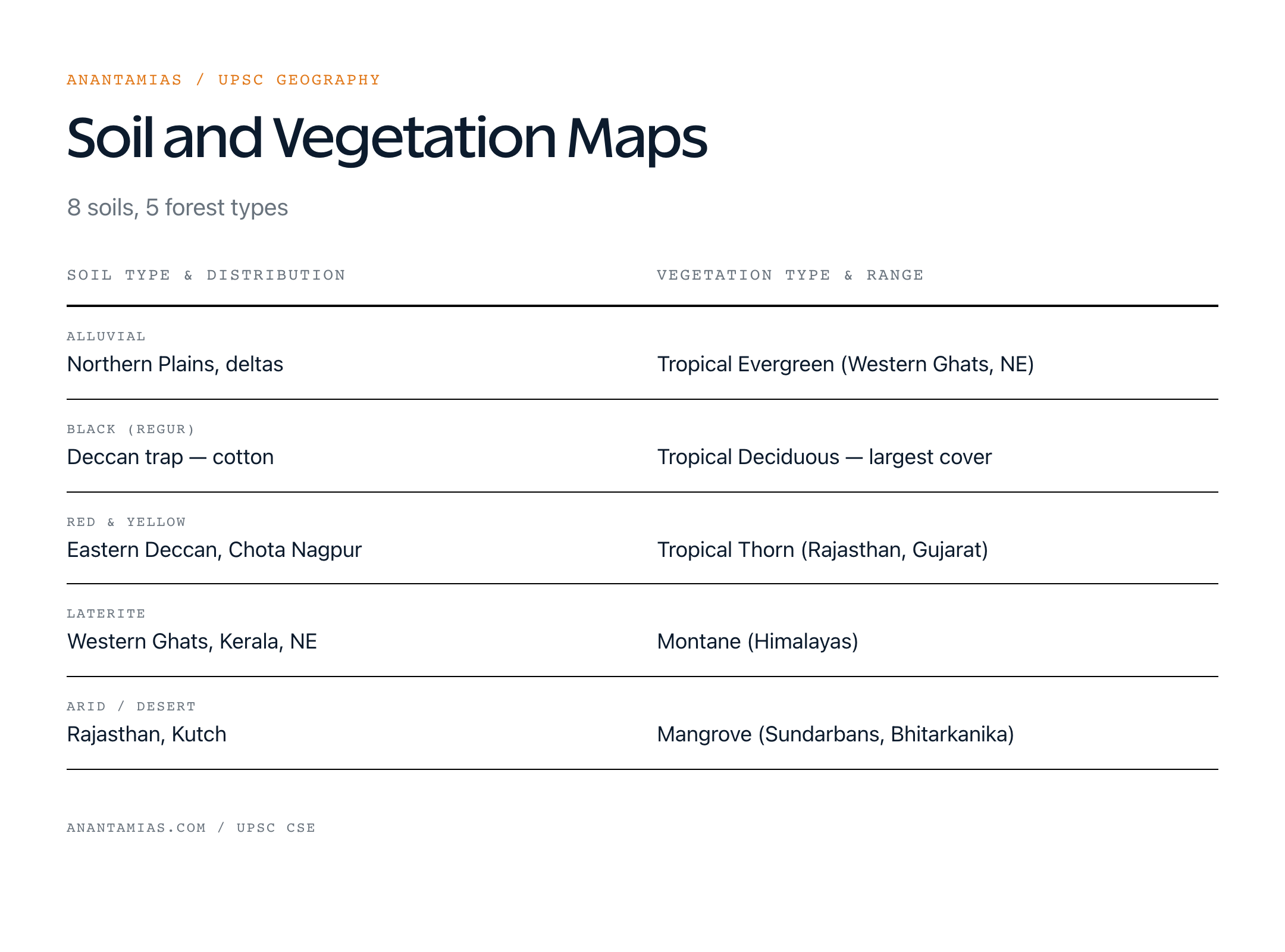
Five forest types per Champion-Seth classification:
- Tropical Evergreen — Western Ghats, Andaman, NE India. Rainfall >200 cm.
- Tropical Deciduous (Monsoon) — largest forest type. Sub-divided into Moist Deciduous (sal, teak) and Dry Deciduous.
- Tropical Thorn — Rajasthan, Gujarat, parts of MP. Rainfall <70 cm.
- Montane — Himalayas. Wet temperate, dry temperate, alpine.
- Mangrove — Sundarbans (largest), Bhitarkanika, Pichavaram.
Forest cover (India State of Forest Report 2023) — 21.71% of geographical area. Mangrove cover — 4,991.68 sq km. Read natural vegetation of India for the full taxonomy.
8. Mineral and economic maps
Indian mineral wealth concentrates in the Peninsular Plateau:
- Coal — Damodar Valley (Jharkhand, West Bengal), Mahanadi Valley (Odisha, Chhattisgarh), Godavari Valley.
- Iron ore — Singhbhum (Jharkhand), Bailadila (Chhattisgarh), Kemmangundi (Karnataka).
- Bauxite — Odisha (largest), Jharkhand, Maharashtra.
- Manganese — Odisha, MP, Maharashtra.
- Mica — Jharkhand, Andhra, Rajasthan.
- Gold — Kolar (Karnataka, now closed), Hutti (Karnataka, active).
- Petroleum — offshore Mumbai High, Gujarat (Ankleshwar), Assam (Digboi — India’s oldest oilfield).
UPSC repeatedly maps mineral belts. Memorise: Damodar = coal, Singhbhum = iron, Kolar = gold, Mumbai High = oil.
9. Population and political-economic maps
Population density map (Census 2011, 2021 paused) — Bihar (1,106/sq km), West Bengal, UP top the chart. Arunachal Pradesh (17/sq km) lowest. Density follows alluvial plains and coastal strips.
Linguistic map — 22 scheduled languages (Schedule VIII), Hindi belt north, Dravidian belt south, Bengali east, Marathi-Gujarati west.
Religion map — Hindu majority everywhere except J&K, Lakshadweep, Punjab (Sikh majority), Mizoram-Nagaland-Meghalaya (Christian majority).
Why these maps matter for UPSC
Prelims — UPSC has steadily increased map-based questions. 2024 had 5+ direct map MCQs. 2023, 2022 — same trend. Locate-the-feature questions are practically guaranteed.
Mains GS-I — geography questions almost always benefit from a sketched map answer. “Discuss the impact of climate change on the Indian monsoon” — answer with a labelled monsoon-map sketch and you’ll outscore textual answers.
Interview — board members ask about your home state’s geography. Be ready with district-level maps if you’re from a coastal or border state.
Honestly… map memorisation looks tedious until you start scoring 6 extra marks per Prelims paper. After that it just looks like the highest-ROI study activity in the syllabus.
Common misconceptions
- “Western Ghats run through 6 states” — Six is a popular wrong answer. Correct: 6 states — Gujarat, Maharashtra, Goa, Karnataka, Kerala, Tamil Nadu — but the Ghats officially run through Gujarat too only at the northern tip. UNESCO World Heritage Western Ghats serial property covers 39 sites across the southern five.
- “All Himalayan rivers originate in the Himalayas” — Wrong. The Brahmaputra and Indus both originate in Tibet, north of the Himalayas, and cut through them.
- “Largest UT is Andaman & Nicobar” — No. Ladakh has been the largest UT by area since 2019 reorganisation.
- “Gold is mined at Kolar” — Past tense. Kolar Gold Fields shut in 2001. India’s only operational gold mine is Hutti, Karnataka.
How to use Indian geography maps for revision
Source priority:

Oxford Student Atlas for India — 7th Edition
- 160 pages, Oxford University Press, the current edition
- India-focused thematic maps: physical, political, rivers, climate, soils, vegetation, plus world maps
- Made for UPSC and state PSC map work; slim enough to stay open beside the textbook
- NCERT Class 11 — *India: Physical Environment (every map labelled).
- Orient Blackswan or Oxford School Atlas of India (the standard).
- PMF IAS Geography Maps (free, well-categorised online).
- Survey of India outline maps (free PDF downloads).
- Mahesh Barnwal — *Indian Geography (state-wise maps embedded).
Revision drill — print blank India outline maps. Fill in: rivers (one map), peaks and ranges (another), states (third), soils (fourth), monsoon arrows (fifth). Repeat weekly. After 4 weeks, map questions feel automatic.
Frequently Asked Questions
What are the most important maps for UPSC geography?
Eight — physical, political, river, climatic, monsoon, soil, vegetation, mineral. Prelims tests all eight regularly.
How many states and UTs does India have in 2026?
28 states and 8 Union Territories — same as 2020 onwards, after J&K reorganisation (2019) and Dadra-Daman-Diu merger (2020).
Which is the longest river in India shown on the river map?
Ganga — 2,525 km. Longest peninsular river — Godavari — 1,465 km.
What does a climatic map of India show?
Köppen climate zones (six in India), temperature isotherms, rainfall isohyets, monsoon onset and withdrawal lines.
How many soil types appear on the Indian soil map?
Eight major types per ICAR — alluvial, black (regur), red and yellow, laterite, arid, saline-alkaline, peaty, and forest soils.
Where can I download Indian geography maps PDF for UPSC?
NCERT textbooks (free, official), Survey of India website, Drishti IAS PDF library, and PMF IAS — all carry UPSC-relevant outline and thematic maps.
Which is India’s highest peak on the physical map?
Kangchenjunga — 8,586 m — Sikkim — third-highest in the world.
How many Ramsar sites does India have in 2026?
99 Ramsar sites (April 2026), covering 13.6 lakh hectares. Tamil Nadu has the highest count (20).
Tell Google you want more of this.
Add Anantam IAS as a preferred sourceOne tap, and this site shows up more often in your own Top Stories, AI Overviews and AI Mode. Remove it any time.