Godavari River Map: Origin, Tributaries & UPSC Notes
Complete guide to the Godavari River — origin at Trimbakeshwar, tributaries, basin states, dams, and UPSC Prelims and Mains relevance with map-based clarity.
Introduction
The Godavari River, often called Dakshin Ganga (the Ganga of the South), is the second longest river in India and the longest river of peninsular India. Rising in the Western Ghats and flowing east across the Deccan Plateau to the Bay of Bengal, the Godavari drains nearly 10% of India's geographical area and sustains agriculture, industry, and pilgrimage traditions across seven states. A clear mental map of the Godavari is critical for UPSC Prelims geography questions.
This guide covers the river's origin, course, tributaries, basin states, major dams, economic importance, and UPSC relevance — with detailed map-reading cues.
Origin and Course
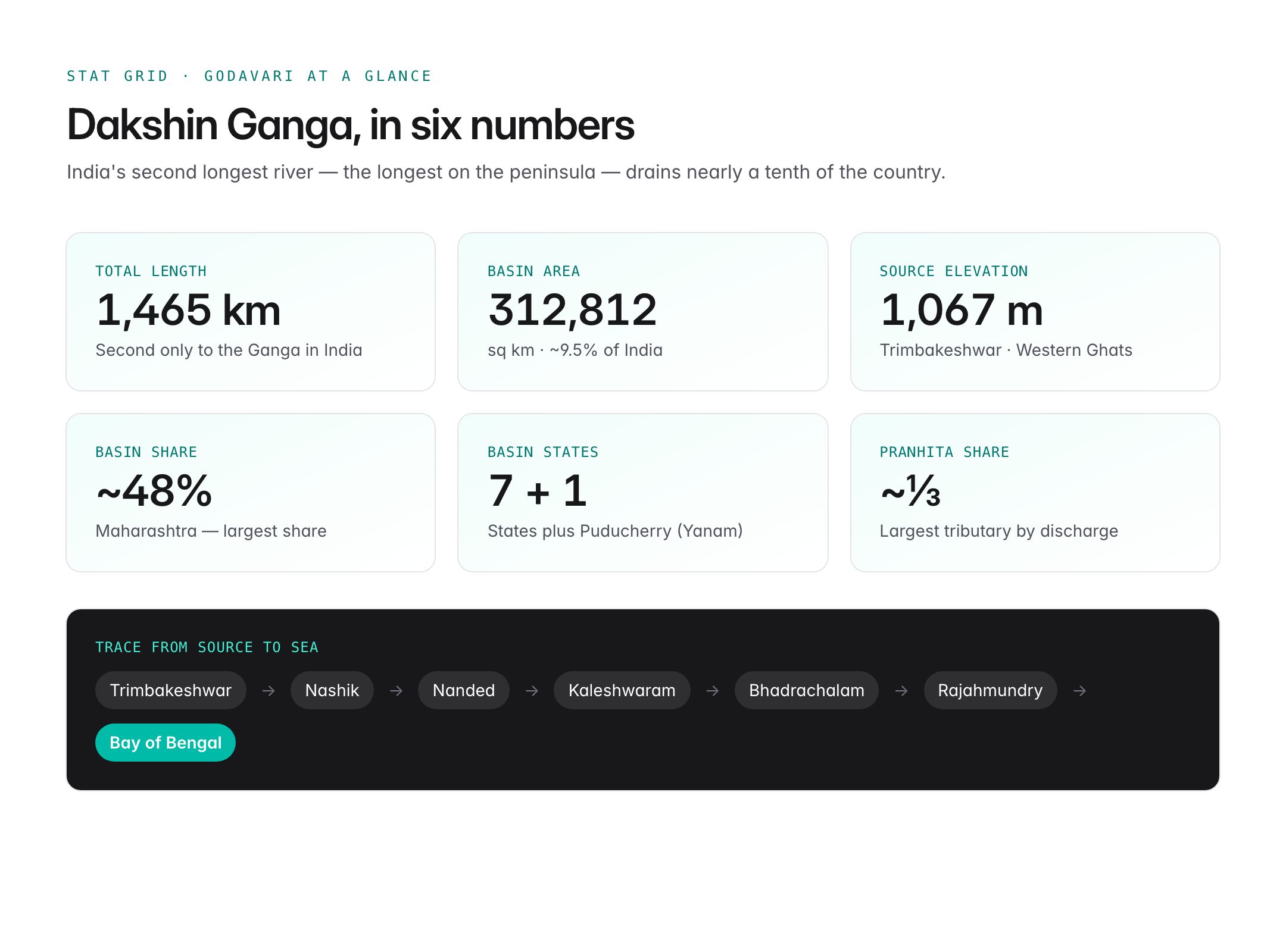
- Source: Trimbakeshwar near Nashik in Maharashtra, at an elevation of about 1,067 m in the Western Ghats.
- Total length: Approximately 1,465 km, second only to the Ganga within India.
- Mouth: Drains into the Bay of Bengal near Antarvedi in Andhra Pradesh, forming a large delta shared with the Krishna.
- Basin area: About 312,812 sq km — roughly 9.5% of India's total geographical area.
Course Overview
The Godavari flows generally west to east, passing through:
- Maharashtra (upper reaches): Nashik, Ahmednagar, Nanded.
- Telangana: along the northern border; joined by the Pranhita and Manjira.
- Chhattisgarh and Madhya Pradesh: minor basin portions.
- Andhra Pradesh: forms the large delta around Rajahmundry and Kakinada.
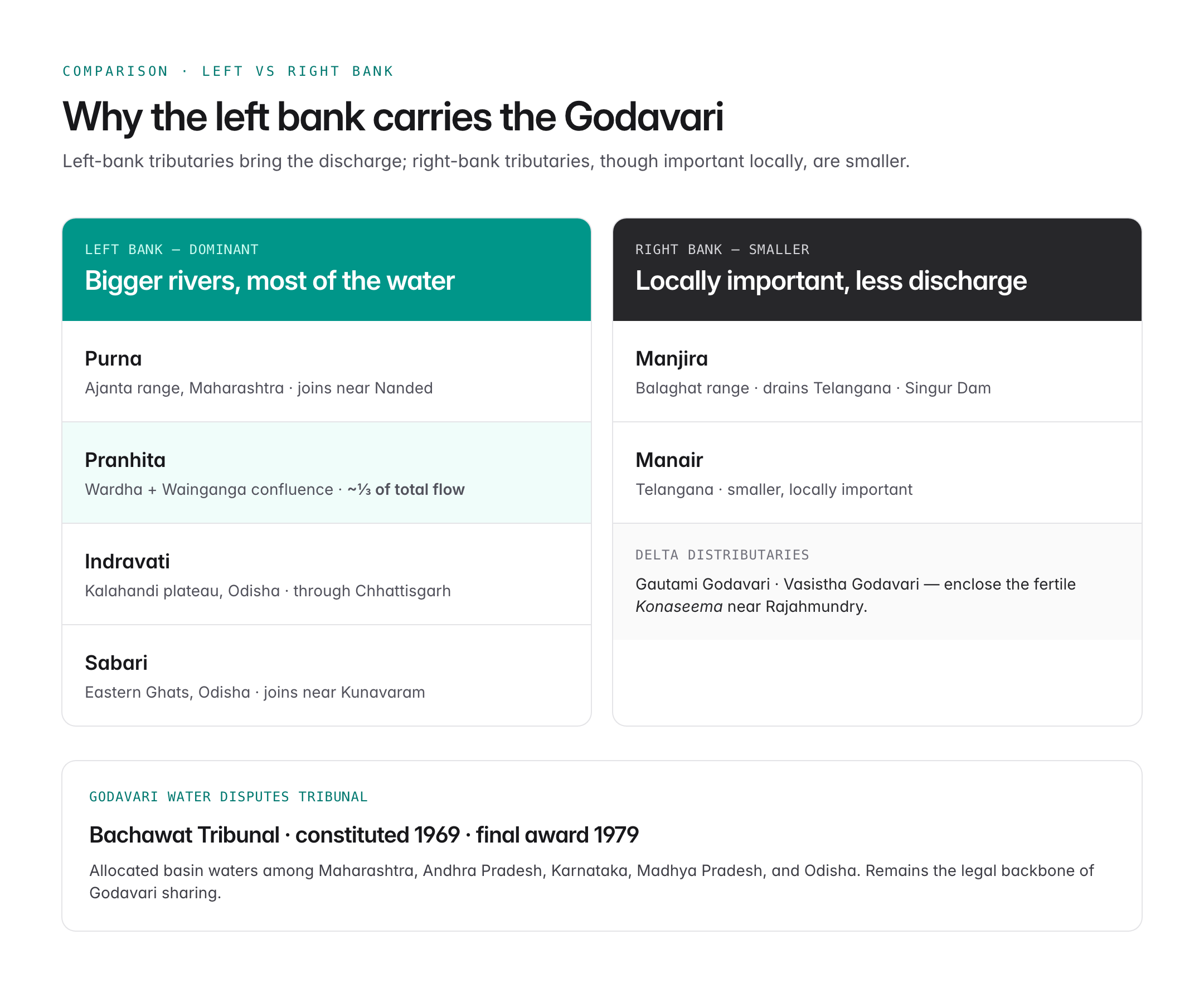
Near Rajahmundry, the Godavari bifurcates into two major distributaries — Gautami Godavari and Vasistha Godavari — enclosing the fertile Konaseema region.
Major Tributaries
Left-Bank Tributaries (larger, bring more water)
| Tributary | Origin | Notes |
|---|---|---|
| Purna | Ajanta range, Maharashtra | Joins near Nanded |
| Pranhita | Confluence of Wardha and Wainganga | Largest tributary by discharge |
| Indravati | Kalahandi plateau, Odisha | Flows through Chhattisgarh |
| Sabari | Eastern Ghats, Odisha | Joins near Kunavaram |
The Pranhita alone contributes about one-third of the Godavari's total flow, making it hydrologically the most important tributary.
Right-Bank Tributaries
| Tributary | Origin | Notes |
|---|---|---|
| Manjira | Balaghat range, Maharashtra | Drains Telangana; has Singur Dam |
| Manair | Telangana | Smaller but locally important |
Basin States
The Godavari basin is shared by seven states and one Union Territory:
- Maharashtra (about 48% of the basin) — largest share.
- Telangana
- Andhra Pradesh
- Chhattisgarh
- Madhya Pradesh
- Odisha
- Karnataka
- Puducherry (through Yanam enclave in the delta)
Major Dams and Projects
| Project | River | State |
|---|---|---|
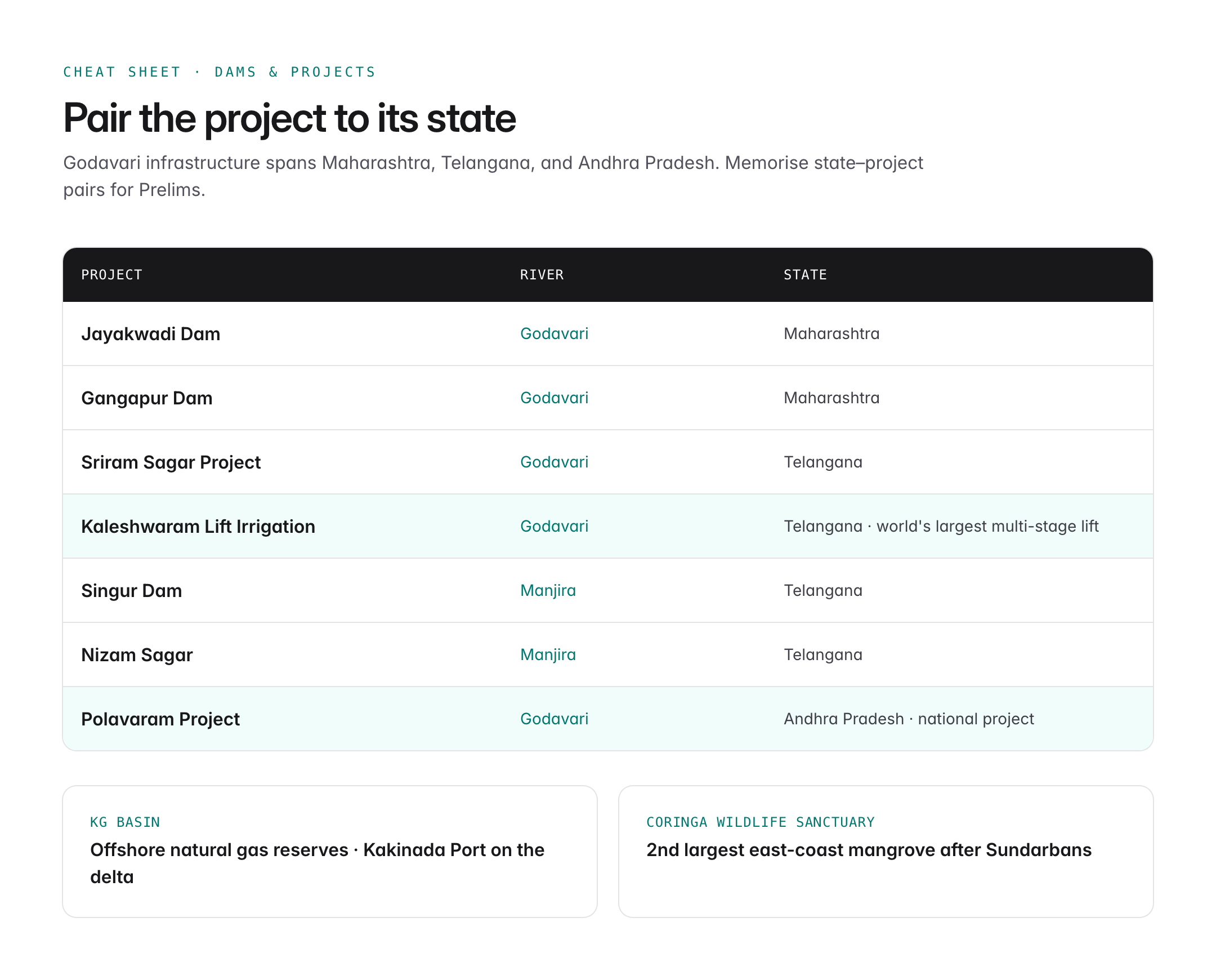
| Jayakwadi Dam | Godavari | Maharashtra |
| Gangapur Dam | Godavari | Maharashtra |
| Polavaram Project | Godavari | Andhra Pradesh |
| Sriram Sagar Project | Godavari | Telangana |
| Kaleshwaram Lift Irrigation | Godavari | Telangana |
| Singur Dam | Manjira | Telangana |
| Nizam Sagar | Manjira | Telangana |
The Kaleshwaram Lift Irrigation Project is among the largest multi-stage lift irrigation schemes in the world, designed to lift Godavari water up to drier northern Telangana.
The Polavaram Project in Andhra Pradesh is a multipurpose irrigation, hydropower, and drinking water project classified as a national project under the AP Reorganisation Act, 2014.
Godavari Delta
- The delta is one of the most fertile agricultural zones in India.
- Staple crops include rice, sugarcane, tobacco, banana, and coconut.
- The delta supports the Coringa Wildlife Sanctuary, home to the second largest mangrove forest on India's east coast after the Sundarbans.
- Kakinada Port and the KG Basin (Krishna-Godavari Basin) offshore hold major natural gas reserves.
Cultural and Religious Significance
- The Godavari is called Dakshin Ganga and features prominently in the Ramayana — Rama, Sita, and Lakshmana spent part of their exile at Panchavati (near Nashik) on the Godavari.
- Trimbakeshwar at the source is one of the twelve Jyotirlingas.
- The Pushkaram festival is held every 12 years when Jupiter enters Leo, drawing millions of pilgrims to Rajahmundry and Basar.
- Bhadrachalam on the Godavari is a major Rama temple site.
Godavari Water Disputes Tribunal
The Godavari Water Disputes Tribunal (GWDT), chaired by Justice Bachawat, was constituted in 1969 under the Inter-State Water Disputes Act, 1956. It delivered its final award in 1979, allocating basin waters among Maharashtra, Andhra Pradesh, Karnataka, Madhya Pradesh, and Odisha. The award remains the legal backbone of Godavari water-sharing, though its implementation has periodic disputes among successor states of AP and Telangana.
Ecological and Environmental Issues
- Pollution from urban sewage at Nashik, Nanded, and Rajahmundry — the Namami Gange-style programme extended to Godavari has seen limited progress.
- Sand mining in the lower reaches threatens delta stability.
- Invasive weeds like water hyacinth in stagnant stretches.
- Climate change-driven variability in monsoon rainfall affecting runoff.
Map-Reading Tips
On a physical map of India, locate the Godavari by tracing:

Oxford Student Atlas for India — 7th Edition
- 160 pages, Oxford University Press, the current edition
- India-focused thematic maps: physical, political, rivers, climate, soils, vegetation, plus world maps
- Made for UPSC and state PSC map work; slim enough to stay open beside the textbook
- Trimbakeshwar near Nashik in the Sahyadri range.
- Flow through the Ajanta–Balaghat uplands.
- Confluence with Pranhita at Kaleshwaram, Telangana.
- Confluence with Indravati near Bhadrakali.
- Delta bifurcation at Dhavaleswaram barrage, Rajahmundry.
- Mouth near Antarvedi in the Bay of Bengal.
UPSC Relevance
Prelims angle: Remember the source (Trimbakeshwar, Nashik), length (~1,465 km), largest tributary by discharge (Pranhita), basin states (seven), and major dams (Jayakwadi, Sriram Sagar, Polavaram, Kaleshwaram). Know that the Godavari is India's second longest river and the longest peninsular river. MCQs often pair tributaries with origin (Indravati–Kalahandi, Pranhita–Wardha/Wainganga).
Mains GS I angle: Use the Godavari in answers on peninsular drainage, interlinking of rivers (Godavari-Krishna-Cauvery), federal water disputes, and climate change impact on peninsular rainfall. Link to the Polavaram and Kaleshwaram projects for questions on infrastructure and agriculture.
PYQ angle:
- Prelims 2014: MCQ on Krishna-Godavari Basin natural gas.
- "What is water stress? How and why does it differ regionally in India?" — peninsular context fits.
- Prelims 2023: MCQ pairing rivers with tributaries.
Map the Godavari once carefully and it will reward you across Prelims, Mains, and Interview.