Indian Ocean: Geography, Significance & UPSC Notes
Complete guide to the Indian Ocean — geography, strategic significance, bordering countries, trade routes, and key facts for UPSC preparation.
Indian Ocean: Geography, Significance & UPSC Notes
The Indian Ocean is the third-largest ocean in the world, covering approximately 70.56 million square kilometres. It stretches from East Africa to Australia and from South Asia to Antarctica. For UPSC aspirants, understanding its geography, strategic chokepoints, and geopolitical importance is essential — questions on maritime geography, trade routes, and India’s maritime policy appear regularly across Prelims and Mains.
Physical Geography of the Indian Ocean
The Indian Ocean is bounded by Asia to the north, Africa to the west, Australia to the east, and Antarctica to the south. Unlike the Atlantic and Pacific, it doesn’t extend into the Arctic region — making it the only major ocean confined largely to the Southern Hemisphere.
Key Physical Features
The ocean floor contains several significant geological formations:
- Mid-Indian Ocean Ridge — runs roughly north-south, dividing the ocean floor into eastern and western sections
- Chagos-Laccadive Ridge — extends from the Laccadive Islands to the Chagos Archipelago
- Ninety East Ridge — one of the longest and straightest features on Earth, running along 90°E longitude
- Carlsberg Ridge — connects to the Central Indian Ridge system
The average depth is about 3,741 metres. The deepest point is the Sunda Trench (also called Java Trench) near Indonesia, reaching 7,450 metres.
Major Seas and Gulfs
| Water Body | Location | Significance |
|---|---|---|
| Arabian Sea | West of India | Major trade route; connects to Red Sea via Gulf of Aden |
| Bay of Bengal | East of India | Cyclone-prone; receives Ganga-Brahmaputra drainage |
| Red Sea | Between Africa and Arabian Peninsula | Links to Mediterranean via Suez Canal |
| Persian Gulf | Between Iran and Arabian Peninsula | World’s largest oil transit corridor |
| Mozambique Channel | Between Mozambique and Madagascar | Warm Agulhas Current flows through |
| Andaman Sea | Between Andaman Islands and Southeast Asia | Strategic for Malacca Strait access |
Indian Ocean Rim Countries
The Indian Ocean Rim Association (IORA) has 23 member states and 11 dialogue partners. The bordering countries span three continents — Africa, Asia, and Oceania.
Major Bordering Nations
Asian coast: India, Pakistan, Bangladesh, Sri Lanka, Myanmar, Thailand, Indonesia, Malaysia, Oman, Yemen, Iran, and the UAE.
African coast: South Africa, Mozambique, Tanzania, Kenya, Somalia, Djibouti, Eritrea, Egypt (via Red Sea), and Madagascar.
Oceanian coast: Australia.
Island nations: Maldives, Seychelles, Mauritius, Comoros, and Madagascar.
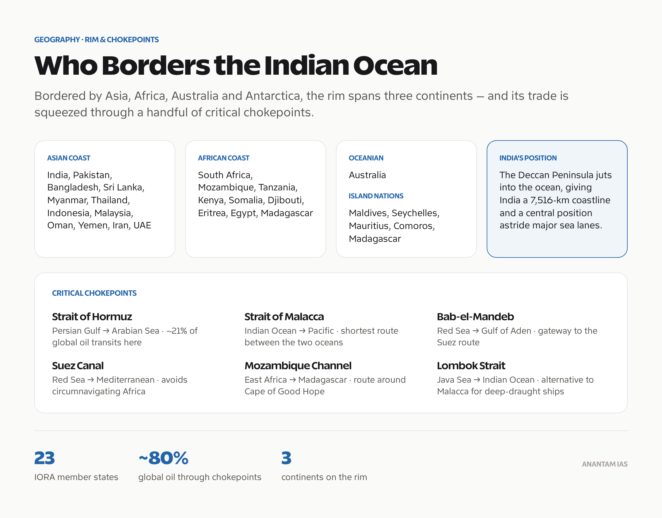
India occupies a central position in the Indian Ocean. The Deccan Peninsula juts out into the ocean, giving India a 7,516-km coastline and strategic proximity to major sea lanes.
Strategic Significance of the Indian Ocean
The Indian Ocean isn’t just a body of water — it’s a geopolitical chessboard. Roughly 80% of global oil trade passes through its chokepoints. Control over these routes translates directly into economic and military leverage.
Critical Chokepoints
| Chokepoint | Connects | Strategic Value |
|---|---|---|
| Strait of Hormuz | Persian Gulf to Arabian Sea | ~21% of global oil supply transits here |
| Strait of Malacca | Indian Ocean to Pacific Ocean | Shortest sea route between Indian and Pacific Oceans |
| Bab-el-Mandeb | Red Sea to Gulf of Aden | Gateway to Suez Canal route |
| Mozambique Channel | East Africa to Madagascar | Alternative route around Cape of Good Hope |
| Suez Canal | Red Sea to Mediterranean | Eliminates need to circumnavigate Africa |
| Lombok Strait | Java Sea to Indian Ocean | Alternative to Malacca for deep-draught vessels |
Trade Route Dominance
The Indian Ocean carries about half of the world’s container shipments and one-third of global bulk cargo. The Sea Lines of Communication (SLOCs) connecting the Persian Gulf to East Asia pass directly through India’s maritime neighbourhood.
Key trade flows include:
- Oil and LNG from the Persian Gulf to East Asia
- Manufactured goods from East Asia to Europe and Africa
- Raw materials from Africa and Australia to Asian markets
India’s Maritime Strategy in the Indian Ocean
India’s strategic doctrine treats the Indian Ocean as its primary area of influence. The 2015 SAGAR (Security and Growth for All in the Region) vision articulates this approach.
Key Policy Frameworks
- SAGAR Initiative — launched by Prime Minister Modi in 2015 to promote cooperative maritime development
- Indian Navy’s Maritime Doctrine — emphasises sea control, sea denial, and maritime presence
- Sagarmala Programme — port-led development strategy to leverage India’s coastline
- Mission-Based Deployments — Indian Navy maintains continuous presence at major chokepoints
Naval Infrastructure
India operates major naval commands at:
- Western Naval Command — Mumbai (Arabian Sea)
- Eastern Naval Command — Visakhapatnam (Bay of Bengal)
- Southern Naval Command — Kochi (training and logistics)
- Andaman and Nicobar Command — Port Blair (tri-service; guards Malacca Strait approach)
India also has access arrangements and facilities in Oman (Duqm), Seychelles (Assumption Island), Madagascar, Mauritius (Agaléga), and Singapore.
Indian Ocean and Climate
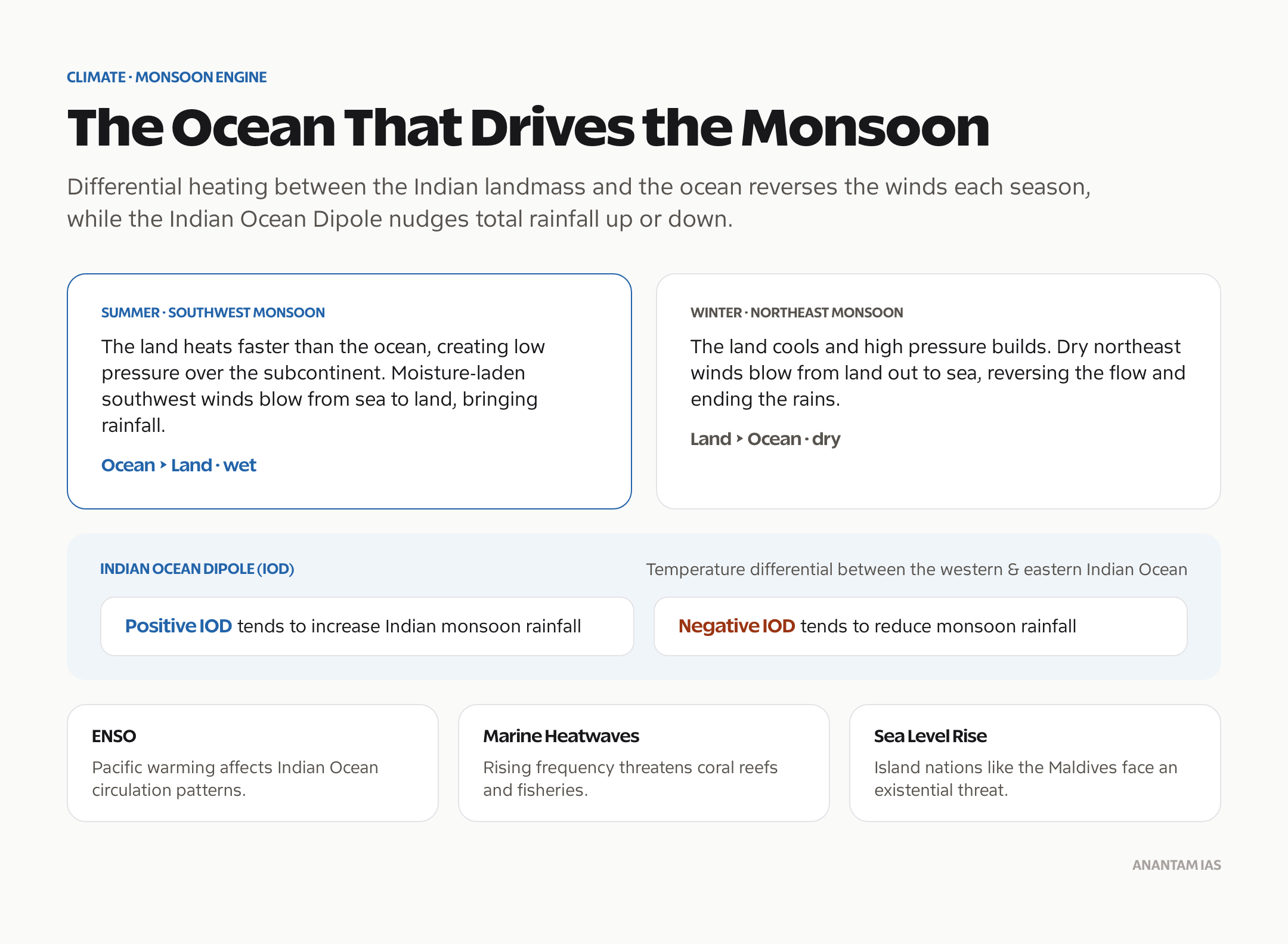
The Indian Ocean drives the monsoon system that determines India’s agricultural calendar. The Indian Ocean Dipole (IOD) — a temperature differential between the western and eastern Indian Ocean — significantly affects rainfall patterns.
Monsoon Mechanism
The differential heating between the Indian landmass and the Indian Ocean creates pressure gradients that drive monsoon winds. During summer, the ocean’s moisture-laden southwest winds bring rainfall to the subcontinent. During winter, dry northeast winds blow from land to sea.
Climate Phenomena
- Indian Ocean Dipole (IOD): Positive IOD tends to increase Indian monsoon rainfall; negative IOD reduces it
- El Nino-Southern Oscillation (ENSO): Warming in the Pacific affects Indian Ocean circulation patterns
- Marine Heatwaves: Increasing frequency threatens coral reefs and fisheries
- Sea Level Rise: Island nations like Maldives face existential threat from rising waters
El Nino & La Nina: Impact on Indian Monsoon
Marine Resources and Economy
The Indian Ocean is rich in both living and non-living resources. Fisheries, mineral deposits, and energy resources make it economically vital for all bordering states.
Key Resources
- Fisheries: Tuna, shrimp, and other species support the livelihoods of millions in coastal communities
- Polymetallic Nodules: India has been allocated a 75,000 sq km exploration area in the Central Indian Ocean Basin by the International Seabed Authority
- Hydrocarbons: Offshore oil and gas reserves in the Arabian Sea (Bombay High), Persian Gulf, and Australian continental shelf
- Rare Earth Minerals: Seabed deposits hold potential for cobalt, nickel, and manganese
Blue Economy
The blue economy concept encompasses sustainable use of ocean resources. India’s Deep Ocean Mission (launched 2021) aims to explore and harvest deep-sea resources using indigenous technology, including the Samudrayaan manned submersible programme.
Security Challenges in the Indian Ocean
The Indian Ocean faces multiple non-traditional security threats that complicate governance and stability.
Major Threats
- Piracy: Particularly off the coast of Somalia and in the Gulf of Guinea
- Illegal, Unreported, and Unregulated (IUU) Fishing: Depletes fish stocks and undermines food security
- Drug Trafficking: The “southern route” for Afghan heroin passes through the western Indian Ocean
- Maritime Terrorism: Threats to ports and shipping lanes
- China’s String of Pearls: Network of Chinese-funded ports (Gwadar, Hambantota, Djibouti) perceived as potential dual-use military assets
Multilateral Cooperation
The Indian Ocean Naval Symposium (IONS) brings together navies from 25 member states. Other frameworks include the Combined Maritime Forces (CMF), the Djibouti Code of Conduct, and bilateral exercises like MALABAR (India-US-Japan-Australia) and MILAN.
Frequently Asked Questions
Why is the Indian Ocean strategically important for UPSC?
The Indian Ocean carries roughly half the world’s container traffic and one-third of bulk cargo. Its chokepoints — Hormuz, Malacca, Bab-el-Mandeb — control global oil flows. UPSC tests this in geography, international relations, and security papers. Understanding maritime geopolitics is essential for both Prelims and GS-II/GS-III Mains answers.
Which is the deepest point in the Indian Ocean?
The Sunda Trench (Java Trench) near Indonesia holds the record at approximately 7,450 metres. It formed due to the subduction of the Indo-Australian Plate beneath the Eurasian Plate. This trench runs parallel to the Indonesian island arc and is associated with frequent seismic and volcanic activity.
What is India’s SAGAR policy?
SAGAR stands for Security and Growth for All in the Region. Launched in 2015, it articulates India’s vision for cooperative maritime development in the Indian Ocean. The policy promotes capacity building, disaster relief cooperation, and economic partnerships with island nations and littoral states across the Indian Ocean Rim.
How does the Indian Ocean Dipole affect the Indian monsoon?
The Indian Ocean Dipole is a periodic temperature oscillation between the western and eastern Indian Ocean. A positive IOD — warmer west, cooler east — generally strengthens the Indian monsoon and increases rainfall. A negative IOD has the opposite effect, often causing drought conditions in peninsular India.
What is China’s String of Pearls strategy?
The String of Pearls refers to China’s network of commercial and potentially military facilities around the Indian Ocean — including ports at Gwadar (Pakistan), Hambantota (Sri Lanka), and a naval base in Djibouti. India views this encirclement with concern and has responded with its own outreach to island nations and expanded naval presence.