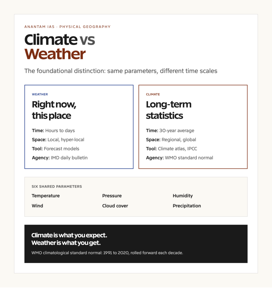
Climate vs weather is the foundational distinction in atmospheric science, and it’s the first concept every UPSC geography paper expects an aspirant to handle cleanly. Weather is what is happening outside today, this hour, this minute. Climate is the long-term statistical pattern of weather over a span of decades. A storm is weather. A monsoon system is climate. The World Meteorological Organization sets the conventional climatological reference period at thirty years, currently running from 1991 to 2020, and that is the window most national meteorological agencies use to define what counts as normal weather for any given place.
The conceptual error that costs aspirants marks is treating the two as synonyms. They share parameters, temperature, pressure, humidity, wind, rainfall, and the same physical instruments, but they operate at very different time and space scales. Weather is local, immediate, and forecast hours to days ahead. Climate is regional or global, statistical, and analyzed over decades or centuries. The instruments overlap, the science behind them is largely the same, but the questions they answer are not the same questions.
This piece works through the precise difference between climate and weather, the parameters and time scales involved, the Köppen classification that still anchors most global climate maps, India’s specific climate types under that system, the monsoon machinery, and the institutional framework of the IMD and the WMO. It’s pitched for UPSC GS Paper 1 physical geography, with side-glances at GS Paper 3 environment where climate change comes in.
Quick Facts at a Glance
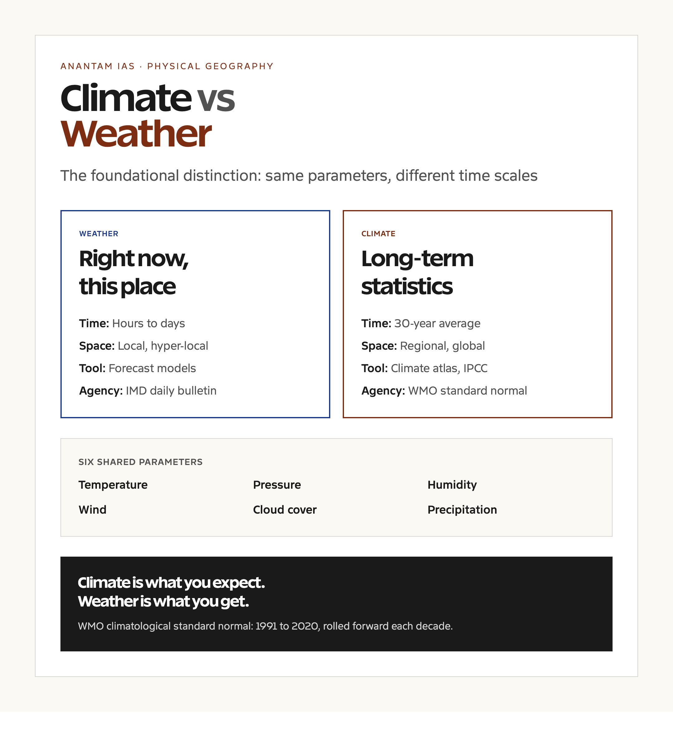
- Weather: Short-term atmospheric state at a specific location, measured in hours to days
- Climate: Long-term statistical pattern of weather, conventionally averaged over a 30-year period
- WMO climatological standard normal: 1991 to 2020 (the current reference period)
- Six core parameters: Temperature, pressure, humidity, wind speed and direction, cloud cover, precipitation
- Köppen system: Most widely used climate classification, five main groups A (tropical), B (arid), C (temperate), D (cold), E (polar)
- India’s main Köppen types: Aw, As, Am, BSh, BSk, BWh, Cwa, Cwb, Cfa
- National agency: India Meteorological Department (IMD), established 1875, headquartered in New Delhi
- Global body: World Meteorological Organization (WMO), UN specialized agency, headquartered in Geneva
- Indian climate driver: Monsoon system, with the southwest monsoon June to September and northeast monsoon October to December
Climate vs Weather: The Precise Difference
Weather is the atmospheric state at a particular place and time. It is what a person standing outside experiences and what a thermometer, barometer, hygrometer, anemometer, and rain gauge can record in real time. Weather changes hour by hour. The temperature in Delhi at noon today is weather. The thunderstorm that hit Mumbai yesterday evening is weather. The forecast for tomorrow morning is weather.
Climate is the long-run statistical description of weather for a place or region. The WMO definition uses a thirty-year averaging period, the climatological standard normal, and rolls it forward every ten years. The current standard runs from 1991 to 2020. India’s average annual rainfall figure of about 1170 millimetres for the All-India Mean Rainfall is climate. The fact that India’s southwest monsoon brings about 75 percent of the country’s annual rainfall is climate. The way the Western Ghats wring rain out of the southwest monsoon and produce one of the wettest spots on earth at Mawsynram is climate.
The space scale also differs. Weather can be hyper-local. A microburst can flatten one neighbourhood and leave the next one untouched. Climate is regional at minimum. We speak of the climate of the Indo-Gangetic plains, not the climate of Connaught Place. A useful rule of thumb is that climate is what you expect, weather is what you get. The expectation is built from decades of records. The actual delivery on any given day can vary widely from the expectation, which is exactly what makes weather forecasting a separate scientific discipline from climatology.
Background and Historical Context
The systematic study of weather is much older than the systematic study of climate. Aristotle‘s Meteorologica, written around 350 BCE, gave the discipline its name and treated weather phenomena as a branch of natural philosophy. Indian astronomical and agricultural texts, including the Brihat Samhita of Varahamihira in the sixth century CE, contain detailed weather observation and prediction frameworks linked to seasons, planetary positions, and animal behaviour. These were practical traditions for farmers and sailors rather than a theoretical science.
The modern instrumental record begins with the invention of the thermometer by Galileo in the early seventeenth century, Evangelista Torricelli’s mercury barometer in 1643, and the gradual standardization of meteorological measurement through the eighteenth and nineteenth centuries. The first national meteorological services emerged in the mid-1800s. India’s IMD was founded in 1875 in Calcutta, partly in response to the devastation of the 1864 Calcutta cyclone and the 1866 Orissa famine. The IMD is the oldest national meteorological service in South Asia and one of the oldest in the world.
The shift from weather to climate as a separate field came with the work of Wladimir Köppen in the late nineteenth century. His climate classification, first published in 1884 and revised through the early twentieth century, used vegetation distribution to map climate zones onto temperature and precipitation patterns. The WMO was founded in 1950 as a successor to the older International Meteorological Organization, and its 1956 climatological standard normal framework, with thirty-year averaging periods rolled forward each decade, is still the global reference standard. Climate change as a distinct scientific concern emerged in the 1980s with the founding of the IPCC in 1988.
The Six Core Parameters
Both weather and climate are described using the same six core atmospheric parameters. Temperature is the measure of thermal energy, recorded in degrees Celsius for meteorological purposes worldwide except in the United States. Atmospheric pressure is the weight of the air column above a point, measured in hectopascals or millibars, with the standard sea-level pressure of 1013.25 hPa as the reference. Humidity comes in two forms, absolute humidity in grams of water vapour per cubic metre of air, and relative humidity as a percentage of the maximum vapour the air can hold at its current temperature.
Wind has both speed, measured in knots or kilometres per hour, and direction, given as the compass bearing from which the wind is blowing. Cloud cover is measured in oktas, with zero indicating clear sky and eight indicating fully overcast. Precipitation is measured in millimetres of rainfall equivalent, with the rain gauge as the primary instrument and Doppler radar as the secondary measurement for spatial distribution.
Climate adds derived parameters on top of these. Mean annual temperature, mean diurnal temperature range, mean monthly precipitation, precipitation seasonality, the number of frost days per year, the date of the first and last monsoon, and the standard deviation of all these around the long-run mean. The IMD publishes a Climatological Atlas of India that contains these derived parameters for every district. The IPCC working groups use a much wider set of climate-system parameters that include ocean heat content, sea ice extent, ice-sheet mass balance, atmospheric carbon dioxide, and aerosol optical depth.
Why It Matters
The distinction matters for three concrete reasons. The first is forecasting. Weather forecasts are skillful out to about ten days, with rapidly declining accuracy beyond five days. Climate projections work on decadal and centennial time scales and are not used for daily decisions. Mixing the two leads to bad public-policy reasoning. A hot day in February is not by itself evidence of climate change, and a cold winter is not by itself evidence against it. Climate change shows up in the statistics of weather over decades, not in any single weather event.
The second is institutional. The IMD issues weather forecasts and warnings. The Centre for Climate Change Research at the IITM Pune and the IPCC’s national-level participants handle climate science. The Ministry of Earth Sciences is the parent ministry for both. The split matters for understanding which agency does what, a question that appears regularly in UPSC essays and interviews.
The third is policy. India’s adaptation policies, the National Adaptation Fund, the state climate action plans, and the disaster-management framework under the NDMA, all rest on climate projections. The operational warnings during a cyclone or a heat wave rest on weather forecasts. The two sets of policies need each other but answer different questions. Confusing them leads to under-investment in adaptation and over-confidence in short-term predictions.
The Köppen Climate Classification
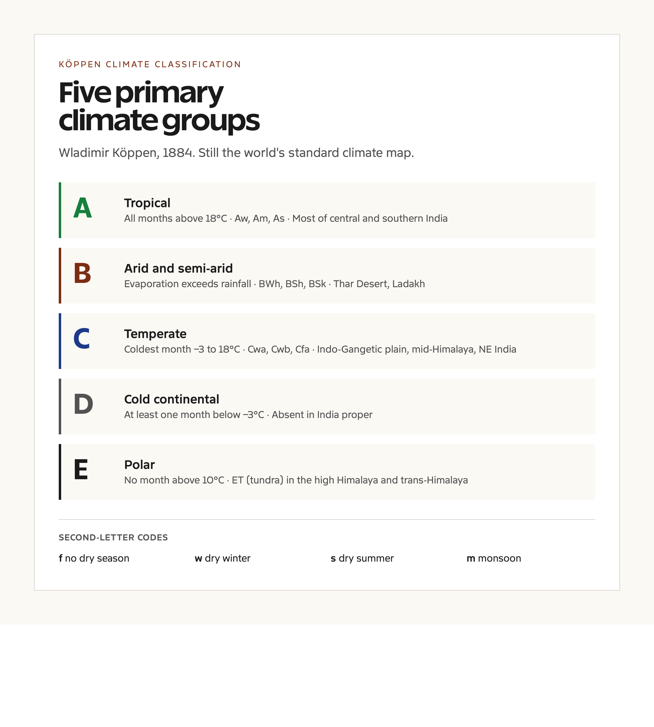
Wladimir Köppen’s classification remains the most widely used global climate-typing scheme. It uses two letters at the primary level. The first letter names the climate group based on temperature and rainfall patterns. A is tropical, with all months above 18 degrees Celsius. B is arid or semi-arid, defined by potential evaporation exceeding rainfall. C is temperate, with the coldest month between minus 3 and 18 degrees Celsius. D is cold continental, with at least one month below minus 3 degrees Celsius. E is polar, with no month above 10 degrees Celsius.
The second letter specifies the precipitation pattern. f indicates no dry season. w indicates a dry winter. s indicates a dry summer. m indicates a monsoon pattern, with a brief dry season followed by intense rainfall. A third letter, where it appears, refines the temperature, with a indicating hot summers, b warm summers, c cool summers, and d very cold winters.
Köppen’s system has been refined repeatedly. The Trewartha modification adjusts the tropical and temperate boundaries. The Thornthwaite system uses moisture balance instead of temperature. The IPCC uses its own ecoregion classification for climate projections. But for general geographic description, including in UPSC textbooks and atlases, Köppen remains the standard.
India’s Climate Types
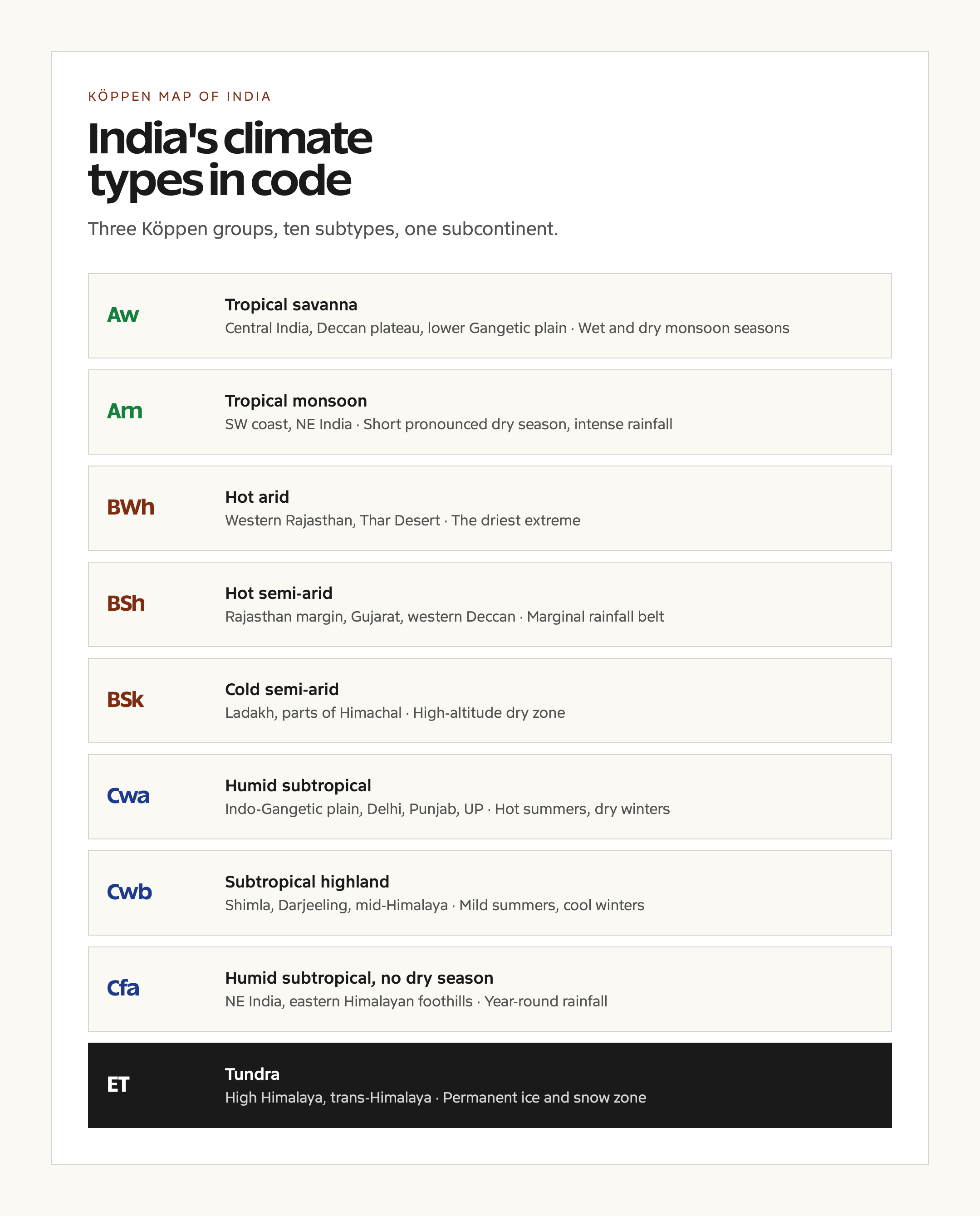
India sits across three of the Köppen groups, A, B, and C, which is unusually rich for a single country. The dominant climate is Aw, tropical savanna, which covers most of central and southern India, including the Deccan plateau, Tamil Nadu interior, and the lower Gangetic plains. Aw climates have a clear wet and dry season tied to the monsoon and mean annual temperatures around 25 to 28 degrees Celsius.
The southwest coast of India and parts of northeast India, including Mawsynram and Cherrapunji, fall under Am, the tropical monsoon climate, with a short pronounced dry season and an extremely intense rainy season. As, the rare tropical dry-summer climate, occurs in a small slice of the Tamil Nadu coast where the southwest monsoon is weak and the northeast monsoon delivers the bulk of the rainfall.
Western Rajasthan, including the Thar Desert, is BWh, hot arid. The surrounding semi-arid regions of Rajasthan, Gujarat, and the western Deccan are BSh, hot semi-arid. The cold semi-arid BSk type appears in Ladakh and parts of Himachal Pradesh. The Indo-Gangetic plain, including Delhi, Punjab, Haryana, and Uttar Pradesh, is mostly Cwa, humid subtropical with dry winters and hot summers. The middle Himalayan belt, including Shimla and Darjeeling, is Cwb, subtropical highland with mild summers. The northeast and eastern Himalaya foothills are Cfa, humid subtropical with no dry season. The high Himalaya, including Ladakh’s higher reaches and parts of the trans-Himalaya, is ET, tundra, with permanent ice and snow above the snow line.
The Indian Monsoon and Why It Matters
The Indian monsoon is the dominant feature of India’s climate system. The southwest monsoon runs from June to September and brings about 75 percent of India’s annual rainfall. The northeast monsoon, also called the retreating monsoon, runs from October to December and brings most of the rainfall to Tamil Nadu and the south Andhra coast. The southwest monsoon onsets over Kerala around 1 June and reaches Delhi around the end of June. The IMD’s Long Range Forecast for the southwest monsoon is the single most consequential climate forecast issued in India each year, with implications for agriculture, hydropower, drinking water, and inflation.
The monsoon is a seasonal reversal of the wind regime driven by the differential heating of the Asian continent and the Indian Ocean. The Tibetan Plateau acts as a high-altitude heat source in summer, generating low pressure that pulls moist air across the equator from the Indian Ocean. The El Niño Southern Oscillation, the Indian Ocean Dipole, and the Madden-Julian Oscillation are the three large-scale climate modes that modulate monsoon strength. The IMD now uses statistical and dynamical ensemble models for monsoon prediction.
Prelims Pointers
- Weather is the short-term atmospheric state; climate is the 30-year statistical average
- WMO climatological standard normal currently runs from 1991 to 2020
- IMD was founded in 1875, the oldest national meteorological service in South Asia
- WMO is a UN specialized agency, founded in 1950, headquartered in Geneva
- Köppen classification uses five primary groups: A tropical, B arid, C temperate, D cold, E polar
- India’s main Köppen types are Aw, Am, As, BSh, BSk, BWh, Cwa, Cwb, Cfa, and ET in the trans-Himalaya
- Southwest monsoon delivers about 75 percent of India’s annual rainfall
- Northeast monsoon brings most of Tamil Nadu’s rainfall during October to December
- All-India Mean Rainfall is approximately 1170 millimetres per year
- Mawsynram and Cherrapunji in Meghalaya are among the wettest places on earth, with annual rainfall above 11,000 millimetres
- The Tibetan Plateau is the central heat source that drives the southwest monsoon
- ENSO, IOD, and MJO are the three large-scale modes that modulate monsoon variability
Mains Practice Questions
- Distinguish between climate and weather and discuss the institutional framework in India for monitoring each. (GS Paper 1, 150 words)
- The Köppen climate classification has been called both indispensable and outdated. Critically examine its relevance for understanding India’s climate types. (GS Paper 1, 250 words)
- The Indian monsoon is climate, not weather. Explain this statement and discuss the implications for agricultural planning and disaster management. (GS Paper 1 / GS Paper 3, 250 words)
- Climate change is not a series of weather events but a shift in the statistics of weather. Examine this proposition with reference to India’s recent extreme weather record. (GS Paper 3, 250 words)
Way Forward
The first thing the public conversation needs is conceptual hygiene. Heat waves, floods, and cyclones are weather events. Their changing frequency, intensity, and seasonality is climate. Communicating this distinction matters because climate-adaptation funding and policy choices depend on it. The Ministry of Earth Sciences, the IMD, and the IPCC’s Indian participants need a clearer public-engagement strategy that does not blur the line every time a single extreme event grabs headlines.
The IMD has been upgrading its observation network steadily. The expansion of Doppler weather radars from 15 in 2014 to over 35 in 2024, the addition of automatic weather stations across districts, and the rollout of the Mausam app for mobile forecasts are useful steps. The next gap is climate services at the sub-district level, where adaptation decisions are actually made. India’s climate is regionally diverse, and a single national projection is not adequate for state and district planning. Useful related references include the greater one-horned rhinoceros habitat which depends on climate stability, the Indian Ocean tsunami of 2004 which illustrates the difference between meteorological and oceanographic warning systems, and the Kudankulam Nuclear Power Plant for the role of stable climate baselines in long-lived infrastructure planning.
Frequently Asked Questions
What is the basic difference between climate and weather?
Weather is the short-term atmospheric state at a specific location, measured in hours to days. Climate is the long-term statistical pattern of weather, conventionally averaged over a thirty-year period as set by the World Meteorological Organization. Weather is what is happening right now. Climate is what you expect over a long stretch of time.
Why is the averaging period for climate set at thirty years?
A thirty-year window is long enough to smooth out short-term variability such as El Niño years or unusual monsoon years, and short enough to be useful for current planning. The WMO standardized the thirty-year period in 1956, and it has been the international convention since. The current reference window runs from 1991 to 2020.
What is the Köppen climate classification?
The Köppen system is the most widely used scheme for classifying world climates. Developed by Wladimir Köppen in the late nineteenth century, it uses five primary groups, tropical, arid, temperate, cold, and polar, with letter codes that describe precipitation seasonality and temperature pattern. India sits across the tropical, arid, and temperate groups.
Which Köppen climate types are found in India?
India has Aw tropical savanna across most of central and southern India, Am tropical monsoon along the southwest coast and northeast, As on a small slice of the Tamil Nadu coast, BWh hot arid in the Thar Desert, BSh hot semi-arid across western Rajasthan and Gujarat, BSk cold semi-arid in Ladakh, Cwa humid subtropical across the Indo-Gangetic plains, Cwb subtropical highland in the middle Himalaya, Cfa humid subtropical in the northeast, and ET tundra in the high Himalaya.
What is the role of the IMD?
The India Meteorological Department, founded in 1875, is the national agency for weather forecasting, climate monitoring, cyclone warnings, and aviation meteorology. It is part of the Ministry of Earth Sciences. The IMD issues the Long Range Forecast for the southwest monsoon and operates the national Doppler weather radar network and automatic weather station grid.
What is the WMO and how does it work with the IMD?
The World Meteorological Organization is the United Nations specialized agency for weather, climate, and water. Founded in 1950 and headquartered in Geneva, it coordinates global meteorological observation, data sharing, and standards. The IMD is India’s national focal point for WMO programmes including the Global Atmosphere Watch and the World Weather Watch.
How does climate change relate to the climate vs weather distinction?
Climate change is a shift in the long-term statistics of weather. A single hot day or a single severe cyclone is not climate change. A measurable trend in the frequency, intensity, or seasonality of such events over decades is climate change. The IPCC and the IMD both work with the climate-statistics framing when assessing change.
What is the Indian monsoon and what causes it?
The Indian monsoon is the seasonal reversal of the wind regime that brings most of India’s annual rainfall during June to September. It is driven by the differential heating of the Asian continent and the Indian Ocean, anchored by the Tibetan Plateau as a high-altitude heat source. The southwest monsoon delivers about 75 percent of India’s annual rainfall.
What instruments are used to measure weather and climate?
The same instruments are used for both. Thermometers measure temperature, barometers measure pressure, hygrometers measure humidity, anemometers measure wind speed and direction, and rain gauges measure precipitation. Doppler weather radars measure precipitation distribution and storm structure. Climate analysis uses the long-run statistics of all these instrumental records.
How accurate are weather forecasts compared with climate projections?
Weather forecasts are skillful out to about ten days, with rapidly declining accuracy beyond five days. Climate projections work on decadal and centennial time scales, are expressed as probability ranges rather than precise forecasts, and are not used for daily operational decisions. The two have different aims and different uncertainty structures.
Tell Google you want more of this.
Add Anantam IAS as a preferred sourceOne tap, and this site shows up more often in your own Top Stories, AI Overviews and AI Mode. Remove it any time.