Mission Mausam: India’s Weather and Climate-Modelling Push (UPSC Science & Tech)
Mission Mausam is the Ministry of Earth Sciences' ₹2,000-crore push to make India 'weather-ready and climate-smart' — sharper, hyper-local forecasts now, and the science to eventually manage weather later. Here is what it actually funds, what it targets, and where the science gets honest about its limits.
Every Indian monsoon turns weather forecasting from a convenience into a question of life and death. A cloudburst over Wayanad, a heatwave that empties a city’s hospitals, lightning that kills more people in India each year than cyclones do, a cyclone that has to be tracked to the right stretch of coast so the right districts can be cleared — all of it rests on how early and how precisely the forecast lands. And the honest truth, until recently, is that India’s models could only see the weather in 12-kilometre blocks, which is far too coarse to tell one valley from the next. Mission Mausam is the Ministry of Earth Sciences’ answer to that gap: a ₹2,000-crore push, approved by the Union Cabinet on 11 September 2024, to make the country, in the government’s own phrase, “weather-ready and climate-smart.”
It’s a deliberately big claim, and it has two halves. The near-term half is forecasting — sharper, faster, hyper-local predictions that can eventually reach the level of an individual Panchayat. The longer-term half is the ambitious one that grabbed the headlines: weather management, the science of nudging the atmosphere itself through cloud seeding to enhance rain, suppress hail, or clear fog. Prime Minister Narendra Modi formally launched the mission on 14 January 2025, the 150th anniversary of the India Meteorological Department, which tells you how the government wants it read — not as one more scheme, but as the next chapter in a century and a half of Indian meteorology. For UPSC, it sits squarely in GS Paper 3, touching science and technology, disaster management, and the environment all at once.
What Mission Mausam Is and Why It Was Launched
Let’s define it cleanly before the acronyms pile up. Mission Mausam is a national initiative of the Ministry of Earth Sciences (MoES), to be run during 2024-2026 with an outlay of ₹2,000 crore, whose stated goal is to make Bharat a “weather-ready and climate-smart” nation. That’s the whole thesis in one line: better observation and modelling so the country can both predict extreme weather earlier and, over time, manage some of it. It is not a single instrument or a single lab. It is a coordinated upgrade of India’s entire weather-and-climate machinery — the sensors that watch the sky, the supercomputers that crunch the data, the models that turn data into forecasts, and the apps and alerts that get those forecasts to a farmer or a fisherman in time to act.
The reason it was launched now comes down to two problems the MoES itself spells out. First, India’s observations are sparse — too thin in both space and time to capture the small, violent weather that climate change is making more common. Second, and more technical, the horizontal resolution of India’s Numerical Weather Prediction (NWP) models — the grid the computer divides the country into — was 12 kilometres. At 12 km, a model literally cannot “see” a cloudburst forming over one ridge while the next valley stays dry. India had already made real progress: short-to-medium-range forecasts (up to about five days) improved roughly 40-50% in accuracy over the past decade compared with the decade before. But a warming atmosphere is becoming more chaotic, throwing up isolated heavy-rain events, sudden localized droughts, and the cloudbursts, thunderstorms, lightning and squalls that, as MoES admits, are the “least understood” phenomena over the Indian region. Mission Mausam is the attempt to close that understanding gap with hardware, computing and science all at once.
It helps to know who is actually doing the work. Three MoES institutions lead the mission, with a clean division of labour. The India Meteorological Department (IMD) — the 150-year-old national weather agency — handles observations, services, decision-support systems and dissemination, the part the public sees. The Indian Institute of Tropical Meteorology (IITM) in Pune runs the research side: specialised field campaigns, testbeds, process studies and modelling, including the cloud-seeding science. And the National Centre for Medium-Range Weather Forecasting (NCMRWF) does the heavy data work — data assimilation, which means folding millions of new observations into the models, and “seamless” prediction across timescales. Other MoES bodies fill in the edges: INCOIS, NIOT and NCPOR cover the oceans and polar regions, while the Central Water Commission, Geological Survey of India and the Defence Geoinformatics Research Establishment link in for floods, landslides and avalanches.
What the Mission Actually Funds and Targets
This is where Mission Mausam stops being a slogan and becomes a shopping list — and the list is worth knowing in detail, because UPSC rewards the candidate who can name the instruments rather than wave at “modern technology.” The mission’s first-phase deliverables include 50 new Doppler Weather Radars (DWRs), which track rain and storm motion in real time; 60 radiosonde/radiowind (RS/RW) systems, the balloon-borne sensors that profile the atmosphere from the ground up; 100 disdrometers, which measure raindrop size and intensity; 10 wind profilers; 25 radiometers; and 10 marine automatic weather stations with upper-air observation, plus a dedicated ocean research station. To these are added next-generation satellite instruments and a national field campaign — the goal, in MoES’s words, being that “no weather system will go undetected.”
But sensors only generate data. Turning that flood of data into a sharper forecast needs two more things, and the mission funds both. The first is raw computing — high-performance computers (HPC) and storage powerful enough to run finer models and assimilate satellite data without delay. The second is a new way of forecasting: data-driven methods, meaning AI and machine-learning models trained to spot patterns that traditional physics-based models miss. The headline targets follow directly. The NWP model’s resolution is to sharpen from 12 km down to 6 km, fine enough for that long-promised “Panchayat-level” forecast. Nowcasting — the very short-range warning of imminent weather — is to speed up from updates every three hours to every one hour. Overall short-to-medium-range accuracy is targeted to improve by roughly 5-10%, with a similar 5-10% gain in air-quality forecasts for major metros, and forecasts stretching across timescales from a few days out to extended-range and seasonal horizons of 10-15 days and beyond.
Then there is the part that made the news. Mission Mausam funds the first phase of a cloud chamber at IITM Pune — a sealed, cylindrical facility into which scientists inject water vapour and aerosols, then control humidity and temperature to grow a cloud under laboratory conditions. The point is to study, in a sustained and repeatable way, exactly how droplets form into rain and how “seed” particles trigger that process. This is the research foundation for weather modification: cloud seeding for rain enhancement, hail suppression and fog dispersal, tested through drone- and ground-based burner experiments and numerical simulations that fine-tune the seeding methods. So the mission’s two halves connect here — the cloud chamber is where India’s ambition to eventually manage weather gets its scientific grounding, rather than being attempted blind in the open sky.

How It Works on the Ground
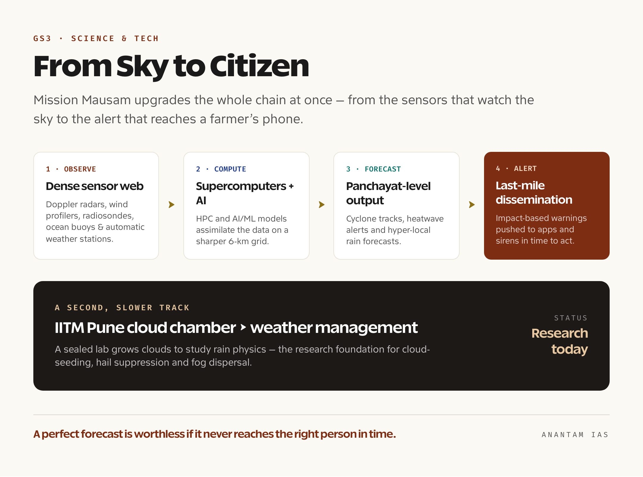
A forecast is only as good as the action it triggers, so it’s worth following the chain from sky to citizen. It starts with observation: the new radars, balloons, buoys, profilers and satellites blanket the country and its surrounding oceans far more densely than before, and at higher frequency. That dense web of readings flows to NCMRWF, where data assimilation stitches it into the model’s picture of the current atmosphere — the more accurate that starting snapshot, the more accurate every forecast that follows. The model, now running at a 6-km grid on the new supercomputers and corrected by AI/ML tools, projects forward across timescales. IMD then converts the raw model output into something usable — a cyclone track, a heatwave alert, a Panchayat-level rain forecast, an air-quality advisory for a metro.
The last and most underrated link is dissemination. A perfect forecast that never reaches the right person in time is worthless, which is why the mission explicitly funds a state-of-the-art dissemination system for “last-mile connectivity,” along with a GIS-based automated Decision Support System for advisories and visualisation at IMD’s headquarters and regional centres. The idea is “Impact-Based Forecasting” — not just telling people it will rain 100 mm, but telling a district which low-lying wards will flood and what to do. Nowcasting at one-hour intervals matters most here: for a sudden thunderstorm or lightning event, three hours of warning is often too late, while one hour, pushed through mobile apps and alerts, can clear a field or a fishing fleet. The weather-management piece runs in parallel and slower — the cloud chamber and seeding experiments are research today, with operational fog dispersal at airports, hail suppression over orchards, and rain enhancement over deficit basins as the eventual, carefully-tested goal.
Why It Matters for India
Strip away the technology and Mission Mausam is, at heart, a disaster-risk-reduction project, and that is where its value is clearest. India loses thousands of lives a year to weather it could forecast better — lightning alone kills more Indians annually than any other natural hazard, and heatwaves, floods and cloudbursts add to the toll. Sharper, earlier, hyper-local warnings translate directly into evacuations that happen in time, reservoirs released before a flood crest, and outdoor workers warned off a field before a lightning storm. India’s cyclone record already shows what good forecasting buys: deaths from major cyclones have fallen dramatically over two decades precisely because IMD’s tracks and the resulting evacuations got better. Mission Mausam is an attempt to extend that success from cyclones, which are relatively large and slow, to the small, fast killers — the cloudburst and the squall — that current models miss.
The economic case is just as broad, because almost every sector runs on weather. Agriculture, still the livelihood of nearly half of Indians, lives and dies by the monsoon’s timing and a farmer’s ability to plan sowing, irrigation and harvest around it. Aviation needs precise wind and fog forecasts; ports and shipping need accurate sea-state warnings; the power sector, increasingly dependent on solar and wind, needs to predict generation hour by hour; water managers need to know how much will fall in which basin. The mission lists agriculture, aviation, defence, water resources, power, renewable energy, tourism, pilgrimage, smart cities, ports, railways, health services and more among its beneficiaries — which is another way of saying that a few percentage points of forecast accuracy, spread across the whole economy, is worth far more than ₹2,000 crore. And it carries a quieter geopolitical dividend: the mission aims to make India a top-tier forecast provider to other countries of the Global South, the way IMD already issues warnings for neighbours in the Indian Ocean region. It also fits a wider Indian Earth-observation push, alongside the INSAT meteorological satellites and IMD’s own Vision-2047 climate-adaptation roadmap, released on the same January 2025 anniversary.
Challenges and the Way Forward
A mission this ambitious deserves an honest accounting of where it can stumble, and the cloud-seeding ambition is the first place to be careful. Weather modification is genuinely promising but nowhere near settled science. The World Meteorological Organization’s own position is cautious: while there’s now solid evidence that one specific technique — wintertime seeding of mountain clouds — can work, proving cause and effect for seeding at the local scale remains hard, because the atmosphere is so variable that you can rarely tell whether the rain you got was the rain you made. The WMO also notes that unintended consequences — downwind “rain-stealing” effects, the persistence of silver iodide in soil, ecological impacts — have not been demonstrated but cannot be ruled out. So the realistic framing, and the one to use in an answer, is that cloud seeding is neither a fix for climate change nor an on-demand rain service. India is right to build the cloud chamber and study it rigorously; it would be wrong to oversell it.
The forecasting half has its own hard problems. Data assimilation only helps if the new data is clean and the model can absorb it fast — quality control and timely satellite reception are explicit mission concerns for a reason. Tropical weather is intrinsically harder to model than the mid-latitudes, so even a 6-km grid won’t make cloudbursts trivially predictable. There are transboundary gaps too: weather doesn’t respect borders, and India’s forecasts depend partly on observations from regions it can’t sense directly. And the last-mile problem is as much social as technical — a Panchayat-level forecast only saves lives if it reaches people in a language and form they trust and act on, which means investing in local dissemination and weather literacy, not just radars. The way forward, then, is sequencing and candour: deliver the forecasting gains first, where the science is sound and the payoff is immediate; treat weather management as a long research horizon with transparent results; and pair every new instrument with the human and institutional plumbing that turns a forecast into a decision. Phase-II, planned for 2026-31, is where that maturing should show.
For Your Mains Answer
Mission Mausam is a clean fit for GS Paper 3, which covers “developments in science and technology and their applications,” disaster management, and the conservation and challenges of the environment. It can anchor a science-and-technology question on indigenous capability, a disaster-management question on early warning and risk reduction, or an environment question on climate adaptation — and the strongest answers will show how it sits at the junction of all three. The trick is to treat it as a case study of how better data and computing become better governance, not just as a list of gadgets.
How to Build the Answer
Open with the problem, not the scheme: India’s models could only resolve weather in 12-km blocks while climate change sharpens extreme events. Then introduce Mission Mausam as the response — the ₹2,000-crore MoES mission, its “weather-ready and climate-smart” goal, and the IMD-IITM-NCMRWF division of labour. Move to the concrete build-out (radars, profilers, supercomputers, AI/ML, the cloud chamber) and the targets (12 km to 6 km, three-hour to one-hour nowcasts, 5-10% accuracy). Devote a clear block to significance across disaster management, agriculture and the economy, and a balanced block to limits — cloud-seeding uncertainty, data assimilation, transboundary and last-mile gaps. That arc — problem, response, mechanism, significance, limits — works for almost any scheme question.
Common Mistakes to Avoid
Don’t confuse the two dates: the Cabinet approved Mission Mausam on 11 September 2024, and the PM launched it on 14 January 2025 alongside IMD’s 150th anniversary. Don’t oversell weather modification as a solved technology — that single error signals you haven’t read the science. Don’t reduce the mission to “AI for weather”; the observation hardware and the cloud chamber are equally central. And don’t forget dissemination — many candidates stop at the forecast and miss the last-mile point that actually saves lives.
A Compact Answer Spine
12-km models + worsening extremes = forecasting gap → Mission Mausam (MoES, ₹2,000 cr, 2024-26, “weather-ready and climate-smart”) → who runs it (IMD observations, IITM research, NCMRWF assimilation) → what it funds (50 DWRs, profilers, radiosondes, buoys, HPC, AI/ML, IITM cloud chamber) → targets (12→6 km, 3→1 hr nowcast, 5-10% accuracy, Panchayat-level) → significance (disaster risk reduction, agriculture, aviation, power, Global South leadership) → limits (cloud-seeding uncertainty, assimilation, transboundary, last-mile) → way forward (forecasting first, weather management as research, Phase-II 2026-31).
Diagram or Flowchart Idea
Draw a left-to-right pipeline: a cluster of sensors (radar, balloon, buoy, satellite icons) → a supercomputer box labelled “data assimilation + AI/ML, 6-km grid” → a forecast output (cyclone track / Panchayat rain) → a phone or siren labelled “last-mile alert.” Branch one arrow off the sensor cluster down to a small “cloud chamber → weather management” box to show the second, slower track. A clean pipeline like this earns marks fast and proves you understand the system, not just the name.
A Balanced-Conclusion Line
A line that lands: “Mission Mausam’s real promise lies less in commanding the clouds than in reading them better — and a forecast that reaches the right village in time will save more lives than any seeded raincloud, which is exactly where the mission should keep its weight.”
How to Use Data Without Cramming
Pick three anchors and stop: ₹2,000 crore over 2024-26; the 12-km-to-6-km resolution jump; and the three-hour-to-one-hour nowcasting target. Add one institution detail (IMD-IITM-NCMRWF) and one limit (the WMO’s caution on proving cloud-seeding cause and effect), and you sound like someone who has read the mission document rather than a coaching summary. Resist listing all fifty radars and twenty-five radiometers — examiners read for judgment, not inventory.
FAQ
What is Mission Mausam and when was it approved? Mission Mausam is a national initiative of the Ministry of Earth Sciences to make India “weather-ready and climate-smart” through far better weather forecasting and, eventually, weather management. The Union Cabinet approved it on 11 September 2024 with an outlay of ₹2,000 crore for 2024-26, and Prime Minister Modi formally launched it on 14 January 2025, the 150th anniversary of the India Meteorological Department.
Which institutions are implementing Mission Mausam? Three Ministry of Earth Sciences bodies lead it. The India Meteorological Department (IMD) handles observations, services and dissemination; the Indian Institute of Tropical Meteorology (IITM), Pune, runs the research, field campaigns and cloud-seeding science, including a new cloud chamber; and the National Centre for Medium-Range Weather Forecasting (NCMRWF) handles data assimilation and prediction. Ocean and polar institutes such as INCOIS, NIOT and NCPOR support them.
What does Mission Mausam actually fund? A large hardware and computing build-out: new-generation Doppler radars, radiosondes, wind profilers, disdrometers, radiometers, ocean buoys and marine automatic weather stations, next-generation satellite instruments, high-performance supercomputers, AI/ML forecasting models, and the first phase of a cloud chamber at IITM Pune for cloud-seeding research. It also funds a last-mile dissemination and decision-support system.
What are the main targets and risks of Mission Mausam? The targets are sharper and faster forecasts: improving model resolution from 12 km to 6 km for Panchayat-level forecasts, speeding nowcasts from three hours to one hour, and raising short-to-medium-range accuracy by about 5-10%. The main risks are scientific — cloud seeding’s effectiveness is hard to prove and may carry downwind effects — plus practical challenges in data assimilation, transboundary observation gaps, and reaching the last mile in time.
Practice Questions
Prelims MCQs
- With reference to Mission Mausam, consider the following statements:
1. It is an initiative of the Ministry of Earth Sciences.
2. It was approved by the Union Cabinet with an outlay of ₹2,000 crore.
3. It aims to improve the Numerical Weather Prediction model resolution from 12 km to 6 km.
Which of the statements given above are correct?
(a) 1 and 2 only
(b) 2 and 3 only
(c) 1 and 3 only
(d) 1, 2 and 3
Answer: (d) Mission Mausam is an MoES initiative approved with a ₹2,000-crore outlay and explicitly targets sharpening NWP model resolution from 12 km to 6 km, so all three are correct. - The three Ministry of Earth Sciences institutions primarily implementing Mission Mausam are:
(a) ISRO, IMD and NCMRWF
(b) IMD, IITM and NCMRWF
(c) IMD, INCOIS and ISRO
(d) IITM, NIOT and NCPOR
Answer: (b) The mission is led by the India Meteorological Department, the Indian Institute of Tropical Meteorology and the National Centre for Medium-Range Weather Forecasting; INCOIS, NIOT and NCPOR play supporting ocean and polar roles. - The cloud chamber being set up under Mission Mausam is located at which institution?
(a) IMD, New Delhi
(b) NCMRWF, Noida
(c) IITM, Pune
(d) INCOIS, Hyderabad
Answer: (c) The first phase of the cloud chamber, a sealed facility to study how droplets form into rain for cloud-seeding research, is being built at the Indian Institute of Tropical Meteorology in Pune. - Consider the following objectives associated with Mission Mausam:
1. Improving nowcasting frequency from three hours to one hour.
2. Achieving Panchayat-level weather forecasts.
3. Eliminating the monsoon’s year-to-year variability.
How many of the above are stated objectives of the mission?
(a) Only one
(b) Only two
(c) All three
(d) None
Answer: (b) Faster nowcasting and Panchayat-level forecasting are stated goals; eliminating monsoon variability is not — the mission seeks to forecast and manage weather, not abolish natural variability. - With reference to cloud seeding as studied under Mission Mausam, consider the following statements:
1. It is a proven, on-demand method to produce rain anywhere.
2. The World Meteorological Organization notes that proving cause and effect at the local scale remains difficult.
3. India is building a cloud chamber to research the underlying cloud physics.
Which of the statements given above are correct?
(a) 1 and 3 only
(b) 2 and 3 only
(c) 1 and 2 only
(d) 1, 2 and 3
Answer: (b) Cloud seeding is not a proven on-demand technique, so statement 1 is wrong; the WMO does caution that local-scale cause and effect is hard to prove, and India is building the IITM cloud chamber to study cloud physics.
Mains Practice Questions
- “Mission Mausam is as much a disaster-management programme as a science-and-technology one.” Examine the mission’s design and assess how far it can reduce India’s weather-related disaster risk. (15 marks, 250 words)
- Discuss how improved observation, high-performance computing and AI/ML together aim to deliver “Panchayat-level” weather forecasting in India, and evaluate the challenges in achieving it. (15 marks, 250 words)
- Weather modification through cloud seeding promises much but remains scientifically contested. Critically analyse the case for and against India’s investment in cloud-seeding research under Mission Mausam. (15 marks, 250 words)
- The value of a weather forecast depends on the last mile. Comment on the dissemination and decision-support components of Mission Mausam and their importance for impact-based forecasting. (10 marks, 150 words)
- Evaluate how Mission Mausam contributes to India’s climate adaptation and its ambition to be a weather-services leader in the Global South, and identify the gaps it must close. (15 marks, 250 words)