Nile River — Course, Tributaries, Significance, and Comparison with Indian Rivers
Complete guide to the Nile River covering White and Blue Nile, countries it flows through, Aswan Dam, significance for Egypt, and UPSC-relevant comparisons.
The Nile River has traditionally been considered the longest river in the world, stretching approximately 6,650 km from its remotest headstream in Burundi to its delta on the Mediterranean Sea in Egypt. It is the lifeblood of northeastern Africa, sustaining civilisations for millennia and remaining central to the water politics of the region today. For UPSC aspirants, the Nile appears in World Geography, Ancient Civilisations, and comparative questions on river systems.
The Longest River Debate
The Nile's status as the world's longest river has been challenged by the Amazon River in South America. The dispute centres on how the source of each river is measured:
| River | Traditional Length | Claim |
|---|---|---|
| Nile | ~6,650 km | Longest by most standard measurements |
| Amazon | ~6,400 km (some estimates say 6,992 km) | Brazilian and Peruvian surveys claim a longer course when measured from a different headwater |
Most atlases and international bodies continue to list the Nile as the longest, but the matter remains debated. The Amazon is indisputably the largest river by discharge volume (far exceeding the Nile).
Source and Course
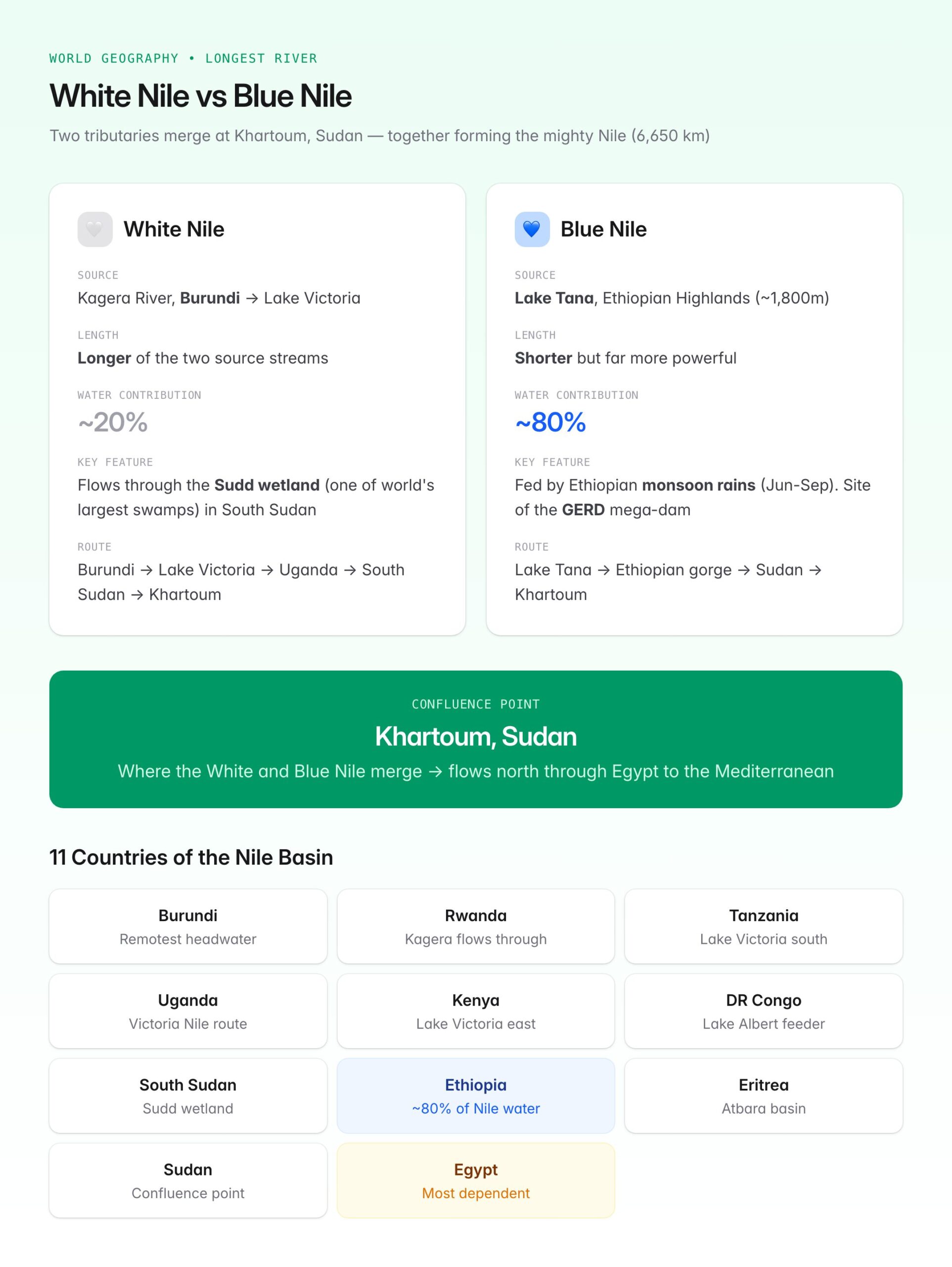
The Nile is formed by the confluence of two major tributaries: the White Nile and the Blue Nile, which meet at Khartoum, the capital of Sudan.
White Nile
- The White Nile is considered the longer of the two source streams.
- Its most distant source is the Kagera River, which originates in Burundi and flows into Lake Victoria (the largest lake in Africa, shared by Uganda, Kenya, and Tanzania).
- From Lake Victoria, the river flows northward through Uganda as the Victoria Nile, passes through Lake Kyoga and Lake Albert, then enters South Sudan as the Albert Nile (later called Bahr el-Jebel).
- In South Sudan, it passes through the vast Sudd wetland, one of the world's largest swamp systems, before becoming the White Nile proper and flowing into Sudan.
Blue Nile
- The Blue Nile originates from Lake Tana in the Ethiopian Highlands at about 1,800 metres elevation.
- Despite being shorter, it contributes approximately 80 per cent of the Nile's water during the flood season (June-September), fed by Ethiopian monsoon rains.
- It flows through a spectacular gorge in Ethiopia before entering Sudan and meeting the White Nile at Khartoum.
After Khartoum
- North of Khartoum, the river receives its last significant tributary, the Atbara River (also from Ethiopia).
- The Nile then flows through the Nubian Desert in northern Sudan, forming an S-shaped curve with six cataracts (rocky rapids).
- It enters Egypt at the border town of Wadi Halfa and flows northward through the entire length of Egypt.
- Near Cairo, the Nile splits into two main distributaries — the Rosetta Branch and the Damietta Branch — forming the Nile Delta, one of the world's largest river deltas, before emptying into the Mediterranean Sea.
Countries of the Nile Basin
The Nile basin spans 11 countries, making it one of the most internationally shared river systems:
| Country | Role in Nile System |
|---|---|
| Burundi | Source of the Kagera (remotest Nile headwater) |
| Rwanda | Kagera River flows through |
| Tanzania | Lake Victoria's southern shore; Kagera inflow |
| Uganda | Victoria Nile flows through; Lake Victoria, Lake Albert |
| Kenya | Lake Victoria's eastern shore |
| DR Congo | Minor western contribution to Lake Albert |
| South Sudan | White Nile flows through the Sudd wetland |
| Sudan | Confluence of White and Blue Nile at Khartoum |
| Ethiopia | Source of Blue Nile (Lake Tana) and Atbara; ~80% of Nile water |
| Eritrea | Minor contribution to Atbara basin |
| Egypt | Lower Nile; delta; the most downstream and dependent nation |
The Aswan Dam
The Aswan High Dam (Sadd el-Aali), completed in 1970 with Soviet assistance, is one of the world's largest embankment dams. It is located near Aswan in southern Egypt.
Purpose and Impact
- Flood control: Ended the annual Nile floods that had shaped Egyptian agriculture for millennia.
- Irrigation: Enabled year-round irrigation and the conversion of seasonal (basin) irrigation to perennial irrigation.
- Hydroelectricity: The dam generates significant hydroelectric power for Egypt.
- Lake Nasser: The reservoir behind the dam, Lake Nasser, is one of the world's largest artificial lakes (~5,250 sq km), extending into Sudan (where it is called Lake Nubia).
Negative Consequences
- Silt deprivation: The dam traps the nutrient-rich silt that previously fertilised downstream farmland, increasing dependence on chemical fertilisers.
- Delta erosion: Without sediment replenishment, the Nile Delta is shrinking due to Mediterranean Sea erosion.
- Displacement: The dam's construction required relocating over 100,000 Nubians and the rescue of the Abu Simbel temples (relocated by UNESCO in a landmark international effort).
- Waterlogging and salinity in downstream areas.
The Grand Ethiopian Renaissance Dam (GERD)
The GERD, under construction on the Blue Nile in Ethiopia since 2011, is a major source of geopolitical tension. When fully operational, it will be Africa's largest hydroelectric dam. Egypt fears reduced water flow, while Ethiopia argues it has the sovereign right to develop its water resources. Sudan holds a middle position. Negotiations continue under African Union mediation.
Significance of the Nile
- Ancient Egyptian Civilization: The Nile's annual flooding deposited fertile silt, enabling agriculture in an otherwise desert region. Ancient Egypt's entire social, economic, and religious life revolved around the river. The Greek historian Herodotus famously called Egypt the "gift of the Nile."
- Modern agriculture: Egypt and Sudan depend almost entirely on the Nile for irrigation.
- Geopolitics: Water-sharing among 11 nations makes the Nile a flashpoint for potential conflict, particularly between Egypt, Ethiopia, and Sudan.
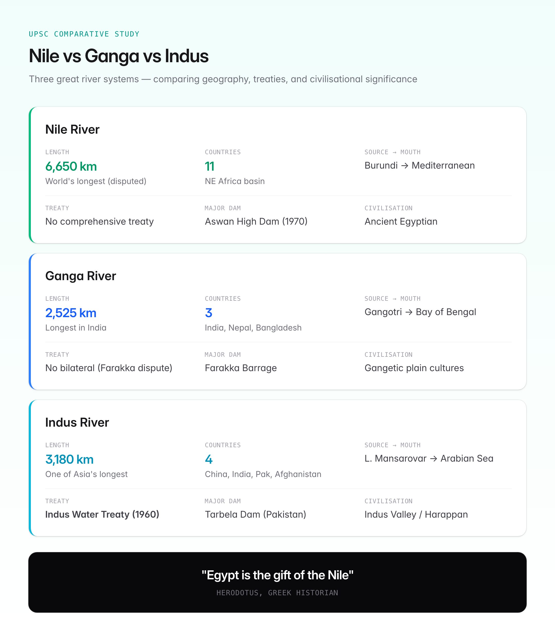
Comparison with Indian Rivers for UPSC
| Feature | Nile | Ganga | Indus |
|---|---|---|---|
| Length | ~6,650 km | ~2,525 km | ~3,180 km |
| Countries | 11 | 3 (India, Nepal, Bangladesh) | 4 (China, India, Pakistan, Afghanistan) |
| Source | Lake Victoria / Kagera (Burundi) | Gangotri Glacier | Near Lake Mansarovar, Tibet |
| Drains into | Mediterranean Sea | Bay of Bengal | Arabian Sea |
| Key treaty | No comprehensive basin treaty | No bilateral treaty (Farakka dispute exists) | Indus Water Treaty (1960) |
| Major dam | Aswan High Dam | Farakka Barrage | Tarbela Dam (Pakistan) |
| Ancient civilisation | Egyptian Civilization | Ganges plain civilisations | Indus Valley Civilization |
UPSC Relevance
GS Paper I: World Geography (African river systems, transboundary water disputes), Ancient Civilisations. GS Paper II: International relations (water diplomacy, GERD dispute).
Key Prelims facts:
- The Nile is traditionally the longest river in the world at approximately 6,650 km.
- It is formed by the White Nile (longer) and Blue Nile (contributes ~80% of water), meeting at Khartoum, Sudan.
- The White Nile's remotest source is the Kagera River in Burundi, flowing into Lake Victoria.
- The Blue Nile originates at Lake Tana in Ethiopia.
- The Nile basin spans 11 countries in northeastern Africa.
- The Aswan High Dam (1970) was built with Soviet help; its reservoir is Lake Nasser.
- Herodotus called Egypt the "gift of the Nile."
- The GERD on the Blue Nile in Ethiopia is a major source of Egypt-Ethiopia-Sudan tensions.
- The Nile Delta is formed near Cairo with the Rosetta and Damietta branches.