Political Map of India 2026: 28 States, 8 UTs & Official PDF
Study the 2026 political map of India with 28 states, 8 Union Territories, capitals and borders. Download English and Hindi PDFs and verify the official map.
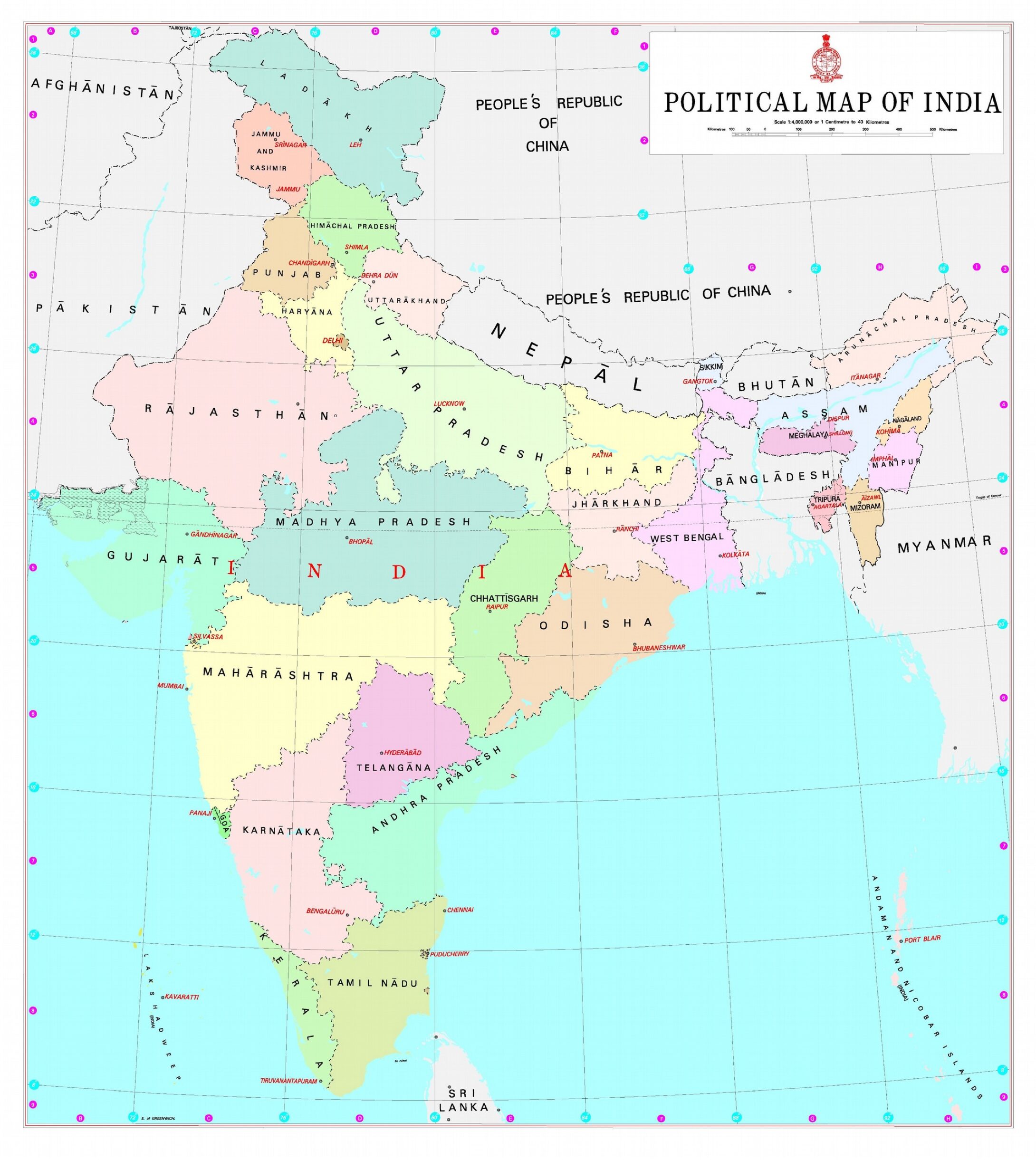
The political map of India 2026 shows 28 states and 8 Union Territories, together with their capitals, internal boundaries and international frontiers. The current state-UT count has remained unchanged since the 2020 merger of Dadra and Nagar Haveli with Daman and Diu.
Use an official map when studying disputed or sensitive boundaries. Commercial diagrams can be useful for revision, but they should not replace the Government of India’s authoritative boundary depiction.
The Survey of India political-map page currently provides the English 13th Edition/2026 and Hindi 10th Edition/2026 as free downloads. The existing English and Hindi study PDFs on this page are preserved below for convenient revision.
Quick Facts at a Glance
| Parameter | Value |
|---|---|
| Total States | 28 |
| Total Union Territories | 8 |
| Total Land Area | 3,287,263 sq km |
| Longest Land Border | with Bangladesh (4,096 km) |
| Coastline Length | 7,516.6 km |
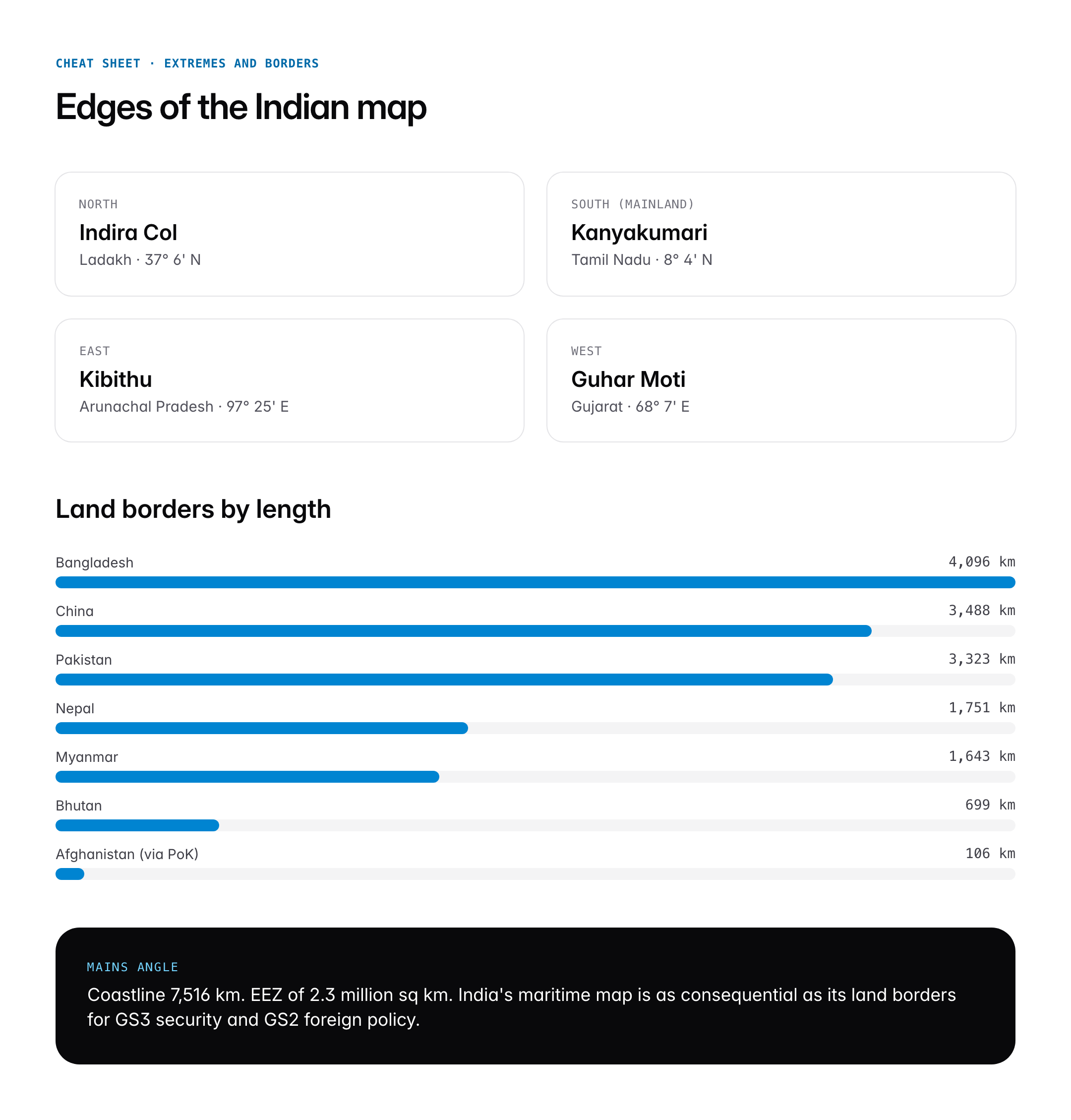
| Northernmost Point | Indira Col, Ladakh |
| Southernmost Point (mainland) | Kanyakumari, Tamil Nadu |
| Southernmost Point (territory) | Indira Point, Great Nicobar |
| Easternmost Point | Kibithu, Arunachal Pradesh |
| Westernmost Point | Guhar Moti, Gujarat |
| Largest State (area) | Rajasthan (342,239 sq km) |
| Smallest State (area) | Goa (3,702 sq km) |
| Most Populous State | Uttar Pradesh |
| Latest Reorganisation | J&K Reorganisation Act, 2019 |
Background and Historical Context
India’s political map is the product of a seven-decade process of reorganisation that began almost immediately after independence. At the moment of the transfer of power on 15 August 1947, the subcontinent was an untidy patchwork of British Indian provinces and more than 560 princely states. Sardar Vallabhbhai Patel and V. P. Menon, through the instrument of accession and later the States Reorganisation process, stitched these units into a single political unit. The first major redraw came with the States Reorganisation Act, 1956, which adopted language as the basis for creating Andhra Pradesh, Kerala, Karnataka (then Mysore), and Maharashtra-Gujarat (the bilingual Bombay State, later split in 1960).
A second wave in the 1960s and 1970s created Nagaland (1963), Haryana (1966 from Punjab), Himachal Pradesh (statehood 1971), and the Northeastern states of Manipur, Meghalaya, and Tripura (1972). Sikkim merged with India in 1975 through the 36th Constitutional Amendment. Arunachal Pradesh and Mizoram attained statehood in 1987 alongside Goa. The third wave in 2000 produced Chhattisgarh, Jharkhand, and Uttarakhand. The fourth and most recent restructuring began with the creation of Telangana on 2 June 2014 and culminated in the bifurcation of Jammu and Kashmir on 31 October 2019, which created the Union Territories of J&K and Ladakh. Each of these events required a constitutional amendment, boundary commissions, and fiscal redistribution under the Finance Commission formula.
Key Features of the Political Map
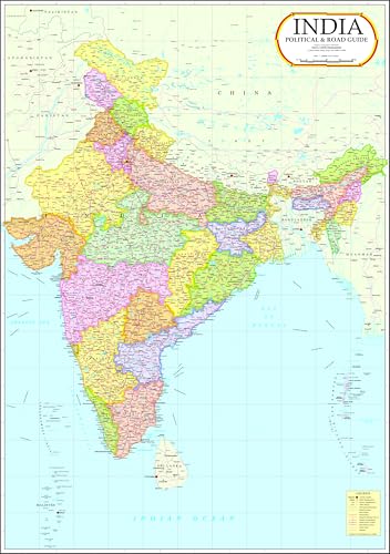
India Political Wall Map, laminated 140 × 100 cm (Vidya Chitr Prakashan)
- Laminated wall map, 4 ft 7 in × 3 ft 3 in (140 × 100 cm)
- Certified by Survey of India, so the boundaries are the official ones
- Big enough to read from the desk chair
The 28 States
The 28 states are constitutional units exercising legislative power on the State List and Concurrent List under Schedule VII of the Constitution. Each state has a Governor appointed by the President, a Chief Minister heading the Council of Ministers, and a unicameral or bicameral legislature. Six states currently have a Legislative Council (Vidhan Parishad): Andhra Pradesh, Bihar, Karnataka, Maharashtra, Telangana, and Uttar Pradesh.
The 8 Union Territories
Union Territories are governed directly by the Union through an Administrator or Lieutenant Governor. The eight UTs are Andaman and Nicobar Islands, Chandigarh, Dadra and Nagar Haveli and Daman and Diu, Delhi (National Capital Territory), Jammu and Kashmir, Ladakh, Lakshadweep, and Puducherry. Of these, Delhi, J&K, and Puducherry have their own Legislative Assemblies under special constitutional arrangements (Articles 239AA, 239A, and the J&K Reorganisation Act).
International Borders
India shares land boundaries with seven countries: Bangladesh (4,096 km), China (3,488 km), Pakistan (3,323 km), Nepal (1,751 km), Myanmar (1,643 km), Bhutan (699 km), and Afghanistan (106 km, currently under PoK). The maritime neighbours include Sri Lanka across the Palk Strait and the Maldives in the Arabian Sea.
Major River Systems on the Map
The political map overlays on a dense hydrographic network. The Sindhu (Indus) system drains Ladakh and flows out through Pakistan. The Ganga-Brahmaputra-Meghna system dominates the northern and eastern plains. Peninsular rivers include the Godavari, Krishna, Kaveri, Narmada, and Tapi. Every serious map study cross-references rivers with state boundaries because inter-state disputes (Cauvery, Krishna, Mahanadi, Ravi-Beas) track precisely along these lines.
Capitals, Largest Cities, and Seats
Not every state capital is the largest city. Gandhinagar is the capital of Gujarat, but Ahmedabad is larger. Bhopal is the capital of Madhya Pradesh, but Indore is larger. Himachal Pradesh has two capitals by convention: Shimla (summer) and Dharamshala (winter). Maharashtra also has a winter capital at Nagpur.
Significance for UPSC and General Knowledge
- Political map questions appear almost every year in Prelims, often as matching-type or capital-state identification questions.
- Mains GS1 Geography requires spatial literacy for answers on regional planning, resource distribution, and internal migration.
- GS2 Polity questions on federalism, Article 3 (formation of new states), and inter-state disputes rest on map fluency.
- GS3 questions on river-linking, agriculture, and mineral belts demand the ability to locate resources by state.
- Essay paper candidates who cite regional diversity score higher when they can name specific states and UTs.
- Interview stage frequently tests the candidate’s home state, cadre preference geography, and neighbouring country awareness.
Detailed Analysis: State-wise Distribution
India’s states are not uniform in scale or character. By area, the five largest states, Rajasthan, Madhya Pradesh, Maharashtra, Uttar Pradesh, and Gujarat, together cover roughly 45 percent of the land mass. By population, Uttar Pradesh, Maharashtra, Bihar, West Bengal, and Madhya Pradesh account for close to half of India’s one-point-four billion people. This asymmetry shapes everything from Lok Sabha seat distribution to Finance Commission transfers.
The Northeast occupies a special place on the political map. Seven sister states (Arunachal Pradesh, Assam, Manipur, Meghalaya, Mizoram, Nagaland, Tripura) and Sikkim together cover only about 8 percent of India’s area but carry disproportionate strategic weight. They are connected to the rest of the country through the narrow Siliguri Corridor, sometimes called the Chicken’s Neck, in West Bengal. Arunachal Pradesh shares a disputed 1,129 km boundary with China along the McMahon Line.
The coastal states of Gujarat, Maharashtra, Goa, Karnataka, Kerala, Tamil Nadu, Andhra Pradesh, Odisha, and West Bengal host India’s 13 major ports and account for the bulk of the country’s trade. Gujarat alone handles more than 40 percent of India’s seaborne cargo. The Union Territories of Andaman and Nicobar and Lakshadweep extend India’s Exclusive Economic Zone into the Indian Ocean and the Bay of Bengal respectively, giving the country a maritime footprint that far exceeds its land area.
The landlocked states of Madhya Pradesh, Chhattisgarh, Jharkhand, Telangana, Punjab, Haryana, Uttar Pradesh, Bihar, and the Northeast states depend on inter-state logistics and the Dedicated Freight Corridors for industrial competitiveness. The Hindi Belt (UP, Bihar, MP, Chhattisgarh, Jharkhand, Rajasthan, Haryana, Himachal Pradesh, Uttarakhand, Delhi) collectively sends more than 225 MPs to the Lok Sabha, making its political map central to national politics.
Comparative Perspective
India’s federal map is distinctive when benchmarked against other large federations. The United States has 50 states, Brazil has 26 plus a federal district, Australia has 6 states and 2 territories, and Germany has 16 Länder. What sets India apart is the asymmetric federalism encoded in special provisions for certain states and UTs.
| Federation | Units | Largest by Pop. | Smallest by Pop. | Asymmetric Provisions |
|---|---|---|---|---|
| India | 28 + 8 | Uttar Pradesh (~240 million) | Sikkim (~700,000) | Articles 370 (repealed), 371, 239AA |
| United States | 50 + DC | California (~39 million) | Wyoming (~580,000) | DC Home Rule |
| Brazil | 26 + 1 FD | São Paulo | Roraima | Minimal |
| Australia | 6 + 2 | New South Wales | Northern Territory | Territory self-government |
| Germany | 16 | North Rhine-Westphalia | Bremen | City-state status |
The asymmetry matters because it shapes how the political map is actually governed. Articles 371 to 371-J provide special arrangements for Maharashtra, Gujarat, Nagaland, Assam, Manipur, Andhra Pradesh, Sikkim, Mizoram, Arunachal Pradesh, Goa, Karnataka, and Telangana. These cover matters from tribal land rights to the protection of local languages.
Challenges and Debates
The political map of India is not settled. Three sets of tensions keep redrawing it. The first is the demand for new states. Movements for a separate Vidarbha (from Maharashtra), Gorkhaland (from West Bengal), Bodoland (from Assam), and Bundelkhand (spanning UP and MP) continue to simmer. The Second States Reorganisation Commission demand has resurfaced periodically since the 2000s.
The second set concerns border disputes between states. The Assam-Mizoram boundary saw armed exchanges in 2021. The Maharashtra-Karnataka dispute over Belgaum remains before the Supreme Court. Andhra Pradesh and Telangana are still negotiating the division of assets a decade after bifurcation. The Sarkaria and Punchhi Commissions both recommended stronger inter-state adjudication mechanisms.
The third is the delimitation question. The freeze on redrawing Lok Sabha constituencies based on population, in place since 1976 and extended to 2026, has distorted representation. Southern states with successful family planning risk losing seats when delimitation resumes. This is a constitutional map question as much as a political one, and it will shape the next edition of the political map of India more than any new state creation.
Prelims Pointers
- India has 28 states and 8 Union Territories as of 2026
- The States Reorganisation Act, 1956 reorganised states on linguistic lines
- Telangana was created on 2 June 2014 as the 29th state; it is now counted as the 28th after J&K became a UT
- Jammu and Kashmir became a UT on 31 October 2019 under the J&K Reorganisation Act
- Ladakh is a Union Territory without a legislature
- Dadra and Nagar Haveli and Daman and Diu merged on 26 January 2020
- Sikkim became part of India through the 36th Constitutional Amendment, 1975
- The Constitution allows formation of new states under Article 3
- Six states have Legislative Councils (UP, Bihar, Maharashtra, Karnataka, Andhra Pradesh, Telangana)
- Delhi is a Union Territory with special status under Article 239AA
- Puducherry has four non-contiguous districts: Puducherry, Karaikal, Mahe, Yanam
- India’s land boundary with Bangladesh (4,096 km) is the longest
Mains Practice Questions
Q1. Examine the principles that have guided the reorganisation of Indian states since 1956. Are these principles still relevant in 2026?
- Begin with the JVP Committee and Fazal Ali Commission, explain linguistic reorganisation and its success in creating administrative cohesion.
- Analyse later waves: tribal and development-based reorganisation of the Northeast and the 2000 creation of Chhattisgarh, Jharkhand, and Uttarakhand.
- Argue for a Second SRC that applies economic viability, administrative span, and identity criteria simultaneously, citing pending demands like Vidarbha and Bodoland.
Q2. Discuss the asymmetric federal features embedded in the political map of India with reference to Articles 371, 239AA, and the J&K Reorganisation Act, 2019.
- Define asymmetric federalism and contrast with symmetric federations like the US.
- Detail special provisions: tribal protections under Article 371A for Nagaland, land and cultural safeguards for Northeast states, legislative asymmetry for Delhi.
- Evaluate the J&K reorganisation as a test case for the limits of asymmetric federalism under judicial review in the In Re: Article 370 judgment.
Conclusion
The political map of India is a living document. It records not just geography but the constitutional bargains that hold the Union together. Every boundary is the outcome of a parliamentary debate, a commission report, or a Supreme Court judgment. For the UPSC aspirant, the map is a gateway into Polity, History, and Geography at once. Memorising it by rote is not enough. The higher-yield approach is to layer information, rivers on states, languages on regions, Articles on Union Territories, so that the map becomes a mnemonic for the entire syllabus.
In the years ahead, the political map will continue to evolve. Delimitation after 2026, possible statehood demands, and cross-border developments with China, Pakistan, and Myanmar will all leave marks on it. The serious aspirant keeps a printed political map on the study wall and annotates it through the preparation cycle. The map that started as a revision tool becomes, by the time of the interview, a compressed portrait of the Indian Republic.
Frequently Asked Questions
What is the political map of India?
The political map of India is a map that shows the country’s administrative divisions, marking all 28 states and 8 Union Territories with their capitals, internal boundaries, and international borders. Unlike a physical map that highlights terrain, it depicts governance units. It is the foundational reference tool for studying Indian federalism, regional administration, and UPSC Geography and Polity topics.
How many states and Union Territories does India have in 2026?
India has 28 states and 8 Union Territories as of 2026. The current configuration was finalised after the J&K Reorganisation Act of 2019 created J&K and Ladakh as UTs, and the 2020 merger of Dadra and Nagar Haveli with Daman and Diu reduced the total UT count to 8. These units are governed under Schedule VII of the Constitution.
Why is the political map of India important for UPSC?
The political map is tested directly in Prelims through matching-type and location-based questions and is indirectly essential for Mains GS1 Geography, GS2 Polity, and GS3 questions on resources and federalism. Map fluency lets aspirants contextualise river disputes, inter-state issues, delimitation debates, and regional policy. Interview boards also probe home-state and neighbouring-country awareness.
How is the political map related to the physical map and river systems?
Political boundaries often follow physical features such as rivers, watersheds, and mountain ranges. The Sindhu, Ganga, Brahmaputra, Godavari, Krishna, and Kaveri river systems cross state lines, which is why inter-state water disputes align precisely with political boundaries. Understanding both maps together is essential for GS3 Agriculture, Environment, and Disaster Management topics.
Which is the largest state of India by area and population?
Rajasthan is the largest Indian state by area at 342,239 square kilometres, covering roughly 10.4 percent of the country’s land. Uttar Pradesh is the largest by population with approximately 240 million people, making it more populous than most countries. Both facts are frequent Prelims questions and anchor many comparative Mains answers.
When was the last major reorganisation of the Indian political map?
The last major reorganisation was the Jammu and Kashmir Reorganisation Act of 2019, which took effect on 31 October 2019. It bifurcated the former state of J&K into two Union Territories: Jammu and Kashmir with a legislature and Ladakh without one. A subsequent change in 2020 merged two UTs into the combined Dadra and Nagar Haveli and Daman and Diu.
Where can I download a political map of India PDF for UPSC?
Official and reliable political map PDFs are available from the Survey of India, the official mapping agency, and from NCERT Geography textbooks for Classes 9 to 11. The Ministry of External Affairs also publishes authoritative versions. Aspirants should use official sources because commercial maps sometimes depict boundaries inaccurately, especially around J&K, Ladakh, and Arunachal Pradesh.
What are the newest states and Union Territories of India?
The newest state is Telangana, formed on 2 June 2014 by bifurcation from Andhra Pradesh under the Andhra Pradesh Reorganisation Act. The newest Union Territories are Jammu and Kashmir and Ladakh, both created on 31 October 2019. The most recent administrative change was the 2020 merger of Dadra and Nagar Haveli with Daman and Diu into a single Union Territory.