Yamuna River Map: Course, Tributaries and Cities
The Yamuna river map traces its Yamunotri source, Himalayan and plains course, major tributaries, riparian cities and confluence with the Ganga at Prayagraj.
The Yamuna rises from the Yamunotri glacier on the Bandarpunch massif in Uttarkashi (Uttarakhand) and flows about 1,376 km through Uttarakhand, Haryana, Delhi and Uttar Pradesh before merging with the Ganga at the Triveni Sangam in Prayagraj. On its map, the markers to fix are the Dakpathar and Hathnikund barrages in the upper stretch; Delhi’s Wazirabad, ITO and Okhla barrages; its largest tributary the Tons; and the peninsular right-bank tributaries Chambal, Sind, Betwa and Ken.
Introduction
The Yamuna river map is one of the most examined geographical layouts in Indian physical geography. The Yamuna is the largest and longest tributary of the Ganga, originating at the Yamunotri glacier in the Lower Himalayas and merging with the Ganga at Prayagraj (Triveni Sangam) after flowing about 1,376 kilometres through Uttarakhand, Himachal Pradesh, Haryana, Delhi and Uttar Pradesh. A clear mental map of its course, tributaries, barrages, and riparian cities is essential for UPSC prelims questions and for mains answers on river basin management, pollution, interstate water sharing, and northern Indian civilisation.
Source and Upper Course
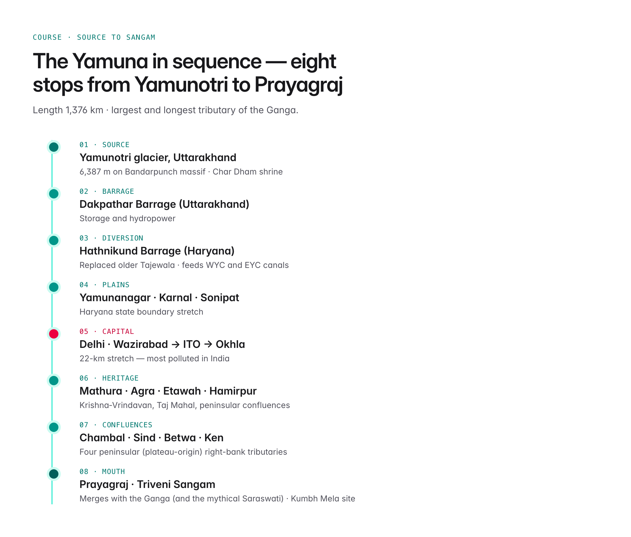
The Yamuna originates from the Yamunotri glacier at an elevation of around 6,387 metres on the Bandarpunch massif in Uttarkashi district, Uttarakhand. The first few kilometres are characterised by steep descent, glacial meltwater, and narrow gorges.

Oxford Student Atlas for India — 7th Edition
- 160 pages, Oxford University Press, the current edition
- India-focused thematic maps: physical, political, rivers, climate, soils, vegetation, plus world maps
- Made for UPSC and state PSC map work; slim enough to stay open beside the textbook
Key upper-course markers on the Yamuna river map:
- Yamunotri shrine — one of the four Char Dham pilgrimage sites
- Har Ki Dun valley — a side valley feeding tributaries
- The river enters the plains near Tajewala (Haryana), where the first major barrage is located
- The Dakpathar barrage in Uttarakhand is an important storage and hydropower project
Middle Course: Plains Stretch
After leaving the hills, the Yamuna flows roughly southward through the plains of Haryana, Delhi and Uttar Pradesh. Key features in this stretch:
- The Hathnikund Barrage (Haryana, replacing the older Tajewala) diverts water to the Western Yamuna Canal (WYC) and Eastern Yamuna Canal (EYC)
- Wazirabad Barrage supplies drinking water to Delhi
- ITO and Okhla barrages regulate flow within and downstream of the capital
- The river marks significant state boundaries between Haryana and Uttar Pradesh, and later between Uttar Pradesh and Madhya Pradesh
- Major cities along the banks include Yamunanagar, Karnal, Delhi, Mathura, Agra, Etawah, Hamirpur and Prayagraj
Tributaries
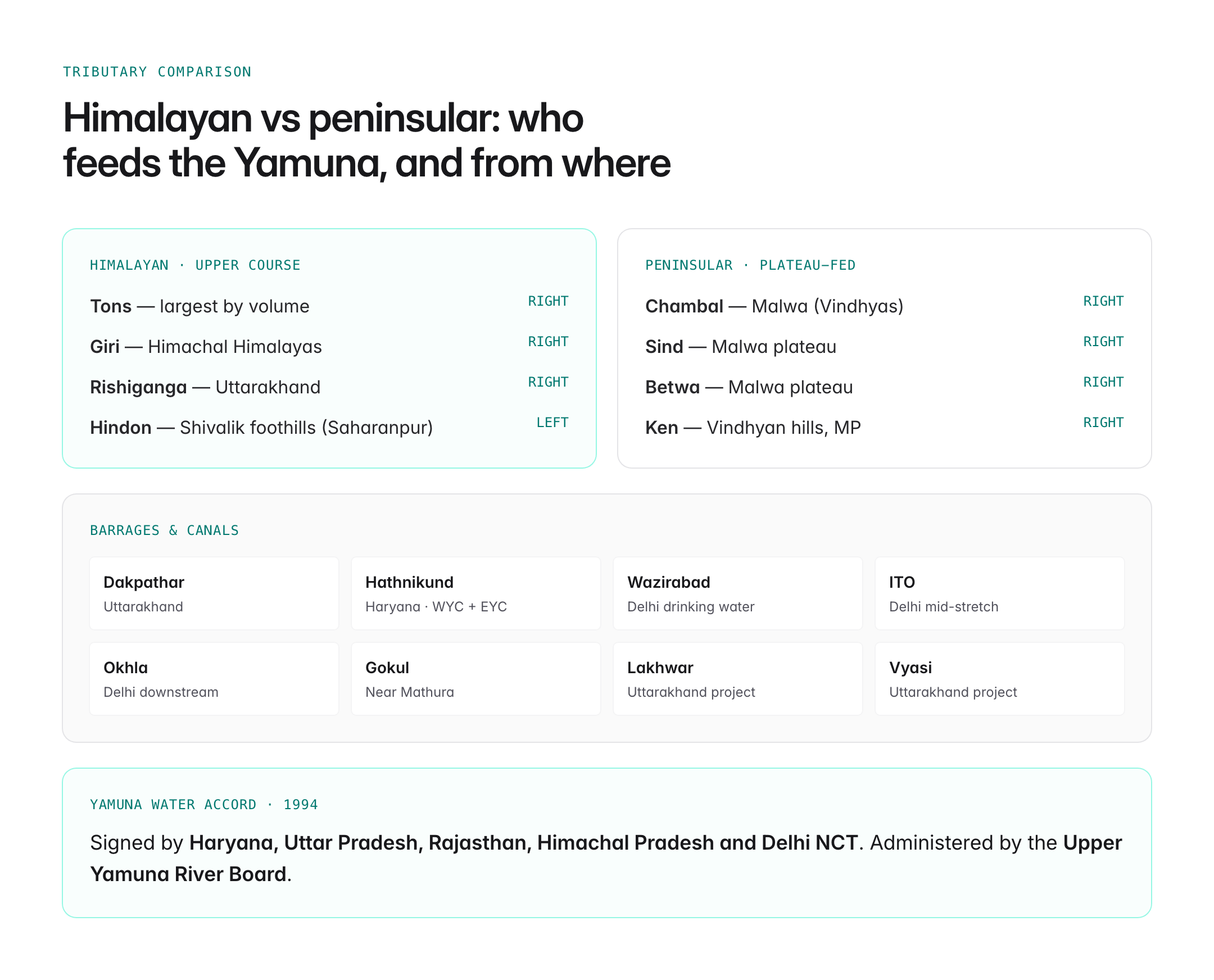
The Yamuna receives water from both Himalayan and peninsular tributaries. This mixed catchment is a frequent UPSC question.
| Tributary | Bank | Source region |
|---|---|---|
| Tons | Right | Himalaya — largest tributary by volume |
| Giri | Right | Himachal Himalayas |
| Rishiganga | Right | Uttarakhand |
| Hindon | Left | Shivalik foothills near Saharanpur |
| Chambal | Right | Malwa plateau (Vindhyas) |
| Sind | Right | Malwa |
| Betwa | Right | Malwa |
| Ken | Right | Vindhyan hills, Madhya Pradesh |
The Chambal, Sind, Betwa and Ken are all peninsular (plateau-origin) rivers joining the Yamuna from the right — a fact often asked in prelims.
Major Barrages and Canals
The Yamuna is one of India's most engineered rivers. Key works include:
- Dakpathar Barrage (Uttarakhand)
- Hathnikund Barrage (Haryana) — feeds WYC and EYC
- Wazirabad Barrage (Delhi)
- ITO Barrage and Okhla Barrage (Delhi)
- Gokul Barrage (near Mathura)
- Lakhwar and Vyasi projects (Uttarakhand)
Water sharing among the co-basin states is governed by the Yamuna Water Accord of 1994, signed by Haryana, Uttar Pradesh, Rajasthan, Himachal Pradesh and the National Capital Territory of Delhi, and administered by the Upper Yamuna River Board.
Cities and Civilisational Significance
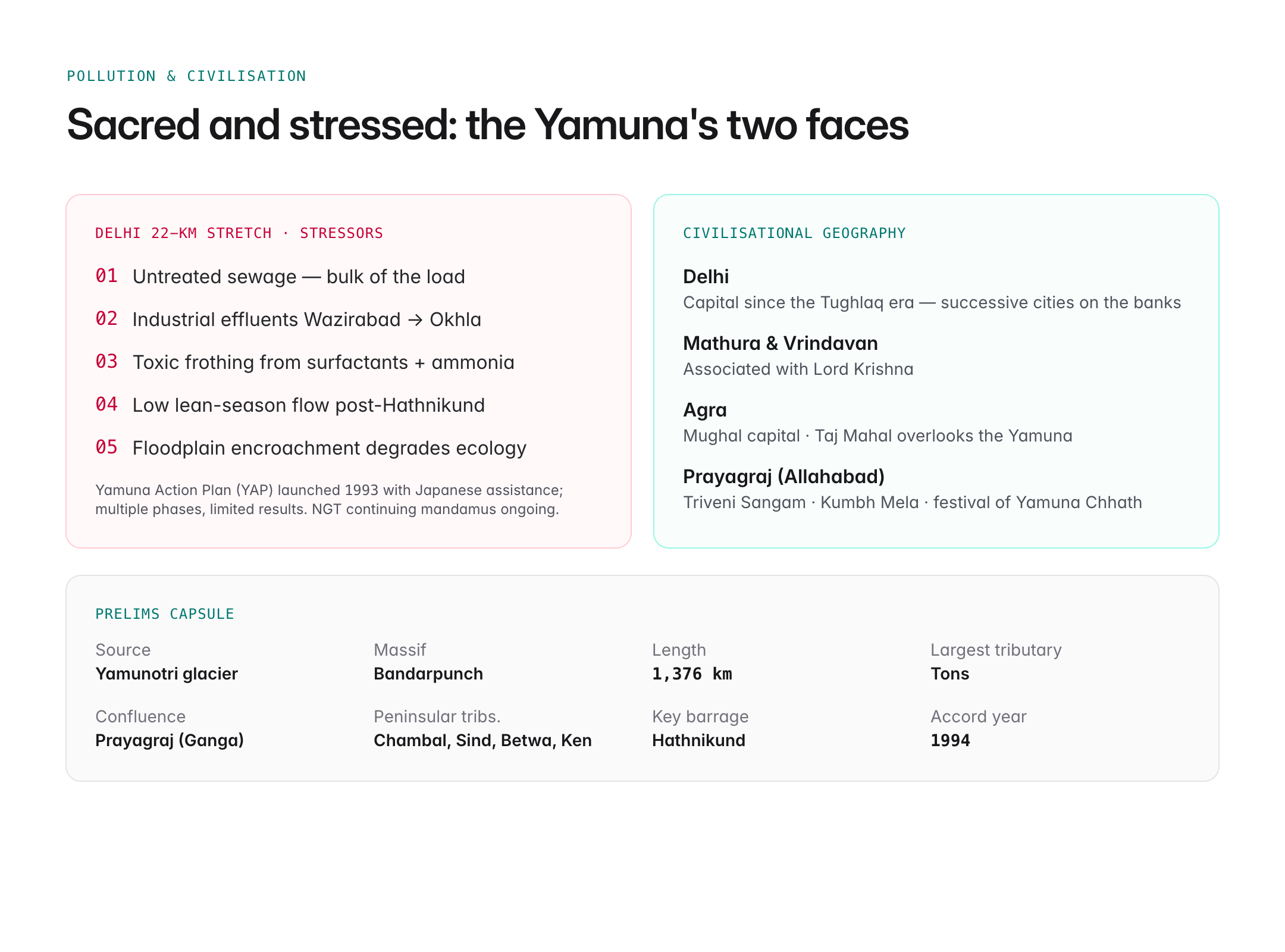
The Yamuna has shaped north Indian civilisation. Its banks host some of the most historically significant cities of India:
- Delhi — capital since the Tughlaq period and before, with successive cities built along the Yamuna
- Mathura and Vrindavan — associated with the life of Lord Krishna
- Agra — the Mughal capital with the Taj Mahal on its banks
- Prayagraj (Allahabad) — site of the Triveni Sangam with the Ganga and the mythical Saraswati, and venue for the Kumbh Mela
The river is sacred in Hindu tradition; the festival of Yamuna Chhath and rituals at the sangam are central religious observances.
Pollution and Environmental Issues
The Yamuna, especially the 22-kilometre stretch through Delhi, is among the most polluted rivers in India. Key concerns:
- Untreated sewage from Delhi accounts for a large share of pollution load
- Industrial effluents from Wazirabad to Okhla
- Frothing due to surfactants and ammonia levels
- Reduced lean-season flow after Hathnikund diversions
- Encroachment on floodplains affecting drainage and ecology
The Yamuna Action Plan (YAP), launched in 1993 with Japanese assistance, has passed through multiple phases but has had limited success. The National Green Tribunal's continuing mandamus on Yamuna cleaning is an ongoing governance case.
Yamuna River Map: Key Locations in Sequence
If you had to trace the Yamuna on a map from source to mouth, you would pass in order:
- Yamunotri glacier (source)
- Dakpathar Barrage (Uttarakhand)
- Hathnikund Barrage (Haryana)
- Yamunanagar, Karnal, Sonipat (Haryana)
- Delhi (Wazirabad → ITO → Okhla barrages)
- Mathura, Agra, Etawah, Kanpur Dehat, Hamirpur
- Confluence with Chambal, Sind, Betwa and Ken
- Prayagraj (Triveni Sangam) — merger with the Ganga
UPSC Relevance
Prelims focus: Know that the Yamuna rises from Yamunotri glacier on Bandarpunch, its largest tributary is the Tons, major right-bank peninsular tributaries are Chambal, Sind, Betwa and Ken, and it merges with the Ganga at Prayagraj. Remember Hathnikund, WYC, EYC, and the Yamuna Water Accord of 1994.
Mains GS-I and GS-III angle: Use the Yamuna in questions on Indian drainage systems, interstate water disputes, river pollution, urban water supply, and cultural geography of northern India. It is a classic case study for river rejuvenation governance.
Sample PYQ angle: UPSC has asked about the peninsular tributaries of the Ganga, interstate water-sharing accords, and pollution of the Yamuna. A map-based question asking to identify cities or tributaries along the river is a common prelims pattern.