Himalayan Geography: Ranges, Passes & UPSC Notes
Complete guide to Himalayan geography — ranges, passes, glaciers, longitudinal divisions, and key features. Essential for UPSC Geography preparation.
Himalayan Geography: Ranges, Passes & UPSC Notes
The Himalayas are the youngest and highest mountain system on Earth, stretching approximately 2,400 km from the Indus gorge in the west to the Brahmaputra gorge in the east. Formed by the collision of the Indian and Eurasian tectonic plates about 50 million years ago, they continue to rise at approximately 1 cm per year. For UPSC, Himalayan geography is a foundational topic — covering physical features, passes, glaciers, river origins, and the mountain’s influence on India’s climate, drainage, and biodiversity.
Formation of the Himalayas
The Himalayas formed through the convergent collision of the Indo-Australian Plate with the Eurasian Plate during the Cenozoic era. The Tethys Sea — an ancient ocean between the two plates — was compressed and uplifted as the Indian plate pushed northward.
Key Events in Formation
| Period | Event |
|---|---|
| ~225 Ma (Triassic) | Pangaea begins breaking apart |
| ~140 Ma (Cretaceous) | India separates from Gondwanaland; Tethys Sea exists between India and Eurasia |
| ~50 Ma (Eocene) | Indian Plate collides with Eurasian Plate; initial uplift begins |
| ~30 Ma (Oligocene) | Major uplift phase; Great Himalayas begin forming |
| ~15 Ma (Miocene) | Lesser Himalayas and Siwaliks form from eroded sediments |
| Present | Himalayas continue rising ~1 cm/year; seismically active |
The presence of marine fossils (including ammonites) in Himalayan rocks — particularly in the Spiti Valley and Ladakh — confirms the oceanic origin of these sediments. The Tethys Himalaya preserves these ancient sea-floor deposits.
Longitudinal Divisions (North to South)
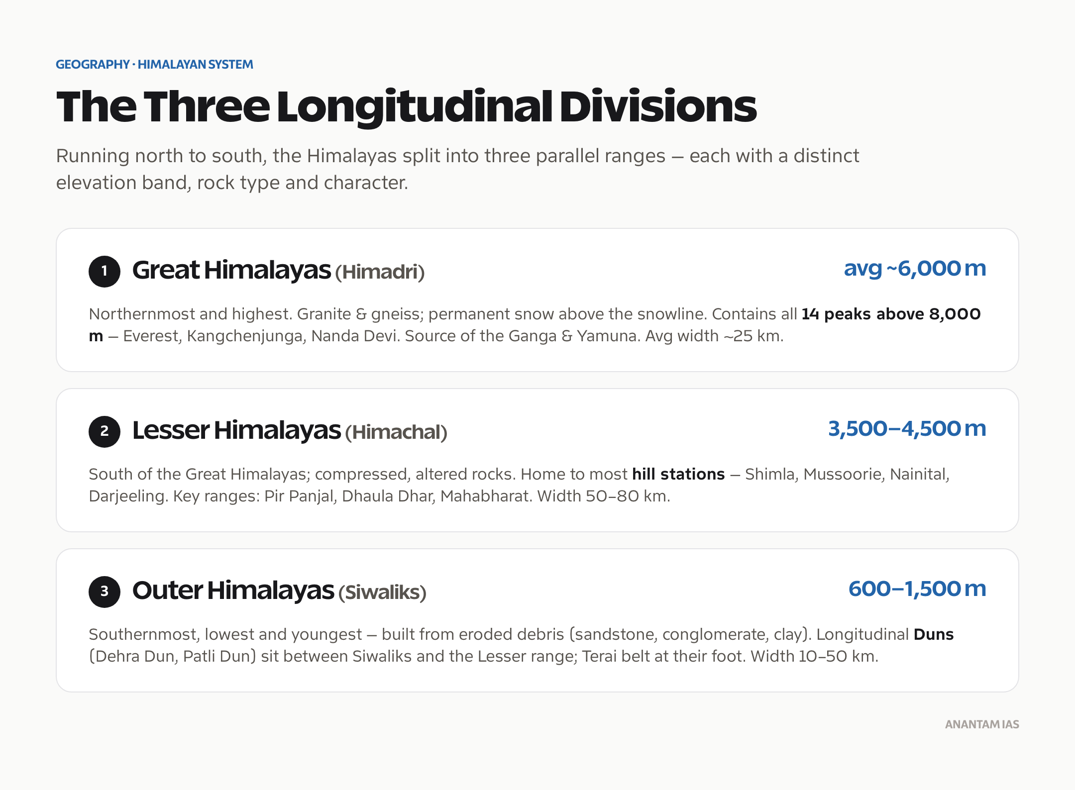
The Himalayas are divided into three parallel ranges running from northwest to southeast, each with distinct geological and physical characteristics.
1. Great Himalayas (Himadri)
The northernmost and highest range, with an average elevation of 6,000 metres. It contains all peaks above 8,000 metres and is composed primarily of granite and gneiss.
Key features:
- Average width: 25 km
- Contains 14 peaks above 8,000 m (including Mount Everest at 8,849 m)
- Permanent snow cover and glaciers above the snowline (~4,500 m)
- Major peaks: Everest, Kangchenjunga, Nanga Parbat, Nanda Devi, Kamet, Annapurna
- Source of major rivers — Ganga (Gangotri), Yamuna (Yamunotri)
2. Lesser Himalayas (Himachal)
Located south of the Great Himalayas, with elevations ranging from 3,500 to 4,500 metres. This range is composed of highly compressed and altered rocks.
Key features:
- Average width: 50-80 km
- Contains most hill stations: Shimla, Mussoorie, Nainital, Darjeeling, Manali
- Important ranges: Pir Panjal (longest in Lesser Himalayas), Dhaula Dhar, Mahabharat Range
- Valleys: Kashmir Valley (between Pir Panjal and Great Himalayas), Kangra Valley, Kullu Valley
- The Pir Panjal Range separates the Kashmir Valley from the Jammu plains
3. Outer Himalayas (Siwaliks/Shivaliks)
The southernmost and lowest range, with elevations between 600 and 1,500 metres. Composed of unconsolidated river deposits — sandstone, conglomerate, and clay.
Key features:
- Average width: 10-50 km
- Youngest Himalayan range (formed from debris eroded from rising Himalayas)
- Duns/Doons: Longitudinal valleys between Siwaliks and Lesser Himalayas (e.g., Dehra Dun, Patli Dun, Kotli Dun)
- Terai: Marshy, forested belt at the foot of the Siwaliks
- Prone to landslides due to loose sedimentary composition
Comparison of Himalayan Ranges
| Feature | Great Himalayas | Lesser Himalayas | Siwaliks |
|---|---|---|---|
| Average Elevation | 6,000 m | 3,500-4,500 m | 600-1,500 m |
| Width | ~25 km | 50-80 km | 10-50 km |
| Rock Type | Granite, gneiss | Metamorphic, sedimentary | Unconsolidated sediments |
| Snow Cover | Permanent above snowline | Seasonal | Rare |
| Economic Significance | Glaciers, water source | Hill stations, tourism, orchards | Forests, agriculture |
| Seismicity | High | Moderate-High | High (loose formations) |
Regional Divisions (West to East)
The Himalayas are also divided regionally:
Western Himalayas
| Sub-region | Location | Key Features |
|---|---|---|
| Kashmir Himalayas | J&K, Ladakh | Zanskar Range, Karakoram, Nubra Valley, Zoji La, Dal Lake |
| Himachal Himalayas | Himachal Pradesh | Kullu Valley, Rohtang Pass, Spiti Valley, Dhaula Dhar |
| Kumaon Himalayas | Uttarakhand | Nanda Devi, Badrinath, Valley of Flowers, Gangotri |
Central Himalayas (Nepal Himalayas)
Contains the highest peaks — Everest (8,849 m), Kangchenjunga (8,586 m), Lhotse, Makalu, Dhaulagiri, and Annapurna. This section includes Nepal and the Indo-Nepal border region.
Eastern Himalayas
| Sub-region | Location | Key Features |
|---|---|---|
| Sikkim Himalayas | Sikkim | Kangchenjunga; Nathu La and Jelep La passes |
| Assam/Arunachal Himalayas | Arunachal Pradesh | Namcha Barwa; Brahmaputra gorge; Bomdila, Tawang |
| Purvanchal (Eastern Hills) | NE India (beyond Dihang gorge) | Patkai, Naga, Lushai, Mizo Hills; run north-south |
The Purvanchal hills — running north-south — are considered an extension of the Himalayan system. They include the Patkai Bum, Naga Hills, Manipur Hills, Mizo Hills (Lushai Hills), and Tripura Hills.
Important Himalayan Passes
Passes are critical for trade, military movement, and cultural exchange. They appear frequently in UPSC Prelims.
Key Passes
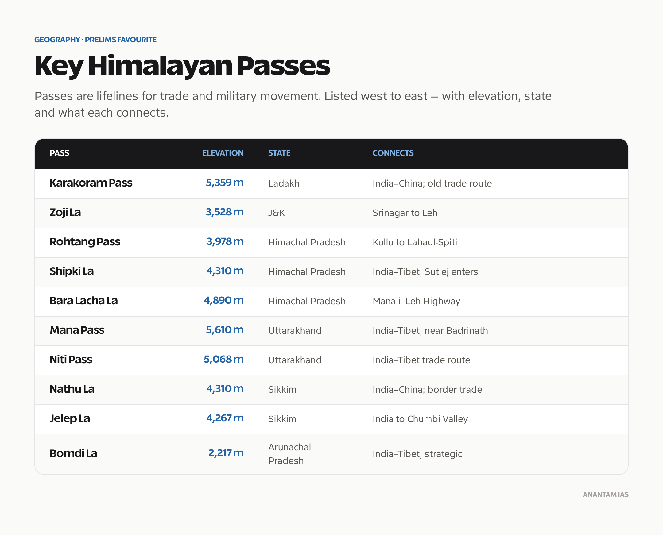
| Pass | Elevation | State | Connects |
|---|---|---|---|
| Karakoram Pass | 5,359 m | Ladakh | India-China (highest pass on old trade route) |
| Khunjerab Pass | 4,693 m | PoK | Pakistan-China (Karakoram Highway) |
| Zoji La | 3,528 m | J&K | Srinagar to Leh; connects Kashmir Valley to Ladakh |
| Rohtang Pass | 3,978 m | Himachal Pradesh | Kullu to Lahaul-Spiti |
| Shipki La | 4,310 m | Himachal Pradesh | India-Tibet border; Sutlej enters India here |
| Bara Lacha La | 4,890 m | Himachal Pradesh | Manali-Leh Highway |
| Mana Pass | 5,610 m | Uttarakhand | India-Tibet border; near Badrinath |
| Niti Pass | 5,068 m | Uttarakhand | India-Tibet trade route |
| Nathu La | 4,310 m | Sikkim | India-China; reopened for border trade in 2006 |
| Jelep La | 4,267 m | Sikkim | India to Chumbi Valley (Tibet) |
| Bomdi La | 2,217 m | Arunachal Pradesh | India-Tibet; strategically significant |
| Lipu Lekh | 5,334 m | Uttarakhand | India-Tibet-Nepal tri-junction area |
| Diphu Pass | ~4,587 m | Arunachal Pradesh | India-China-Myanmar tri-junction area |
UPSC Mnemonic for Passes (West to East)
Karakoram → Zoji La → Rohtang → Shipki La → Bara Lacha La → Mana → Niti → Nathu La → Jelep La → Bomdi La
Glaciers of the Himalayas
Himalayan glaciers are the largest ice mass outside the polar regions — often called the Third Pole. They feed India’s perennial rivers and are critical to water security for over a billion people.
Major Glaciers
| Glacier | Length (km) | River Fed | Location |
|---|---|---|---|
| Siachen | 76 km | Nubra (→ Shyok → Indus) | Karakoram Range, Ladakh |
| Gangotri | 30 km | Bhagirathi (→ Ganga) | Uttarakhand |
| Zemu | 26 km | Teesta | Sikkim |
| Milam | 16 km | Goriganga (→ Kali) | Uttarakhand |
| Biafo | 67 km | Braldu (→ Shigar → Indus) | Karakoram |
| Pindari | 3 km | Pindar (→ Alaknanda) | Uttarakhand |
Glacier Retreat and Climate Change
Himalayan glaciers are retreating at an alarming rate. The ISCCC (Indian Space Research Organisation) estimated that over 85% of Himalayan glaciers showed retreat between 2000 and 2020. This has implications for:
- Reduced dry-season river flow in the long term
- Increased glacial lake outburst floods (GLOFs) in the short term
- Threat to hydropower infrastructure
- Impact on agriculture dependent on glacial meltwater
Trans-Himalayan Ranges
Located north of the Great Himalayas, the Trans-Himalayan ranges include:
| Range | Key Feature |
|---|---|
| Karakoram | Contains K2 (8,611 m); Siachen Glacier; India’s northernmost range |
| Ladakh Range | Between Indus and Shyok rivers; arid cold desert |
| Zaskar Range | Between Indus and Zaskar rivers; Zanskar Valley |
| Kailash Range | Contains Mount Kailash (6,638 m); sacred in Hinduism and Buddhism |
The Trans-Himalayas are drier, colder, and more barren than the main Himalayan ranges because they lie in the rain shadow.
Himalayas and Indian Climate
The Himalayas profoundly influence India’s climate:
- Monsoon Barrier — force moisture-laden southwest monsoon winds to rise, causing orographic rainfall on the Indian side
- Cold Wave Shield — block bitter cold winds from Central Asia, keeping the Indo-Gangetic Plain warmer than equivalent latitudes elsewhere
- Biodiversity Gradient — altitudinal zones support tropical to alpine vegetation within short horizontal distances
- River Systems — snowmelt and glacial melt feed India’s perennial river systems
Peninsular Plateau of India: Features & Resources River Systems of India: Himalayan & Peninsular
Frequently Asked Questions
How were the Himalayas formed?
The Himalayas formed approximately 50 million years ago when the Indian Plate collided with the Eurasian Plate. The Tethys Sea between the two plates was compressed, and its sediments were uplifted to form the mountain ranges. The collision continues today, causing the Himalayas to rise about 1 cm per year and making the region seismically active.
What are the three parallel ranges of the Himalayas?
The three ranges from north to south are: Great Himalayas (Himadri) — highest at 6,000 m average with permanent snow; Lesser Himalayas (Himachal) — 3,500-4,500 m with hill stations; and Siwaliks (Outer Himalayas) — 600-1,500 m, the youngest range composed of loose river sediments prone to landslides.
Which is the highest peak in India?
Kangchenjunga at 8,586 metres (28,169 feet) is India’s highest peak, located on the Sikkim-Nepal border. It’s the third-highest mountain in the world. K2 (8,611 m) — the world’s second-highest — is technically in Pakistan-administered territory. Nanda Devi (7,816 m) is the highest peak entirely within Indian territory.
What are Duns in the Himalayan context?
Duns (or Doons) are longitudinal valleys formed between the Siwaliks and the Lesser Himalayas. They’re created by tectonic activity and filled with coarse alluvium deposited by Himalayan rivers. Dehra Dun is the most famous example. Others include Patli Dun, Kotli Dun, and Udhampur Dun. They have fertile soil and support agriculture.
Why is the Siachen Glacier strategically important?
The Siachen Glacier — the world’s highest battlefield at over 6,000 m — lies in the Karakoram Range near the India-Pakistan-China tri-junction. India has maintained military presence since 1984 (Operation Meghdoot) to prevent Pakistani control of the glacier, which would give Pakistan strategic access to the Karakoram Pass and proximity to the China border.