

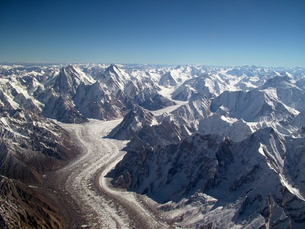
The Karakoram Range is the great west-of-Himalaya mountain wall that runs along the northern frontier of India and forms the highest concentration of glaciated peaks outside the polar regions. Stretching roughly 500 kilometres from the Pamir knot in the west to the Aghil Range and the upper Shyok in the east, the Karakoram Range is part of the Trans-Himalayan system but is geologically and tectonically distinct from the main Himalayan chain to its south. Four of the world’s 14 peaks above 8,000 metres rise from the Karakoram Range, including K2, the second-highest mountain on Earth. The range contains the largest non-polar glaciers, the most rugged high-altitude terrain in Asia, and a Line of Actual Control that has shaped Indian strategy since 1947. The Karakoram Range remains one of the most strategically sensitive and physiographically extreme regions on the Indian map.
Position in the Indian Mountain System
The Karakoram Range lies entirely north of the Indus river and forms the northernmost mountain wall of the Indian territory of Ladakh. To its south, separated by the Shyok and Nubra valleys, lies the Ladakh Range. To the east, it merges into the Aghil Range and the Kunlun shield of the Tibetan Plateau. To the west, beyond the Hunza valley, it joins the Pamir knot.
The Karakoram Range is part of the larger Trans-Himalayan system, which also includes the Zaskar, Ladakh, and Kailash ranges. The Trans-Himalayan ranges were uplifted earlier than the main Himalaya and are made up largely of igneous and metamorphic rocks rather than the sedimentary sequences typical of the Greater Himalaya.
Tectonic Origin
The Karakoram Range was uplifted by the collision of the Indian and Eurasian plates that began about 50 million years ago and continues today. The range is rising at roughly 4 to 5 millimetres per year, one of the fastest rates of orogenic uplift anywhere on Earth. The active fault that defines the southern boundary of the range is the Karakoram Fault, a major right-lateral strike-slip fault that extends for over 1,000 kilometres from the Pamirs into Tibet.
K2: The Second-Highest Peak on Earth
K2 (8,611 metres) is the crown of the Karakoram Range and the second-highest mountain in the world after Mount Everest. It was first surveyed by Thomas Montgomerie of the Great Trigonometrical Survey in 1856, who assigned it the code K2, the second peak of the Karakoram. The peak straddles the China–Pakistan border at the head of the Baltoro Glacier and lies in the part of Pakistan-occupied Kashmir that India claims as part of its territory.
K2 is technically more difficult than Everest. Its summit-attempt fatality rate is roughly 25 per cent, the highest of any 8,000-metre peak. It was first climbed in 1954 by an Italian expedition led by Ardito Desio.
Other 8,000-Metre Peaks
The Karakoram Range contains three more peaks above 8,000 metres: Gasherbrum I (8,080 m), Broad Peak (8,051 m), and Gasherbrum II (8,035 m). All four eight-thousanders cluster around the upper Baltoro Glacier in a single concentrated region. Other major peaks include Gasherbrum III, IV, and V, the Masherbrum, Saltoro Kangri, Saser Kangri (in Indian territory), Mamostong Kangri, and Rimo I.
Sub-Ranges of the Karakoram
The Karakoram Range is conventionally divided into several sub-ranges. The Saltoro Range lies west of the Siachen Glacier and includes the Saltoro Kangri (7,742 m) and the Sia Kangri. Indian forces control the Saltoro Ridge, which is the actual ground position rather than the cartographic line. The Gasherbrum Range holds the cluster of eight-thousanders. The Masherbrum Mountains lie south of the Baltoro Glacier. The Hispar Muztagh and Panmah Muztagh lie to the west. The Rimo Muztagh and Saser Muztagh lie in Indian territory east of the Siachen.
The Siachen Glacier
The Siachen Glacier is the largest glacier in the Karakoram Range and the second-longest non-polar glacier in the world, after the Fedchenko in the Pamirs. It measures roughly 76 kilometres in length and covers an area of around 700 square kilometres. The glacier originates at the Indira Col on the Indo-Tibetan border and flows south-east to its snout at the head of the Nubra valley, where it gives birth to the Nubra River, a tributary of the Shyok.
Since April 1984, the Indian Army has controlled the Siachen Glacier and the Saltoro Ridge through Operation Meghdoot, making it the world’s highest battlefield. Indian posts on the Saltoro lie at altitudes between 5,400 and 6,700 metres, where soldiers face temperatures of minus 50 degrees Celsius, avalanches, and severe altitude sickness. The strategic importance of the Siachen lies in its position commanding the watershed between the Shyok valley, the Shaksgam valley (illegally ceded by Pakistan to China in 1963), and the Karakoram Pass.
Other Major Glaciers
The Karakoram Range hosts the largest concentration of glacial ice outside the polar regions. The Biafo–Hispar glacier system extends for 116 kilometres. The Baltoro Glacier (62 km), the Batura Glacier (57 km), and the Chogo Lungma (50 km) are all among the world’s longest. The Karakoram is also remarkable for the so-called “Karakoram anomaly”, which is the observation that glaciers in this range have been stable or even slightly advancing in the recent past, in contrast to the broad pattern of retreat across the rest of the Himalayan system.
Climate and Vegetation
The Karakoram Range lies in the rain shadow of the Greater Himalaya and receives very little monsoon precipitation. Most of its snowfall comes from western disturbances during winter. The high valleys are cold deserts, with annual precipitation often below 100 millimetres. Vegetation is sparse and largely confined to the lower valleys where willow, poplar, and apricot are cultivated through glacier-fed irrigation channels known as kuhls.
The fauna of the Indian Karakoram includes the snow leopard, the Tibetan wild ass, the wild yak, the Ladakhi urial, the bharal (blue sheep), and the brown bear. The Karakoram Wildlife Sanctuary, declared in 1987, covers 5,000 square kilometres along the Shyok–Nubra confluence and is a critical refuge for these species.
Karakoram Pass and Other Passes
The Karakoram Pass (5,540 m) sits on the watershed between the Shyok basin and the Yarkand basin and was the historic route for the trans-Karakoram caravan trade between Ladakh and Yarkand in Chinese Turkestan. The pass lies on the LAC and is currently closed. Khardung La (5,359 m) on the Ladakh Range, although strictly speaking not part of the Karakoram Range, is the principal road link from Leh to the Nubra valley and the Siachen base camp. Saser La (5,411 m) on the Saser Muztagh connects the Nubra valley with the upper Shyok and ultimately the Karakoram Pass.
Strategic Significance
The Karakoram Range is the most strategically sensitive mountain region on the Indian map. The range hosts the Line of Actual Control with China in the Daulat Beg Oldie–Depsang–Galwan sector, the Line of Control with Pakistan along the Saltoro Ridge, and the disputed Shaksgam Valley. The 1962 war with China, the 1984 Siachen operation, and the 2020 Galwan clash all unfolded in or along the southern margin of the Karakoram Range.
The Indian Army maintains its forward-most posts at Daulat Beg Oldie, Indira Col, Bana Post (named for Subedar Bana Singh, the highest-altitude permanently held position in the world at 6,467 metres), and the Sub-Sector North along the Shyok. The Karakoram Range also overlooks the China–Pakistan Economic Corridor and the Karakoram Highway, which runs along the western edge of the range from Kashgar to Islamabad.
Galwan, Depsang, and the LAC
The southern foothills of the Karakoram Range meet the Aksai Chin plateau along the Line of Actual Control. The Galwan valley, where the deadly clash of June 2020 took place, is a glacier-fed tributary of the Shyok that drains the southern slopes of the eastern Karakoram. The Depsang Plains north of Daulat Beg Oldie are an extremely high-altitude pediment (5,200 m) that has been a recurring friction point. The Pangong Tso and the Spanggur Tso, while geomorphologically part of the Ladakh Range rather than the Karakoram, lie within the same strategic theatre.
Indian Territorial Claim
India claims the entire trans-Karakoram tract, including the Shaksgam Valley (5,180 square kilometres, ceded by Pakistan to China in 1963 in violation of Indian sovereignty), the Aksai Chin (38,000 square kilometres, under Chinese control since 1962), and the Gilgit–Baltistan region (which contains K2 and most of the western Karakoram).
Frequently Asked Questions
Where is the Karakoram Range located?
The Karakoram Range runs along the northern frontier of India through Ladakh, with extensions into Pakistan-occupied Kashmir, the Gilgit–Baltistan region, the Xinjiang province of China, and a small portion of Afghanistan. In Indian territory, it lies entirely north of the Indus river.
Why is K2 considered harder to climb than Everest?
K2, the highest peak of the Karakoram Range at 8,611 metres, has a summit-attempt fatality rate of around 25 per cent, far higher than Everest. The peak is steeper, more technically demanding, more exposed to storms, and has no easy route to the summit.
What is the Siachen Glacier and why is it strategically important?
The Siachen Glacier is the largest glacier in the Karakoram Range and the second-longest non-polar glacier in the world. India has controlled it since Operation Meghdoot in 1984. It commands the watershed between the Shyok, Shaksgam, and Yarkand basins and overlooks the Karakoram Pass.
What is the Saltoro Ridge?
The Saltoro Ridge is a sub-range of the Karakoram Range west of the Siachen Glacier. Indian forces control the ridge, which forms the actual ground position between India and Pakistan in this sector. The Bana Post on the Saltoro is the highest permanently held military position in the world.
What is the Karakoram anomaly?
The Karakoram anomaly is the observation that glaciers in the Karakoram Range have been stable or slightly advancing in recent decades, in contrast to the general pattern of glacier retreat across the rest of the Himalayan system. Scientists attribute this to a combination of higher winter snowfall and cooler summers.
How does the Karakoram Range differ from the main [Himalayas](/satpura-mountain-range/)?
The Karakoram Range is part of the Trans-Himalayan system, separated from the Greater Himalaya by the Indus valley. Compared to the Vindhya or Satpura block mountains of peninsular India, the Karakoram is a young, active fold-and-thrust range with the highest concentration of 8,000-metre peaks anywhere outside Nepal.
Which Indian states or union territories cover the Karakoram?
In Indian territory, the Karakoram Range lies entirely within the union territory of Ladakh. India also claims the parts of the range that fall in Gilgit–Baltistan (under Pakistani administration) and the Shaksgam Valley (under Chinese administration).
What is the Karakoram Pass?
The Karakoram Pass at 5,540 metres sits on the watershed between the Shyok basin in India and the Yarkand basin in Xinjiang. It was the historic route for the trans-Karakoram caravan trade between Leh and Yarkand. The pass is now closed and lies on the Line of Actual Control.
Tell Google you want more of this.
Add Anantam IAS as a preferred sourceOne tap, and this site shows up more often in your own Top Stories, AI Overviews and AI Mode. Remove it any time.






