Hindon River — Yamuna’s Most Polluted Tributary & UPSC Geography Guide
Complete UPSC guide to Hindon River — origin, course through Uttar Pradesh, pollution crisis, revival project, CPCB classification, and environmental significance.
The Hindon River (also spelled Hyndon or locally called Hindon Nadi) is a tributary of the Yamuna River that flows through western Uttar Pradesh. Once a lifeline for agriculture and drinking water in the upper Doab region, the Hindon has become one of India's most polluted rivers, with stretches classified as unfit for any use by the Central Pollution Control Board (CPCB).
For UPSC, the Hindon River is relevant to Geography (GS Paper I) for river systems and to Environment (GS Paper III) for water pollution, river rejuvenation, and the broader Yamuna ecosystem.
Origin and Course
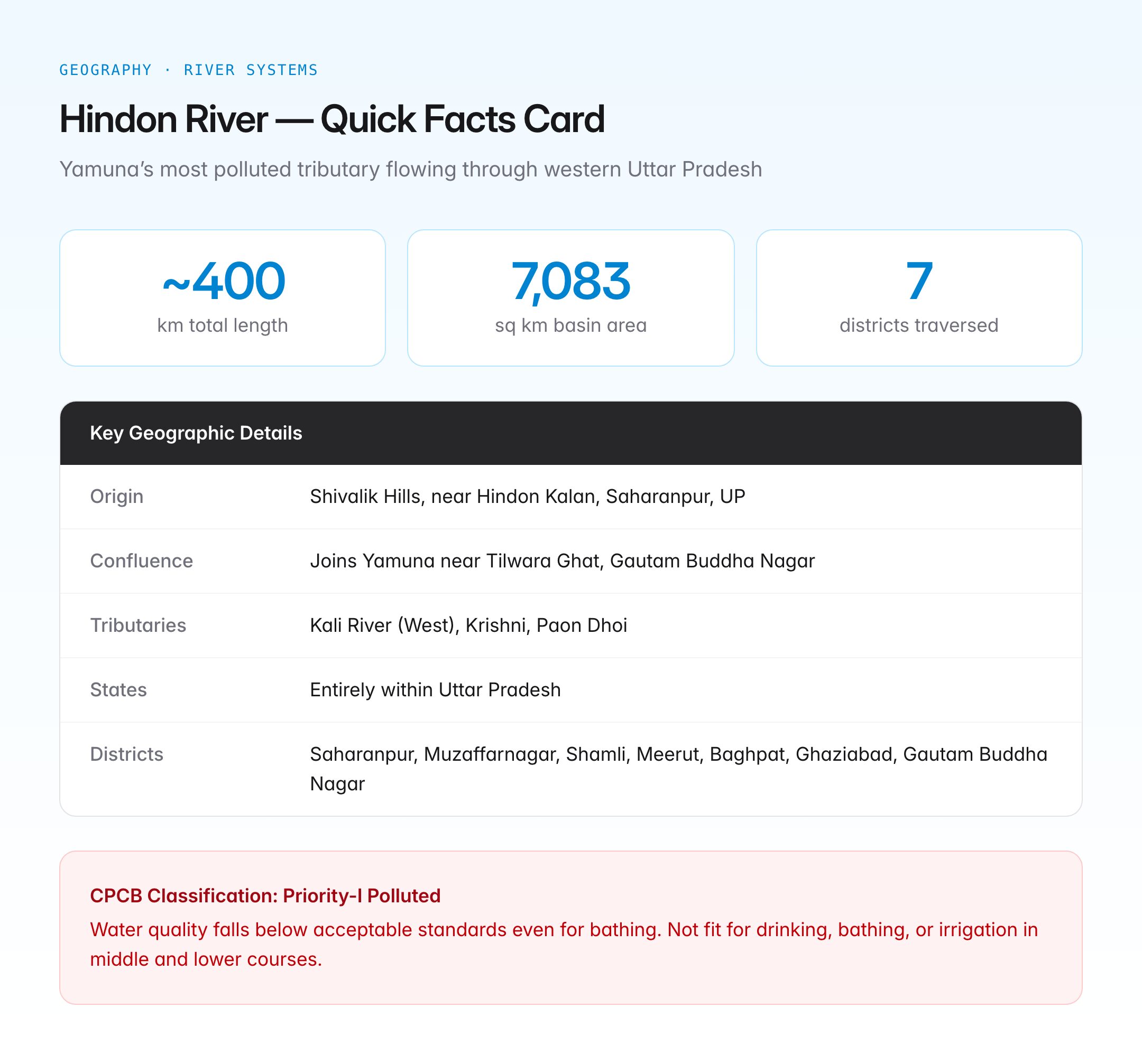
The Hindon River originates in the Shivalik Hills (lower Himalayas) near the village of Hindon Kalan in Saharanpur district, Uttar Pradesh. It flows in a broadly south-southeast direction through the fertile Upper Ganga-Yamuna Doab before joining the Yamuna River near Tilwara Ghat in Gautam Buddha Nagar district, close to Noida.
Key Geographic Details
| Feature | Detail |
|---|---|
| Origin | Shivalik Hills, near Hindon Kalan, Saharanpur district, UP |
| Total length | Approximately 400 km |
| Confluence | Joins Yamuna River near Tilwara Ghat, Gautam Buddha Nagar |
| Basin area | Approximately 7,083 sq km |
| Major tributaries | Kali River (West), Krishni, Paon Dhoi |
| States traversed | Uttar Pradesh (entirely within UP) |
| Districts traversed | Saharanpur, Muzaffarnagar, Shamli, Meerut, Baghpat, Ghaziabad, Gautam Buddha Nagar |
Course Through Uttar Pradesh
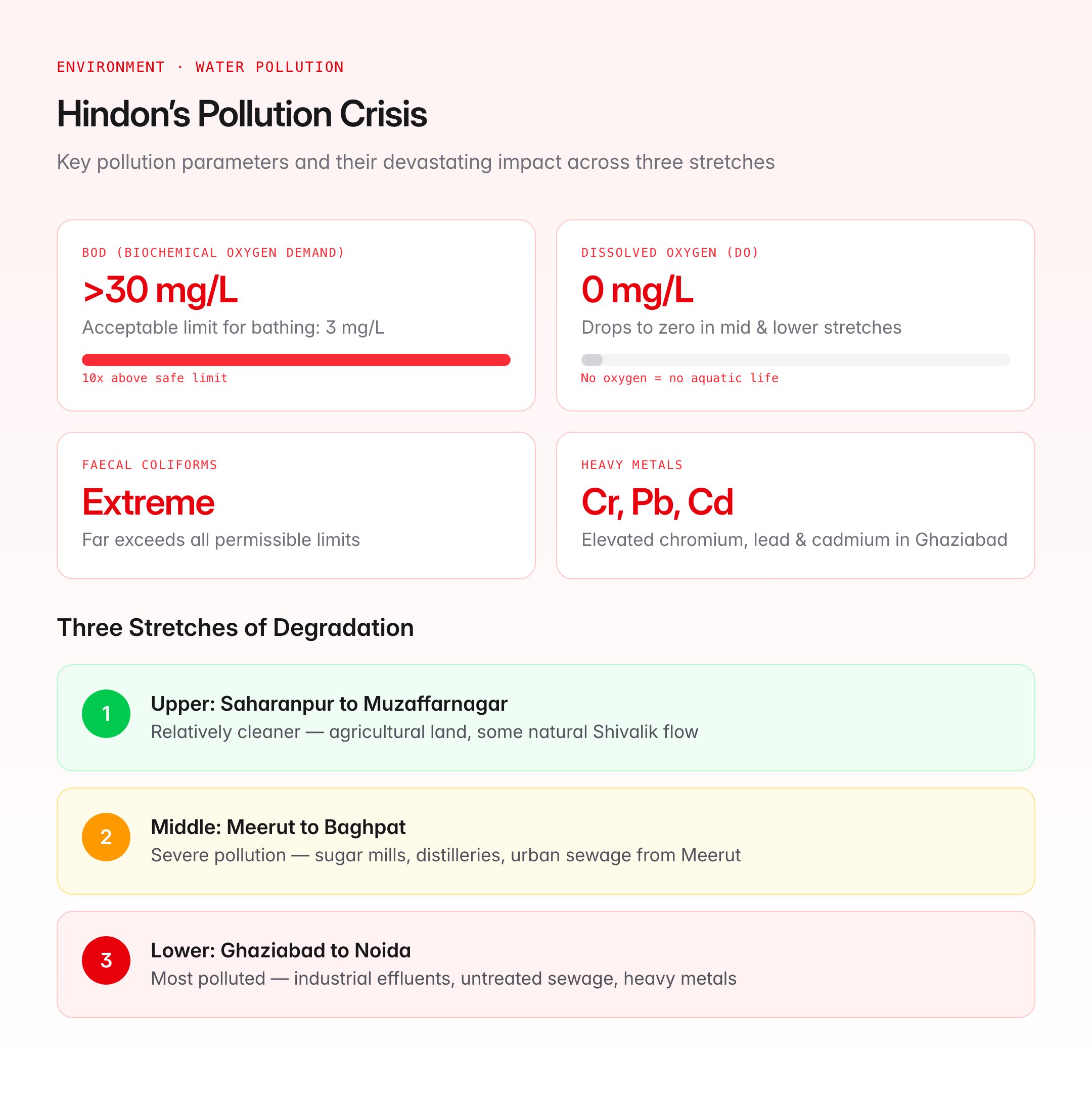
The Hindon's journey can be divided into three distinct stretches:
- Upper stretch (Saharanpur to Muzaffarnagar) — relatively cleaner, flowing through agricultural land with some natural flow from the Shivaliks
- Middle stretch (Meerut to Baghpat) — severe pollution from sugar mills, distilleries, and urban sewage of Meerut city
- Lower stretch (Ghaziabad to Noida) — the most polluted section, receiving industrial effluents and untreated sewage from Ghaziabad and surrounding urban areas
The Pollution Crisis
The Hindon River is widely regarded as one of the most polluted rivers in India. Multiple assessments by the CPCB and the National Green Tribunal (NGT) have highlighted the severity of contamination.
Sources of Pollution
| Source | Contribution |
|---|---|
| Industrial effluent | Sugar mills, distilleries, paper mills, chemical plants, dyeing units along the corridor |
| Domestic sewage | Untreated sewage from Saharanpur, Muzaffarnagar, Meerut, Ghaziabad, and smaller towns |
| Agricultural runoff | Pesticides, fertilisers, and irrigation return flows from the intensively farmed Doab |
| Solid waste | Direct dumping of garbage and debris into the river and on its floodplain |
| Encroachment | Construction on the riverbed and floodplain, reducing natural flow and self-purification capacity |
CPCB Classification
The CPCB has classified long stretches of the Hindon as "Priority-I" polluted river stretches, meaning the water quality falls below the acceptable standards even for bathing (Class-B). Key parameters that exceed limits include:
- Biochemical Oxygen Demand (BOD) — frequently above 30 mg/L (acceptable limit: 3 mg/L for Class-B)
- Dissolved Oxygen (DO) — often drops to zero in parts of the middle and lower stretches
- Faecal coliforms — levels far exceed permissible limits
- Heavy metals — elevated concentrations of chromium, lead, and cadmium in the Ghaziabad stretch
The CPCB's monitoring data consistently shows that the Hindon is not fit for drinking, bathing, or even irrigation in its middle and lower courses.
Health and Environmental Impact
- Groundwater contamination — polluted river water seeps into aquifers, affecting drinking water wells in surrounding villages
- Aquatic life — virtually no fish or aquatic biodiversity survives in the middle and lower stretches
- Agriculture — farmers using Hindon water for irrigation report crop damage and soil degradation
- Public health — communities along the river report elevated incidences of skin diseases, gastrointestinal disorders, and waterborne infections
Hindon Revival and Rejuvenation Efforts
National Green Tribunal (NGT) Interventions
The NGT has taken suo motu cognisance of the Hindon's pollution crisis multiple times. Key directives have included:
- Orders to identify and shut down polluting industries operating without effluent treatment plants (ETPs)
- Directions to municipalities along the river to ensure sewage treatment before discharge
- Constitution of monitoring committees with representation from CPCB, state PCB, and district administration
- Prohibition on direct discharge of untreated effluent into the river
Hindon Rejuvenation Plan
The Uttar Pradesh government has announced a Hindon Rejuvenation Plan with the following components:
- Sewage Treatment Plants (STPs) — construction and upgradation of STPs in Saharanpur, Muzaffarnagar, Meerut, Ghaziabad, and other urban centres
- Industrial effluent control — enforcement of Zero Liquid Discharge (ZLD) norms for major polluting industries
- River floodplain restoration — removal of encroachments and creation of buffer zones along the riverbank
- Eco-flow maintenance — ensuring a minimum environmental flow in the river channel
- Community participation — involvement of local panchayats and NGOs in monitoring and maintenance
Connection to Namami Gange
Since the Hindon ultimately feeds into the Yamuna, which in turn joins the Ganga, the pollution of the Hindon contributes to the larger Ganga basin pollution. The Namami Gange programme has identified tributaries like the Hindon as critical intervention points, recognising that cleaning the Ganga requires addressing pollution in its tributary network.
Hindon River and the Saraswati Debate
The Hindon River is sometimes mentioned in the context of the Saraswati River debate. Some researchers have proposed that the ancient Saraswati may have had tributaries in the Shivalik region that overlapped with the present-day Hindon-Kali river system. However, this remains a contested hypothesis, and the mainstream geological view links the ancient Saraswati more closely to the Ghaggar-Hakra system further west.
Comparison with Other Polluted Tributaries
| River | Parent River | Key Pollution Zone | Status |
|---|---|---|---|
| Hindon | Yamuna | Meerut-Ghaziabad stretch | Priority-I polluted |
| Kali (East) | Ganga | Meerut-Bulandshahr | Priority-I polluted |
| Assi | Ganga | Varanasi | Severely polluted |
| Musi | Krishna | Hyderabad | Polluted but under restoration |
UPSC Relevance
GS Paper Mapping
| Paper | Topic | Connection |
|---|---|---|
| GS Paper I | Indian Geography — Drainage Systems | Hindon as a Yamuna tributary, Ganga basin geography |
| GS Paper III | Environment — Water Pollution | CPCB classification, BOD/DO parameters, industrial/urban pollution |
| GS Paper III | Conservation | Namami Gange, NGT interventions, river rejuvenation |
| GS Paper II | Governance | NGT orders, state government response, inter-agency coordination |
Key Points for Prelims
- The Hindon River is a tributary of the Yamuna, originating in the Shivalik Hills near Saharanpur, UP
- It flows entirely within Uttar Pradesh for approximately 400 km
- The Hindon is classified as a Priority-I polluted river stretch by the CPCB
- Major pollution sources: industrial effluent (sugar mills, distilleries), untreated domestic sewage, and agricultural runoff
- The National Green Tribunal (NGT) has issued multiple directives for Hindon rejuvenation
- The Hindon joins the Yamuna near Tilwara Ghat in Gautam Buddha Nagar district
- Major tributaries of the Hindon include the Kali River (West), Krishni, and Paon Dhoi