Joshimath Subsidence 2023: Geology, NTPC Tunnel, Mishra Committee, and Carrying Capacity
Joshimath subsidence 2023 for UPSC: January sinking, paraglacial geology, NTPC Tapovan-Vishnugad tunnel, 1976 Mishra Committee, Roorkee study, displacement, carrying capacity.
The Joshimath subsidence 2023 is the slow-motion disaster that crystallised India’s argument about Himalayan carrying capacity, hydropower siting and unregulated construction in fragile zones. In the first week of January 2023, residents of this gateway town to Badrinath and Hemkund Sahib began reporting wide cracks running through houses, hotels and the Jyotirmath temple complex; within days, more than 860 structures had been formally identified as cracked and around 280 declared uninhabitable. The Chamoli district administration evacuated families, sealed off the worst-affected wards (Singhdhar, Manohar Bagh, Marwari), and asked the Centre to convene a multi-agency expert panel.
For UPSC, the Joshimath subsidence 2023 episode bundles GS-I geomorphology (paraglacial debris, Vaikrita thrust, Main Central Thrust), GS-II governance (Mishra Committee 1976, central package, court interventions) and GS-III disaster management (NDMA response, ISRO InSAR monitoring, displacement protocols). It also forced a public reckoning with the Mishra Committee report of 1976, which had warned, almost five decades earlier, that Joshimath sat on unstable old landslide debris and could not bear sustained heavy construction. This article walks through what happened, the underlying geology, the role of the NTPC Tapovan-Vishnugad tunnel, the Mishra committee findings, the IIT-Roorkee and CBRI investigations, the central package, and the broader Himalayan carrying-capacity debate.
What happened in January 2023
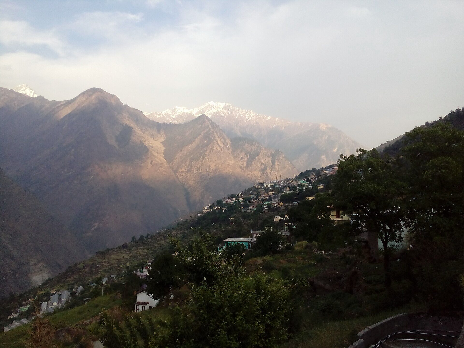
The visible crisis began on 2 January 2023, when residents in the Ravigram and Gandhinagar wards woke to widening cracks in their walls and a sudden gush of muddy water from a JP Group colony in Marwari ward, reportedly from a subterranean aquifer breach.
Timeline
- 2 January: Cracks visible across multiple wards; CM Pushkar Singh Dhami visits.
- 5 January: Uttarakhand government declares Joshimath a “land subsidence zone”.
- 6 January: Demolition of two badly tilted hotels (Malari Inn, Mount View) ordered.
- 8 January: Central panel led by NDMA arrives.
- 12 January: Total affected structures cross 760; 169 families relocated to temporary shelters.
- End of January: Government halts work on NTPC’s Tapovan-Vishnugad tunnel in the vicinity.
Pattern of damage
Cracks were not uniformly distributed. They concentrated in:
- The upper bench of the town (Singhdhar, Manohar Bagh), where slopes are steeper.
- Wards downslope of natural water channels (gadheras).
- Areas above the projected alignment of the NTPC head-race tunnel.
Several houses showed differential settlement — one corner sank faster than another — characteristic of unconsolidated debris losing support.
Geological setting of Joshimath
Joshimath sits at about 1,890 m on the right bank of the Alaknanda, near its confluence with the Dhauliganga.
Paraglacial debris
The town is built almost entirely on paraglacial debris — an old landslide and glacial-moraine deposit left behind when the last glaciers retreated from the upper Alaknanda valley. The deposit is:
- Heterogeneous: boulders, gravel, sand, silt and clay mixed.
- Loose and porous: with high permeability and very low cohesion.
- Saturated for parts of the year by perched water tables and gadhera (mountain stream) flows.
Such debris is geotechnically classified as Class III to IV — entirely unsuitable for sustained heavy or multi-storey construction. Vibrations, pore-pressure changes and toe erosion can trigger creep or slide.
Tectonic context
Joshimath lies between two of the Himalaya’s most important thrusts:
- The Main Central Thrust (MCT) about 10 km south.
- The Vaikrita Thrust running just north of the town.
Both are seismically active. The 1991 Uttarkashi (Mw 6.8) and 1999 Chamoli (Mw 6.6) earthquakes accelerated creep on the Joshimath slope. Long-term GPS data from Wadia Institute show 5–7 mm/year of strain accumulation in the region.
Hydrogeology
Springs and gadheras criss-cross the slope. Auden’s Fault, mapped by JB Auden of GSI in the 1930s, channels groundwater laterally. Disturbing this hydrogeology by tunnelling, blasting, or surface paving alters pore pressures inside the debris pile — and historical observation has linked exactly such triggers to localised subsidence.
NTPC Tapovan-Vishnugad hydro project
The 520 MW Tapovan-Vishnugad hydroelectric project, under construction since 2006, is the single most-cited modern stressor on the Joshimath slope.
Project anatomy
- A diversion dam on the Dhauliganga at Tapovan.
- A 12.1 km head-race tunnel passing under the Joshimath ridge.
- An underground powerhouse near Selang.
Documented incidents
- 24 December 2009: A TBM (tunnel-boring machine) ruptured an aquifer at chainage 3+200, releasing an estimated 60–70 million litres per day for weeks. Local springs dried up; villagers in Selang first reported subsidence.
- 7 February 2021: The Chamoli debris flow destroyed the project’s barrage and trapped workers inside the head-race tunnel, killing about 200. (See GLOFs in India for the Chamoli sequence.)
- 2023: Forensic studies suggested continued seepage and pore-pressure cycling in the tunnel had altered groundwater under Joshimath.
NTPC and the project consultants have publicly contested any direct causal link, citing distance and geological logs. The expert committees that visited in 2023 stopped short of attributing the entire subsidence to the tunnel, but recommended that tunnelling not resume in the vicinity until pore-pressure monitoring was in place.
Mishra Committee 1976: the warning that wasn’t heeded
The most striking element of the Joshimath subsidence 2023 narrative is that it had been forecast almost 50 years earlier.
Context
After a sequence of small landslides in 1970–75 along the Alaknanda, the Uttar Pradesh government (Uttarakhand had not yet been carved out) constituted an expert panel under Mahesh Chandra Mishra, then the Commissioner of Garhwal division. The 18-member panel submitted its report in 1976.
Key findings
- Joshimath is built on deposits of an ancient landslide — sand and stone, not on rock — making it inherently unstable.
- Heavy construction, blasting and excavation should be banned.
- Tree felling and road widening on the slope should be tightly controlled to prevent toe erosion.
- The drainage system of natural streams should be protected; soak pits and septic tanks were not advisable.
- A soil-stabilisation plan including afforestation and slope drainage was recommended.
The report was filed, briefly publicised, and then largely ignored. Tourism expansion, the army’s strategic presence (Joshimath is the base of the IBEX brigade), the construction of NH-7 (now NH-58), unregulated hotel growth and the post-2000 hydropower push all proceeded without the Mishra committee’s safeguards being institutionalised.
Roorkee, CBRI and post-2023 studies
After January 2023, the Centre commissioned eight technical agencies, including IIT-Roorkee, the Central Building Research Institute (CBRI), the National Institute of Hydrology, GSI, Wadia Institute, ISRO, NIDM and the National Geophysical Research Institute.
Headline findings (released 2023–24)
- IIT-Roorkee confirmed that the substrate is overburden of paraglacial origin with very low bearing capacity (50–80 kPa in zones).
- CBRI classified 81% of surveyed buildings as “unsafe under static loads” after the cracking event.
- ISRO’s InSAR analysis (briefly published and then withdrawn for further validation) showed about 5.4 cm of subsidence in some pockets between 27 December 2022 and 8 January 2023, with cumulative sinking of 17 cm over the previous year.
- Wadia Institute mapped active creep and recommended slope-drainage installation.
- NIDM flagged the absence of any city-level disaster risk management plan for Joshimath at the time of the event.
Displacement, compensation and central package
The state government identified 270 families as urgently affected; ~169 were moved to temporary shelters at Pipalkoti, Gauchar and Hemkund Sahib. A multi-pronged package was announced.
Components
- Interim relief: ₹1.5 lakh per family for relocation; ₹4,000/month rental assistance.
- Demolition compensation: Up to ₹3.6 lakh per house for officially demolished structures.
- Long-term reconstruction: Planned new township at Selang and Pipalkoti, with land allotment of 75 m².
- Central package: A ₹1,658 crore package approved in mid-2023 for slope stabilisation, sewerage, road realignment, drainage and rehabilitation.
The pace of disbursement has been contested in the Uttarakhand High Court; residents have pressed for higher compensation reflecting Joshimath’s commercial real-estate values, particularly for hotels.
Himalayan carrying-capacity debate
Joshimath has reopened a question that pre-dates Independence: how much built load can the young Himalaya bear.
Concept
Carrying capacity in a Himalayan context is the maximum population, infrastructure and economic activity a fragile mountain ecosystem can sustain without ecological or geotechnical breakdown. It is a function of slope stability, water availability, sewerage capacity, biodiversity stress and seismic risk.
Policy moves since 2023
- The NGT ordered carrying-capacity studies for all major Himalayan towns in March 2023.
- The Supreme Court in August 2023 directed the Centre to constitute an expert committee to assess Char Dham route carrying capacity.
- The Ministry of Environment has begun consultations on a Himalayan Cities Sustainability Framework.
- States have been asked to designate “no construction zones” in unstable wards, on Joshimath’s model.
The broader hazard map for the Himalaya is increasingly inseparable: subsidence in Joshimath, GLOFs in Sikkim, earthquake risk, and the NDRF’s role as the lead responder all sit on the same vulnerability landscape.
Way forward
A serious response to the Joshimath subsidence 2023 episode needs to convert a one-time scare into a permanent doctrine.
- Implement Mishra Committee 1976 recommendations in letter — moratorium on heavy construction, drainage protection, afforestation.
- Mandatory carrying-capacity studies for every Himalayan town above 1,500 m before fresh sanctions.
- Pore-pressure and ground-deformation monitoring at every major Himalayan tunnel.
- A central law for ecologically sensitive Himalayan zones, with binding land-use rules.
- Risk-informed insurance for residents in identified subsidence corridors.
Frequently Asked Questions
What is the Joshimath subsidence 2023?
The Joshimath subsidence 2023 is the rapid land-sinking event of early January 2023 in which residents of Joshimath in Uttarakhand’s Chamoli district reported widening cracks in over 860 structures, with around 280 declared uninhabitable. The state government declared the town a u0022land subsidence zoneu0022 on 5 January 2023 and the Centre commissioned eight technical agencies to investigate the geological, hydrological and construction causes.
Why is Joshimath geologically unstable?
Joshimath is built almost entirely on paraglacial debris — an old landslide and glacial moraine deposit of loose, heterogeneous, water-saturated material with very low cohesion. It lies between the Main Central Thrust and the Vaikrita Thrust, both seismically active, and the historic 1991 Uttarkashi and 1999 Chamoli earthquakes accelerated creep on its slopes. Springs and gadheras criss-cross the town and channel groundwater laterally.
What did the Mishra Committee 1976 report say?
The 1976 Mishra Committee, set up after small landslides along the Alaknanda, found that Joshimath sits on ancient landslide debris and is inherently unstable. It recommended a ban on heavy construction, blasting and excavation; tight control of tree felling and road widening; protection of natural drainage; and a soil-stabilisation plan combining afforestation and slope drainage. The recommendations were largely ignored for five decades.
What role did the NTPC Tapovan-Vishnugad tunnel play?
NTPC’s 520 MW Tapovan-Vishnugad hydroelectric project includes a 12.1 km head-race tunnel that passes near Joshimath. A TBM ruptured a major aquifer at chainage 3+200 in December 2009, releasing 60–70 million litres per day; this is widely cited as the moment subsidence in nearby Selang began. The 2023 expert committees did not assign the entire crisis to the tunnel but recommended halting tunnelling until pore-pressure monitoring is in place.
What did the IIT-Roorkee and ISRO studies find?
IIT-Roorkee classified the substrate as paraglacial overburden with low bearing capacity (50–80 kPa). CBRI found 81% of surveyed buildings unsafe under static loads. ISRO’s InSAR analysis showed roughly 5.4 cm of subsidence between 27 December 2022 and 8 January 2023, with cumulative sinking of 17 cm over the previous year, before the report was withdrawn for further validation.
What relief package did the Centre announce?
The Centre approved a ₹1,658 crore package in mid-2023 for slope stabilisation, sewerage, road realignment, drainage and rehabilitation, alongside state-level interim relief of ₹1.5 lakh per family, ₹4,000/month rental assistance, and demolition compensation up to ₹3.6 lakh per house. A new township at Selang and Pipalkoti was planned, with 75 m² land allotments for displaced families.
What is Himalayan carrying capacity and why does it matter?
Himalayan carrying capacity is the maximum population, infrastructure and economic load a fragile mountain ecosystem can sustain without ecological or geotechnical breakdown. It depends on slope stability, water availability, sewerage capacity and seismic risk. Joshimath has become the test case because the NGT in March 2023 and the Supreme Court in August 2023 ordered carrying-capacity studies for Himalayan towns and Char Dham routes.
How can a repeat of Joshimath be prevented?
Prevention needs a binding moratorium on heavy construction in identified subsidence corridors, pore-pressure and ground-deformation monitoring at every major Himalayan tunnel, mandatory carrying-capacity studies before fresh sanctions in Himalayan towns above 1,500 m, protection of natural drainage and afforestation along the Mishra Committee lines, and a central law for ecologically sensitive Himalayan zones with binding land-use rules.