

A glacial lake outburst flood (GLOF) is the sudden, catastrophic release of water from a lake dammed by a glacier or moraine. GLOFs in India are now treated as a top-tier Himalayan hazard after three back-to-back disasters — Kedarnath 2013, Chamoli 2021 and Sikkim’s South Lhonak 2023 — exposed the fragility of communities, hydropower projects and pilgrimage routes downstream of fast-melting glaciers. For UPSC, GLOFs in India are a high-yield GS-I geography and GS-III disaster-management topic that links climate change, geomorphology, NDMA’s 2020 revised guidelines, and the new automated early-warning architecture being deployed across Sikkim, Uttarakhand and Himachal Pradesh.
A 2023 ISRO study using Landsat and Sentinel-2 data found that 676 glacial lakes in Indian Himalayan river basins have expanded measurably since 1984, and 130 are categorised as “potentially dangerous” based on volume, dam type and downstream exposure. That inventory, combined with rapidly intensifying monsoon rainfall and earthquake risk in the central Himalaya, makes a recurrence of South Lhonak almost certain within the next decade. The strategic answer is to combine geomorphology, satellite remote sensing, automated sensors and community-based early warning into a single hazard chain.
What is a GLOF and how does one happen
A GLOF is a flash flood triggered when the natural dam holding a glacial lake fails. The dam can be:
- A moraine — an unconsolidated ridge of glacial debris piled at the snout of a retreating glacier.
- An ice barrier — a tongue of glacier ice damming a side valley.
- A combination — moraine reinforced by buried ice (called dead-ice).
Failure mechanisms include:
- Overtopping by a wave from an ice or rock avalanche falling into the lake.
- Piping or seepage through the moraine that progressively enlarges into a breach.
- Settling of buried ice within the moraine, lowering the crest.
- Earthquake shaking that liquefies the moraine.
Once the dam fails, the released water entrains debris from the moraine and channel, forming a debris flow that can move at 5–15 m/s and carry boulders of 10–100 tonnes. Peak discharges of 5,000–15,000 m³/s — comparable to a major river in flood — are possible from lakes of only 30–50 million m³.
Types of glacial lakes in the Indian Himalaya
The Geological Survey of India and ISRO’s National Remote Sensing Centre classify Himalayan glacial lakes into four broad types.
Moraine-dammed lakes
The most numerous and the most dangerous. South Lhonak, Imja (Nepal), Gangotri snout lakes and Chorabari were all moraine-dammed. The moraine is geotechnically weak and often contains buried ice that destabilises with warming.
Ice-dammed lakes
Less common in India; more frequent in Karakoram. The Shyok river has historically been dammed by the Chong Kumdan glacier.
Erosion (cirque or kettle) lakes
Smaller lakes occupying glacially eroded basins. Generally lower hazard but can act as a “second dam” downstream.
Supraglacial lakes
Ponds on the surface of debris-covered glaciers. They can coalesce and develop subglacial drainage that abruptly empties.
Chorabari 2013 and the Kedarnath disaster
The June 2013 Kedarnath disaster, India’s worst Himalayan flood in living memory, included a GLOF-like component.
- A multi-day cloudburst-like rainfall on 16–17 June 2013 delivered 325 mm in 24 hours on a melting snowpack above Kedarnath.
- The small moraine-dammed Chorabari Tal (also called Gandhi Sarovar) above the temple was overtopped and breached around 6:45 am on 17 June.
- The resulting debris flow surged through Kedarnath town in two waves, the second more destructive than the first.
- Combined with simultaneous flash floods across the Mandakini, Alaknanda and Bhagirathi basins, the disaster killed over 6,000 people (official) and left thousands missing.
- It reset the disaster-management narrative for the entire Char Dham circuit.
Subsequent studies (Wadia Institute, IIT-Roorkee, NIH) confirmed Chorabari was not a “classic” GLOF but a rainfall-and-melt-triggered moraine-dam failure — a hybrid event. The episode pushed NDMA, ISRO and the Geological Survey of India to begin a sustained Himalayan glacial-lake inventory.
Chamoli, February 2021
On 7 February 2021, a rock-ice avalanche broke off the Ronti peak (5,600 m) in Uttarakhand’s Chamoli district. The mass slid down, mixed with glacier ice and snow, and turned into a debris flow that ripped through the Rishiganga valley and into the Dhauliganga.
Casualties and impact
- The flow destroyed the small Rishiganga hydropower project (13.2 MW) at Reni.
- It overwhelmed the under-construction NTPC Tapovan-Vishnugad project (520 MW), trapping 140+ workers inside the head-race tunnel.
- Around 200 people died or remained missing; the tunnel recovery operation stretched for weeks.
Why it mattered
Chamoli was not strictly a GLOF — no lake outburst was involved — but it demonstrated the same hazard chain: a high-altitude mass movement triggering a debris flood that devastates downstream infrastructure. It forced a re-examination of Himalayan run-of-river hydropower siting and the very idea of “carrying capacity” of valley floors.
Sikkim South Lhonak, October 2023
The South Lhonak Lake GLOF on the night of 3–4 October 2023 is the clearest, fastest-evolving GLOF event in modern Indian history.
Sequence of events
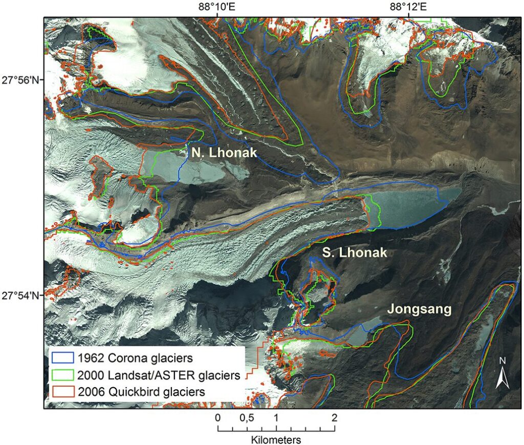
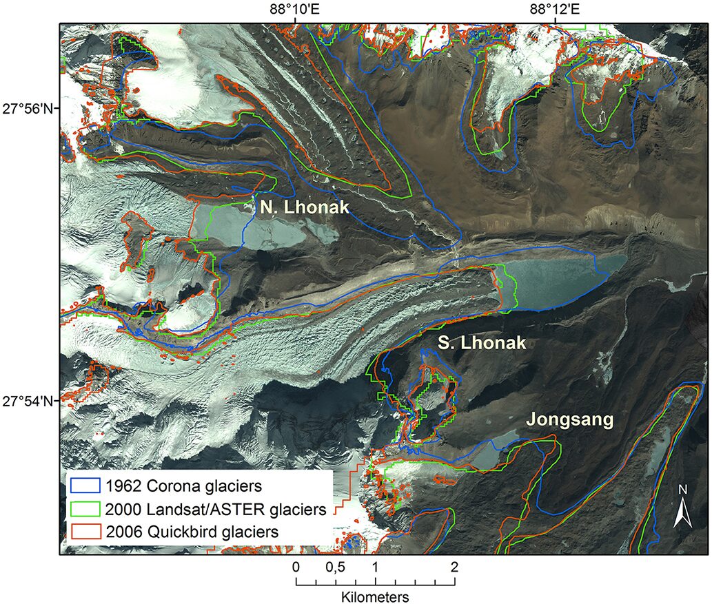
- South Lhonak Lake in north Sikkim, at about 5,200 m, had grown from a few hectares in the 1970s to about 168 hectares by 2023 — a textbook case of glacier retreat creating a moraine-dammed lake.
- On the night of 3 October 2023, a rock-and-permafrost avalanche from the lateral moraine fell into the lake, generating an overtopping wave that breached the moraine.
- An estimated 50 million m³ of water surged down the Lhonak Chu into the Teesta.
- Peak discharge at the Chungthang station of the 1,200 MW Teesta-III dam was several times its spillway design capacity. The concrete-faced rockfill dam was overtopped and failed within minutes.
- The flood travelled 300+ km down the Teesta into West Bengal and Bangladesh.
Damage
- Over 100 deaths, including army personnel at the Bardang camp.
- 1,200+ houses destroyed; 14 bridges washed away across Sikkim.
- The Teesta-III dam, India’s largest hydropower asset in the eastern Himalaya, was wiped out — a single-asset loss estimated at over ₹25,000 crore including downstream damage.
South Lhonak validated nearly every prediction made in NDMA’s 2020 guidelines: it was a moraine-dam failure, triggered by a slope failure, on a lake already flagged as potentially dangerous, on a river crowded with cascade hydropower without GLOF-design margins.
Why the Indian Himalaya is uniquely vulnerable
Multiple factors converge.
- Glacier retreat: ISRO data show 95% of Indian Himalayan glaciers retreating; some at 30–40 m/year.
- Permafrost thaw: Rock slopes above 4,500 m, previously cemented by permafrost, are destabilising.
- Steep relief: Valley walls of 1,500–2,500 m within 5–10 km of the lake amplify debris-flow velocities.
- Monsoon intensification: Cloudbursts and 100+ mm/hour events are more frequent, providing the trigger.
- Seismicity: The Main Himalayan Thrust regularly produces M6+ events.
- Hydropower density: Over 200 projects operational or planned across Teesta, Bhagirathi, Alaknanda, Sutlej, Chenab and Tawang basins, often sited inside or below GLOF flow paths.
NDMA GLOF Guidelines 2020 (revised)
The NDMA’s National Guidelines for Management of GLOFs and LLOFs (Glacial- and Landslide-Lake Outburst Floods), revised in 2020, structure India’s response.
Core prescriptions
- Inventory: Nationwide glacial-lake atlas updated every five years, jointly by ISRO, GSI, CWC and state disaster authorities.
- Hazard rating: Each lake to be classified A/B/C on volume, dam type, and downstream exposure.
- Mitigation: Engineered drawdown of high-hazard lakes (siphon tubes, controlled spillway channels, breach-resistant outlets) — used successfully at Imja in Nepal in 2016.
- Early warning: Multi-sensor automated systems with redundant communications, river-stage sensors, weather radars and community sirens.
- Land-use: Restriction on construction within delineated GLOF inundation corridors and seismic safety norms for hydropower.
- Capacity: Dedicated SDRF battalions trained for high-altitude rescue, complementing the NDRF.
Satellite-based and automated early warning systems
India’s GLOF early-warning architecture has three layers.
Satellite monitoring
ISRO’s National Remote Sensing Centre uses Resourcesat-2A, Cartosat-3 and Sentinel-2 data to track changes in glacial lake area, snout retreat and moraine geometry. The Geological Survey of India and Wadia Institute add InSAR-based ground-deformation monitoring of moraines.
Ground sensors
Automatic weather stations, precipitation gauges, water-level sensors, turbidity meters, accelerometers on moraines and seismographs are being installed at high-priority lakes. Sikkim’s post-2023 plan covers 21 lakes; Uttarakhand has tagged 13. Power and connectivity is the binding constraint — solar panels and satellite-IoT (LoRaWAN / Iridium) are the chosen path.
Community sirens
Sirens with 5–10 km audibility at downstream villages and pilgrimage routes, paired with cell-broadcast SMS and panchayat-level mock drills.
The hazard chain is part of a broader multi-hazard map for the Himalaya that also covers landslides, earthquakes (see earthquake causes and types) and downstream coastal risk (see Indian Ocean tsunami 2004 for cross-hazard linkages between river-borne sediment surges and coastal estuaries).
Way forward
A serious GLOF policy needs:
- A binding national GLOF inventory updated annually.
- Engineered drawdown of the top 10 highest-risk lakes within five years.
- A GLOF-design margin (over and above PMF) for every new and existing Himalayan dam.
- Carrying-capacity studies for Char Dham, Sikkim and Spiti valleys.
- Cross-border data sharing with Nepal and Bhutan, where most upstream lakes sit.
Frequently Asked Questions
What is a glacial lake outburst flood (GLOF)?
A GLOF is the sudden release of water from a lake dammed by a glacier or by a moraine. It can be triggered by overtopping from an avalanche-generated wave, internal piping through the moraine, melt-out of buried ice, or seismic shaking. The released water entrains debris and becomes a fast-moving debris flow capable of destroying villages, bridges and hydropower projects.
How many glacial lakes in the Indian Himalaya are dangerous?
A 2023 ISRO inventory using Landsat and Sentinel-2 data identified 676 expanding glacial lakes in Indian Himalayan basins, of which roughly 130 are categorised as potentially dangerous based on volume, dam type and downstream exposure. The highest concentrations are in Sikkim, north Uttarakhand, Himachal Pradesh and the Tawang basin of Arunachal Pradesh.
What caused the Kedarnath disaster of 2013?
The June 2013 Kedarnath disaster was a hybrid event: a multi-day monsoon cloudburst delivered 325 mm in 24 hours over a melting snowpack, and the small moraine-dammed Chorabari Tal above the temple was overtopped and breached around 6:45 am on 17 June. The resulting debris flow tore through Kedarnath in two waves and killed over 6,000 people across Uttarakhand.
What happened in Chamoli in February 2021?
On 7 February 2021, a rock-ice avalanche from the Ronti peak in Chamoli district mixed with glacier ice and snow and turned into a debris flow that destroyed the Rishiganga hydropower project at Reni, trapped 140+ workers in NTPC’s Tapovan-Vishnugad tunnel, and killed about 200 people. It was not a classic GLOF but illustrated the same high-altitude mass-movement-to-debris-flood chain.
What caused the South Lhonak GLOF in Sikkim in October 2023?
On the night of 3–4 October 2023, a rock-and-permafrost avalanche from the lateral moraine of Sikkim’s South Lhonak Lake fell into the water and generated an overtopping wave that breached the moraine. About 50 million m³ of water surged into the Teesta, overwhelmed the 1,200 MW Teesta-III dam at Chungthang, killed over 100 people, and washed away bridges 300+ km downstream.
What do the NDMA 2020 GLOF Guidelines recommend?
NDMA’s revised 2020 guidelines require a nationwide glacial-lake inventory updated every five years, A/B/C hazard rating of each lake, engineered drawdown of high-hazard lakes through siphons or controlled outlets, multi-sensor automated early-warning systems with redundant communications, GLOF-corridor land-use restrictions for hydropower and habitation, and dedicated high-altitude rescue capacity.
How does climate change increase GLOF risk?
Warming accelerates glacier retreat, exposing new moraine-dammed lakes and enlarging existing ones. Permafrost thaw at 4,500 m+ destabilises previously cemented rock slopes, increasing avalanche triggers. Monsoon intensification raises the chance of cloudburst-coincident events. Combined, these factors mean the Indian Himalaya is now in a high-frequency GLOF regime, with the South Lhonak 2023 event unlikely to be an outlier.
What does India’s GLOF early-warning system look like?
The architecture has three layers: ISRO and GSI satellite monitoring of lake area, snout retreat and InSAR-based moraine deformation; in-situ automated sensors at high-priority lakes including weather stations, water-level gauges, turbidity meters, accelerometers and seismographs powered by solar panels and connected by satellite-IoT; and community sirens with 5–10 km audibility paired with cell-broadcast SMS at downstream villages.
Tell Google you want more of this.
Add Anantam IAS as a preferred sourceOne tap, and this site shows up more often in your own Top Stories, AI Overviews and AI Mode. Remove it any time.






