

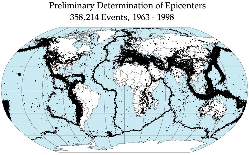
An earthquake is the sudden release of accumulated strain energy in the Earth’s crust, transmitted as seismic waves that shake the ground. Understanding the earthquake causes and types is essential for UPSC geography, disaster management and physical sciences, because India sits on the actively converging Indo-Australian–Eurasian plate boundary and roughly 59% of its landmass is exposed to moderate to severe seismic hazard. The discussion of earthquake causes and types also feeds directly into Disaster Management (GS-III), where the NDMA’s seismic zoning, building codes and response architecture are repeatedly tested.
Elastic Rebound Theory: The Basic Mechanism
The accepted mechanical explanation for tectonic earthquakes is the elastic rebound theory, proposed by Harry Fielding Reid after the 1906 San Francisco earthquake.
- Rocks on either side of a fault behave elastically and deform as stress accumulates.
- When the stress exceeds the rock’s strength, the fault ruptures suddenly.
- The two blocks snap back to a less-strained shape, releasing energy as seismic waves.
This rapid, brittle slip is the earthquake. The energy stored over decades or centuries is released in seconds, which is why earthquakes are so destructive.
Focus and epicentre
- Focus (hypocentre): the point inside the Earth where rupture begins. Classified by depth as shallow (0–70 km), intermediate (70–300 km), or deep (300–700 km).
- Epicentre: the point on the surface directly above the focus. It usually experiences the strongest shaking.
- Isoseismal lines: contours of equal intensity drawn on a map around the epicentre.
Most damaging earthquakes are shallow because their energy reaches the surface with less attenuation.
Seismic Waves: P, S, L
Energy from the focus propagates as different types of seismic waves, recorded on seismographs.
Body waves
- P-waves (Primary, push–pull): longitudinal, fastest (5–8 km/s in crust), travel through solids and liquids. Particles vibrate parallel to wave direction.
- S-waves (Secondary, shear): transverse, slower than P, travel only through solids. The fact that the outer core blocks S-waves was the first evidence that it is liquid.
Surface waves
- L-waves (Long, Love + Rayleigh): travel along the surface, slowest but most destructive. Rayleigh waves produce rolling motion; Love waves cause horizontal shear.
The time gap between P and S waves at a station gives the distance to the epicentre; data from at least three stations triangulate the location.
Magnitude vs Intensity
A common UPSC confusion is magnitude versus intensity. They measure different things.
Magnitude
- Richter scale (M_L): developed by Charles Richter (1935) for southern California; logarithmic, based on the largest amplitude on a Wood–Anderson seismograph. Each whole number increase represents a 10× rise in amplitude and ~32× in energy. Reliable only up to about M 6.5.
- Moment Magnitude scale (M_w): the modern global standard, introduced by Hanks and Kanamori (1979), based on the seismic moment (area of rupture × slip × rigidity). It does not saturate at high values and is preferred for earthquakes above M 7.
- Body-wave magnitude (m_b) and surface-wave magnitude (M_s) are older measures still in use for specific applications.
Intensity
- Modified Mercalli Intensity (MMI) scale: I (not felt) to XII (total destruction). Based on observed shaking and damage, not instruments.
- MSK-64 scale: used in India and several other countries.
- Intensity varies with distance, geology and construction quality; magnitude is a single value for a given event.
Types of Earthquakes (Causal Classification)
Beyond plate-boundary events, earthquakes have several other causes.
Tectonic earthquakes
Caused by sudden movement along faults at plate boundaries. They account for the vast majority of seismicity worldwide. Most large events along the Himalayan front (Nepal 2015), the Ring of Fire, and the Andaman–Sumatra arc (2004) are tectonic. The Andaman–Sumatra event triggered the 2004 Indian Ocean tsunami, the deadliest of modern times.
Volcanic earthquakes
Linked to magma movement, gas pressure or chamber collapse beneath a volcano. They are usually small but swarm-like, and often precede eruptions — for example before Mt St Helens (1980) or Mt Etna’s frequent unrest. The full geodynamic context is in the plate tectonics theory.
Collapse earthquakes
Small tremors caused by the collapse of underground caverns, mine roofs, or solution cavities in karst regions. They are localised and rarely cross magnitude 5.
Explosion earthquakes
Triggered by chemical or nuclear explosions. The seismic signal is sharp, has a different waveform from tectonic events, and is used by the CTBTO to detect clandestine nuclear tests, such as those by North Korea.
Induced (anthropogenic) earthquakes
Caused by human activity:
- Reservoir-induced: water loading of large dams stresses underlying faults. Koyna (1967, M 6.5) in Maharashtra is the world’s most famous reservoir-triggered earthquake. The Hoover Dam and Three Gorges have shown similar effects.
- Mining-induced: deep mining alters stress, as in the South African gold belt.
- Hydraulic fracturing and wastewater injection: the rise of induced seismicity in Oklahoma is a US case study.
- Geothermal extraction: Basel (Switzerland), Pohang (South Korea, 2017).
Plutonic earthquakes
Deep-focus earthquakes (300–700 km) generated by phase transitions or dehydration in subducting slabs. They occur beneath the Sea of Okhotsk and Bolivia.
Distribution of Earthquakes
Global seismicity is concentrated in three belts that mirror plate boundaries:
- Circum-Pacific belt (the Ring of Fire) — about 80% of large earthquakes.
- Alpine–Himalayan belt — from the Mediterranean through Iran, the Himalayas, and into Indonesia — about 15%.
- Mid-oceanic ridge system — shallow, low-magnitude events.
A few are intra-plate (Latur 1993, Bhuj 2001) and reflect ancient faults reactivating under regional stress.
Earthquakes in India: Seismic Zones
The Bureau of Indian Standards’ IS 1893 (current version 2016) divides India into four zones, replacing the earlier five-zone map. The zone is defined by expected MSK intensity.
Seismic Zone II (Low damage risk)
- MSK intensity VI or less, PGA ~0.10g.
- Covers parts of peninsular India: large parts of Karnataka, Tamil Nadu, southern Andhra Pradesh and Telangana.
Seismic Zone III (Moderate)
- MSK VII, PGA ~0.16g.
- Includes Kerala, Goa, Lakshadweep, parts of Maharashtra, Madhya Pradesh, Odisha, West Bengal, Jharkhand, Bihar plains, Uttar Pradesh, Punjab, Haryana and Rajasthan.
Seismic Zone IV (High)
- MSK VIII, PGA ~0.24g.
- Delhi NCR, remaining Himalayan foothills, parts of Jammu, Himachal, Bihar–Nepal border, Sikkim, North Bengal, parts of Maharashtra (Killari), and Gujarat (Surat–Vadodara).
Seismic Zone V (Very high)
- MSK IX or more, PGA ~0.36g.
- Kashmir Valley, Western and Central Himalaya, North-East India (entire), Kachchh region of Gujarat, Andaman and Nicobar Islands, and parts of north Bihar.
About 11% of India lies in Zone V, 18% in Zone IV, 30% in Zone III, and 41% in Zone II.
Major Indian Earthquakes
- Assam (1897): M 8.1, Shillong Plateau, devastating.
- Kangra (1905): M 7.8, Himachal Pradesh.
- Bihar–Nepal (1934): M 8.0, ~10,000 deaths.
- Assam–Tibet (1950): M 8.6, largest continental earthquake in modern times.
- Koyna (1967): M 6.5, reservoir-induced.
- Uttarkashi (1991): M 6.8.
- Latur (1993): M 6.4, intra-plate.
- Jabalpur (1997): M 6.0.
- Chamoli (1999): M 6.8.
- Bhuj (2001): M 7.7, ~20,000 deaths.
- Andaman–Sumatra (2004): M 9.1–9.3, triggered the great tsunami.
- Sikkim (2011): M 6.9.
- Nepal–India (2015): M 7.8, Gorkha event, ~9,000 deaths in Nepal, damage in Bihar and UP.
Earthquake Hazard Management in India
The National Disaster Management Authority (NDMA), set up under the Disaster Management Act 2005, frames national guidelines on seismic safety, including:
- National Building Code (NBC 2016) compliance.
- Retrofitting of schools, hospitals and lifeline buildings.
- Seismic micro-zonation of cities (Delhi, Guwahati, Chennai, Kolkata, Bengaluru).
- National Earthquake Risk Mitigation Project.
The Indian Seismological Centre under the National Centre for Seismology (NCS), Ministry of Earth Sciences, operates the national seismic network of 152+ stations and provides public alerts. NDRF battalions are deployed for search and rescue, and the BIS continually updates IS 1893 and IS 13920 (ductile detailing of RC structures).
The conceptual link between earthquakes, tsunamis and plate motion is best appreciated by reading our explainer on the plate tectonics theory alongside this article and the tsunami causes and formation piece.
Frequently Asked Questions
What are the main causes of earthquakes?
Most earthquakes are tectonic — caused by sudden slip along faults at plate boundaries. Other causes include volcanic activity, collapse of underground cavities, explosions, and human-induced triggers such as reservoir filling, mining and fluid injection.
What is elastic rebound theory?
Proposed by H.F. Reid in 1910, elastic rebound theory states that rocks under stress deform elastically until they fail at a fault, then snap back to a less-strained shape, releasing the stored energy as seismic waves — the earthquake itself.
What is the difference between focus and epicentre?
The focus or hypocentre is the point inside the Earth where the rupture starts. The epicentre is the point on the surface directly above the focus.
What are the types of seismic waves?
There are three types: P-waves (longitudinal, fastest, pass through solids and liquids), S-waves (transverse, slower, only through solids), and L-waves or surface waves (Love and Rayleigh) which travel along the surface and cause most damage.
What is the difference between Richter and Mercalli scales?
The Richter scale measures the magnitude — the energy released — using instrument readings. The Modified Mercalli scale measures intensity — the observed shaking and damage at a location. Magnitude is one value per earthquake; intensity varies with distance and geology.
How many seismic zones does India have?
India is divided into four seismic zones (II, III, IV and V) under IS 1893:2016, with Zone V being the most hazardous. About 59% of India lies in Zones III–V, with the entire North-East, Kashmir, Kachchh and Andaman in Zone V.
Which is the deadliest earthquake in modern India?
The Bhuj earthquake of 26 January 2001 in Gujarat (M 7.7) killed about 20,000 people, injured 167,000 and destroyed nearly 400,000 homes, making it the deadliest Indian earthquake of the 21st century.
What role does the NDMA play in earthquake management?
The National Disaster Management Authority frames national guidelines, supervises seismic micro-zonation, drives retrofitting of critical buildings, coordinates NDRF deployment for response, and integrates seismic safety into the National Building Code.
Tell Google you want more of this.
Add Anantam IAS as a preferred sourceOne tap, and this site shows up more often in your own Top Stories, AI Overviews and AI Mode. Remove it any time.






