Krishnarajasagara (KRS) Dam: Location, River, Height & Significance
The Krishna Raja Sagara Dam on the Kaveri near Mysuru is a princely-Mysore engineering landmark — and the upstream pressure point at the heart of the Karnataka–Tamil Nadu Cauvery water dispute.
Stand on the parapet of the Krishna Raja Sagara dam and you’re looking at two things at once. One is a beautiful piece of early-twentieth-century engineering — a long masonry wall holding back the Kaveri, with the terraced Brindavan Gardens spilling down behind it and a couple of million tourists a year wandering the lawns. The other is a political pressure point. Every monsoon, the level behind this wall is read like a barometer in two state capitals, because what Karnataka stores here decides how much water reaches Tamil Nadu downstream.
So the KRS dam is rarely just a dam in the news. It’s the place where physical geography, princely-era history, and one of India’s longest-running interstate quarrels meet. Get the dam right — the river it sits on, who built it and why, what it does, and why its reservoir level can trigger a political crisis — and you’ve got a topic that pays off across geography, governance, and federalism.
What and Where: The KRS Dam on the Kaveri
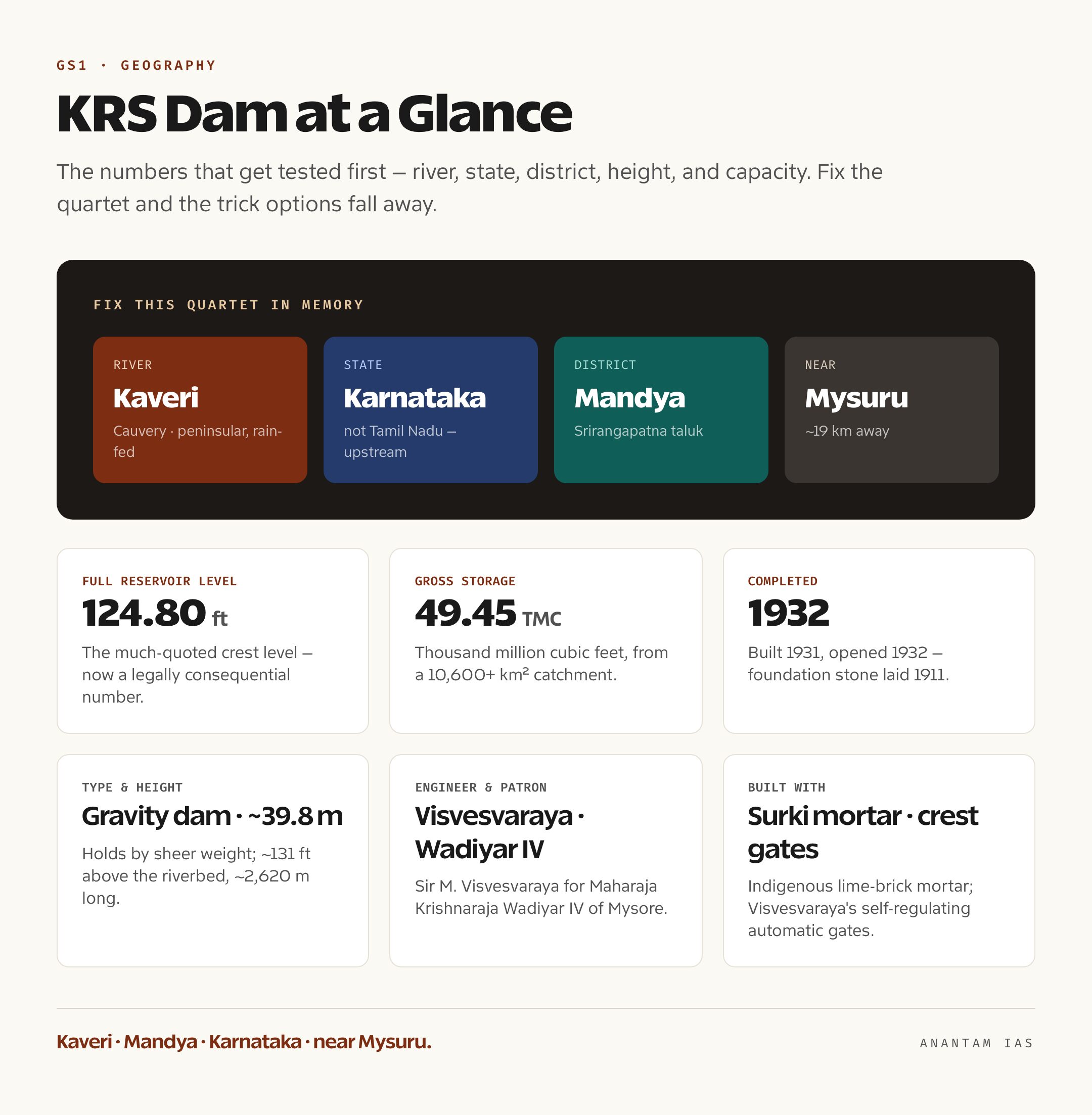
The Krishna Raja Sagara dam, almost always shortened to KRS, sits across the Kaveri (Cauvery) river in Srirangapatna taluk of Mandya district, Karnataka, roughly 19 kilometres from the city of Mysuru. It’s named after Krishnaraja Wadiyar IV, the Maharaja of Mysore under whose reign it was built, and the reservoir it created carries the same name — Krishna Raja Sagara, literally “the sea of Krishnaraja.”
The river underneath matters as much as the dam. The Kaveri rises at Talakaveri in the Brahmagiri Hills of the Western Ghats, in Karnataka’s Kodagu (Coorg) district, then runs south-east through Karnataka and Tamil Nadu before fanning out into a delta and emptying into the Bay of Bengal. KRS sits in the upper reaches of that journey. And that single fact — upstream, in Karnataka, on a river that two states share — is what turns an irrigation dam into a flashpoint. Whatever is held back here is water that does not, for now, flow to the farms and cities below.
For the basics that get tested first: the dam is on the Kaveri, in Mandya district, in Karnataka, near Mysuru. Get that quartet fixed in memory and most of the trick options fall away. The Kaveri is a peninsular, largely rain-fed river that depends on both the south-west and the retreating north-east monsoon, which is exactly why a weak monsoon year sets off the dispute we’ll come to later.
Engineering and History: Visvesvaraya’s Masonry Wall
The KRS story is really the story of two men and a shortage. The Maharaja, Krishnaraja Wadiyar IV, wanted to drought-proof the Mysore heartland and power his state’s industrial ambitions. The engineer who made it happen was Sir Mokshagundam Visvesvaraya — the same Visvesvaraya whose birthday, 15 September, India still marks as Engineers’ Day. The foundation stone went down on 11 November 1911, construction ran for two decades with thousands of labourers on site, and the dam was completed in 1931 and opened in 1932.
Technically, KRS is a gravity dam — it holds back water by sheer weight rather than by arching against the valley walls. It stands about 39.8 metres (roughly 131 feet) above the riverbed and stretches some 2,620 metres across the valley, and its full reservoir level is the much-quoted 124.80 feet, at which it impounds a gross storage of about 49.45 TMC (thousand million cubic feet) drawn from a catchment of over 10,600 square kilometres. Two engineering details are worth knowing because they’re distinctively Visvesvaraya. First, with imported Portland cement scarce and expensive, the dam was built largely with surki mortar — a traditional lime-and-burnt-brick-powder mix — proving a homegrown material could do the job. Second, the spillway was fitted with automatic crest gates that open and shut as the water rises and falls, a self-regulating sluice design Visvesvaraya patented; the gates were cast at the Mysore iron works at Bhadravati. For a princely state to build this scale of structure with local materials and indigenous design, decades before Independence, is exactly why it’s remembered as a landmark of self-reliant Indian engineering.
The dam also slotted into an even older piece of Mysore’s modernity. A short distance downstream, the Shivanasamudra hydroelectric station had begun generating power in 1902 — the first hydroelectric station of its scale in Asia — sending electricity 147 kilometres to the Kolar Gold Fields and, by 1905, making Bengaluru one of the first Indian cities to be lit electrically. KRS, completed three decades later, gave that whole system something it had lacked: a large upstream reservoir to even out the Kaveri’s wild seasonal swings, storing the monsoon surplus so irrigation and power didn’t collapse in the dry months.
Purposes and Significance: Water, Crops, and Power
KRS was never a single-purpose structure, and that’s the point. Its first job is irrigation. The reservoir feeds the Visvesvaraya Canal and a network of distributaries that water well over a lakh hectares across Mandya and Mysuru districts, turning a once drought-prone tract into one of Karnataka’s most productive farm belts — Mandya is sugarcane-and-paddy country precisely because KRS made dependable irrigation possible. The canal supports both the kharif (monsoon) and rabi (winter) cropping seasons, which is why a half-empty reservoir in a bad year lands directly on farmers’ incomes.
Its second job is drinking water, and this has only grown more important. KRS supplies water to Mysuru and Mandya, and — crucially — it’s a major source for Bengaluru’s drinking supply through the Cauvery Water Supply Scheme. A metropolis of well over a crore people leaning on this reservoir is a relatively modern pressure the dam’s designers never planned for, and it has reshaped how Karnataka argues its case: drinking water for Bengaluru is now treated as a near-non-negotiable demand on the Kaveri.
Its third job is hydropower and flow regulation. By storing the monsoon flood and releasing it steadily, KRS lets downstream stations like Shivanasamudra generate more reliably and softens the Kaveri’s seasonal extremes. It isn’t primarily a flood-control dam, but it does moderate peak flows into the Mandya plains. Add the Brindavan Gardens — the terraced ornamental garden with its illuminated musical fountains, laid out from 1927 under Diwan Mirza Ismail and designed by the German horticulturist G.H. Krumbiegel, today drawing close to two million visitors a year — and you have a structure that irrigates, supplies, generates, and earns tourism revenue all at once. That multipurpose character is exactly what the syllabus means by a “multipurpose river valley project.”
But the ledger has a cost side, and a good answer says so. Filling the reservoir submerged a wide tract of land and displaced villages in the Mandya region nearly a century ago, the kind of resettlement question that still dogs every large dam. Nine decades of silt have eaten into the live storage, so the reservoir today holds less usable water than its design figure suggests — a slow squeeze that makes deficit years bite harder. And by capping the Kaveri’s natural flood pulse, the dam has altered the river’s downstream ecology. None of this cancels the benefits; it just means KRS, like every big dam, is a trade-off between stored security upstream and a changed river below.
The Cauvery Dimension: Why KRS Becomes a Flashpoint
Here’s where the dam stops being an engineering story and becomes a federalism one. Karnataka and Tamil Nadu have fought over the Kaveri for more than a century, and the quarrel is structurally simple: Karnataka is upstream, Tamil Nadu downstream, the river is rain-fed, and in a deficient monsoon there isn’t enough to satisfy both. KRS, as Karnataka’s biggest storage in the basin, is the upstream tap. Tamil Nadu watches its level obsessively, because water held at KRS is water not yet flowing to the Cauvery delta and the Mettur dam (Stanley Reservoir), Tamil Nadu’s own big reservoir that opens each June to start delta cultivation.
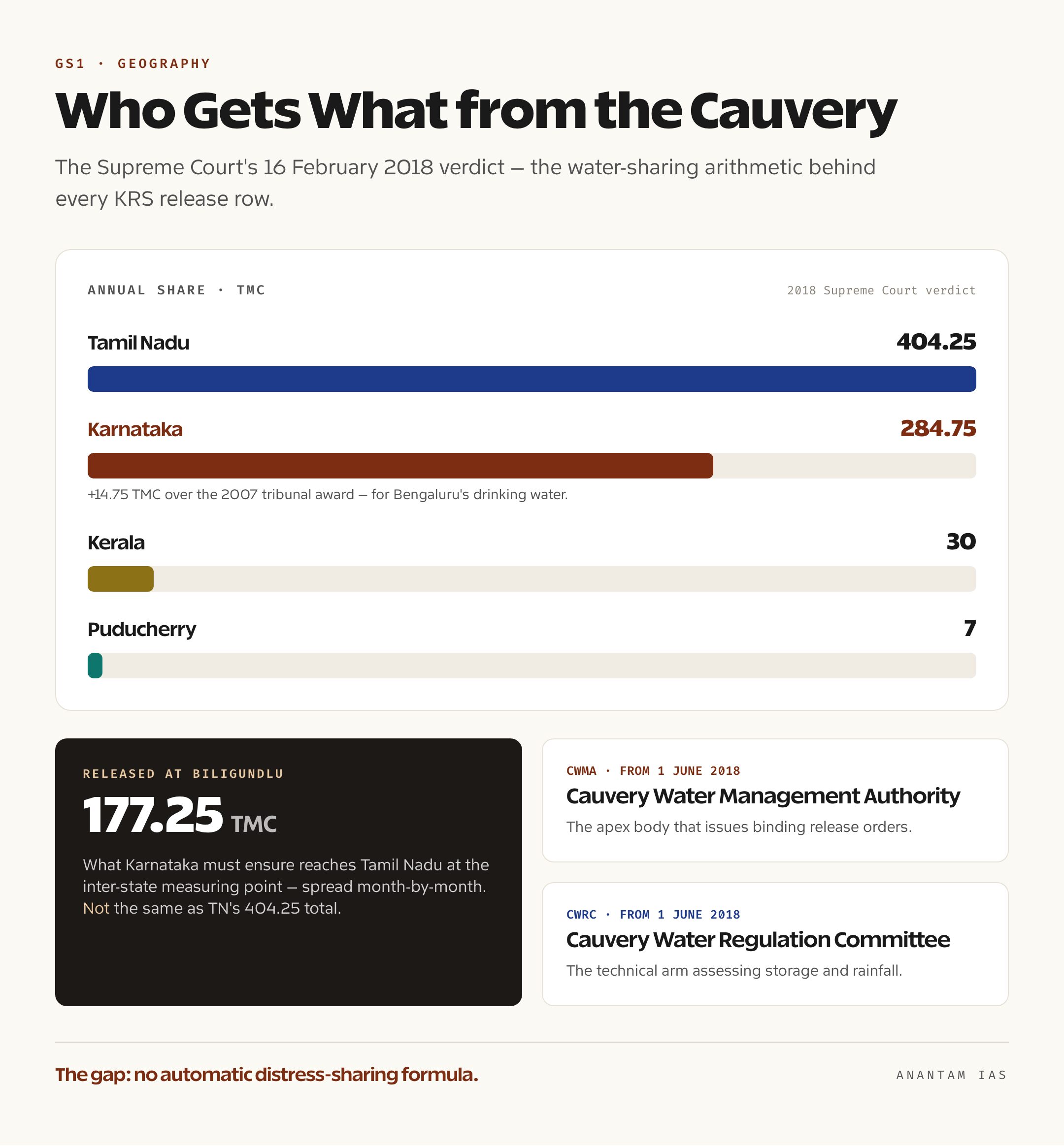
The dispute runs on a stack of institutions worth knowing in order. Interstate river-water disputes are governed by Article 262 of the Constitution and the Inter-State River Water Disputes Act of 1956, which lets the Centre set up a tribunal and bars ordinary courts from the water-sharing question itself. On that basis the Cauvery Water Disputes Tribunal was constituted in 1990. It gave its final award in 2007, allotting the bulk of the basin’s water to Tamil Nadu and Karnataka with smaller shares to Kerala and Puducherry. The Supreme Court then heard appeals and, on 16 February 2018, delivered the verdict that now governs everything: Tamil Nadu’s annual share was set at 404.25 TMC, Karnataka’s at 284.75 TMC, Kerala’s at 30 TMC and Puducherry’s at 7 TMC. The court cut Tamil Nadu’s earlier figure and handed Karnataka 14.75 TMC more than the tribunal had — explicitly recognising Bengaluru’s drinking-water needs. In operational terms, Karnataka must ensure 177.25 TMC reaches Tamil Nadu at Biligundlu, the inter-state measuring point on the river, spread across the year on a month-by-month schedule.
To enforce that, the 2018 verdict created two bodies, both operational from 1 June 2018: the Cauvery Water Management Authority (CWMA), the apex body that issues binding release orders, and the Cauvery Water Regulation Committee (CWRC), the technical arm that assesses storage and rainfall and advises the authority. In a normal year the system runs quietly. The fights happen in distress years, because the 2018 verdict never fixed a clear formula for sharing shortages pro-rata when the monsoon fails. So in September 2023, with the basin in drought, Tamil Nadu demanded large releases while Karnataka pleaded that KRS and its sister reservoirs simply didn’t hold enough even for its own drinking and standing crops; the CWMA’s compromise — directing Karnataka to ensure 5,000 cusecs at Biligundlu — satisfied neither side and ended up back before the Supreme Court. The pattern repeats: a weak monsoon, a low KRS level, competing claims, a CWMA order, street protests in both states, and litigation. As recently as the 2026 pre-monsoon season, with KRS sitting around 81 feet — well below its 124.80-foot crest — and a weak monsoon forecast clouding Mettur’s customary June opening, the same anxieties were back in the headlines.
It’s also worth noting one correction the 2018 ruling forced on older textbooks: the reservoir level at KRS is now a legally consequential number, not just a tourist statistic. When the dam fills, as it did for an unusually long run after the strong 2024 monsoon, releases flow easily and the dispute goes quiet. When it doesn’t, the same wall becomes the most contested water in South India.
The Way Forward: From Quarrel to Cooperation
The honest diagnosis is that the Cauvery is an over-allocated, rain-dependent basin where demand has outgrown a finite, erratic supply — and no tribunal order can manufacture water that the monsoon didn’t deliver. So the durable fixes lie less in courtrooms than in how the basin is managed as a whole. The most urgent gap is a clear, automatic distress-sharing formula: an agreed, transparent rule for cutting everyone’s share pro-rata in a deficit year, so that drought triggers arithmetic rather than litigation. The CWMA was meant to depoliticise these calls, and strengthening its authority and its data — real-time, jointly trusted measurement of inflows and storage at points like KRS and Biligundlu — would take heat out of every release decision.
Beyond institutions, the basin needs to use less and waste less. Both states grow water-thirsty paddy and sugarcane in the command areas KRS and Mettur feed; a shift toward micro-irrigation, less water-intensive crops, and better canal efficiency would stretch the same flow further. Reviving tanks and recharging groundwater across the basin reduces the all-or-nothing dependence on big reservoirs. And for Bengaluru — the demand that keeps growing — recycling and rainwater harvesting matter as much as any release from the dam. KRS will keep doing what Visvesvaraya designed it to do. The question for the next century is whether the states sharing the Kaveri can treat it as one river to be managed together, rather than a line of dams to be fought over reservoir by reservoir.
For Your Mains Answer
KRS is unusually flexible across the syllabus. It fits GS Paper 1 under physical geography and multipurpose river valley projects (the Kaveri basin, dams, irrigation), and it sits squarely in GS Paper 2 under federalism and interstate disputes — Article 262, the Inter-State River Water Disputes Act, tribunals, and the CWMA. It can also surface in GS Paper 3 as a resource-management and agriculture question. Treat the dam as the concrete anchor for a larger argument about cooperative federalism and water governance.
How to Build the Answer
Lead with location and function — Kaveri, Karnataka, multipurpose — then pivot fast to the real meat: why an upstream dam in a shared, rain-fed basin becomes a federal problem. Use KRS as the upstream node, Biligundlu as the measuring point, Mettur as the downstream stake. Then layer the institutions in order (Article 262 → 1956 Act → 1990 Tribunal → 2007 award → 2018 SC verdict → CWMA/CWRC) and close on the distress-sharing gap and the way forward.
Common Mistakes to Avoid
Don’t put KRS in Tamil Nadu or on the wrong river. Don’t confuse the figures: Tamil Nadu’s total share is 404.25 TMC, but the quantity Karnataka must release at Biligundlu is 177.25 TMC — different numbers measuring different things. Don’t say ordinary courts settle these disputes; Article 262 bars that, even though the Supreme Court heard the 2018 appeal. And don’t reduce the issue to “Karnataka is selfish” — the deficit-year shortage is real on both sides.
A Compact Answer Spine
KRS on the upper Kaveri, multipurpose (irrigation, Bengaluru drinking water, power) → upstream storage in a shared rain-fed basin → Article 262 and the 1956 Act → 1990 Tribunal, 2007 award, 2018 SC verdict (TN 404.25, Karnataka 284.75, 177.25 at Biligundlu) → CWMA and CWRC from 2018 → distress-year flashpoints (2023, 2026) → missing distress-sharing formula → cooperative basin management as the way forward.
Diagram or Flowchart Idea
Draw the Kaveri as a single arrow from Talakaveri (Western Ghats) to the Bay of Bengal. Mark KRS upstream in Karnataka, Biligundlu as the inter-state gate in the middle, and Mettur downstream in Tamil Nadu. A clean upstream-to-downstream schematic instantly shows why storage at KRS controls the quarrel.
A Balanced-Conclusion Line
End on the structural truth: the Cauvery is over-allocated and monsoon-dependent, so the lasting solution is a transparent distress-sharing rule and demand-side restraint, not another round of litigation over the same reservoir.
How to Use Data Without Cramming
Carry three anchors and no more: completed 1932 (Visvesvaraya, princely Mysore); 124.80 ft full level / 49.45 TMC; and the 2018 split of 404.25 (TN) and 284.75 (Karnataka), with 177.25 released at Biligundlu. Those land the geography, the engineering, and the dispute in one breath.
FAQ
On which river and in which state is the KRS dam? The Krishna Raja Sagara dam is built across the Kaveri (Cauvery) river in Srirangapatna taluk of Mandya district, Karnataka, about 19 kilometres from Mysuru. The Kaveri rises at Talakaveri in the Western Ghats and flows through Karnataka and Tamil Nadu to the Bay of Bengal, which is why KRS sits in the basin’s contested upper reaches.
Who built the KRS dam and when? It was built by the princely state of Mysore under Maharaja Krishnaraja Wadiyar IV, with Sir M. Visvesvaraya as chief engineer. The foundation stone was laid in 1911, construction ran about two decades, and the dam was completed in 1931 and opened in 1932 — using indigenous surki mortar and Visvesvaraya’s self-regulating automatic crest gates.
Why is the KRS dam central to the Cauvery dispute? As Karnataka’s largest reservoir in the basin, KRS is the upstream tap on a river two states share. Water stored here is water not yet reaching Tamil Nadu’s delta and the Mettur dam. So its level, and how much Karnataka releases at Biligundlu, becomes the trigger for conflict in every deficient-monsoon year, mediated now by the Cauvery Water Management Authority.
What did the 2018 Supreme Court verdict decide? On 16 February 2018 the Supreme Court fixed annual Cauvery shares at 404.25 TMC for Tamil Nadu, 284.75 TMC for Karnataka, 30 TMC for Kerala and 7 TMC for Puducherry — giving Karnataka 14.75 TMC more than the 2007 tribunal award, partly for Bengaluru’s drinking water. Karnataka must ensure 177.25 TMC reaches Tamil Nadu at Biligundlu, and the CWMA and CWRC were created to enforce the schedule.
Practice Questions
Prelims MCQs
- The Krishna Raja Sagara (KRS) dam is built across which river?
(a) Krishna
(b) Tungabhadra
(c) Kaveri
(d) Godavari
Answer: (c) The KRS dam impounds the Kaveri (Cauvery) river in Mandya district, Karnataka. - Consider the following about the KRS dam:
1. It lies in Tamil Nadu.
2. It was completed during the reign of Krishnaraja Wadiyar IV.
3. Sir M. Visvesvaraya was its chief engineer. Which are correct?
(a) 1 and 2 only
(b) 2 and 3 only
(c) 1 and 3 only
(d) 1, 2 and 3
Answer: (b) KRS is in Karnataka (Mandya district), not Tamil Nadu; it was completed in 1932 under Wadiyar IV with Visvesvaraya as chief engineer. - The Kaveri river originates at Talakaveri, which lies in:
(a) the Nilgiri Hills of Tamil Nadu
(b) the Brahmagiri Hills of the Western Ghats in Karnataka
(c) the Anaimalai Hills of Kerala
(d) the Eastern Ghats of Andhra Pradesh
Answer: (b) Talakaveri is in the Brahmagiri Hills of the Western Ghats, in Kodagu district, Karnataka. - Interstate river-water disputes in India are dealt with primarily under:
(a) Article 131 and the Supreme Court’s original jurisdiction
(b) Article 262 and the Inter-State River Water Disputes Act, 1956
(c) Article 263 and the Inter-State Council
(d) Article 252 and the River Boards Act, 1956
Answer: (b) Article 262 empowers Parliament to legislate on such disputes and bar court jurisdiction; the 1956 Act provides the tribunal mechanism. - With reference to the Cauvery dispute, consider:
1. The Cauvery Water Management Authority was set up in 2018.
2. Biligundlu is the inter-state point at which Karnataka’s releases to Tamil Nadu are measured.
3. The Mettur dam is located in Karnataka. Which are correct?
(a) 1 and 2 only
(b) 2 and 3 only
(c) 1 and 3 only
(d) 1, 2 and 3
Answer: (a) The CWMA began functioning on 1 June 2018 and Biligundlu is the measuring point; the Mettur dam (Stanley Reservoir) is in Tamil Nadu, downstream, not Karnataka.
Mains Practice Questions
- “An upstream dam in a shared, rain-fed basin is a federal problem as much as an engineering one.” Examine this statement with reference to the Krishna Raja Sagara dam and the Cauvery water dispute. (15 marks, 250 words)
- Trace the institutional evolution of the Cauvery water-sharing mechanism from the Inter-State River Water Disputes Act, 1956 to the Cauvery Water Management Authority. How far has it succeeded in depoliticising water allocation? (15 marks, 250 words)
- Multipurpose river valley projects were meant to be “temples of modern India.” Using the KRS dam as a case study, evaluate the benefits and the social and ecological costs of such projects. (10 marks, 150 words)
- The absence of a clear distress-sharing formula lies at the root of recurring Cauvery flare-ups. Suggest institutional and demand-side measures to make interstate river-water sharing more cooperative. (15 marks, 250 words)
- Discuss how princely Mysore’s investment in the KRS dam and the Shivanasamudra hydroelectric station reflected an early model of self-reliant, infrastructure-led development in India. (10 marks, 150 words)