Largest River in India: Ganga, Godavari and Top Rivers Ranked
The largest river in India is the Ganga by length within Indian territory. Compare Ganga, Godavari, Krishna, Yamuna, Narmada with length, basin and UPSC notes.
The largest river in India by length within Indian territory is the Ganga, flowing approximately 2,525 km from the Gangotri Glacier in Uttarakhand to the Bay of Bengal. By total length including Bangladesh, it remains the longest river associated with India. Among peninsular rivers, the Godavari is the longest, often called Dakshin Ganga, at about 1,465 km. Depending on how "largest" is defined — by length, by basin area, by discharge, or by cultural weight — different rivers top the list. For UPSC aspirants, understanding these distinctions and the ranking of major Indian rivers is essential for GS-I physical geography.
Defining "Largest"
"Largest" in river geography can refer to:
- Length within India — useful for a national ranking
- Total length including foreign territory
- Catchment / basin area
- Mean annual discharge (water volume)
- Sediment load
By most UPSC-style definitions, India's "largest river" is the Ganga.
Top Rivers of India by Length in Indian Territory
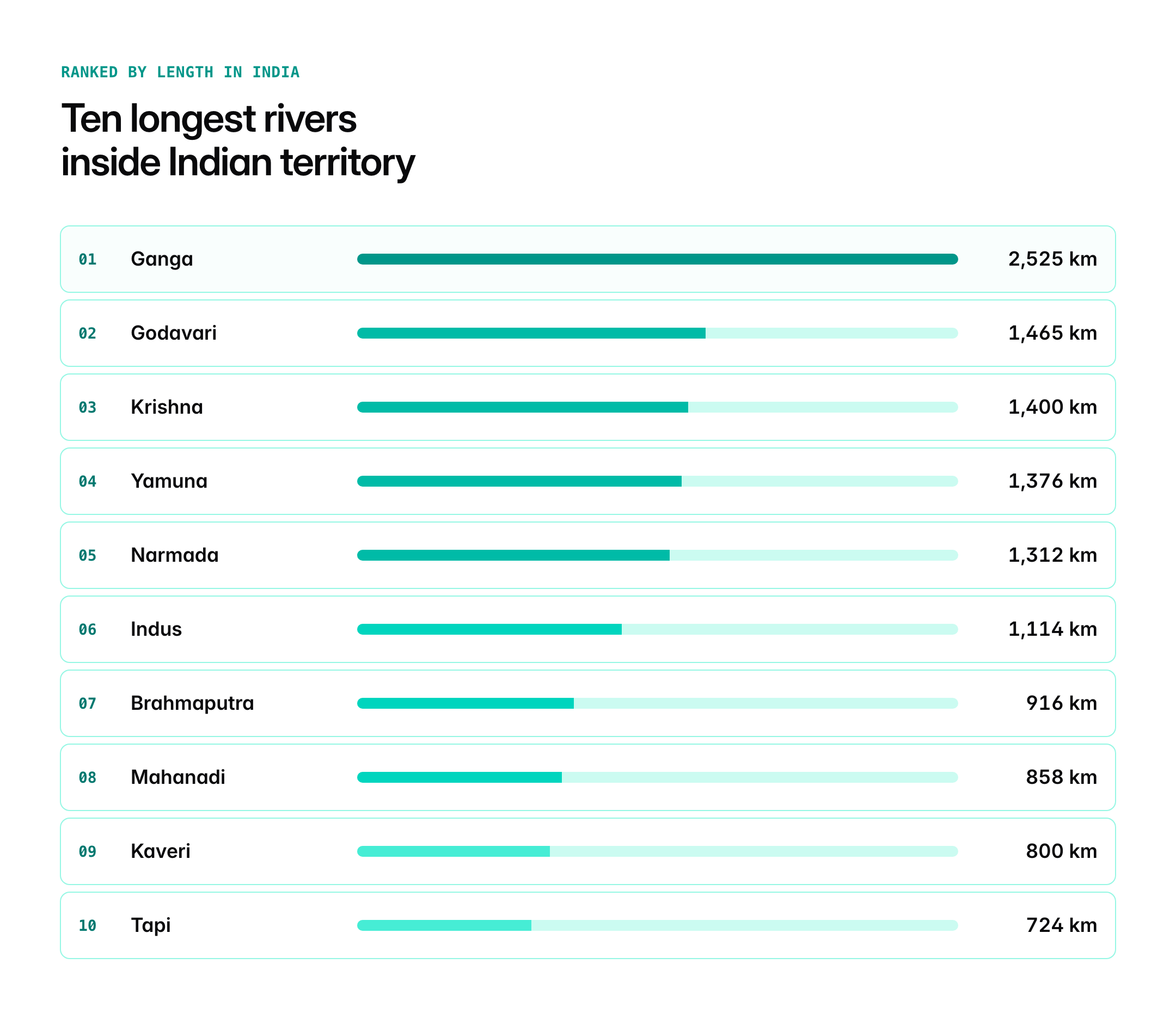
| Rank | River | Length in India (approx.) | Source | Outflow |
|---|---|---|---|---|
| 1 | Ganga | 2,525 km | Gangotri Glacier, Uttarakhand | Bay of Bengal |
| 2 | Godavari | 1,465 km | Trimbakeshwar, Maharashtra | Bay of Bengal |
| 3 | Krishna | 1,400 km | Mahabaleshwar, Maharashtra | Bay of Bengal |
| 4 | Yamuna | 1,376 km | Yamunotri Glacier, Uttarakhand | Merges with Ganga at Prayagraj |
| 5 | Narmada | 1,312 km | Amarkantak, Madhya Pradesh | Arabian Sea |
| 6 | Indus (in India) | ~1,114 km | Near Mount Kailash, Tibet | Arabian Sea (via Pakistan) |
| 7 | Brahmaputra (in India) | ~916 km | Chemayungdung, Tibet | Bay of Bengal (via Bangladesh) |
| 8 | Mahanadi | 858 km | Sihawa, Chhattisgarh | Bay of Bengal |
| 9 | Kaveri | 800 km | Talakaveri, Karnataka | Bay of Bengal |
| 10 | Tapi / Tapti | 724 km | Satpura range, Madhya Pradesh | Arabian Sea |
Note: Length figures vary slightly across sources; these are widely cited estimates used in standard school and competitive-exam textbooks.
1. Ganga: The Largest River
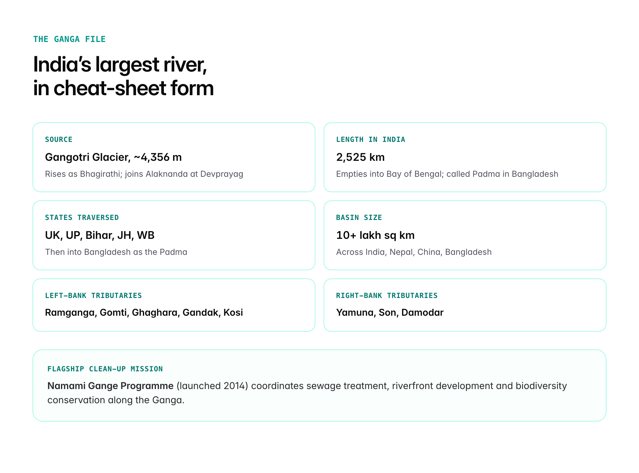
The Ganga rises as the Bhagirathi from the Gangotri Glacier at an elevation of about 4,356 metres. It is joined by the Alaknanda at Devprayag to become the Ganga. It flows through Uttarakhand, Uttar Pradesh, Bihar, Jharkhand and West Bengal before entering Bangladesh as the Padma.
- Major tributaries (left bank): Ramganga, Gomti, Ghaghara, Gandak, Kosi
- Major tributaries (right bank): Yamuna, Son, Damodar
- Cultural and religious centres: Haridwar, Varanasi, Prayagraj, Patna
- Basin size: Over 10 lakh sq km across India, Nepal, China and Bangladesh
- Namami Gange Programme (2014) is the flagship clean-river mission
2. Godavari: The Longest Peninsular River
Often called Dakshin Ganga, the Godavari rises at Trimbakeshwar in Nashik district, Maharashtra, and flows through Maharashtra, Telangana, Andhra Pradesh and parts of Chhattisgarh, Odisha, and Madhya Pradesh.
- Major tributaries: Pravara, Manjira, Penganga, Wardha, Wainganga, Indravati, Sabari
- Coringa delta in Andhra Pradesh is ecologically important
- Polavaram Project is a major multipurpose dam on the Godavari
3. Krishna
Rising at Mahabaleshwar in the Western Ghats, the Krishna flows through Maharashtra, Karnataka, Telangana and Andhra Pradesh before emptying into the Bay of Bengal.
- Tributaries: Bhima, Tungabhadra, Koyna, Ghataprabha, Malaprabha, Musi
- Almatti and Srisailam dams are key infrastructure
4. Yamuna
The longest tributary of the Ganga, the Yamuna rises at the Yamunotri Glacier and merges with the Ganga at Prayagraj (Sangam).
- Tributaries: Chambal, Betwa, Ken, Sind, Tons, Hindon
- Highly polluted in the NCR stretch; subject of Yamuna Action Plan
5. Narmada
The Narmada rises at Amarkantak Plateau in Madhya Pradesh and flows westward through a rift valley between the Vindhya and Satpura ranges.
- Flows westward into the Arabian Sea via the Gulf of Khambhat
- Sardar Sarovar Dam is the largest dam on the Narmada; subject of the famous Narmada Bachao Andolan
Rivers by Basin Area
The Ganga-Brahmaputra-Meghna basin is India's largest drainage system, covering about 34 per cent of the country's geographical area and contributing over half of its utilisable surface water. Within India, the Ganga basin alone accounts for around 26 per cent of the land area.
Rivers by Discharge
By mean annual discharge, the Brahmaputra is among the highest, thanks to heavy Himalayan rainfall and glacial melt. In the northeast, Brahmaputra can be considered the "largest" river in volumetric terms.
River Classification
Indian rivers are broadly grouped as:
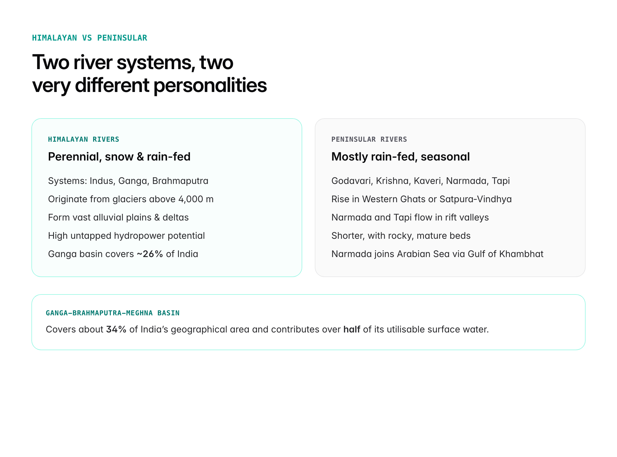
- Himalayan rivers (perennial, snow- and rain-fed): Indus, Ganga, Brahmaputra systems
- Peninsular rivers (mostly rain-fed, seasonal): Godavari, Krishna, Kaveri, Narmada, Tapi, Mahanadi
- Coastal rivers (short, west-flowing): Sharavati, Periyar, Kalinadi
- Inland drainage rivers: Ghaggar, Luni
Significance of Large Rivers
- Agriculture: The Ganga-Yamuna basin alone feeds a very large share of India's food production.
- Hydropower: The Himalayan system has the highest untapped hydro potential.
- Navigation: National Waterway 1 (Ganga), 2 (Brahmaputra), 3 (West Coast Canal) and others
- Culture and tourism: Ganga, Narmada and Kaveri are deeply tied to religious life
- Biodiversity: River dolphins (Ganga in Ganga-Brahmaputra, Indus in Beas/Indus)
UPSC Relevance
Prelims focus
- Ganga: largest river in India by length within country
- Godavari: longest peninsular river, "Dakshin Ganga"
- Sources, tributaries and states traversed
- Rivers flowing into Arabian Sea vs Bay of Bengal
- Rift valley rivers: Narmada and Tapi
Mains GS-I angle
- Important geophysical features; rivers and settlement patterns
- Inter-state river water disputes (Cauvery, Krishna, Mahadayi)
Mains GS-III angle
- River interlinking, Namami Gange, environmental challenges
Sample PYQ-style question
"Discuss the contrasting features of Himalayan and peninsular river systems in India with reference to their hydrological behaviour and economic importance." (GS-I, 15 marks)