The Gangotri Glacier is one of the largest glaciers in the Indian Himalaya and the hydrological source of the Bhagirathi, which becomes the Ganga at Devprayag. Located in Uttarakhand’s Uttarkashi district, it stretches over 30 km through the Garhwal Himalaya. Its snout, the iconic Gaumukh (“cow’s mouth”), is both a geographic landmark and a sacred site — pilgrims consider Gaumukh the mythological origin of the Ganga. For UPSC candidates, the Gangotri sits at the intersection of physical geography, Himalayan hydrology, climate change, disaster management, and cultural geography. Its documented retreat is one of the most-cited data points in Indian climate science.
Location and Extent
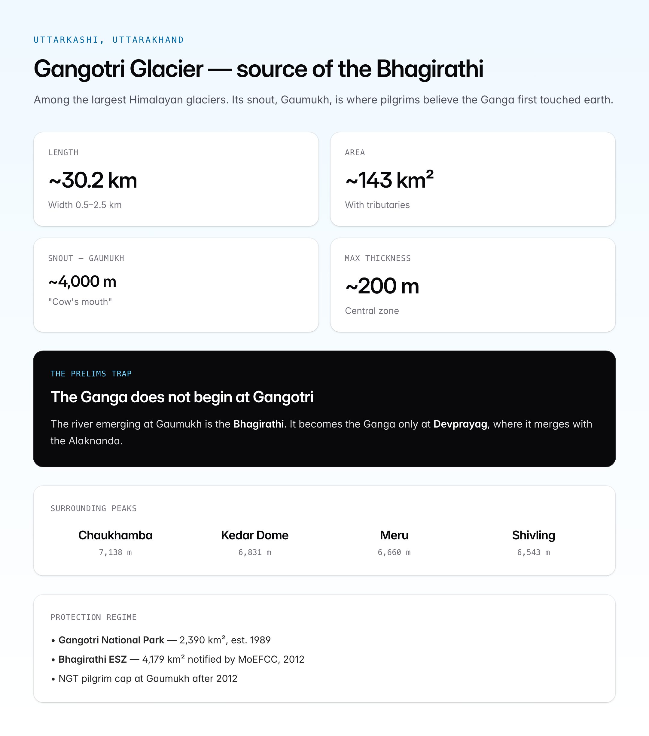
The Gangotri Glacier system lies in the Greater Himalayan zone of Uttarkashi district, within the Bhagirathi basin.
| Parameter | Detail |
|---|---|
| State / District | Uttarakhand / Uttarkashi |
| Mountain range | Greater Himalaya (Garhwal) |
| Length | ~30.2 km (main glacier) |
| Width | 0.5 to 2.5 km |
| Area (with tributaries) | ~143 sq km |
| Thickness (max) | Up to ~200 m in central zone |
| Snout elevation (Gaumukh) | ~4,000 m (has shifted upward over decades) |
| Head elevation | ~7,000 m (Chaukhamba massif vicinity) |
| Orientation | Flows NW to SE |
The glacier's head region is surrounded by the Chaukhamba (7,138 m), Kedar Dome (6,831 m), Meru (6,660 m), and Shivling (6,543 m) peaks.
Tributary Glaciers
Several major tributary glaciers feed the Gangotri system.
| Tributary glacier | Joining point | Notes |
|---|---|---|
| Raktvarn | Upper Gangotri | Large N tributary |
| Chaturangi | Below Meru | Multi-lobed tributary |
| Kirti | Near Bhojbasa | Flows from Kirti peaks |
| Ghanohim | Upper glacier | Small tributary |
| Swachand | Middle glacier | Feeds from western flank |
| Meru | Below Meru peak | From Meru massif |
The Gangotri Group as a whole includes roughly 18 major glaciers draining into the main trunk.
Gaumukh — The Snout
The snout of the Gangotri is called Gaumukh or "cow's mouth," because the ice cave from which the Bhagirathi emerges is said to resemble a cow's mouth.
- Approximately 18 km trek from Gangotri town through the Gangotri National Park
- Traditional sacred status: the mythological point where the Ganga descends to earth (Gangavatarana)
- Restricted zone: only a fixed number of pilgrims and trekkers allowed per day after 2012 NGT order
- Permit required from Forest Department, Gangotri National Park
Above Gaumukh lies Tapovan (~4,460 m), a high-altitude meadow with a long Hindu ascetic tradition; further beyond is Nandanvan (~4,400 m), the base camp for expeditions to Bhagirathi and Shivling.
Geological and Glaciological Setting
The glacier flows through a deep U-shaped valley carved into granitic and gneissic bedrock. Key features:
- Central medial moraines — dark stripes along the ice surface, marking confluences with tributaries
- Lateral moraines — high ridges on valley walls, recording past ice levels
- Terminal moraine at older snout positions
- Crevasse fields in steeper sections
- Debris-covered ablation zone in the lower glacier — slows melt locally but hides mass loss
Gangotri is classified as a temperate/sub-polar valley glacier — characteristic of most major Himalayan glaciers.
Hydrology — From Glacier to Ganga
The water emerging at Gaumukh is the Bhagirathi. Its journey to becoming the Ganga:
| Stage | Location | Elevation |
|---|---|---|
| Origin | Gaumukh, Gangotri Glacier | ~4,000 m |
| Gangotri town | Uttarkashi district | ~3,100 m |
| Harsil | Uttarkashi | ~2,620 m |
| Uttarkashi | District HQ | ~1,158 m |
| Tehri Dam reservoir | Tehri district | ~830 m |
| Devprayag | Confluence with Alaknanda | ~475 m |
| Ganga begins | Below Devprayag | — |
Annual discharge at Gaumukh is estimated at 1–2 cubic km of water, varying seasonally. The glacier contributes roughly 25% of Bhagirathi flow during the pre-monsoon and monsoon, and a higher proportion during lean seasons.
Religious and Cultural Significance
Few natural features in India carry the cultural weight of Gangotri.
| Site | Significance |
|---|---|
| Gangotri town | One of the Chota Char Dham (Yamunotri, Gangotri, Kedarnath, Badrinath); Ganga temple rebuilt by Amar Singh Thapa (Gorkha general, early 19th century) |
| Gaumukh | Physical source of the Ganga; sacred |
| Tapovan, Nandanvan | Sites of Hindu ascetic tradition |
| Bhagirath Shila | Rock at Gangotri where King Bhagirath meditated to bring Ganga to earth |
The mythological story of Bhagiratha — his penance to bring the celestial Ganga to earth to liberate his ancestors — is central to both the river's name (Bhagirathi) and the site's religious identity.
Glacier Retreat — Climate Change Data
The Gangotri is one of the most closely monitored glaciers in India. Scientific measurements of its retreat began in the 19th century and are continuous since the mid-20th century.
Retreat Rates by Period
| Period | Mean annual retreat |
|---|---|
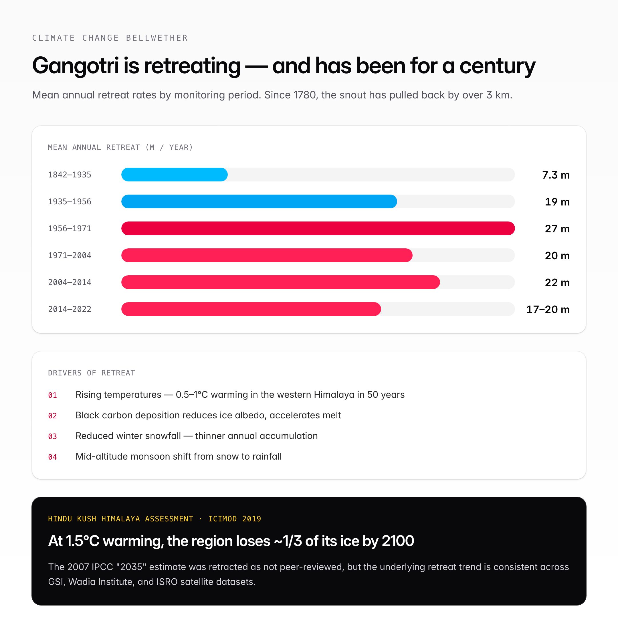
| 1842–1935 | ~7.3 m/year |
| 1935–1956 | ~19 m/year |
| 1956–1971 | ~27 m/year |
| 1971–2004 | ~20 m/year |
| 2004–2014 | ~22 m/year |
| 2014–2022 (estimates) | ~17–20 m/year |
Since 1780, the Gangotri has retreated by over 3 km. Total documented retreat since the mid-19th century: around 2 km.
Monitoring Agencies
- Geological Survey of India (GSI) — historical glaciological surveys
- Wadia Institute of Himalayan Geology (WIHG), Dehradun — detailed monitoring since 1970s
- National Institute of Hydrology, Roorkee
- Indian Space Research Organisation (ISRO) — satellite remote sensing, SAC Ahmedabad
- MoEFCC — National Mission for Sustaining the Himalayan Ecosystem (NMSHE)
Causes of Retreat
| Driver | Effect |
|---|---|
| Rising temperatures | Nearly 0.5–1°C warming in western Himalaya over the last 50 years |
| Black carbon deposition | Soot from biomass and diesel reduces albedo, accelerates melt |
| Reduced winter snowfall | Thinner annual accumulation |
| Changing monsoon pattern | Shift from snow to rainfall at mid-altitudes |
| Debris cover dynamics | Can locally slow or accelerate melt |
IPCC and the Infamous "2035" Error
The IPCC Fourth Assessment Report (2007) mentioned that Himalayan glaciers could disappear by 2035 — a figure later retracted as having been drawn from non-peer-reviewed sources. While exaggerated, the core concern remains valid: most Himalayan glaciers, including the Gangotri, are in sustained retreat, and the Hindu Kush Himalaya is warming faster than the global average.
The Hindu Kush Himalaya Assessment (ICIMOD, 2019) projects that even at 1.5°C global warming, the region will lose about one-third of its ice by 2100.
Protection Status
The glacier and its surrounds are protected under multiple regimes.
| Regime | Detail |
|---|---|
| Gangotri National Park | Established 1989; 2,390 sq km |
| Eco-Sensitive Zone | Around 4,179 sq km notified by MoEFCC (2012) under EPA 1986 |
| Bhagirathi ESZ | Strict restrictions on mining, large construction, hydropower in glacier catchment |
| NGT orders | Pilgrim cap at Gaumukh; restrictions on plastic and open defecation |
The Bhagirathi ESZ notification is one of the most stringent ecological zones in India and has been used as a template for other glacier-fed catchments.
UNESCO Context
The Gangotri is not inscribed as a UNESCO World Heritage Site in its own right, but:
- The neighbouring Nanda Devi and Valley of Flowers National Parks (1988, 2005) are UNESCO inscribed — part of the same western Himalayan landscape
- UNESCO's Man and the Biosphere (MAB) programme covers glacial ecosystems through the Nanda Devi Biosphere Reserve
- The IUCN Outlook Report (2020) lists the Gangotri system as "significant concern" under climate change
India has proposed cryosphere monitoring under multiple international frameworks including the UNFCCC and UNESCO IHP (International Hydrological Programme).
Hydropower Controversy
Several hydropower projects on the Bhagirathi have faced strong opposition because of their position downstream of the glacier:
- Tehri Dam (operational, 2,400 MW)
- Loharinag-Pala (cancelled, 2010)
- Pala Maneri (scrapped)
- Bhaironghati (scrapped)
In 2010, the government declared a 130 km stretch from Gaumukh to Uttarkashi as an Eco-Sensitive Zone, scrapping three major projects after public campaigns led by G.D. Agarwal (Swami Gyan Swaroop Sanand).
UPSC Relevance
Gangotri Glacier is a high-value topic across multiple GS papers.
- Prelims: Location in Uttarakhand/Uttarkashi, snout (Gaumukh), length (~30 km), source of Bhagirathi (not Ganga directly — Ganga begins at Devprayag), Char Dham Gangotri, Gangotri National Park (1989), Bhagirathi ESZ (2012)
- Mains GS Paper I (Geography): Himalayan glaciers, Ganga drainage system, Panch Prayag sequence, Bhagirathi-Alaknanda-Ganga, U-shaped glacial valleys
- Mains GS Paper III (Environment): Glacier retreat data, Hindu Kush Himalaya Assessment (ICIMOD 2019), climate change impact on cryosphere, black carbon, National Mission for Sustaining the Himalayan Ecosystem (NMSHE — one of eight missions under the National Action Plan on Climate Change)
- Mains GS Paper III (Disaster Management): GLOFs, 2013 Uttarakhand floods, 2021 Chamoli glacier burst, 2023 Sikkim Teesta GLOF
- Current affairs: G.D. Agarwal (Swami Sanand) movement, Char Dham Pariyojana, hydropower decisions, Joshimath land subsidence (adjacent region)
- Prelims trap: Ganga does not begin at Gangotri — the river emerging at Gaumukh is the Bhagirathi, which becomes the Ganga only at Devprayag where it merges with the Alaknanda.
Candidates should master: the distinction between Bhagirathi and Ganga, the Panch Prayag sequence, the historical retreat timeline, the ESZ framework, and the link between Himalayan cryosphere loss and the broader climate change syllabus.
Tell Google you want more of this.
Add Anantam IAS as a preferred sourceOne tap, and this site shows up more often in your own Top Stories, AI Overviews and AI Mode. Remove it any time.