Mandakini River — Source, Course and Religious Significance
Mandakini River Uttarakhand: origin at Chorabari glacier, tributary of Alaknanda, Kedarnath, 2013 floods and course through Rudraprayag.
The Mandakini is a short but important Himalayan river in Uttarakhand — a major tributary of the Alaknanda, itself a headstream of the Ganga. Rising from the Chorabari Glacier just above Kedarnath, the Mandakini flows for about 72 kilometres before joining the Alaknanda at Rudraprayag. Though small in length, the river holds immense religious weight (it is central to the Chota Char Dham and Panch Prayag circuits) and ecological consequence — the devastating 2013 Kedarnath floods originated from a cloudburst and glacial lake outburst above its source.
Origin — The Chorabari Glacier
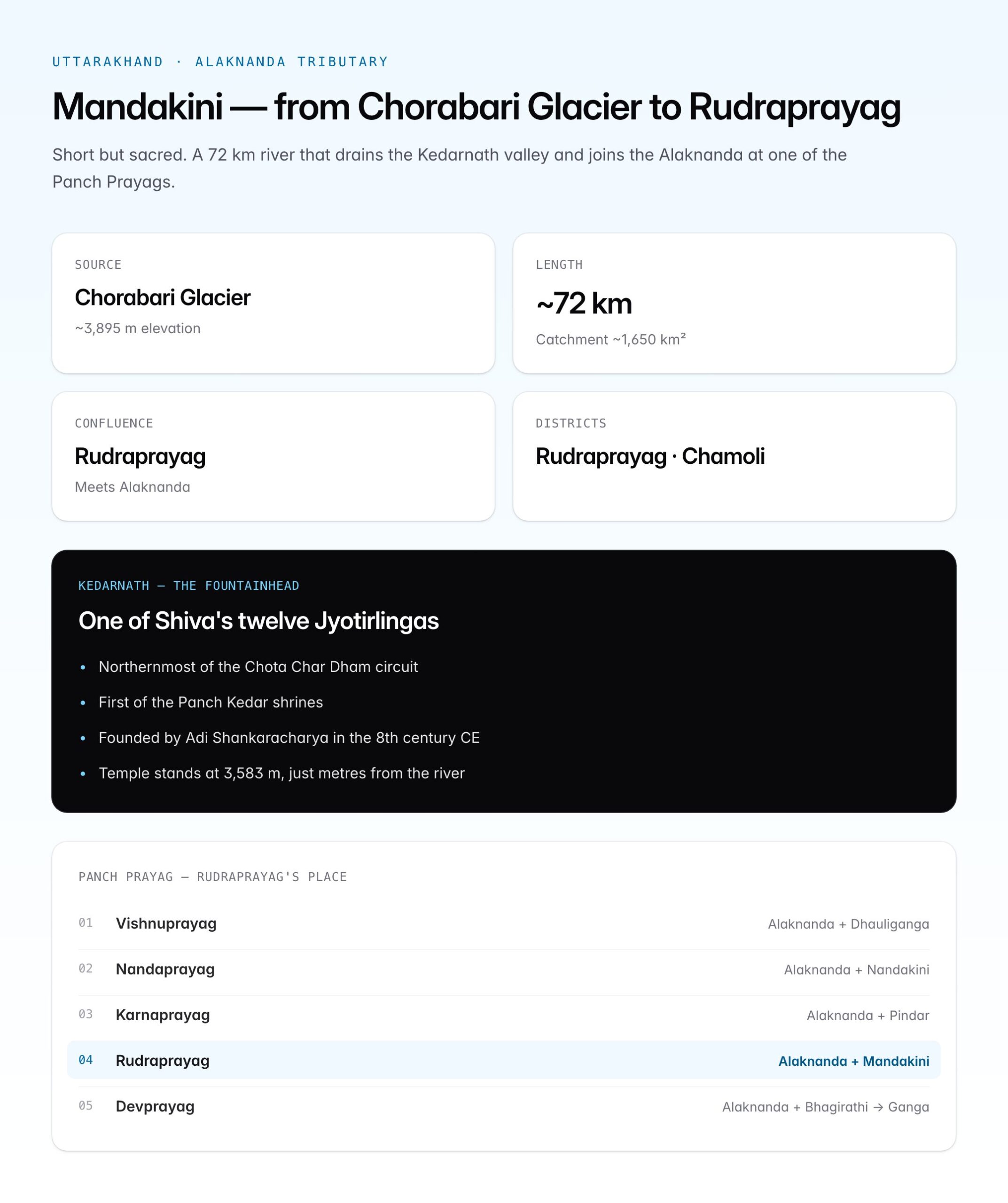
The Mandakini rises on the southern slopes of the Chorabari Bamak (glacier) at around 3,895 m elevation, just beyond the Kedarnath temple.
| Parameter | Detail |
|---|---|
| Source | Chorabari Glacier, Uttarakhand |
| Elevation of source | ~3,895 m above sea level |
| State | Uttarakhand (Rudraprayag, Chamoli districts) |
| Length | ~72 km |
| Outfall | Alaknanda, at Rudraprayag |
| Catchment area | ~1,650 sq km |
| Mean discharge | ~100–150 m³/s (variable) |
Chorabari Tal — a small glacial lake also called Gandhi Sarovar (Gandhi's ashes were immersed here in 1948) — sits adjacent to the glacier snout. The lake played a catastrophic role in the 2013 disaster.
Course of the River
The Mandakini flows in a generally southerly to south-easterly direction, cutting deep gorges through the Greater Himalaya and emerging into the Lesser Himalaya before joining the Alaknanda.
| Reach | Location |
|---|---|
| Source to Kedarnath | Glacial meltwater zone |
| Kedarnath to Gaurikund | Through temple town; joined by Saraswati and Vasuki Ganga |
| Gaurikund to Sonprayag | Steep gorge; joined by Son Ganga at Sonprayag |
| Sonprayag to Guptkashi | Narrow valley; small settlements |
| Guptkashi to Ukhimath | Widening valley; orchards, agriculture |
| Ukhimath to Agastyamuni | Lesser Himalayan zone |
| Agastyamuni to Rudraprayag | Confluence zone with Alaknanda |
Tributaries
Though a tributary itself, the Mandakini has several tributaries of its own.
| Tributary | Joining point | Notes |
|---|---|---|
| Saraswati | Just below Kedarnath | Tiny stream; considered sacred |
| Vasuki Ganga | Below Kedarnath | Flows from Vasuki Tal |
| Son Ganga | Sonprayag | Drains the valley from Kedarnath; name "Son" = gold |
| Madhyamaheshwar Ganga | Near Ukhimath | Drains the Madhyamaheshwar temple area |
| Kali Ganga | Agastyamuni | Tributary from the east |
Prayags on the Mandakini Route
Uttarakhand's rivers are defined by their prayags — ritual confluences. The Mandakini system has two.
| Prayag | Confluence |
|---|---|
| Sonprayag | Mandakini + Son Ganga |
| Rudraprayag | Mandakini + Alaknanda |
Rudraprayag is one of the Panch Prayags (Five Confluences) that traditionally form the Ganga's headwater sequence — Vishnuprayag, Nandaprayag, Karnaprayag, Rudraprayag, Devprayag. At Devprayag, the Alaknanda meets the Bhagirathi and becomes the Ganga.
| Panch Prayag | Confluence |
|---|---|
| Vishnuprayag | Alaknanda + Dhauliganga |
| Nandaprayag | Alaknanda + Nandakini |
| Karnaprayag | Alaknanda + Pindar |
| Rudraprayag | Alaknanda + Mandakini |
| Devprayag | Alaknanda + Bhagirathi → Ganga begins |
Religious Significance — Kedarnath and Beyond
The Mandakini is inseparable from the sacred geography of Garhwal. Temples and pilgrim routes trace its course.
Kedarnath — The Fountainhead
Kedarnath is:
- One of the twelve Jyotirlingas of Lord Shiva
- The northern-most of the Char Dham Yatra (Yamunotri–Gangotri–Kedarnath–Badrinath)
- One of the Panch Kedar (Kedarnath, Madhyamaheshwar, Tungnath, Rudranath, Kalpeshwar)
- Traditionally founded by Adi Shankaracharya (8th century CE)
The temple stands at 3,583 m just metres from the Mandakini's upper course.
Other Sacred Sites Along the Mandakini
| Site | Significance |
|---|---|
| Gaurikund | Starting point of Kedarnath trek; hot springs sacred to Parvati |
| Sonprayag | Second prayag on the route; vehicles reach up to this point |
| Triyuginarayan | Temple said to mark site of Shiva–Parvati wedding |
| Guptkashi | "Hidden Kashi"; Vishwanath temple |
| Ukhimath | Winter seat of Kedarnath deity |
| Madhyamaheshwar | Second of the Panch Kedar |
| Agastyamuni | Named after sage Agastya |
| Rudraprayag | Confluence with Alaknanda; Rudranath temple |
Mythology
In Hindu tradition, Mandakini is also one of the names of the celestial Ganga flowing in Swarga (heaven). The earthly Mandakini, flowing past Kedarnath, is considered a terrestrial projection of this heavenly river.
The 2013 Uttarakhand Floods
On 16–17 June 2013, the Mandakini valley witnessed one of independent India's worst natural disasters. The event is inseparable from any discussion of the river.
Sequence of Events
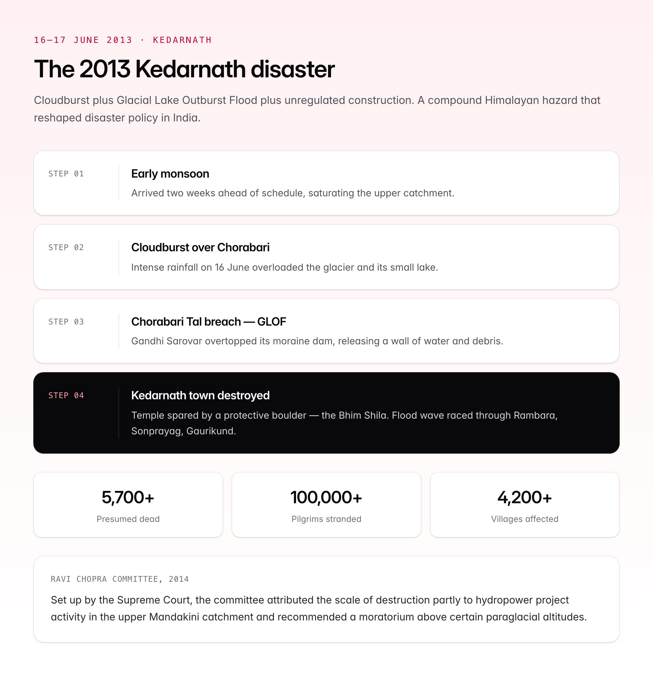
- Early monsoon arrived ~two weeks ahead of schedule
- Intense cloudburst over Chorabari and surrounding slopes on 16 June
- Chorabari Tal (Gandhi Sarovar) overflowed and breached its moraine dam — a Glacial Lake Outburst Flood (GLOF)
- Massive debris and water surged down the Mandakini valley
- Kedarnath town was devastated; temple survived (famously spared by a protective boulder — Bhim Shila)
- Wave of flood water raced through Rambara, Sonprayag, Gaurikund, Guptkashi, reaching Rudraprayag
- Alaknanda, itself swollen, propagated destruction further downstream
Scale of Damage
| Indicator | Figure |
|---|---|
| Official deaths | 5,700+ (presumed dead after rescue) |
| Pilgrims stranded | Over 100,000 |
| Villages affected | 4,200+ |
| Houses destroyed | 2,500+ |
| Roads washed out | ~2,500 km of state and national highways |
| Bridges lost | Over 200 |
| Rescue operation | Operation Surya Hope — Army, IAF, ITBP, NDRF (world's largest civilian rescue at the time) |
Contributing Factors
The disaster was compounded by human choices:
- Unregulated construction on the floodplain and riverbanks
- Hydroelectric dams (NTPC Tapovan, Vishnuprayag) altering channel dynamics
- Deforestation in the catchment
- Ribbon settlement along pilgrim routes
- Early monsoon interacting with glacier-fed flow
- Weak early warning systems
The Ravi Chopra Committee (2014) set up by the Supreme Court attributed the scale of destruction partly to hydropower project activities in the upper catchments.
Hydropower and Environmental Concerns
The Mandakini basin hosts several small and medium hydropower projects — proposed, under construction, and operational. Most controversial include:
- Singoli-Bhatwari HEP (99 MW)
- Phata Byung HEP (76 MW)
- Vishnuprayag and Tapovan on the neighbouring Alaknanda system
Post-2013, several projects were reviewed or shelved under Supreme Court direction. The Chopra Committee recommended a moratorium on new projects above certain altitude thresholds in paraglacial zones — a recommendation only partly implemented.
Ecology
The Mandakini valley passes through distinct ecological zones:
| Elevation | Vegetation |
|---|---|
| >3,500 m | Alpine meadow (bugyal), bare rock |
| 2,500–3,500 m | Fir, spruce, birch |
| 1,800–2,500 m | Mixed oak, pine, rhododendron |
| Below 1,800 m | Chir pine, sal, cultivation terraces |
Fauna includes Himalayan monal (state bird of Uttarakhand), musk deer, snow leopard (high zones), Himalayan black bear, and langur. Parts of the catchment fall within Kedarnath Wildlife Sanctuary (975 sq km).
UPSC Relevance
The Mandakini is a high-frequency Geography and disaster-management topic.
- Prelims: Origin at Chorabari Glacier, tributary of Alaknanda, confluence with Alaknanda at Rudraprayag, Panch Prayag sequence, Kedarnath as a Jyotirlinga and Char Dham site, 2013 Uttarakhand floods
- Mains GS Paper I (Geography): Himalayan drainage, river confluences of Uttarakhand, Alaknanda-Bhagirathi-Ganga origin
- Mains GS Paper III (Disaster Management): 2013 floods as a case study, GLOF (Glacial Lake Outburst Flood) risks, cascade effects of cloudburst + hydropower + unregulated construction
- Mains GS Paper III (Environment): Paraglacial hazards, hydropower in the Himalayas, Ravi Chopra Committee recommendations, Char Dham road project debates
- Linkages: 2013 Kedarnath → 2021 Chamoli (Rishi Ganga) flood → 2023 Sikkim (Teesta) GLOF — a growing Himalayan disaster pattern
- Current affairs: Char Dham all-weather road, Kedarnath reconstruction, Glacier Lake monitoring by ISRO
Candidates should remember: the Mandakini is relatively short but sits at the heart of India’s sacred geography, its hydrology is tightly coupled with climate change, and its 2013 disaster is the single most cited example of a GLOF-cloudburst-development compound hazard in Indian Himalayan literature.