Narmada River — Origin, Course, Tributaries, and UPSC Notes
Narmada River rises at Amarkantak, flows west through a rift valley across MP, Maharashtra, and Gujarat. Complete UPSC guide with map, tributaries, and dams.
The Narmada River, also spelt Narbada or Rewa, is the largest west-flowing river of peninsular India and the fifth-longest river in India. Rising at Amarkantak in the Maikal range of Madhya Pradesh, it flows through Madhya Pradesh, Maharashtra, and Gujarat before emptying into the Gulf of Khambhat (Gulf of Cambay) in the Arabian Sea. Its path through a rift valley between the Vindhya and Satpura ranges, its sacred status in Hindu tradition, and its association with the Sardar Sarovar Dam make it a high-priority UPSC topic that cuts across physical geography, resource geography, environment, and social movements.
Narmada at a Glance
| Feature | Detail |
|---|---|
| Source | Amarkantak Plateau, Maikal Range, Anuppur district, Madhya Pradesh |
| Elevation of source | About 1,057 metres |
| Length | About 1,312 km |
| Drainage basin | About 98,796 sq km |
| States traversed | Madhya Pradesh (~1,077 km), Maharashtra (~74 km), Gujarat (~161 km); also forms part of MP–Maharashtra and Maharashtra–Gujarat boundaries |
| Direction of flow | Mostly east to west |
| Outfall | Gulf of Khambhat, Arabian Sea |
| Geological setting | Rift valley between Vindhya Range (north) and Satpura Range (south) |
| Major dam | Sardar Sarovar Dam (Gujarat) |
| Other major dams | Indira Sagar, Omkareshwar, Maheshwar, Bargi |
| Sacred status | One of the seven holy rivers of India |
Origin at Amarkantak
The Narmada rises from a tank (Narmada Kund) at the Amarkantak Plateau in the Maikal range, 1,057 m above sea level, in Anuppur district of Madhya Pradesh. Amarkantak is also the source region of the Son and the Mahanadi, making it a tri-junction of important rivers. The Narmada descends through the Kapildhara Falls and the Dugdhdhara Falls near its source.
Course of the Narmada
The river's journey can be divided into upper, middle, and lower reaches.
Upper Course (Amarkantak to Jabalpur)
From Amarkantak the Narmada flows westward through the upper Satpura plateau. Near Jabalpur, it passes through the famous Marble Rocks at Bhedaghat, plunging over the Dhuandhar Falls ("smoke cascade"). Here the river is narrow, swift, and flanked by sheer white marble cliffs, a popular tourist and geological site.
Middle Course (Jabalpur to Maheshwar)
Downstream of Jabalpur the river enters the Narmada Valley proper, a rift valley bounded by the Vindhya Range to the north and the Satpura Range to the south. This rift valley is one of India's most distinctive physical features, formed by block faulting. The Narmada flows through Jabalpur, Narsimhapur, Hoshangabad (Narmadapuram), Harda, Khandwa, and Khargone. Important dams and towns along this reach include:
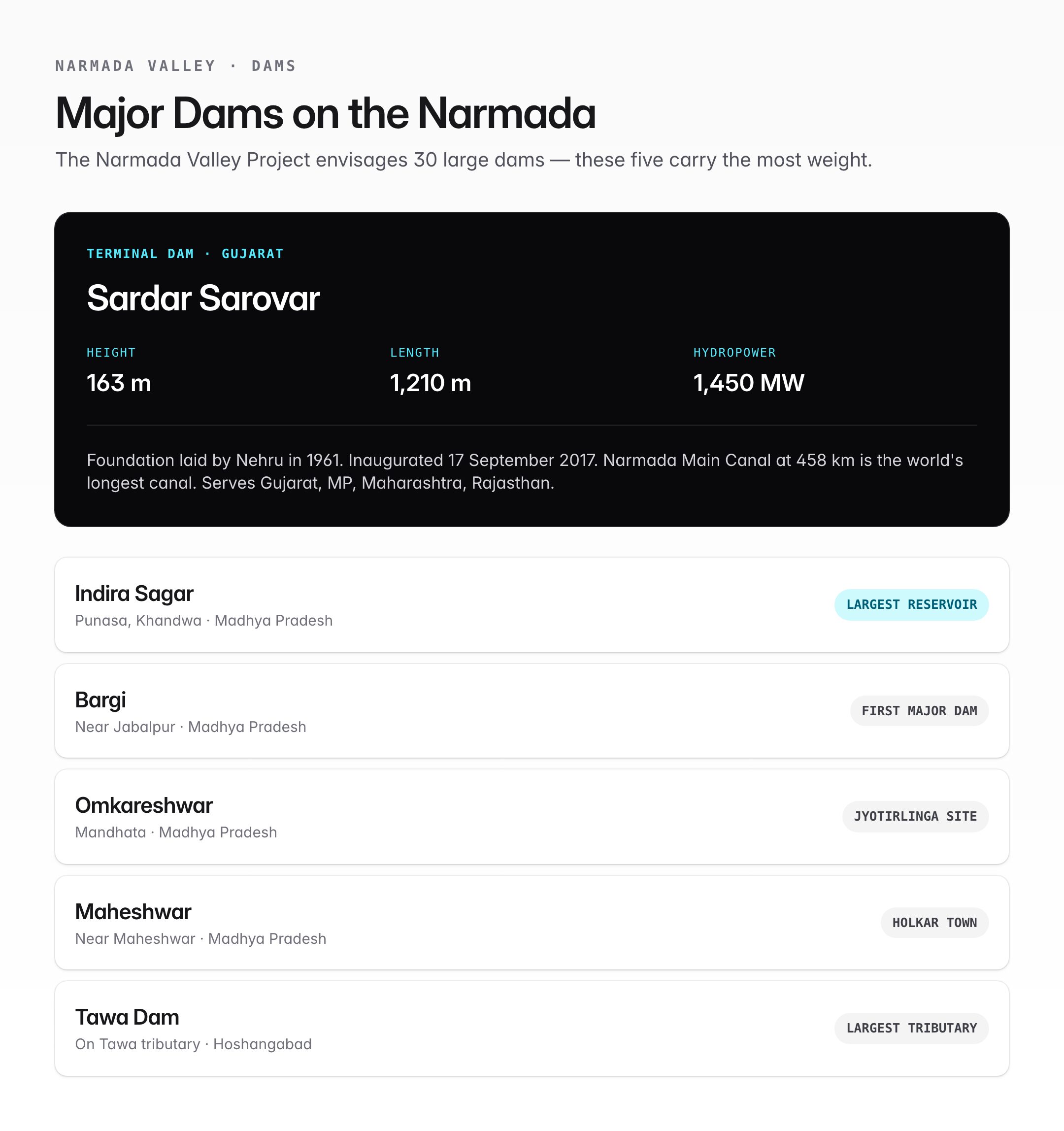
- Bargi Dam — first major storage dam, near Jabalpur.
- Indira Sagar Dam — at Punasa in Khandwa district; the largest reservoir by volume on the Narmada.
- Omkareshwar Dam — near Mandhata, which hosts one of the twelve Jyotirlingas.
- Maheshwar Dam — near the historic town of Maheshwar associated with Ahilyabai Holkar.
Lower Course (Maheshwar to Arabian Sea)
Past Maheshwar, the Narmada enters Maharashtra for a short stretch, briefly forming the boundary between Madhya Pradesh and Maharashtra, and then between Maharashtra and Gujarat. It cuts across the Sardar Sarovar Dam at Navagam in Gujarat, then crosses the fertile alluvial plain of Bharuch and discharges into the Gulf of Khambhat. The estuary is broad and funnel-shaped, creating a significant tidal influence in the lower reaches near Bharuch.
Why the Narmada Flows West
Most peninsular rivers (Godavari, Krishna, Kaveri, Mahanadi) flow east to the Bay of Bengal because the peninsular plateau slopes eastward. The Narmada and its sister Tapi are exceptions — they flow west because they occupy rift valleys created by block faulting between the Vindhya–Satpura and Satpura–Ajanta ranges. These faults are old geological features. The rift structure also explains why the Narmada does not form a large delta; its lower course is compressed between the ranges before it reaches the sea through a narrow coastal plain.
Tributaries of the Narmada
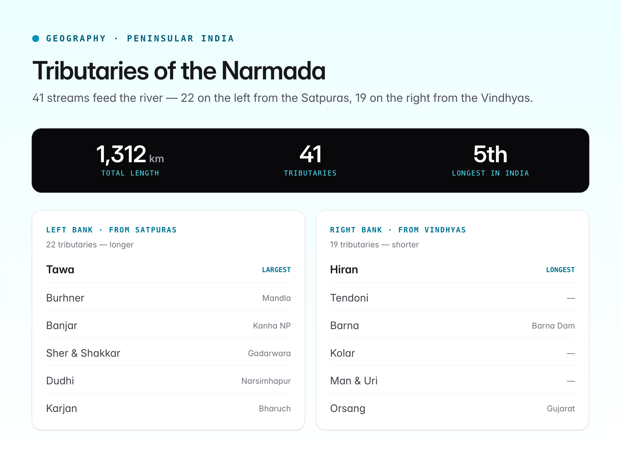
The Narmada has about 41 tributaries, of which 22 are on the left bank and 19 on the right bank.
Major Left-Bank Tributaries (longer; rise in Satpura)
| Tributary | Confluence near | Note |
|---|---|---|
| Burhner | Mandla | Joins in upper course |
| Banjar | Mandla | Flows through Kanha National Park |
| Sher | Gadarwara | – |
| Shakkar | Gadarwara | – |
| Dudhi | Narsimhapur | – |
| Tawa | Near Hoshangabad | Largest tributary; hosts Tawa Dam |
| Ganjal | – | – |
| Chhota Tawa | – | – |
| Kundi | – | – |
| Goi | – | – |
| Karjan | Bharuch district | Joins in lower course |
Major Right-Bank Tributaries (shorter; rise in Vindhya)
| Tributary | Note |
|---|---|
| Hiran | Flows through Katni–Jabalpur region |
| Tendoni | – |
| Barna | Hosts Barna Dam |
| Kolar | – |
| Man | – |
| Uri | – |
| Hatni | – |
| Orsang | Joins in Gujarat |
The Tawa is the most important tributary by discharge and catchment; the Hiran is the longest right-bank tributary.
Narmada Valley Project and Sardar Sarovar Dam
The Narmada Valley Development Project is one of the largest integrated multi-purpose river-valley schemes in the world. It envisages 30 large dams, 135 medium dams, and over 3,000 small dams on the Narmada and its tributaries.
Sardar Sarovar Dam
The Sardar Sarovar Dam is the largest dam on the Narmada and the terminal dam of the project.
| Feature | Detail |
|---|---|
| Location | Navagam, Gujarat |
| Type | Concrete gravity |
| Height | 163 m |
| Length | ~1,210 m |
| Foundation laid | 1961 (Jawaharlal Nehru) |
| Inaugurated | 17 September 2017 |
| Installed hydropower | 1,450 MW (200 MW river-bed + 250 MW canal-head) with Gujarat and MP as beneficiaries |
| Main canal | Narmada Main Canal — longest canal in the world at ~458 km |
| Beneficiary states | Gujarat, Madhya Pradesh, Maharashtra, Rajasthan |
Other Major Dams
| Dam | State | River | Purpose |
|---|---|---|---|
| Bargi | MP | Narmada | Irrigation, power |
| Indira Sagar | MP | Narmada | Multi-purpose; largest reservoir by volume |
| Omkareshwar | MP | Narmada | Power, irrigation |
| Maheshwar | MP | Narmada | Power |
| Tawa | MP | Tawa tributary | Irrigation |
| Bargi | MP | Narmada | Irrigation |
Narmada Water Disputes Tribunal
The Narmada Water Disputes Tribunal (NWDT) was constituted in 1969 under the Inter-State River Water Disputes Act, 1956, involving Madhya Pradesh, Gujarat, Maharashtra, and Rajasthan. Its 1979 award fixed the annual utilisable flow at 28 MAF and allocated it among the four states, with Gujarat receiving 9 MAF, MP 18.25 MAF, Maharashtra 0.25 MAF, and Rajasthan 0.5 MAF. The award also set conditions for the Sardar Sarovar Dam height.
Narmada Bachao Andolan
The Narmada Bachao Andolan (NBA), led notably by Medha Patkar from the mid-1980s, opposed the Sardar Sarovar Dam's planned height citing displacement of tribal and rural communities, inadequate rehabilitation, submergence of forests and farmland, and ecological disruption. The Supreme Court's 2000 judgment allowed dam construction to continue with monitoring of rehabilitation. The movement remains a landmark case study in displacement, environmental justice, and participatory development.
Cultural and Religious Significance
- One of the seven holiest rivers of India (Ganga, Yamuna, Godavari, Saraswati, Narmada, Sindhu, Kaveri).
- The Narmada Parikrama is a sacred 2,600-km circumambulation of the river.
- Sacred sites include Amarkantak, Omkareshwar (Jyotirlinga), Maheshwar, Bhedaghat, and Bharuch.
- The Narmada is considered older and more sacred than the Ganga in some Puranic traditions.
Quick Revision Table
| Point | Fact |
|---|---|
| Origin | Amarkantak, Maikal Range, MP |
| Length | ~1,312 km (5th longest in India) |
| States | MP, Maharashtra, Gujarat |
| Falls into | Gulf of Khambhat, Arabian Sea |
| Flow direction | West (through rift valley) |
| Largest tributary | Tawa |
| Longest right tributary | Hiran |
| Largest dam | Sardar Sarovar (Gujarat) |
| Largest reservoir | Indira Sagar (MP) |
| Famous falls | Dhuandhar (Jabalpur) |
| Famous rocks | Marble Rocks, Bhedaghat |
| Inter-state tribunal | NWDT, 1969; award 1979 |
UPSC Relevance
The Narmada River is a recurring Prelims topic through questions on origin, tributaries, states traversed, and major dams. Aspirants must remember Amarkantak as the source, the rift valley between the Vindhyas and Satpuras, the Tawa as the largest tributary, and the Sardar Sarovar Dam as the terminal dam. For Mains GS Paper I (Geography), the Narmada illustrates river patterns of peninsular India, the role of fault lines in drainage, and the importance of multipurpose projects. In GS Paper II, it connects to inter-state river disputes, the federal politics of water, and the Inter-State River Water Disputes Act, 1956. In GS Paper III, the Narmada Valley Project is a textbook example of environment versus development trade-offs, with the Narmada Bachao Andolan, the Supreme Court's 2000 judgment, and Environmental Impact Assessment all on point. For Ethics (GS IV) and Essay, the Narmada story offers a rich illustration of distributive justice, displacement, rehabilitation policy, and the moral weight of ecological heritage in public decision-making.