

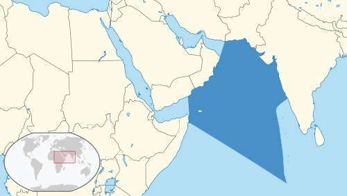
The Arabian Sea is the northwestern arm of the Indian Ocean, bordered by India’s western coast, the Arabian Peninsula, the Horn of Africa, and Pakistan/Iran. It is one of the most strategically and economically important water bodies in the world — carrying a significant share of global maritime trade, including oil shipments from the Persian Gulf.
For UPSC, the Arabian Sea appears in Physical Geography (GS1), Maritime Security (GS3), and International Relations (Indian Ocean geopolitics).
Location and Extent
| Feature | Details |
|---|---|
| Area | Approximately 3.86 million sq km |
| Maximum depth | ~4,652 m (Murray Ridge area) |
| Bordered by | India (east), Pakistan and Iran (north), Oman and Yemen (west), Somalia and Horn of Africa (southwest) |
| Connected to | Persian/Arabian Gulf (via Strait of Hormuz), Gulf of Aden (via Gulf of Oman), Red Sea (via Bab-el-Mandeb) |
| Part of | Indian Ocean (northwestern section) |
Indian coastline on the Arabian Sea: India's western coast — from Gujarat in the north to Kerala in the south — faces the Arabian Sea. States/UTs with Arabian Sea coastline: Gujarat, Maharashtra, Goa, Karnataka, Kerala, and the UT of Lakshadweep.
Key Geographical Features
Islands
| Island Group | Country | Key Facts |
|---|---|---|
| Lakshadweep | India | 36 islands (10 inhabited); coral atolls; India's smallest UT |
| Socotra | Yemen | Biodiversity hotspot; UNESCO Heritage; "Galapagos of the Indian Ocean" |
UPSC distinction: Lakshadweep (Arabian Sea, coral islands) vs. Andaman & Nicobar (Bay of Bengal, volcanic/tectonic islands). This is a frequently tested difference.
Gulfs and Straits
| Feature | Location | Significance |
|---|---|---|
| Gulf of Kutch | Gujarat coast | Coral reefs; Marine National Park; Mundra and Kandla ports |
| Gulf of Khambhat | Gujarat coast | Narmada and Tapi rivers drain here; proposed Kalpasar tidal energy project |
| Strait of Hormuz | Between Oman and Iran | ~20% of world's oil passes through; most strategic chokepoint in the Arabian Sea region |
| Palk Strait | Between India and Sri Lanka | NOT Arabian Sea — it's on the eastern side (common trick question) |
Major Rivers Draining into the Arabian Sea
All rivers of India's western coast drain into the Arabian Sea:
- Narmada (Gujarat) — flows through a rift valley; one of only two major rivers flowing westward
- Tapi (Gujarat) — also flows westward through a rift valley
- Sabarmati (Gujarat)
- Mahi (Gujarat)
- Mandovi and Zuari (Goa)
- Sharavati (Karnataka) — Jog Falls
- Periyar (Kerala)
- Short, swift west-flowing rivers from the Western Ghats
UPSC point: The Narmada and Tapi are the only two major peninsular rivers that flow westward into the Arabian Sea (through rift valleys). All other major peninsular rivers (Godavari, Krishna, Kaveri, Mahanadi) flow eastward into the Bay of Bengal.
Role in the Monsoon
The Arabian Sea plays a critical role in the Indian monsoon system:
Arabian Sea branch of the Southwest Monsoon:
- Moisture-laden winds blow from the Arabian Sea toward India's western coast
- The Western Ghats force these winds to rise (orographic lifting), causing heavy rainfall on the windward (western) side
- This branch brings rain to Kerala, Karnataka coast, Goa, Konkan (Maharashtra), and Gujarat
- The onset of the monsoon (typically June 1) first hits Kerala from the Arabian Sea
Arabian Sea vs. Bay of Bengal monsoon branches:
| Feature | Arabian Sea Branch | Bay of Bengal Branch |
|---|---|---|
| Direction | Southwest → Northeast | Southeast → Northwest |
| First impact | Kerala, Western Ghats | Andaman & Nicobar, Northeast India |
| Rainfall pattern | Heavy on western coast; rain shadow on eastern Deccan | Heavy in Northeast, eastern coast, Indo-Gangetic Plain |
| Cyclone frequency | Lower (~2% of global tropical cyclones) | Higher (~7%) |
Arabian Sea cyclones: While less frequent than Bay of Bengal cyclones, Arabian Sea cyclones have been increasing in frequency and intensity in recent years — attributed to rising sea surface temperatures linked to climate change. Notable recent cyclones: Tauktae (2021), Biparjoy (2023).
Major Ports on the Arabian Sea
| Port | State | Significance |
|---|---|---|
| Mumbai (Nhava Sheva/JNPT) | Maharashtra | India's largest container port |
| Mundra | Gujarat | India's largest private port (Adani Group); largest port by cargo volume |
| Kandla (Deendayal) | Gujarat | Major government port; tidal port |
| Mormugao | Goa | Iron ore export; naval significance |
| New Mangalore | Karnataka | Iron ore, petroleum |
| Cochin | Kerala | Natural harbour; naval base; Vallarpadam container terminal |
Strategic and Economic Significance
Trade route: The Arabian Sea carries:
- Oil from the Persian Gulf to Asia, Europe, and Africa
- Container shipping between Asia and Europe (via the Suez Canal)
- Approximately 40% of the world's oil transits through the Arabian Sea region
Indian Navy: India's Western Naval Command (headquartered in Mumbai) is responsible for the Arabian Sea. India has significant naval presence including:
- INS Kadamba — naval base at Karwar, Karnataka (India's largest)
- Surveillance of sea lanes of communication (SLOCs)
- Anti-piracy operations (Gulf of Aden)
Lakshadweep's strategic value: The Lakshadweep islands extend India's Exclusive Economic Zone (EEZ) deep into the Arabian Sea, giving India maritime jurisdiction over a vast area.
China factor: China's development of Gwadar Port (Pakistan) on the Arabian Sea — as part of the Belt and Road Initiative's China-Pakistan Economic Corridor (CPEC) — is a strategic concern for India. Gwadar is seen as potentially having dual-use (commercial + military) capabilities.
UPSC Relevance
GS1 (Geography): Indian Ocean, monsoon mechanism, western coast, rivers.
GS2 (IR): Indian Ocean geopolitics, Strait of Hormuz, Indo-Pacific strategy.
GS3 (Security): Maritime security, naval strategy, port infrastructure.
Key Prelims facts:
- Location: Northwestern Indian Ocean
- Indian states on Arabian Sea: Gujarat, Maharashtra, Goa, Karnataka, Kerala + Lakshadweep
- Key island: Lakshadweep (coral atolls)
- Strait of Hormuz: ~20% of world's oil
- Westward-flowing rivers: Narmada and Tapi (rift valleys)
- Monsoon: Arabian Sea branch brings rain to western India
- Largest port by cargo: Mundra (Gujarat)
- India's Western Naval Command: Mumbai
- Gwadar Port: Pakistan (China-developed, CPEC)
Tell Google you want more of this.
Add Anantam IAS as a preferred sourceOne tap, and this site shows up more often in your own Top Stories, AI Overviews and AI Mode. Remove it any time.






