NavIC vs GPS vs Galileo vs BeiDou: India’s Position in the Global Satellite Navigation Race
A complete UPSC GS-III explainer comparing NavIC with GPS, Galileo, BeiDou, GLONASS, and QZSS. Covers constellation design, coverage, signal frequencies, accuracy, civil and strategic use, NVS satellites, India's L1 modernization, and why a sovereign GNSS matters.
Satellite navigation is one of those modern infrastructures that almost everyone uses and almost no one thinks about. A car looks for a route, a fishing boat finds its grid square, a soldier locates a checkpoint, an aircraft locks onto an approach to a runway, a power utility timestamps a fault. All of it depends on a small constellation of satellites broadcasting timing signals that a receiver translates into position to within a few metres.
For more than three decades, the dominant signal came from the United States Global Positioning System. GPS was opened to civilian use in the 1980s, became the global default for civil navigation, and is embedded in almost every smartphone, vehicle, and aircraft on the planet. The strategic implication, that civilian users in every country depend on a constellation owned and operated by the US Space Force, has driven each major space power to build its own. Russia kept GLONASS alive through the lean post-Soviet decade. The European Union built Galileo as a civilian-controlled system. China developed BeiDou into a global rival. Japan added a regional augmentation called QZSS. India built the Indian Regional Navigation Satellite System, IRNSS, now branded NavIC.
For UPSC purposes, NavIC and its global counterparts intersect space technology, the Indian Space Policy 2023, strategic autonomy, civil aviation, mobile-handset standards, and the wider question of how a country secures its critical infrastructure. This article walks through each system, compares them on the dimensions that matter, and explains where India fits in the global satellite navigation order.
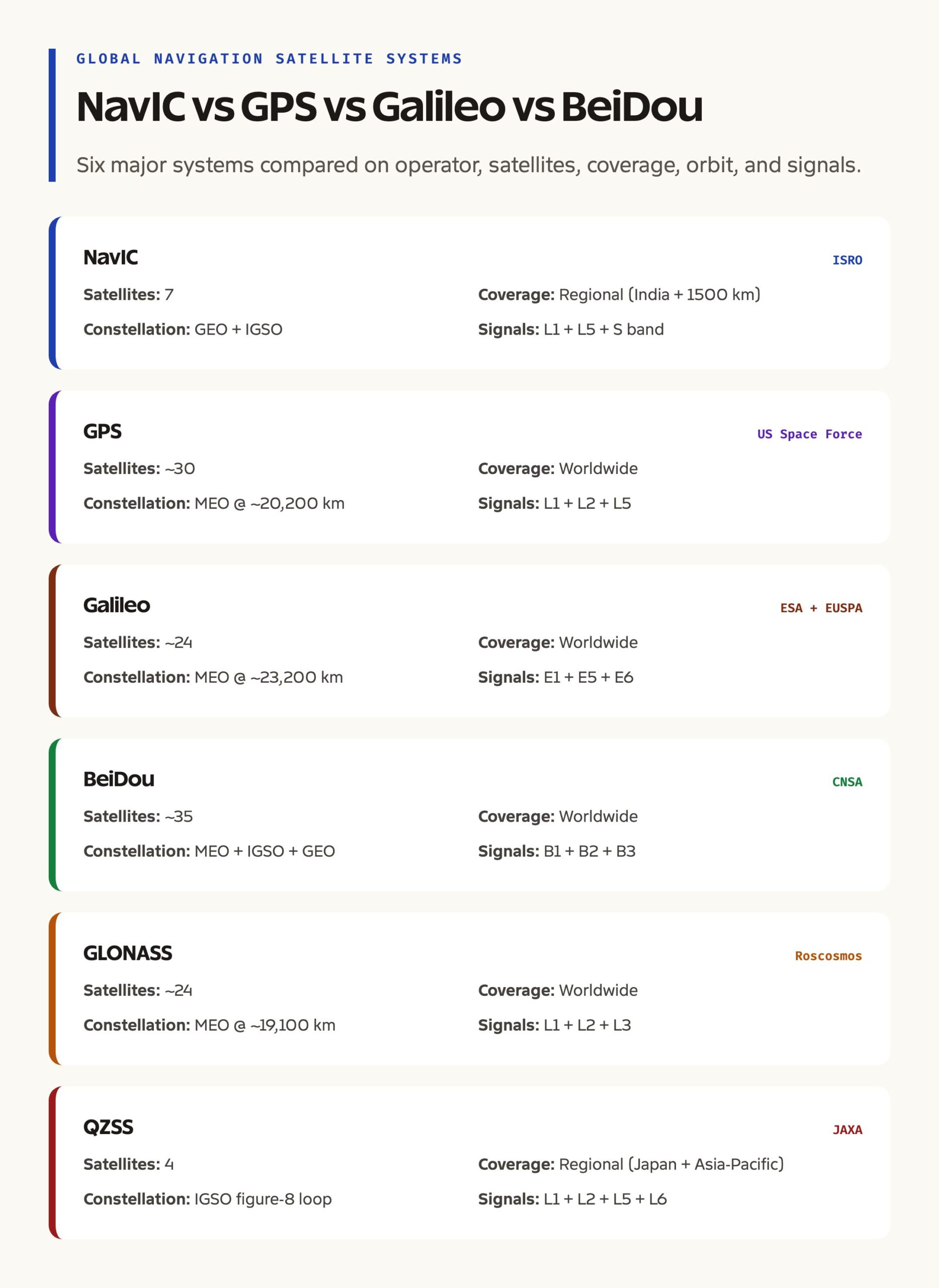
Quick Facts on the Major GNSS Systems
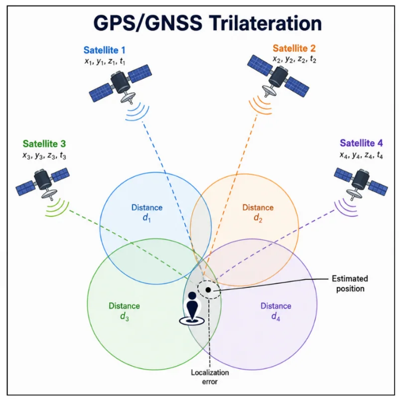
A Global Navigation Satellite System, GNSS, is a constellation of satellites that broadcast precise timing signals from known orbital positions. A receiver picks up signals from at least four satellites, measures the small differences in arrival time, and solves for its own three-dimensional position and clock offset. Position accuracy depends on signal frequency, atmospheric conditions, receiver quality, and the geometry of the satellites visible at any moment.
GPS, the US Global Positioning System, is operated by the US Space Force and is the oldest fully operational global GNSS. It uses a constellation of about 30 satellites in medium Earth orbit at roughly 20,200 kilometres altitude. It provides civilian and military signals on multiple L-band frequencies, with the modernised L1C, L2C, and L5 signals offering improved accuracy and resilience.
Galileo is the European Union’s civilian GNSS, jointly managed by the European Space Agency and the EU Agency for the Space Programme. The constellation uses about 24 to 30 satellites in medium Earth orbit at about 23,200 kilometres. Galileo is unique among the major systems for being civilian-controlled from the outset, although it offers a Public Regulated Service for government use. Full operational capability was declared in 2017.
BeiDou is China’s GNSS, managed by the China National Space Administration. The third-generation BDS-3 constellation, completed in 2020, uses about 35 satellites distributed across medium Earth orbit, inclined geosynchronous orbit, and geostationary orbit. The mixed orbital architecture gives BeiDou strong regional coverage over Asia and global coverage on lower-latitude orbits.
GLONASS is the Russian system, managed by Roscosmos. It uses about 24 satellites in medium Earth orbit at roughly 19,100 kilometres. GLONASS operations were rescued in the 2000s after the post-Soviet decline.
QZSS, the Japanese Quasi-Zenith Satellite System, is a regional augmentation operated by JAXA. Its four satellites move in highly inclined orbits that trace a figure-eight loop concentrated over Japan and the surrounding Asia-Pacific region.
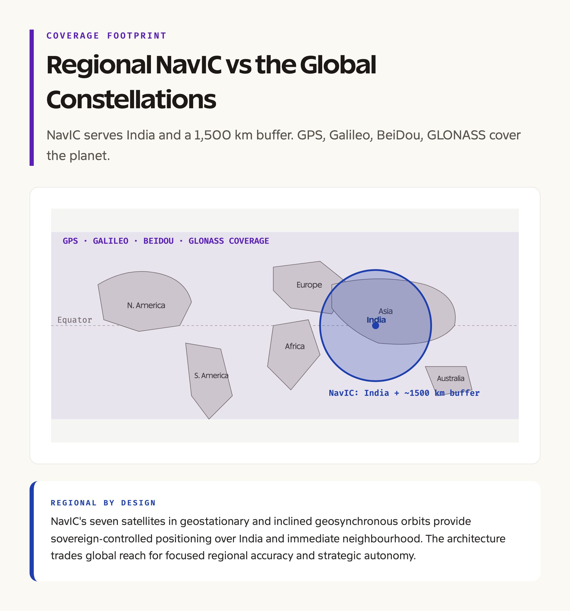
NavIC, India’s Navigation with Indian Constellation, is operated by the Indian Space Research Organisation. The original IRNSS constellation comprises seven satellites, three in geostationary orbit and four in inclined geosynchronous orbit. NavIC provides regional coverage over India and a buffer extending about 1,500 kilometres beyond the country’s borders.
What NavIC Actually Is
NavIC is a regional system. It does not aim to provide global coverage. It is designed to serve India and its neighbourhood with sovereign-controlled positioning, navigation, and timing.
The constellation uses three satellites in geostationary orbit at 32.5 East, 83 East, and 131.5 East, and four satellites in inclined geosynchronous orbit. The geostationary satellites maintain fixed longitudes; the inclined geosynchronous satellites trace a daily figure-eight pattern over the equator. The combination provides good visibility over the Indian region with relatively few satellites.
NavIC offers two broadcast services. The Standard Positioning Service, SPS, is for civilian use. The Restricted Service, RS, is encrypted and intended for authorised government and military users. Signals are transmitted on the L5 and S bands, with NavIC’s modernised second-generation NVS satellites adding the L1 band, which is compatible with mass-market smartphone chipsets.
The system was designed to be independent of any other country’s infrastructure. The historical trigger is the much-cited episode during the Kargil conflict in 1999, when India is reported to have been denied access to GPS-quality signals over the affected region. Whatever the precise details, the strategic case for sovereign navigation became politically firm after that and through the 2000s.
Background and Historical Context
The Indian Regional Navigation Satellite System programme was approved by the Government of India in 2006, with a target of seven satellites and an investment of around 1,420 crore rupees. ISRO selected a regional architecture with a mix of geostationary and inclined geosynchronous orbits, partly to economise on the launches needed and partly because the inclined geosynchronous orbits give better visibility at India’s latitudes than a pure geostationary constellation.
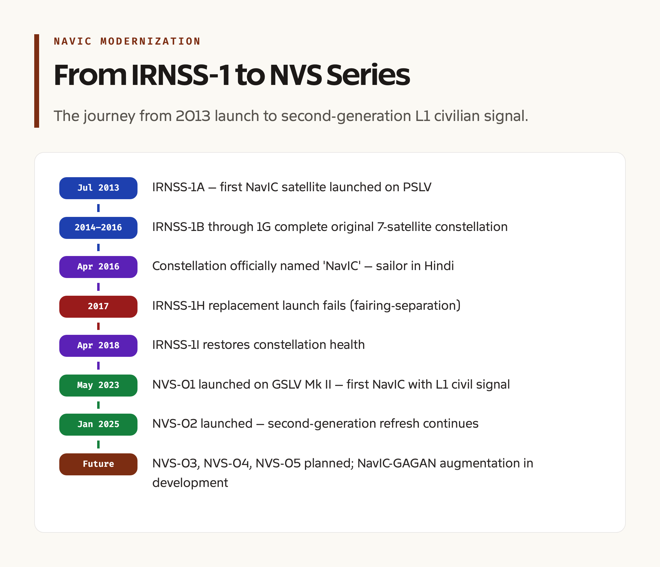
The first IRNSS-1A satellite launched in July 2013 on a Polar Satellite Launch Vehicle, PSLV. Subsequent launches followed at six- to twelve-month intervals, with IRNSS-1G completing the original constellation in April 2016. The system was officially named NavIC by Prime Minister Narendra Modi at that point, both as an acronym and as a Hindi word meaning sailor or navigator.
The first generation of NavIC faced two problems. The atomic clocks on IRNSS-1A failed shortly after launch, and replacements were needed for several other satellites in the original constellation. ISRO launched IRNSS-1H in 2017 as a backup, but the launch failed due to a fairing-separation issue. IRNSS-1I, launched in April 2018, restored full constellation health.
The second-generation NavIC programme, also called NVS, began launching in 2023. NVS-01 lifted off on a GSLV Mk II in May 2023, becoming the first NavIC satellite with an L1 civil signal that mass-market smartphone chipsets can pick up. NVS-02 launched in January 2025 to continue the constellation refresh. Three further NVS satellites are planned. The full second-generation series will eventually replace the original IRNSS-1 family and will give NavIC the L1, L5, and S-band signals needed for broad civilian and government use.
Key Features of Each Major System
GPS uses 24 to 32 active satellites in six orbital planes inclined at 55 degrees, at roughly 20,200 kilometres altitude. The modernised constellation broadcasts on L1, L2, and L5 frequencies. Civilian accuracy is in the few-metre range without augmentation, and sub-metre with differential corrections. The constellation is operated by the US Space Force from a master control station at Schriever Space Force Base in Colorado.
Galileo uses 24 satellites plus active spares in three orbital planes, also at medium Earth orbit. It broadcasts on E1, E5, and E6 frequencies. Galileo’s Open Service offers civilian accuracy comparable to GPS, and its High-Accuracy Service provides sub-metre accuracy without ground augmentation, which is unique among the major systems. The Public Regulated Service is encrypted and reserved for European government use.
BeiDou’s BDS-3 broadcasts on B1, B2, and B3 frequencies. The mixed orbital architecture, with geostationary, inclined geosynchronous, and medium Earth orbit components, gives BeiDou strong coverage over China, Southeast Asia, and the Indian Ocean. BeiDou also provides a short-message service that is unique among the major GNSS systems and that has been used in fishing fleets and disaster scenarios.
GLONASS broadcasts on L1, L2, and L3 frequencies using a frequency-division access scheme that differs from the code-division access used by GPS, Galileo, and BeiDou. GLONASS’s smaller number of operational satellites and the geometry of its constellation make it particularly useful at high latitudes, where Russia has its core territorial interest.
QZSS provides a regional service over Japan with the unique property that its highly inclined orbit places at least one satellite near the local zenith, the point directly overhead, at all times. This is useful in urban canyons where low-elevation GPS satellites are blocked by tall buildings. QZSS supplements rather than replaces GPS in receivers that support both.
NavIC’s seven satellites broadcast on L5 and S bands, with NVS-01 onwards adding L1. Civilian accuracy is in the few-metre range over the Indian region. Receivers in handsets, vehicles, and survey equipment increasingly support NavIC alongside GPS, Galileo, and BeiDou through multi-constellation chipsets.
Why a Sovereign GNSS Matters
The first reason is strategic. A country whose military, transport, energy, and communication systems depend on a foreign-controlled timing signal is exposed to its disruption in a crisis. The signal can be denied, degraded, or selectively jammed. Sovereign GNSS removes that exposure for the territory the system is designed to cover.
The second is economic. GNSS underpins logistics, civil aviation, railway signalling, precision agriculture, surveying, mapping, and timing in financial markets. The cumulative economic value of accurate positioning runs into multiple percentage points of GDP for a developed economy. A country with its own system captures the policy levers, the standard-setting role, and the spillover into industry.
The third is signal-design freedom. Designing a GNSS lets a country choose frequencies, modulations, and authentication features that suit its specific use cases. NavIC’s S-band signal, for example, complements its L5 signal and gives more options for ionosphere correction at low elevations than a single-frequency system would.
The fourth is space-industrial capability. Building, launching, and operating a GNSS forces a country to develop atomic clocks, signal generators, ground stations, and receiver chipsets. Each of these is a high-value technology with civil and military applications beyond navigation.
Detailed Analysis: Coverage, Accuracy, and Receiver Ecosystem
GPS, Galileo, BeiDou, and GLONASS are global systems. Their constellations cover the entire surface of the Earth with at least the four satellites needed for a position fix, with redundancy almost everywhere. NavIC and QZSS are regional. They cover their primary region with high availability and degrade quickly outside it.
For everyday civilian use within India, modern multi-constellation receivers combine signals from GPS, Galileo, BeiDou, NavIC, and sometimes GLONASS into a single position estimate. Combining four or five systems produces accuracy that is markedly better than any single system alone, particularly in urban environments where buildings block low-elevation satellites.
For aviation, the major safety-of-life applications use GPS combined with the Indian GAGAN augmentation system and increasingly with NavIC. GAGAN is the GPS Aided Geo Augmented Navigation system jointly developed by ISRO and the Airports Authority of India, certified for civil-aviation use over India and parts of Southeast Asia. GAGAN provides differential corrections and integrity warnings that bring GPS-based navigation up to the standards required for instrument approaches at airports.
For mobile handsets, NavIC support has been the focus of policy since the late 2010s. The L5 signal that NavIC originally used was not common in mass-market chipsets. The newer L1 signal on NVS satellites is in the same band as GPS’s L1 and is supported by almost all modern smartphone chipsets. The Government of India has notified phased requirements for NavIC support in handsets sold in the country, with full L1 support expected to become standard in the coming years.
For surveying, agriculture, and precision applications, multi-constellation, multi-frequency receivers offer centimetre-level accuracy with appropriate processing. NavIC’s role in this segment is growing as the second-generation constellation is built out.
Comparative View at a Glance
GPS is the oldest, most ubiquitous, and most deeply embedded GNSS, with a strong civilian and military lineage. Galileo offers civilian control, high-accuracy services, and authentication features that make it attractive for European and allied users. BeiDou is the fastest-growing system, with strong regional coverage over China and a unique short-message service. GLONASS provides high-latitude coverage and Russian autonomy. QZSS augments GPS over Japan with high-elevation visibility. NavIC provides sovereign coverage over India and the immediate neighbourhood.
The number of satellites varies. GPS has about 30, BeiDou about 35, Galileo and GLONASS about 24, QZSS just 4, NavIC 7. Orbit altitudes also vary. Medium Earth orbit at roughly 20,000 kilometres is standard for GPS, Galileo, GLONASS, and parts of BeiDou. NavIC’s geostationary and inclined geosynchronous orbits sit at about 36,000 kilometres. QZSS uses high-inclination figure-eight orbits centred on Japan.
A user does not have to choose. A modern receiver supports several systems simultaneously and benefits from the geometric diversity of the combined signals.
Challenges and the Road Ahead
NavIC faces three principal challenges. The first is constellation refresh. The original IRNSS-1 satellites are reaching end-of-life and need to be replaced by the NVS series. The second is signal adoption. The L5 signal originally chosen for NavIC was not widely supported in mass-market chipsets; the migration to L1 helps, but it depends on the next generation of NVS satellites and on chipset vendors enabling NavIC L1 by default. The third is augmentation and integrity. NavIC needs to be paired with augmentation services like a NavIC version of GAGAN to be usable for safety-of-life applications.
Globally, all GNSS operators face similar challenges. Spectrum management is becoming difficult as terrestrial wireless networks press for more bandwidth. Jamming and spoofing of GNSS signals by hostile actors are increasingly common, and authentication features are now being added to civilian signals. Constellation modernisation is ongoing across all the major systems.
Prelims Pointers
NavIC is the operational name of the Indian Regional Navigation Satellite System, IRNSS. It comprises seven satellites, three in geostationary orbit and four in inclined geosynchronous orbit. Coverage is regional, India plus a buffer of about 1,500 kilometres. Signals are on L5 and S bands, with NVS-01 onwards adding L1. NavIC is operated by ISRO. GPS is operated by the US Space Force. Galileo is operated jointly by the European Space Agency and the EU Agency for the Space Programme. BeiDou is operated by the China National Space Administration. GLONASS is operated by Roscosmos. QZSS is a regional system operated by JAXA. The first NavIC satellite, IRNSS-1A, launched in July 2013. The first second-generation satellite, NVS-01, launched in May 2023. NVS-02 launched in January 2025.
Mains Practice Questions
- Discuss the strategic and economic rationale for India’s investment in a sovereign satellite navigation system. Compare NavIC with GPS, Galileo, and BeiDou on the dimensions that matter. (250 words)
- The transition from the original IRNSS constellation to the NVS series and the introduction of the L1 civilian signal mark a generational change in NavIC. Examine the technical and policy choices behind this transition. (250 words)
- Critical infrastructure in India increasingly relies on satellite-based positioning, navigation, and timing services. Assess the risks of dependence on foreign-controlled signals and the steps India is taking to mitigate them. (250 words)
Way Forward
The immediate priority is completing the NVS programme. The second-generation NavIC satellites with L1, L5, and S-band signals must be deployed at sufficient numbers to provide service continuity as the original IRNSS-1 satellites retire. Two NVS satellites are flying as of 2025; three more are planned over the next several years.
Building chipset and receiver support is the second priority. The notification regime for handsets sold in India, the encouragement of NavIC support in automotive infotainment, fleet management, and IoT devices, and the international standards work at the International Telecommunication Union and 3GPP to recognise NavIC as a peer GNSS are all ongoing tasks.
Augmentation services need to be expanded. A NavIC version of GAGAN, with integrity messaging and differential corrections, would unlock safety-of-life applications in aviation, rail, and maritime sectors. The Indian Regional Augmentation Service framework being developed by ISRO, the Airports Authority of India, and the Directorate General of Civil Aviation is the right vehicle.
Finally, India should plan for the next phase. Whether NavIC eventually expands to a global GNSS, whether it continues as a regional system with progressively richer signals, or whether it integrates more deeply with friendly partner systems like Galileo, are open questions that will shape Indian space and strategic policy through the next decade. The Indian Space Policy 2023 and the wider ISRO mission roadmap provide the framework. The implementation now matters.
Frequently Asked Questions
What is NavIC?
NavIC, short for Navigation with Indian Constellation, is India’s regional satellite navigation system, operated by ISRO. It comprises seven satellites, three in geostationary orbit and four in inclined geosynchronous orbit, providing positioning, navigation, and timing services over India and a buffer extending about 1,500 kilometres beyond the country’s borders.
How is NavIC different from GPS?
GPS is a global system operated by the US Space Force with about 30 satellites in medium Earth orbit, providing positioning anywhere on Earth. NavIC is a regional system with 7 satellites, providing service over India and the immediate neighbourhood. NavIC was built so that India could have sovereign control of positioning over its own territory.
What is the difference between NavIC L5 and NavIC L1 signals?
The original IRNSS satellites broadcast on the L5 and S bands. The L5 signal is precise but is not supported by most mass-market smartphone chipsets. NavIC’s second-generation NVS satellites, beginning with NVS-01 in 2023, add an L1 signal in the same band as GPS L1, which is supported by almost all modern smartphone chipsets and makes mass-market NavIC use possible.
Who manages each of the major GNSS systems?
GPS is managed by the US Space Force. Galileo is managed jointly by the European Space Agency and the EU Agency for the Space Programme. BeiDou is managed by the China National Space Administration. GLONASS is managed by Roscosmos. QZSS is managed by JAXA. NavIC is managed by ISRO.
Is NavIC accurate enough for civilian navigation?
Yes. Civilian NavIC accuracy is in the few-metre range over the Indian region, comparable to single-frequency GPS. Multi-constellation receivers that combine NavIC with GPS, Galileo, and BeiDou achieve better accuracy than any single system alone. For sub-metre and centimetre-level applications, augmentation systems and dual-frequency receivers are required.
What is GAGAN?
GAGAN is the GPS Aided Geo Augmented Navigation system, jointly developed by ISRO and the Airports Authority of India. It provides differential corrections and integrity warnings to GPS signals over India and parts of Southeast Asia, and is certified for safety-of-life civil-aviation use. A NavIC equivalent is in planning.
Why does India need its own GNSS when GPS is free?
GPS is free for civilian users but is operated by a foreign military, which retains the ability to degrade or deny the signal in a conflict scenario over a particular region. A sovereign GNSS removes that exposure for the territory the system is designed to cover, supports specialised national applications, and builds domestic capability in atomic clocks, signal design, and receiver chipsets.
What are NVS-01 and NVS-02?
NVS-01 is the first second-generation NavIC satellite, launched in May 2023 on a GSLV Mk II rocket. It introduced the L1 civilian signal alongside the existing L5 and S-band signals. NVS-02 followed in January 2025. Three further NVS satellites are planned to complete the constellation refresh.
Can a smartphone use NavIC and GPS together?
Yes. Modern multi-constellation chipsets in smartphones combine signals from NavIC, GPS, Galileo, BeiDou, and sometimes GLONASS into a single position estimate. The combined geometry produces better accuracy than any single system alone, particularly in urban environments. The Government of India has notified phased requirements for NavIC support in handsets sold in the country.
What is the unique short-message feature of BeiDou?
The BeiDou system, alone among the major GNSS systems, provides a satellite-based short-message service that allows users in remote areas without terrestrial communications to send brief text messages through the constellation. It has been used in Chinese fishing fleets and in disaster scenarios. The other systems provide only one-way navigation broadcasts.