Sutlej River: Source, Course, Tributaries, and Strategic Importance
Sutlej river explained: origin at Rakshastal, course through Himachal and Punjab, Bhakra dam, Indus Waters Treaty role, pollution, and UPSC-ready analysis.
The Sutlej river is the longest of the five tributaries of the Indus river system and the easternmost among the rivers allocated to India under the Indus Waters Treaty of 1960. Known in ancient Indian literature as the Shatadru, it rises on the Tibetan Plateau, pierces the Great Himalayas through a deep gorge, and flows across Himachal Pradesh and Punjab before joining the Chenab in Pakistan. The Sutlej underwrites the Bhakra Nangal complex, supports one of the world's most intensive canal systems, and sustains the agrarian economy of Indian Punjab. For UPSC, the Sutlej links physical geography, hydropower, federal water disputes, and India-Pakistan relations.
Origin and Naming
The Sutlej rises near Rakshastal (Rakas Tal) at an altitude of about 4,570 metres in Tibet, close to the sacred Mansarovar Lake and Mount Kailash.
- In Tibet it is called the Langqen Zangbo (Elephant River) because of the shape of its source gorge.
- In Sanskrit, it is the Shatadru ("hundred branches"), referenced in the Rigveda.
- Total length is approximately 1,450 kilometres, of which around 1,050 km lies in India and the remainder in China and Pakistan.
Course of the River
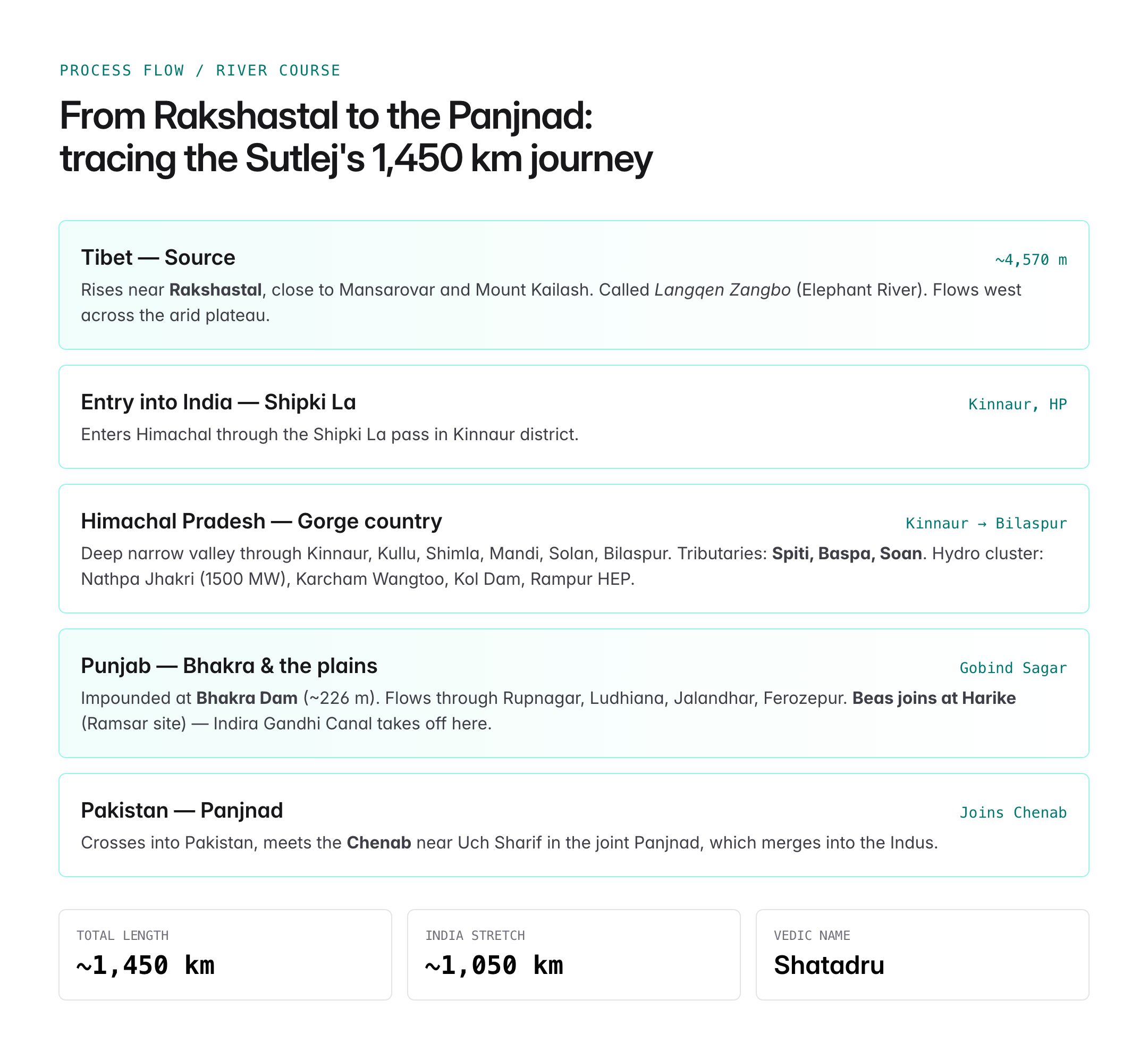
The Sutlej passes through three countries and multiple Indian states.

Oxford Student Atlas for India — 7th Edition
- 160 pages, Oxford University Press, the current edition
- India-focused thematic maps: physical, political, rivers, climate, soils, vegetation, plus world maps
- Made for UPSC and state PSC map work; slim enough to stay open beside the textbook
In Tibet
- Flows westwards from Rakshastal across the arid Tibetan plateau.
- Enters India through the Shipki La pass in Kinnaur district, Himachal Pradesh.
In Himachal Pradesh
- Cuts a deep, narrow valley through Kinnaur, Kullu, Shimla, Mandi, Solan, and Bilaspur.
- Major tributaries join in this stretch: Spiti, Baspa, and the Soan.
- Hosts a cluster of hydroelectric projects including Nathpa Jhakri (1500 MW), Karcham Wangtoo, Kol Dam, and Rampur HEP.
In Punjab
- Enters Punjab at Bhakra where the iconic Bhakra Dam impounds the Gobind Sagar reservoir.
- Flows through Rupnagar, Ludhiana, Jalandhar, and Ferozepur districts.
- The Beas joins the Sutlej at Harike in Tarn Taran district, from where the Indira Gandhi Canal takes off.
- Crosses into Pakistan and finally meets the Chenab near Uch Sharif, in the joint Panjnad which later joins the Indus.
Tributaries
| Tributary | Side | Notes |
|---|---|---|
| Spiti | Left | Rises in Spiti valley; joins near Khab |
| Baspa | Right | Famous for Sangla and Chitkul valleys |
| Soan | Left | Drains lower Shivaliks |
| Beas | Left | Joins at Harike Wetland; Ramsar site |
| Nogli Khad, Wanger | Minor | Himachal tributaries |
The Harike Wetland, a Ramsar site, marks the confluence of the Sutlej and Beas and is critical habitat for migratory birds.
Dams, Canals, and Hydropower
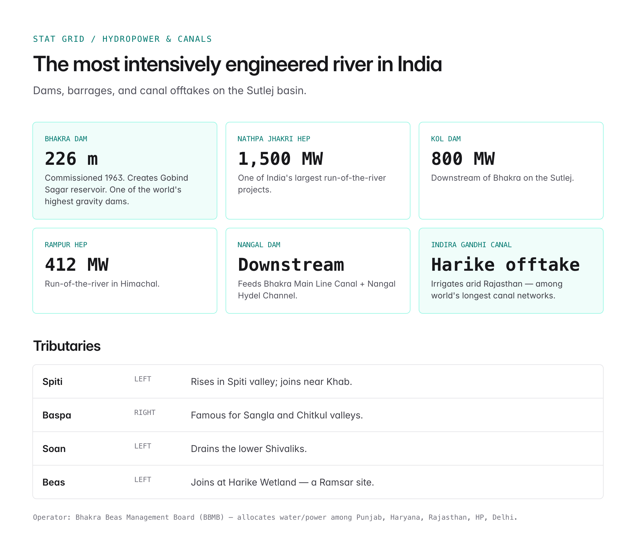
The Sutlej basin is one of India's most intensively engineered river systems.
- Bhakra Dam: Commissioned in 1963 on the Sutlej; one of the highest gravity dams in the world (~226 m). Creates Gobind Sagar, the reservoir.
- Nangal Dam: Downstream of Bhakra; supplies the Bhakra Main Line Canal and Nangal Hydel Channel.
- Kol Dam: Downstream, with a 800 MW hydropower installation.
- Nathpa Jhakri HEP: 1,500 MW, one of India's largest run-of-the-river projects.
- Rampur HEP: 412 MW run-of-the-river project.
- Indira Gandhi Canal (Rajasthan Canal): Takes water from the Sutlej-Beas waters at Harike to irrigate arid Rajasthan – one of the world's longest canal networks.
- Sirhind, Bist Doab, and Rajasthan Feeder canals: Form the backbone of Punjab, Haryana, and Rajasthan irrigation.
The Bhakra Beas Management Board (BBMB) manages water and power allocation among Punjab, Haryana, Rajasthan, Himachal Pradesh, and Delhi.
Indus Waters Treaty and the Sutlej
Under the Indus Waters Treaty of 1960, signed between India and Pakistan with the World Bank as a signatory:
- The Eastern Rivers – Sutlej, Beas, and Ravi – were allocated to India for unrestricted use.
- The Western Rivers – Indus, Jhelum, and Chenab – were allocated mainly to Pakistan, with limited Indian rights.
- Consequently, India is entitled to fully utilise the waters of the Sutlej, which has enabled projects like Bhakra and the Indira Gandhi Canal.
The Sutlej thus holds strategic weight: optimal use of its waters reduces dependence on the Western rivers and strengthens India's negotiating posture.
Ecological and Environmental Concerns
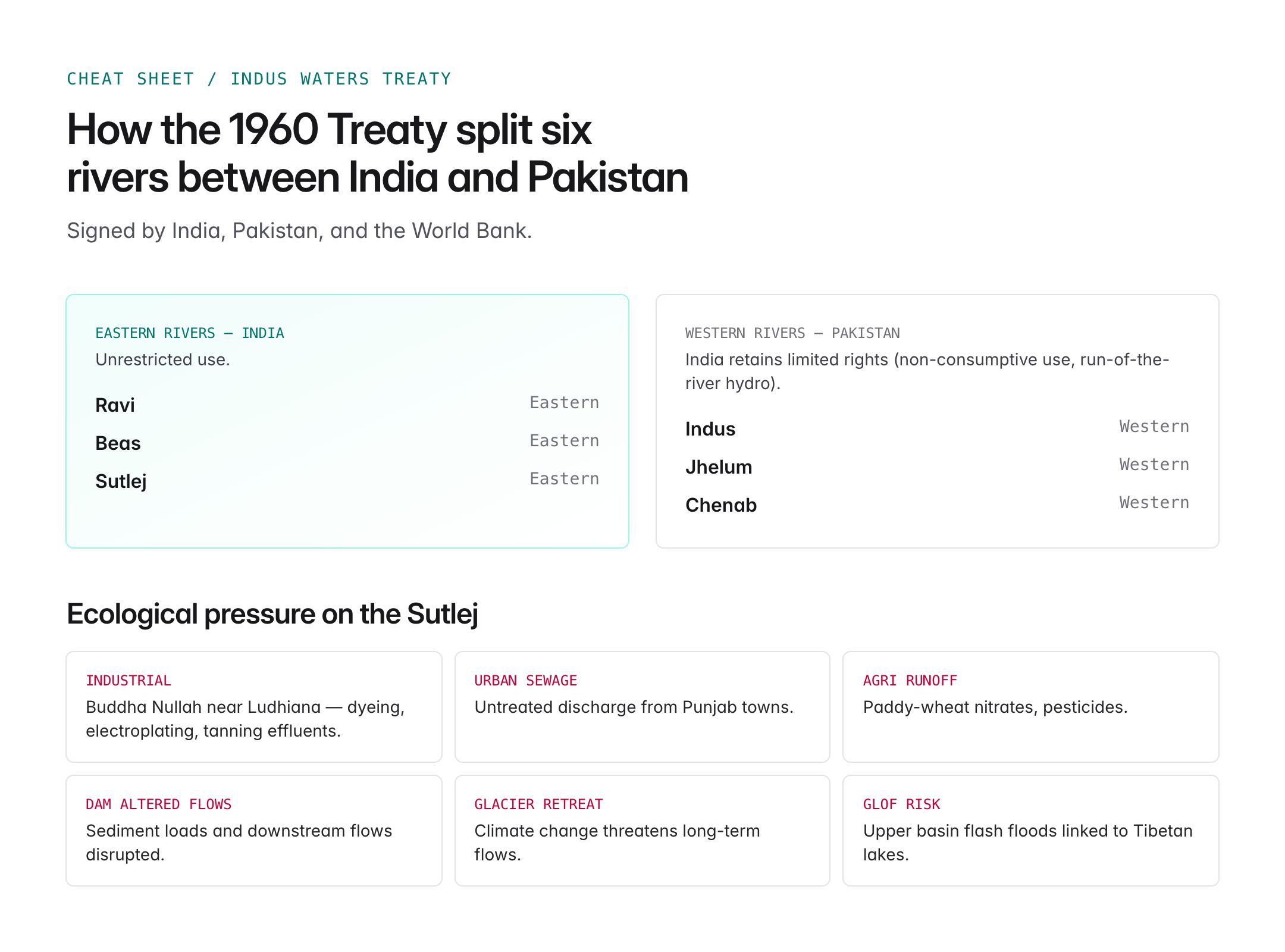
Despite its economic role, the Sutlej faces significant ecological stress.
- Industrial pollution: Stretches around Ludhiana receive untreated effluents from dyeing, electroplating, and tanning industries, particularly through the Buddha Nullah tributary.
- Urban sewage: Large volumes of untreated sewage enter the river from Punjab's towns.
- Agricultural runoff: Intensive paddy-wheat cultivation loads the river with nitrates and pesticides.
- Hydrological alteration: Extensive damming and canalisation have changed sediment loads and downstream flows.
- Glacier retreat: Climate change threatens long-term flows, especially for the high-altitude tributaries.
- Glacial Lake Outburst Flood (GLOF) risk: The upper Sutlej basin has witnessed flash flood events linked to debris flows and transient lakes in Tibet.
Programmes under the National River Conservation Plan and Punjab Pollution Control Board target sewage treatment and industrial compliance, though gaps remain.
Cultural and Historical Importance
- The Sutlej is one of the seven rivers of the Sapta Sindhu in Vedic geography.
- The Battle of Sutlej (1845-46) and Sobraon during the First Anglo-Sikh War took place along its banks.
- The river demarcated parts of the boundary between British India and the Sikh Empire before 1846.
- Towns such as Rupnagar (Ropar) on the Sutlej were Harappan sites, indicating ancient civilisational continuity.
UPSC Relevance
Prelims focus:
- Source of Sutlej at Rakshastal near Mansarovar; entry into India at Shipki La.
- Sutlej as the longest of the five eastern tributaries of the Indus system.
- Major tributaries: Spiti, Baspa, Beas and confluence at Harike (Ramsar site).
- Dams: Bhakra, Nangal, Kol; hydropower: Nathpa Jhakri, Rampur, Karcham Wangtoo.
- Indus Waters Treaty (1960) allocation of Eastern Rivers (Ravi, Beas, Sutlej) to India.
Mains GS-I and GS-II angles:
- Physical geography of the Himalayan river systems.
- River-water disputes under the BBMB and Sutlej-Yamuna Link (SYL) canal controversy.
- Indus Waters Treaty dynamics and India-Pakistan relations.
- Environmental degradation of Indian rivers and policy responses.
Sample PYQ angle: "Discuss the geophysical characteristics of the Ganga-Brahmaputra river system" or questions on the Indus Waters Treaty and inter-state water disputes. The Sutlej offers a concrete case – tying glacial origin, hydropower, canal irrigation, interstate allocation, and an international treaty into a single, exam-ready narrative.