Tapi River: Course, Ukai Dam & UPSC Geography Guide
Complete UPSC guide to the Tapi River — origin in Betul MP, west-flowing course, Ukai Dam, Surat delta, tributaries, and comparison with Narmada.
The Tapi River (also spelled Tapti) is one of only three major west-flowing rivers of peninsular India — alongside the Narmada and the Mahi. Rising in the Satpura Range of Madhya Pradesh, it flows westward through Maharashtra and Gujarat for 724 km before emptying into the Arabian Sea through the Gulf of Khambhat near Surat. Its basin — sandwiched between the Satpura and Ajanta/Satmala ranges — gives the Tapi the distinction of a rift-valley river, a rare geomorphology in peninsular India.
For UPSC, the Tapi is a core Geography (GS1) topic in Indian drainage systems, and appears frequently with the Narmada for comparative questions.
Key Facts
| Aspect | Detail |
|---|---|
| Alternative name | Tapti |
| Origin | Multai (Multapi), Betul district, Satpura Range, Madhya Pradesh |
| Elevation of source | ~752 m |
| Total length | ~724 km |
| States drained | Madhya Pradesh, Maharashtra, Gujarat |
| Outlet | Gulf of Khambhat (Cambay), Arabian Sea, near Surat |
| Flow direction | West-flowing (unusual for peninsular rivers) |
| Drainage basin | ~65,145 sq km |
| Position in basin size | 2nd largest west-flowing river basin in India after Narmada |
| Basin boundary (north) | Satpura Range |
| Basin boundary (south) | Satmala and Ajanta Ranges |
Why Is the Tapi West-Flowing?
Most peninsular rivers (Godavari, Krishna, Kaveri, Mahanadi) flow east into the Bay of Bengal because the peninsula tilts gently eastward. The Tapi and Narmada are exceptions.
| Reason | Explanation |
|---|---|
| Rift valley | The Tapi flows through a structural trough between Satpura (north) and Ajanta (south) |
| Faulted topography | Tectonic faulting created a west-sloping rift |
| Parallel to Narmada | Both rivers occupy grabens formed by Gondwana-era fracturing |
| No delta formation | Fast flow through narrow valley prevents delta; forms estuary at Surat |
This graben (rift valley) geomorphology explains several Tapi features: narrow valley, limited floodplain, heavy sediment transport, and a west-facing estuary instead of a delta.
Course of the Tapi
Source: Multai, Madhya Pradesh
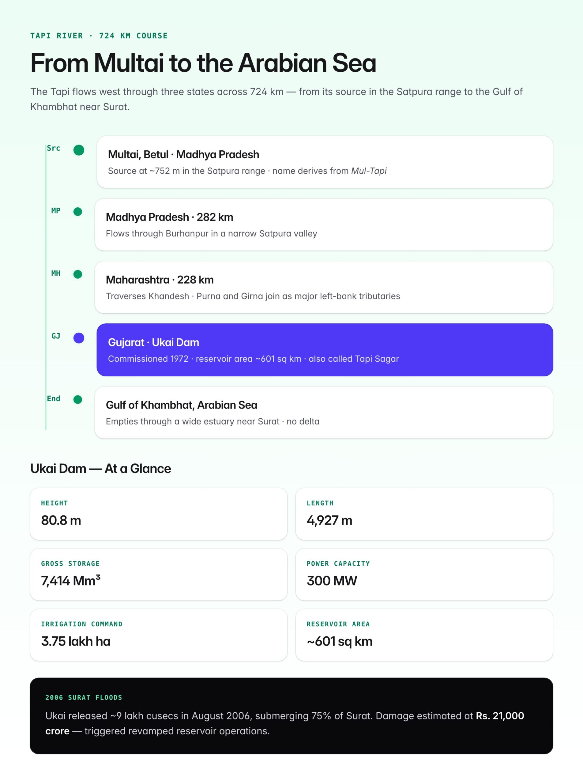
The name Multai derives from Mul-Tapi — "origin of Tapi". A sacred temple and tank at Multai mark the source in the Betul district, Satpura range, at around 752 m elevation.
Stage 1 — Madhya Pradesh (~282 km)
| Section | Features |
|---|---|
| Multai to Burhanpur | Narrow valley; Satpura forests on both sides |
| Burhanpur | Historic city; Khandwa-Burhanpur region |
| Exits MP | Just west of Burhanpur |
Stage 2 — Maharashtra (~228 km)
| Section | Features |
|---|---|
| Enters at Shahada | Nandurbar district |
| Traverses Khandesh | Major tributaries Purna, Girna join here |
| Through Dhule and Jalgaon | Agricultural Khandesh plain |
| Exits at Navapur | Into Gujarat |
Stage 3 — Gujarat (~214 km)
| Section | Features |
|---|---|
| Songadh, Vyara | Tapi Sagar (Ukai) reservoir |
| Ukai Dam | Major multipurpose project |
| Surat city | Historic port; Kakrapar barrage downstream |
| Gulf of Khambhat | Empties into Arabian Sea via wide estuary |
Major Tributaries
| Tributary | Bank | Length | Origin |
|---|---|---|---|
| Purna | Left | ~373 km | Gawilgarh Hills, Satpura; largest Tapi tributary |
| Girna | Left | ~260 km | Western Ghats (Kem Peak) |
| Panzara | Left | ~160 km | Western Ghats, Dhule |
| Waghur | Left | ~121 km | Ajanta hills |
| Bori | Left | ~107 km | Satmala hills |
| Arunavati | Right | ~64 km | Satpura slopes |
| Gomai | Right | ~80 km | Satpura foothills |
| Aner | Right | ~67 km | Satpura |
Most tributaries join from the left bank — draining the long northern flank of the Ajanta/Satmala range.
Purna — The Largest Tributary
- Originates in Gawilgarh Hills, part of the Satpuras
- Flows through Amravati district of Maharashtra
- Larger than the main Tapi at confluence in terms of mean flow
- Drains the Khandesh region along with parent river
Ukai Dam — "Tapi Sagar"
The Ukai Dam is the largest project on the Tapi and one of India's largest multipurpose reservoirs.
| Aspect | Detail |
|---|---|
| Location | Songadh, Tapi district, Gujarat |
| Commissioned | 1972 |
| Type | Composite (earthen + masonry gravity) |
| Height | 80.8 m |
| Length | 4,927 m |
| Reservoir area | ~601 sq km (second-largest in India by area after Hirakud) |
| Gross storage | 7,414 million m³ |
| Installed capacity (HEP) | 300 MW |
| Irrigation command | ~3.75 lakh hectares |
| Also called | Tapi Sagar / Vallabh Sagar |
Purposes of the Ukai Dam
| Purpose | Beneficiary |
|---|---|
| Irrigation | Large areas of South Gujarat |
| Flood control | Surat and downstream cities |
| Drinking water | Surat, Navsari |
| Hydropower | Western Region grid |
| Industrial water | Hazira industrial complex |
Kakrapar Weir
Downstream of Ukai is the Kakrapar Weir (1958), the older of the two main Tapi structures. It diverts water for irrigation and supplies Kakrapar Atomic Power Station (KAPS).
Surat and the Tapi Estuary
| Aspect | Detail |
|---|---|
| Mouth | Opens into Gulf of Khambhat through an estuary |
| Tidal influence | Up to ~40 km upstream |
| No delta | Fast flow and strong tides prevent delta formation |
| Historic port | Surat was the primary Mughal-era port of western India |
| Modern significance | Surat is a major diamond, textile, and petrochemical hub |
2006 Surat Floods
Surat experienced catastrophic floods in August 2006 when Ukai Dam released ~9 lakh cusecs of water. Almost 75% of the city was submerged, causing an estimated Rs. 21,000 crore in damage. This led to revamped reservoir operations and early warning systems.
Tapi vs Narmada — Comparison
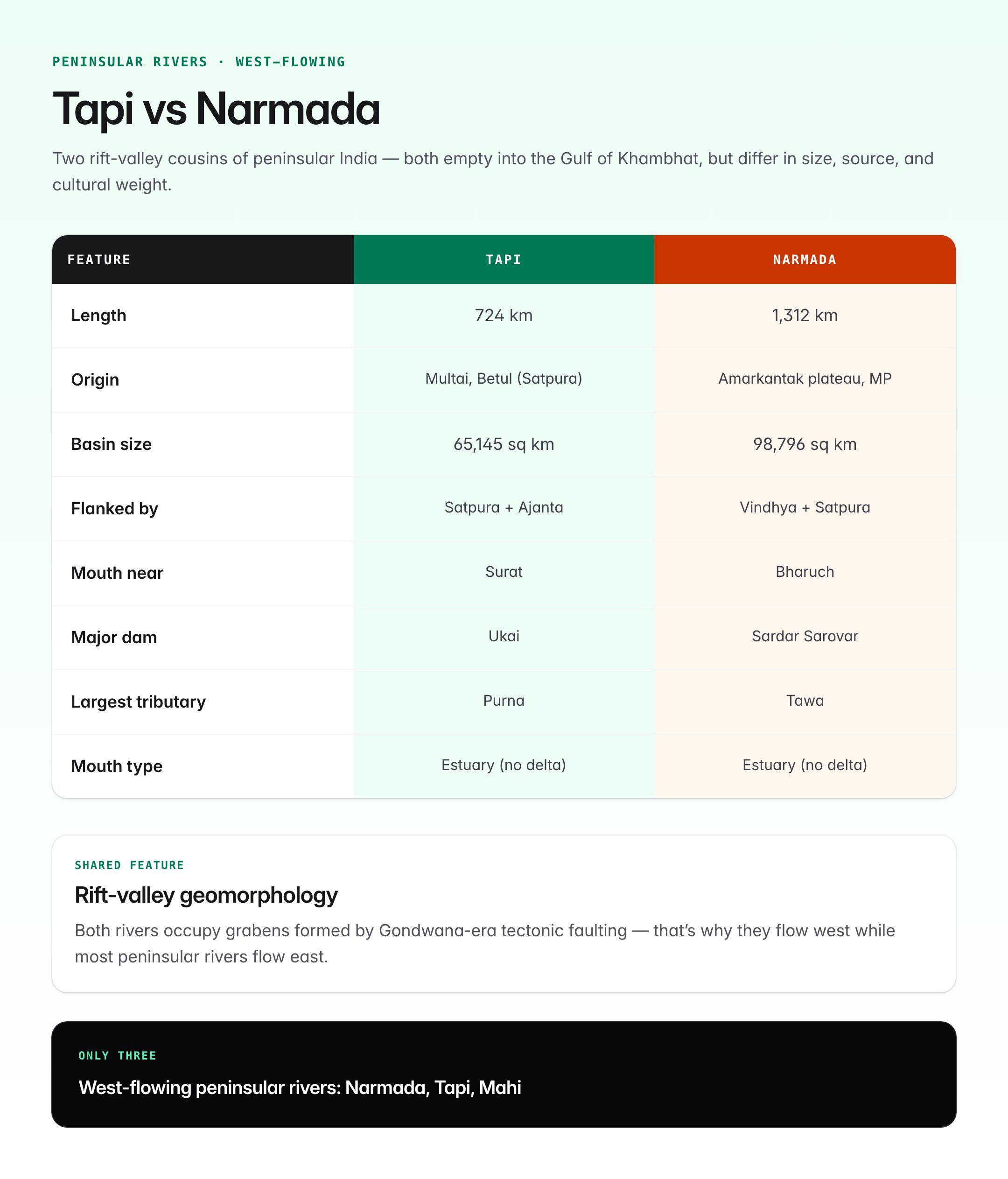
The two rivers are geomorphological cousins but differ in several ways.
| Feature | Narmada | Tapi |
|---|---|---|
| Length | 1,312 km | 724 km |
| Origin | Amarkantak plateau, MP | Multai, Betul, MP (Satpura) |
| States | MP, Maharashtra, Gujarat | MP, Maharashtra, Gujarat |
| Rift valley | Yes (between Vindhya and Satpura) | Yes (between Satpura and Ajanta/Satmala) |
| Outlet | Gulf of Khambhat (near Bharuch) | Gulf of Khambhat (near Surat) |
| Basin size | 98,796 sq km | 65,145 sq km |
| Mouth type | Estuary | Estuary |
| Delta | None | None |
| Major dam | Sardar Sarovar (Gujarat) | Ukai (Gujarat) |
| Largest tributary | Tawa | Purna |
| Religious significance | Very high (Parikrama tradition) | Regional (Multai, Burhanpur) |
| Interlink proposed | Narmada-Kshipra-Chambal link | Tapi-Narmada (proposed in NRLP) |
Both rivers arose as grabens during Gondwana-era faulting — but the Narmada is larger, older in cultural memory, and flows closer to the Vindhyas, while the Tapi hugs the southern Satpura flank.
Other Major Projects on the Tapi
| Project | State | Purpose |
|---|---|---|
| Hathnur Dam | Maharashtra | Irrigation |
| Gidhade Project | Maharashtra | Irrigation |
| Upper Tapi Project | Maharashtra | Irrigation |
| Jamda Dam | Maharashtra | Irrigation |
| Kakrapar Weir | Gujarat | Irrigation, cooling for KAPS |
| Singhanpur barrage | Gujarat | Drinking water, navigation |
Ecology of the Tapi Basin
| Element | Detail |
|---|---|
| Forest cover | Teak-dominated dry deciduous forests in Satpura and Ajanta flanks |
| Wildlife | Melghat Tiger Reserve on Purna tributary |
| Fish species | Mahseer, catla, rohu; Hilsa formerly migrated up to Ukai but cut off by dam |
| Birds | Sarus crane, painted stork in floodplains |
| Estuary ecology | Mangroves around Surat; mudflats |
Economic Significance
- Khandesh agricultural region — cotton, bananas, sugarcane
- South Gujarat — textiles, diamonds, power generation
- Surat port and petrochemical hub
- Hydropower via Ukai
- Tourism — Burhanpur, Melghat, Surat heritage
Issues and Concerns
| Issue | Explanation |
|---|---|
| Pollution | Industrial effluents from Surat, Hazira, Tarapur |
| Siltation at Ukai | Reduced storage capacity over decades |
| Floods | Unregulated releases; urban flooding in Surat |
| Water scarcity | Over-abstraction in Khandesh and South Gujarat |
| Salinity ingress | Estuary salinity affecting downstream agriculture |
| Proposed interlinking | Par-Tapi-Narmada link — controversial due to tribal displacement in Nashik-Valsad |
Par-Tapi-Narmada Link
Part of the National River Linking Project (NRLP), this proposes transferring surplus water from Par, Nar, Auranga, Ambica, and upper Tapi to water-scarce parts of Narmada and Saurashtra. It has faced strong opposition from tribal communities in Gujarat and Maharashtra and environmental groups, and was put on hold in 2022.
UPSC Relevance
GS1 (Physical Geography): Indian drainage systems, peninsular rivers, rift valleys, comparative hydrology. GS3 (Environment, Economy): River basin management, irrigation, interlinking of rivers.
Key Prelims facts:
- Tapi is also spelled Tapti
- Origin: Multai, Betul district, Satpura Range, Madhya Pradesh
- Source elevation: ~752 m
- Total length: 724 km; 3 states: MP, Maharashtra, Gujarat
- West-flowing; empties into Gulf of Khambhat via Arabian Sea, near Surat
- Rift valley river — between Satpura and Ajanta/Satmala ranges
- No delta — forms an estuary
- Largest tributary: Purna (left bank)
- Other tributaries: Girna, Panzara, Waghur, Bori (all left bank)
- Ukai Dam (Gujarat, commissioned 1972) is the major multipurpose project — also called Tapi Sagar
- Ukai reservoir area ~601 sq km (second-largest by area after Hirakud)
- Kakrapar Weir downstream of Ukai; supplies KAPS atomic plant
- 2006 Surat Floods caused major damage after Ukai releases
- Only three major west-flowing peninsular rivers: Narmada, Tapi, Mahi
- Par-Tapi-Narmada link — part of NRLP; put on hold in 2022 due to tribal opposition