Introduction
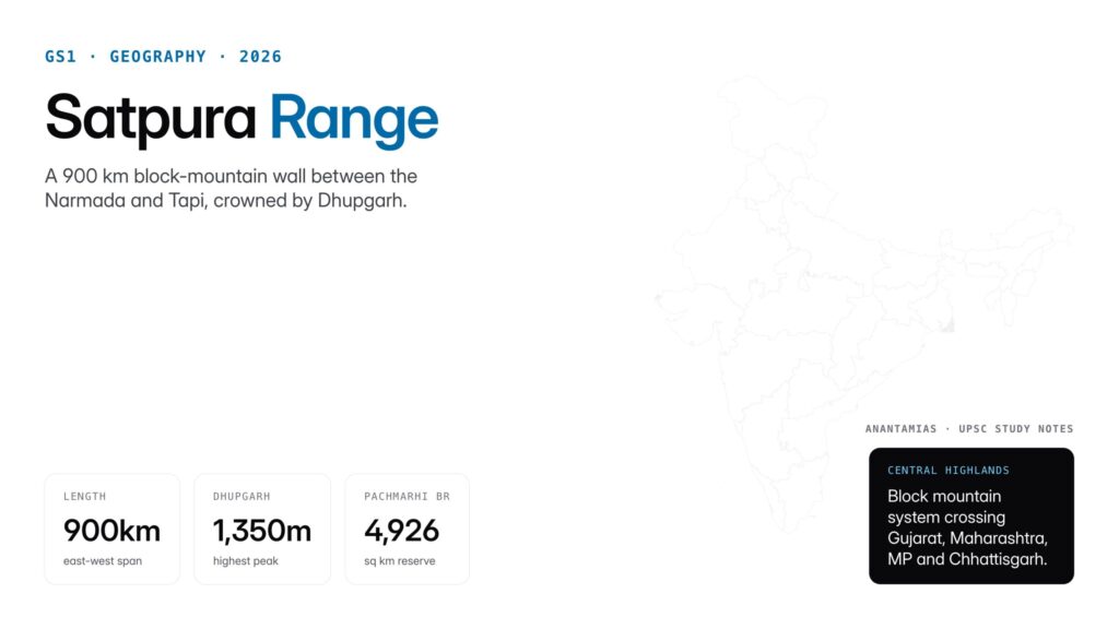
The Satpura Range is one of peninsular India’s most strategically placed mountain systems, forming a east-west wall that separates the Narmada river basin to the north from the Tapi basin to the south. Stretching roughly 900 kilometres across central India, it passes through Gujarat, Maharashtra, Madhya Pradesh, and Chhattisgarh, making it a geographic backbone for the central Indian plateau.
For UPSC aspirants, the Satpura Range appears across multiple syllabus pillars. It is Prelims material on physical features, Mains GS1 on Indian geography and monsoon, a biodiversity hotspot in environment topics, and a question of internal security and tribal affairs in its heavily forested central stretches. The range also anchors several iconic national parks including Satpura, Pachmarhi, and Kanha.

Quick Facts at a Glance
| Attribute | Detail |
|---|---|
| Type | Block mountain (horst) of peninsular India |
| Length | ~900 km |
| Orientation | East-west |
| States covered | Gujarat, Maharashtra, Madhya Pradesh, Chhattisgarh |
| Highest peak | Dhupgarh (1,350 m) in Pachmarhi |
| Bounds | Narmada river (north), Tapi river (south) |
| Major sub-ranges | Rajpipla Hills, Mahadeo Hills, Maikal Range |
| Main rivers originating | Tapi, Sone, Mahanadi headwaters |
| Biosphere reserve | Pachmarhi Biosphere Reserve (1999) |
| Key tiger reserve | Satpura Tiger Reserve |
| Meaning of name | Sat (seven) + pura (folds/mountains) in Sanskrit |
Background and Historical Context
The Satpura Range is one of the oldest mountain systems on the Indian subcontinent, formed during the late Precambrian era roughly 600 million years ago and repeatedly uplifted by block-faulting tectonics. Unlike the fold-mountain Himalayas, the Satpuras are classified as block or horst mountains that rose along parallel faults while the Narmada and Tapi grabens sank between them. This structural character explains their rounded tops, broad summits, and scarp-and-valley morphology.
The name Satpura literally means “seven folds” or “seven mountains,” reflecting the Sanskrit roots sat (seven) and pura (mountain or fold). Classical geographic texts and travellers’ accounts from Kalidasa to Ibn Battuta mention the range under different names. During Mughal and Maratha periods the Satpuras functioned as a natural corridor between northern plains and the Deccan, with forts like Asirgarh commanding key passes.
In the colonial era British geologists including W.T. Blanford mapped the range and documented its Gondwana coal deposits, which later supported the coalfields of Pench, Kanhan, and the Wardha valley. The range’s forests were also a refuge for communities like the Korkus, Gonds, Bhils, and Baigas, who retain significant populations in the region today. Post-independence the area has seen protection through the Wildlife Protection Act, 1972 and the declaration of Pachmarhi Biosphere Reserve in 1999 under the Man and Biosphere Programme.
Key Geography Features
Location and Extent
The Satpura Range runs parallel to the Vindhyas but south of them. It starts in the west near the Rajpipla Hills in Gujarat, continues through Maharashtra’s Jalgaon and Amravati districts, crosses central Madhya Pradesh through the Mahadeo Hills, and tapers eastward into the Maikal Range on the Chhattisgarh border. The range defines the watershed between the Arabian Sea-bound Tapi and Narmada and the Bay of Bengal-bound Sone and Mahanadi.
Sub-Ranges
Three main sub-ranges make up the system. The Rajpipla Hills form the western extremity in Gujarat, with modest elevations of 600 to 800 metres. The Mahadeo Hills occupy the centre in Madhya Pradesh and rise to 1,350 metres at Dhupgarh peak near Pachmarhi. The Maikal Range turns north-south in the east, curving through Amarkantak, where it meets the Vindhyas and gives rise to the Narmada and Sone rivers.
Peaks and Elevations
Dhupgarh, at 1,350 metres, is the highest peak of the Satpuras and indeed of the entire central Indian highlands. It lies inside the Pachmarhi hill station in Madhya Pradesh. Other notable peaks include Astachal (1,325 m), Mahadeo Peak (1,352 m near Pachmarhi), and Amarkantak (1,048 m), the last sacred as the source of the Narmada and Sone.
Rivers
The Tapi river originates in the Satpuras at Multai in Madhya Pradesh and flows west through Maharashtra and Gujarat to enter the Arabian Sea near Surat. The Narmada, though not originating in the Satpuras themselves, flows along the northern foothills in the Narmada graben. The Sone, a major left-bank tributary of the Ganga, rises at Amarkantak along with the Narmada. The Mahanadi has headwaters in the eastern Satpuras and Chhotanagpur.
Climate and Vegetation
The range receives 1,000 to 1,500 mm of annual rainfall, mostly during the southwest monsoon. It hosts dense tropical moist deciduous forests dominated by sal (Shorea robusta) and teak (Tectona grandis), along with bamboo, mahua, and tendu. The forests support tiger, leopard, gaur, sloth bear, Indian giant squirrel, and over 300 bird species. Pachmarhi is famous for orchids and rare medicinal plants.
Passes and Connectivity
The Satpuras historically restricted north-south movement. The Burhanpur Gap between the Satpura and the Gawilgarh Hills is the most important pass, used today by National Highway 52 and major railway lines connecting the Gangetic plains to the Deccan.
Significance for UPSC and General Knowledge
- Directly tested in Prelims on peak names, sub-ranges, river origins, and biosphere reserves.
- Central to Mains GS1 questions on physical geography and peninsular drainage.
- Connects with environment topics on tiger reserves, biosphere reserves, and Project Tiger.
- Anchors tribal affairs discussions on Korku, Gond, Bhil, and Baiga communities and PESA implementation.
- Relevant to questions on coal mining, Gondwana geology, and the Panna-Pench water dispute.
- Links to internal security on left-wing extremism affected districts in the eastern Satpura belt.
Detailed Analysis: Geological and Ecological Importance
The Satpura Range is a textbook example of block-mountain geomorphology on the Indian peninsular shield. While the Himalayas are a comparatively recent fold mountain born of plate collision, the Satpuras rose through brittle fracturing of an ancient continental plate, with horsts (uplifted blocks) rising above rift valleys or grabens. The Narmada and Tapi rift valleys are classic examples of such grabens, making the Satpura geology a central chapter in any physical geography syllabus.
Ecologically, the Satpuras anchor one of central India’s largest contiguous forest stretches. The Pachmarhi Biosphere Reserve spans 4,926 square kilometres and includes three protected areas: Satpura National Park, Bori Wildlife Sanctuary, and Pachmarhi Wildlife Sanctuary. The reserve was inscribed into UNESCO’s World Network of Biosphere Reserves in 2009. Adjacent protected areas include Kanha National Park and Pench National Park, both tiger reserves that form part of the Satpura-Maikal landscape.
The range is also the hydrological watershed for multiple river systems. The Narmada, Tapi, Sone, and upper Mahanadi all draw on Satpura rainfall. Because of this, any disturbance to forest cover on the range has basin-wide consequences for agriculture, drinking water, and hydropower as far as Gujarat, Uttar Pradesh, and Bihar. The proposed linking of the Par-Tapi-Narmada rivers would directly affect Satpura hydrology and has been under debate for decades.
Mineral wealth is another Satpura asset. The Gondwana sedimentary rocks hidden in the range contain coal (Pench, Kanhan, Pathakhera), manganese, bauxite, and limestone. Balaghat district on the eastern end has one of Asia’s largest manganese reserves. Coal mining, while economically vital, creates continuous tensions with forest conservation and tribal rights, illustrated by the controversy over the Singrauli and Hasdeo Arand coalfields at the Satpura-Vindhyan margin.
Comparative Perspective
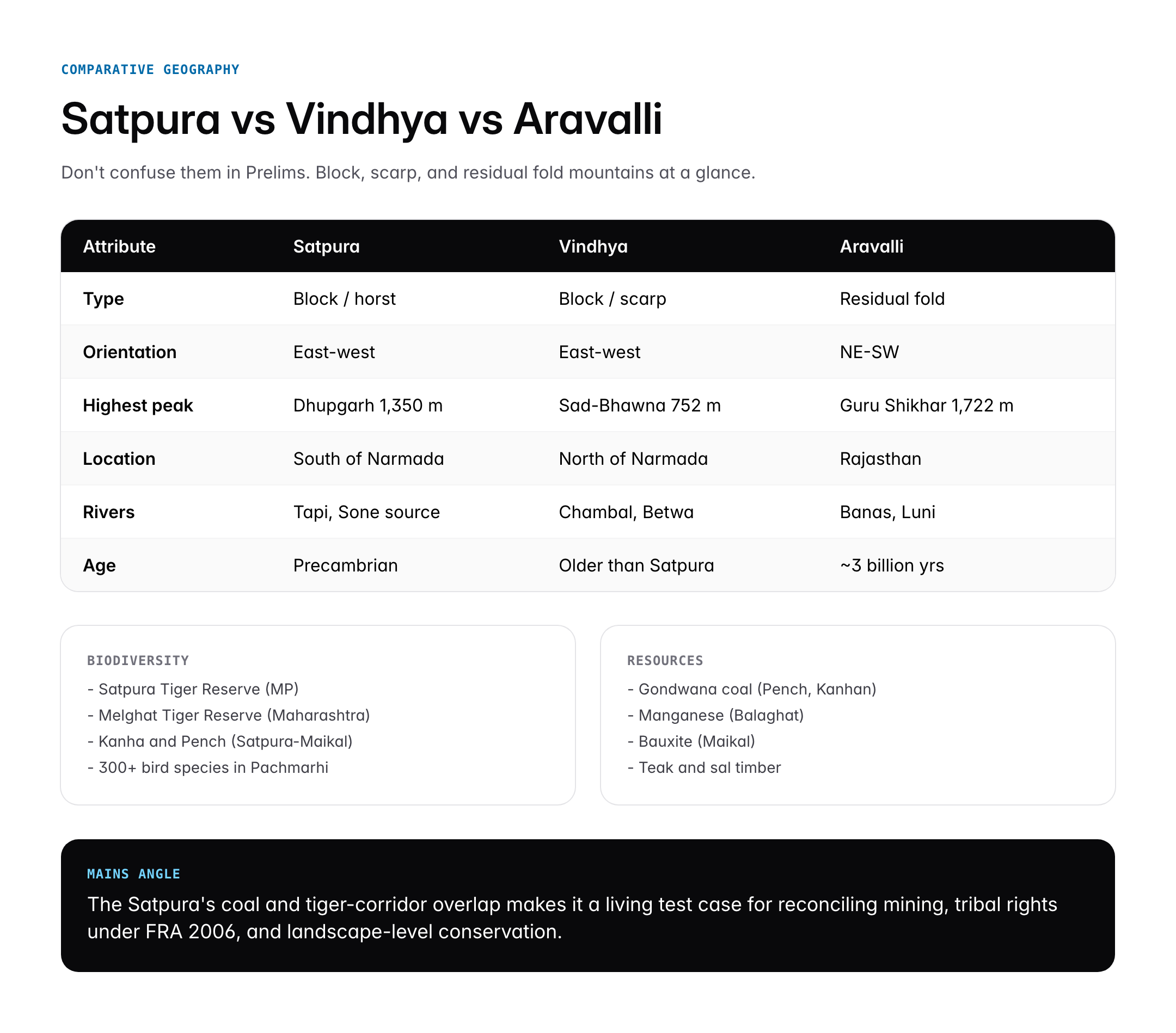
Aspirants often confuse the Satpuras with the Vindhyas, so a comparison is essential.
| Attribute | Satpura Range | Vindhya Range | Aravalli Range |
|---|---|---|---|
| Type | Block / horst | Block / scarp | Fold / residual |
| Age | Precambrian | Older than Satpura | Oldest, ~3 billion years |
| Orientation | East-west | East-west | NE-SW |
| Highest peak | Dhupgarh (1,350 m) | Sad-Bhawna (752 m) | Guru Shikhar (1,722 m) |
| Key river | Tapi (originates) | Chambal, Betwa | Banas, Luni |
| Key state | Madhya Pradesh | Madhya Pradesh | Rajasthan |
In global terms, the Satpuras resemble block mountain systems like the Basin and Range Province in the western United States or the Vosges of France, where parallel faults have produced alternating highlands and valleys. The east-west grain of the Satpuras is unusual on the Indian peninsula where most ranges trend north-south, and this orientation has a direct consequence for monsoon rainfall distribution by acting as a barrier that intensifies orographic rain on southern slopes.
Challenges and Controversies
The Satpura Range faces pressures on three fronts. First, mining expansion threatens forest integrity. Coal blocks in Pench, Pathakhera, and Singrauli continue to shrink elephant and tiger corridors. The Hasdeo Arand coal mine controversy in Chhattisgarh, while technically on the eastern Maikal margin, represents the same policy conflict. Second, tribal displacement remains unresolved. Forest Rights Act, 2006 implementation has been uneven across Satpura districts, with many claims pending or rejected, leading to livelihood insecurity for Korku, Gond, and Baiga communities.
Third, climate change and fire risk have grown visibly in the last decade. Forest fires, once rare in moist deciduous Satpura forests, have become more frequent in Pachmarhi, Satpura, and Melghat in successive dry summers. Reduced monsoon rainfall and earlier leaf fall compound the risk. Conservationists argue for community-based fire management and restoration of traditional fire breaks, while state forest departments continue to rely largely on mechanical methods.
A fourth concern is the left-wing extremism legacy in eastern Satpura districts such as Balaghat, which affects both conservation and tribal welfare. Security operations, development schemes, and conservation programmes must coexist, a challenge captured in the continuing debates on PESA implementation and the Fifth Schedule.
Prelims Pointers
- Satpura is a block mountain (horst), not a fold mountain.
- Highest peak: Dhupgarh (1,350 m) in Mahadeo Hills near Pachmarhi.
- Range runs east-west across Gujarat, Maharashtra, Madhya Pradesh, and Chhattisgarh.
- Tapi river originates at Multai in the Satpura Range.
- Narmada and Sone both originate at Amarkantak on the Maikal Range.
- Satpura Tiger Reserve is in Madhya Pradesh.
- Pachmarhi Biosphere Reserve inscribed in UNESCO MAB network in 2009.
- Burhanpur Gap is the key pass through the Satpuras.
- Maikal Range is the eastern extension of the Satpuras.
- Satpura houses significant Gondwana coal reserves.
- Rajpipla Hills mark the western extremity of the range.
- The range separates the Narmada basin (north) from the Tapi basin (south).
Mains Practice Questions
Q1. “The Satpura Range is a classic example of block-mountain geomorphology with far-reaching ecological consequences.” Discuss. (250 words)
- Explain horst-graben tectonics and differentiate from Himalayan fold mountains.
- Link geology to hydrology: Narmada graben, Tapi graben, origin of Tapi and Sone.
- Assess ecological role: biosphere reserve, tiger landscape, Gondwana mineral wealth.
Q2. Examine the conservation challenges facing the Satpura landscape in the context of mining, tribal rights, and climate change. (250 words)
- Coal mining pressures: Pench, Pathakhera, Hasdeo Arand.
- Forest Rights Act implementation gaps and tribal displacement.
- Increasing forest fires and monsoon variability; suggest integrated landscape approach.
Conclusion
The Satpura Range is more than a geographic feature on the peninsular map. It is a tectonic record, a biodiversity stronghold, a watershed for four great rivers, a home for some of India’s oldest tribal communities, and a mineral storehouse that has shaped the economy of central India. Its east-west orientation makes it unique among Indian peninsular ranges and gives it a decisive role in shaping monsoon rainfall patterns in the Deccan interior.
For the UPSC aspirant, mastering the Satpura Range opens doors to topics as varied as block mountain geomorphology, biosphere reserves, tiger conservation, tribal affairs, and India’s coal economy. Remembering Dhupgarh as the highest peak, Pachmarhi as the biosphere reserve, and Multai as the source of the Tapi gives a compact map from which larger connections can be built. The range reminds us that geography in India is never just geography; it weaves together ecology, culture, economy, and politics.
Frequently Asked Questions
What is the Satpura Range?
The Satpura Range is a block mountain system of peninsular India running east-west for about 900 kilometres across Gujarat, Maharashtra, Madhya Pradesh, and Chhattisgarh. It lies between the Narmada river to the north and the Tapi river to the south. The name means seven folds in Sanskrit, and the range is part of India’s central highlands with Dhupgarh as its highest peak at 1,350 metres.
Why is the Satpura Range important for UPSC?
The Satpura Range is tested in Prelims on its peaks, sub-ranges, rivers, and biosphere reserves, and in Mains GS1 on block-mountain geomorphology and peninsular drainage. It appears in environment topics through Satpura Tiger Reserve and Pachmarhi Biosphere Reserve, in tribal affairs through Korku and Gond communities, and in resource geography through Gondwana coal deposits. Its east-west orientation influences monsoon rainfall patterns in central India.
How is the Satpura Range related to the Narmada and Tapi rivers?
The Satpura Range forms the watershed between the Narmada basin to the north and the Tapi basin to the south. The Narmada flows through a rift valley or graben along the northern foothills of the Satpuras, while the Tapi actually originates at Multai in the Satpura Range itself and flows west through Maharashtra and Gujarat. Both rivers drain into the Arabian Sea.
What is the highest peak of the Satpura Range?
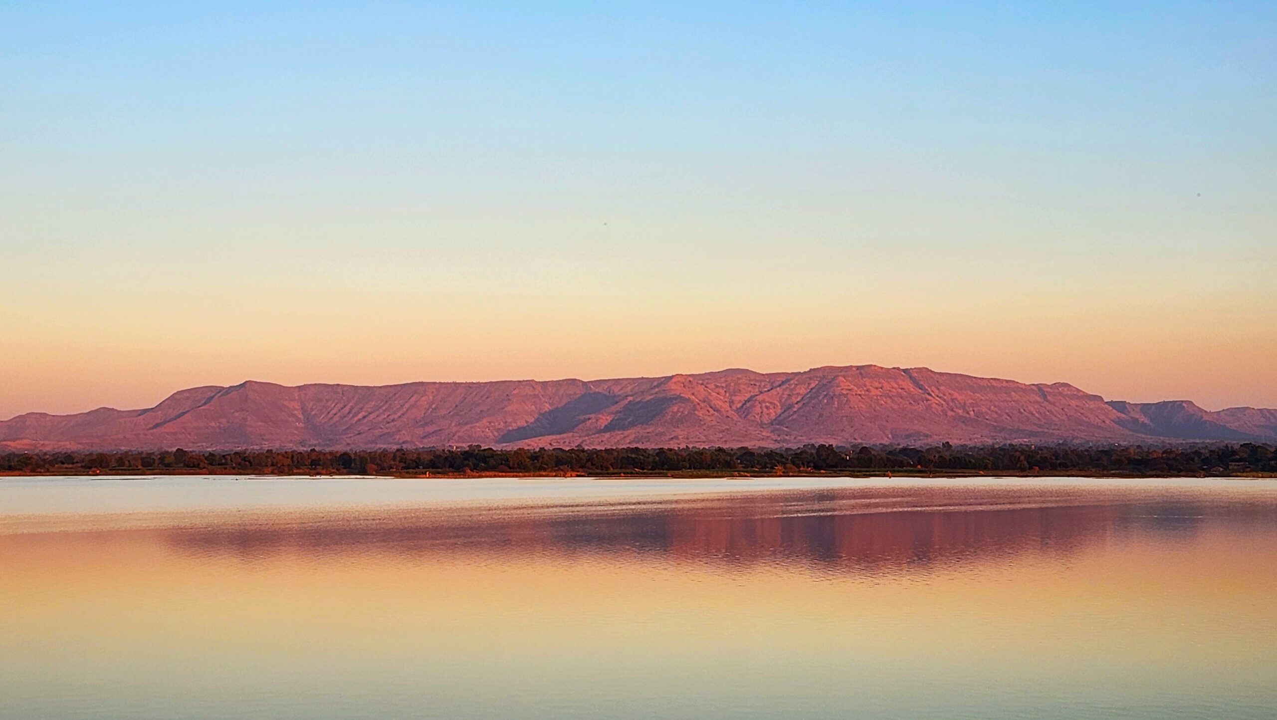
Dhupgarh is the highest peak of the Satpura Range, rising to 1,350 metres above sea level. It lies in the Mahadeo Hills near the hill station of Pachmarhi in Madhya Pradesh’s Hoshangabad district. Dhupgarh is famous for panoramic views of the Satpura landscape and dramatic sunsets, and is a popular destination within the Pachmarhi Biosphere Reserve.
What sub-ranges make up the Satpuras?
The Satpura Range is traditionally divided into three sub-ranges. The Rajpipla Hills form the western extremity in Gujarat with moderate elevations around 600-800 metres. The Mahadeo Hills occupy the centre in Madhya Pradesh and contain Dhupgarh and Pachmarhi. The Maikal Range turns north-south at the eastern end, curving through Amarkantak where the Narmada and Sone rivers originate along the Chhattisgarh border.
Which national parks are in the Satpura landscape?
The Satpura landscape hosts several iconic protected areas. Satpura National Park, Bori Wildlife Sanctuary, and Pachmarhi Wildlife Sanctuary together form the Pachmarhi Biosphere Reserve of 4,926 square kilometres. Nearby Kanha National Park, Pench National Park, and Melghat Tiger Reserve extend the Satpura-Maikal tiger landscape. UNESCO inscribed Pachmarhi into the World Network of Biosphere Reserves in 2009.
How does the Satpura differ from the Vindhya Range?
Both ranges run east-west across central India, but they differ in elevation and location. The Satpura lies south of the Narmada river with Dhupgarh at 1,350 metres, while the Vindhya lies to the north with peaks generally below 800 metres. The Vindhyas are also structurally older. Together they define the geographic and cultural boundary between northern and southern India, with the Narmada rift valley between them.
What tribal communities live in the Satpura Range?
The Satpura forests are home to several major tribal communities. The Korku, Gond, Bhil, and Baiga are the largest groups, with significant populations in Madhya Pradesh, Maharashtra, and Chhattisgarh. These communities retain rich traditions of forest-based livelihood, shifting cultivation, and ethnobotany. Their rights are protected under the Forest Rights Act, 2006 and the Panchayats Extension to Scheduled Areas (PESA) Act, 1996.
Tell Google you want more of this.
Add Anantam IAS as a preferred sourceOne tap, and this site shows up more often in your own Top Stories, AI Overviews and AI Mode. Remove it any time.