TRISHNA Mission: Indo-French Thermal Infrared Satellite for Water, Crops, and Climate
A complete UPSC GS-III explainer on the TRISHNA mission. Covers the Indo-French thermal infrared satellite, its TIR and VNIR-SWIR payloads, the Sun-synchronous orbit, applications in water resources, urban heat, agriculture, and how it fits into ISRO and CNES cooperation.
The Earth’s surface radiates heat in the long-wave infrared band. Read that radiation accurately and you can map evapotranspiration over a wheat field, track an urban heat island over Delhi, watch a glacier melt over Sikkim, and detect a thermal anomaly under a forest canopy. No optical satellite at moderate resolution does this well today. The two missions that come closest, NASA’s MODIS and the Landsat thermal band, sit in awkward sweet spots, either too coarse for fields or too infrequent for water management.
TRISHNA is the joint Indian and French answer to this gap. The acronym expands to Thermal infraRed Imaging Satellite for High-resolution Natural resource Assessment, and the satellite is being built jointly by the Indian Space Research Organisation and the French space agency Centre national d’études spatiales. It is targeted for launch on a PSLV in 2026 to a Sun-synchronous orbit, with a five-year nominal mission life.
For UPSC GS-III, TRISHNA touches three syllabus areas at once. It is a space technology story about Indian Earth-observation capability, a climate and water resources story about high-resolution thermal mapping, and a strategic story about Indo-French scientific cooperation. This article walks through the mission design, the two payloads, the operational concept, the applications, and the broader Indo-French partnership context.
What TRISHNA Is
TRISHNA is a small to medium-class Earth observation satellite optimised for thermal infrared imaging at high spatial resolution. The thermal infrared band reads surface temperature, surface emissivity, and the closely related quantities of evapotranspiration, soil moisture stress, and urban heat anomaly.
The satellite is designed to fly in a Sun-synchronous orbit at around 761 kilometres altitude, with a local equatorial crossing time in the early afternoon when surface heating is near its peak. The orbit gives global coverage and a revisit time of three days, which is much faster than the 16-day Landsat thermal revisit. For water and crop monitoring, the three-day revisit is the operational sweet spot.
The mission has been jointly designed and developed by ISRO and CNES since the inter-agency announcement in 2018. ISRO leads the satellite bus, the launch on PSLV from Sriharikota, and the VNIR-SWIR payload. CNES leads the thermal infrared payload, payload electronics for the TIR instrument, and the data processing infrastructure that supports the thermal product chain.
The launch has slipped a few times since the original 2024 target. The current schedule places the launch in 2026 from the Satish Dhawan Space Centre. The satellite class is around 1.0 to 1.2 tonnes and the mission life is five years.
The Two Payloads
TRISHNA carries two scientific payloads that operate together to produce the high-value thermal data products.
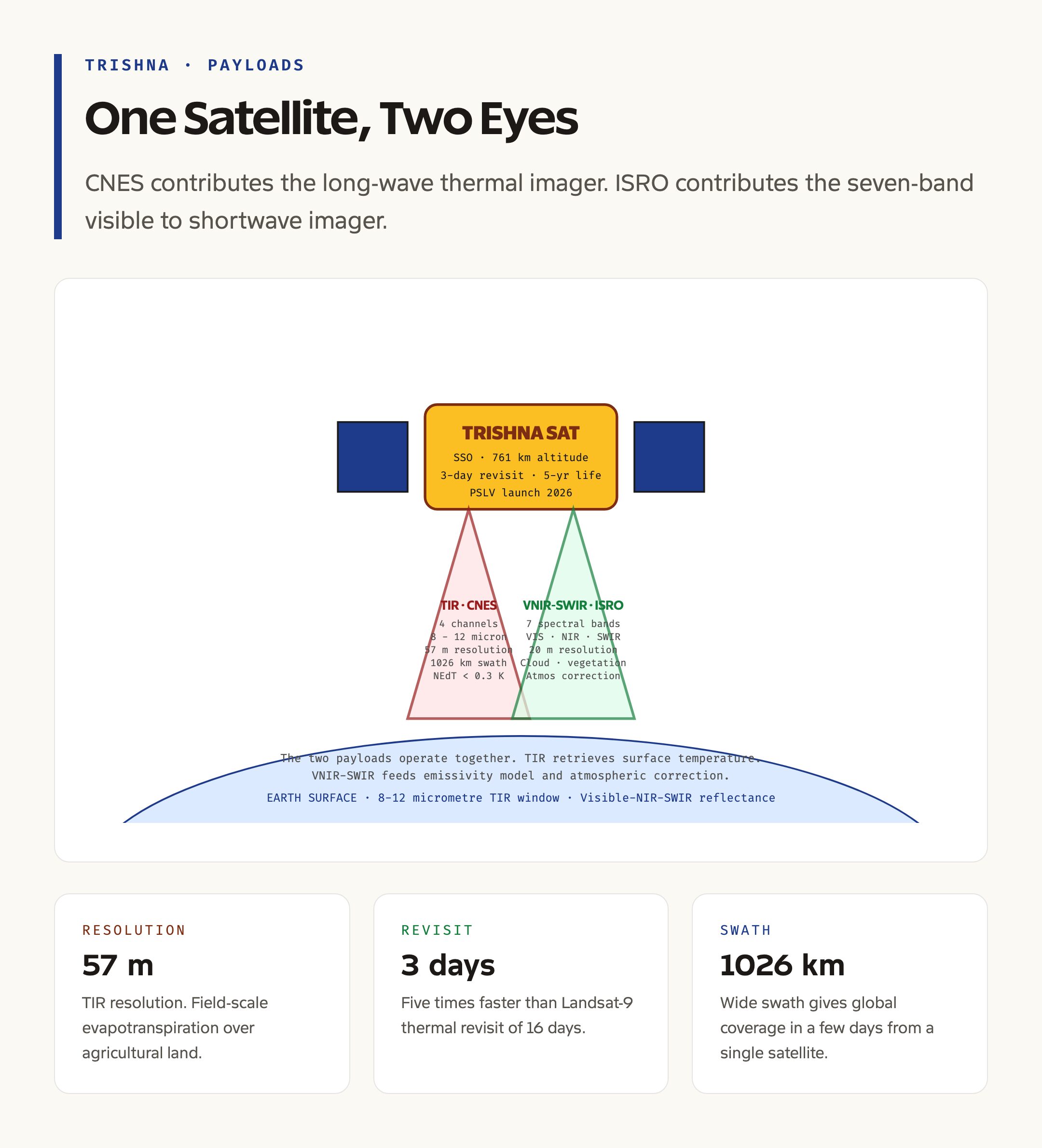
The Thermal InfraRed payload, contributed by CNES, is the primary instrument. It is a four-channel long-wave infrared imager that captures emitted radiation in the 8 to 12 micrometre band, which is the atmospheric window where Earth’s surface radiation is least absorbed by water vapour. The four channels are placed at carefully chosen wavelengths that allow surface temperature and surface emissivity to be retrieved simultaneously, using the temperature-emissivity separation algorithm that CNES has developed over the previous Indo-French Megha-Tropiques heritage.
The TIR payload’s spatial resolution is 57 metres at nadir, with a swath width of 1026 kilometres. The 57-metre resolution is the operational sweet spot for evapotranspiration over agricultural fields and for detailed urban heat mapping over Indian cities. The radiometric performance of the instrument, expressed as noise-equivalent temperature difference, is below 0.3 Kelvin, which gives the sensitivity needed to detect the small temperature differences that signal water stress in crops.
The Visible-Near Infrared and Short-Wave InfraRed payload, contributed by ISRO, is the supporting instrument. It is a seven-channel imaging spectrometer that captures reflectance in the visible, near infrared, and shortwave infrared bands. The bands are placed to support cloud detection, vegetation indices, surface reflectance correction, and atmospheric correction of the TIR data.
The VNIR-SWIR spatial resolution is 20 metres. The two payloads together provide the input data needed to compute land surface temperature, evapotranspiration, surface energy balance, and surface biophysical variables at a consistent spatial and temporal resolution.
The combination is what makes TRISHNA scientifically valuable. Thermal infrared alone gives surface temperature but the algorithm needs surface emissivity, which depends on vegetation cover, soil type, and surface moisture. The VNIR-SWIR data feeds the emissivity model. The atmospheric correction needs water vapour and aerosol estimates, which the VNIR-SWIR data also supports.
Indo-French Space Cooperation
TRISHNA is the third major Indo-French Earth observation satellite, building on a partnership that goes back four decades.
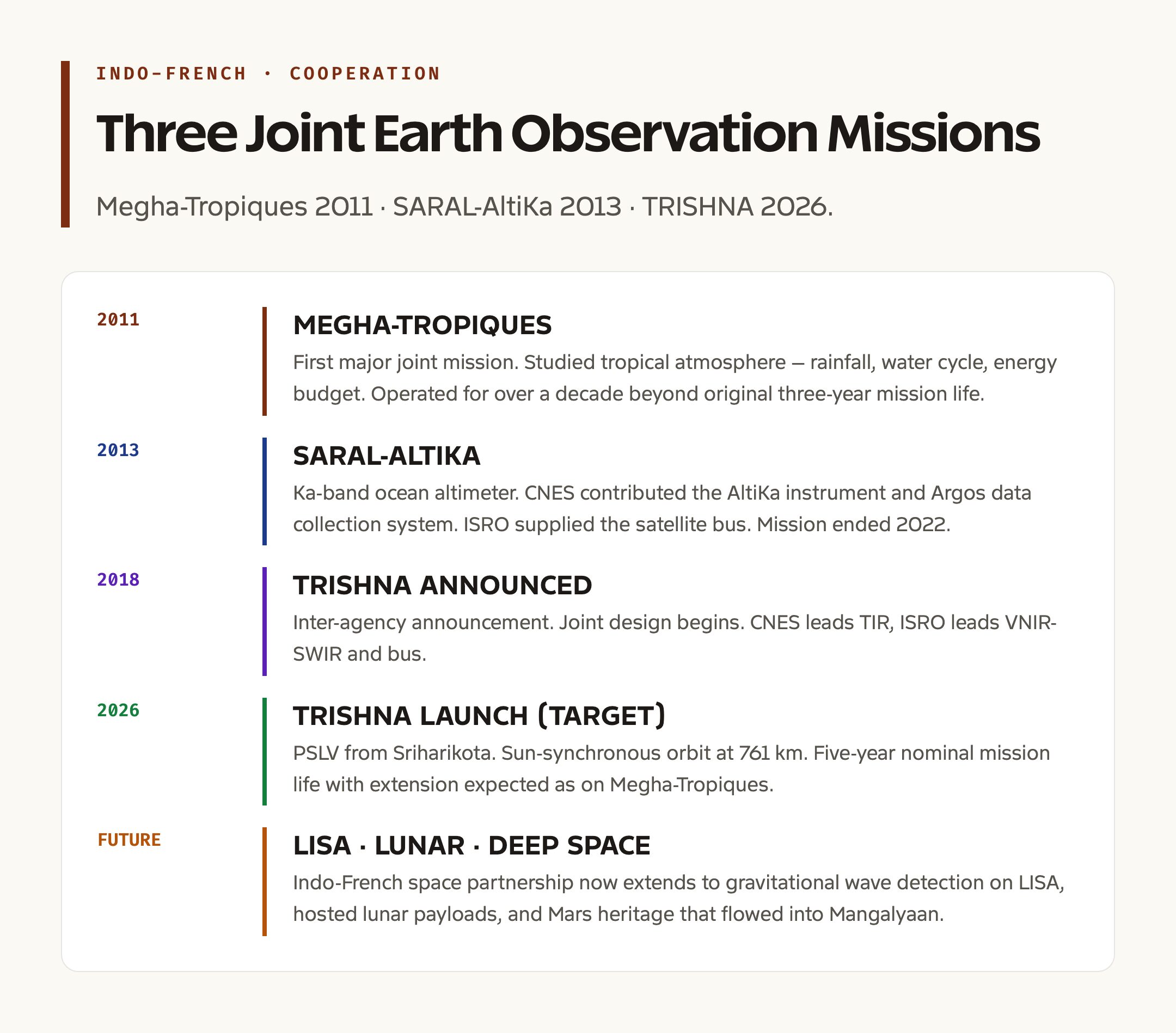
Megha-Tropiques was the first major joint mission. Launched in 2011, it studied the tropical atmosphere with instruments contributed by ISRO and CNES. The mission focused on rainfall, water cycle, and energy budget in the inter-tropical zone and ran for over a decade beyond its original three-year mission life. Megha-Tropiques set the template for joint mission design, joint data sharing, and joint algorithm development that TRISHNA inherits.
SARAL-AltiKa was the second joint mission. Launched in 2013, it carried the Ka-band altimeter Argos data collection system that CNES contributed, and the satellite bus was provided by ISRO. SARAL contributed to ocean surface topography and the global altimetry constellation that includes Jason satellites and the Sentinel-3 series. SARAL ended its mission in 2022.
TRISHNA is the third major mission in this lineage. The choice of thermal infrared as the focus reflects a gap that no operational mission fills today. Landsat-9 carries TIRS-2, but at 100-metre resolution and 16-day revisit. The European MicroCarb mission and NASA’s ECOSTRESS deliver high-quality thermal data but with their own limitations. TRISHNA fills the high-resolution, fast-revisit niche that water and agriculture applications need.
The cooperation extends beyond Earth observation. The Indo-French space partnership now includes joint work on gravitational wave detection on the LISA mission, hosted payload arrangements on lunar missions, and the Mars orbit mission heritage that flowed back into Mangalyaan. The Indo-French strategic dialogue has placed space cooperation in a high-priority bucket since 2019.
Applications of TRISHNA Data
TRISHNA’s data products feed several major application areas, each of which has direct policy relevance for India.
Water resource management is the headline application. Evapotranspiration is the dominant term in the water budget over irrigated cropland. Measuring it accurately across an entire river basin, with three-day revisit, would transform irrigation scheduling, groundwater management, and water-use efficiency policy. The Pradhan Mantri Krishi Sinchayee Yojana and the Atal Bhujal Yojana both need evapotranspiration data at scale, and TRISHNA is the first Indian source that can deliver this at field-scale resolution.
Agricultural drought assessment is a closely related application. Water stress in crops shows up as raised canopy temperature long before visible wilting begins. The National Agricultural Drought Assessment and Monitoring System, run by Mahalanobis National Crop Forecast Centre, uses thermal indices for drought monitoring. TRISHNA’s 57-metre resolution and three-day revisit move this monitoring from the district scale to the field scale.
Urban heat island monitoring uses the same thermal capability over cities. Indian cities run several degrees hotter than surrounding countryside, and the heat island effect on health, energy consumption, and air quality is a major concern. The National Disaster Management Authority has begun framing extreme heat as a notified disaster category, and city-level heat action plans need fine-grained thermal data. TRISHNA supports this at the neighbourhood scale.
Cryosphere monitoring covers glaciers, snow cover, and high-altitude lakes. The Hindu Kush Himalaya’s glaciers are losing mass under climate warming, and thermal imaging gives a key input to surface energy balance models that drive melt-rate estimation. Glacial lake outburst flood risk assessment, especially after the 2023 South Lhonak Lake event in Sikkim, has become a national priority that thermal data supports.
Coastal and ocean applications include sea surface temperature mapping at the coastal zone, where finer resolution is needed for upwelling, fisheries, and pollution monitoring. The mid-day TIR data complements the morning sea surface temperature retrievals from MODIS and the Indian Oceansat-3 mission, which is also called EOS-06. We cover the Indian Earth observation chain in our EOS-08 explainer.
Forestry and forest fire applications include monitoring of forest canopy temperature, identification of thermal anomalies that signal early-stage fires, and assessment of fire scars after major events. The Forest Survey of India and the National Remote Sensing Centre run Indian forest monitoring programmes that will benefit from the TRISHNA data stream.
Climate science applications include validation of land surface models, climate reanalysis input, and direct measurement of surface energy budget terms. The Indian Institute of Tropical Meteorology, the Indian Council of Agricultural Research, and the climate modelling community will use TRISHNA data both directly and as input to assimilation systems.
Operational Concept and Data Distribution
TRISHNA is designed as an operational mission, not a science demonstration. The data products will flow through standardised processing chains and be distributed to government, research, and commercial users.
ISRO’s National Remote Sensing Centre at Hyderabad will run the Indian ground segment. The Bhuvan portal will host TRISHNA Level-1 and Level-2 data products under the same terms as other Indian Earth observation data. CNES’s ground segment in Toulouse will run the European distribution and serve users through the Theia data centre.
The data will be free for non-commercial use, with the standard ISRO and CNES data policies that have applied to previous joint missions. Commercial use is supported through the standard licensing routes.
The processing chain produces several Level-2 products. Land surface temperature is the headline product. Surface emissivity is the supporting product. Evapotranspiration is computed from a combination of TRISHNA data, meteorological inputs, and surface model outputs. Surface energy balance components are derived from a combination of incoming and outgoing radiation flux estimates. The processing chain is a joint development by CNES and ISRO, building on the heritage from Megha-Tropiques and the European MicroCarb effort.
A Level-3 product chain delivers gridded summaries at country and basin scales for water resource and climate applications. A Level-4 product chain feeds assimilation systems that combine TRISHNA data with land surface models to produce gridded soil moisture, drought index, and crop water requirement products.
What TRISHNA Means for India’s Earth Observation Programme
TRISHNA fits into a longer-term ISRO push to build a comprehensive Earth observation capability under the renamed EOS series. The Indian fleet today includes high-resolution optical satellites in the Cartosat lineage, multi-spectral satellites in the Resourcesat and Oceansat lineages, radar satellites in the RISAT and upcoming NISAR line, and microsatellites like EOS-08.
TRISHNA fills the thermal niche that this fleet does not yet cover at the resolution and revisit needed for operational use. Combined with NISAR’s L-band synthetic aperture radar capability, the Indian Earth observation portfolio will offer optical, thermal, and radar data at compatible spatial scales by 2027. The combination is comparable to the European Copernicus Sentinel constellation and gives India a sovereign data layer for climate, water, and agriculture policy.
The Indian Space Policy 2023 framework opens up commercial participation in Earth observation. Companies like Pixxel, Galaxeye, and Satellogic India operate or are deploying their own constellations, and the policy supports both public and private capability. TRISHNA’s free data policy creates a calibration anchor that commercial smallsats can build atop.
Frequently Asked Questions
What is the TRISHNA mission?
TRISHNA stands for Thermal infraRed Imaging Satellite for High-resolution Natural resource Assessment. It is a joint Earth observation mission of ISRO and the French space agency CNES, designed to deliver high-resolution thermal infrared imagery for water management, agriculture, urban heat, and climate applications. The satellite is targeted for launch on a PSLV in 2026 to a Sun-synchronous orbit at around 761 kilometres altitude with a five-year nominal mission life.
What payloads does TRISHNA carry?
TRISHNA carries two payloads. The Thermal InfraRed payload, contributed by CNES, is a four-channel long-wave infrared imager at 57-metre resolution that measures surface temperature and emissivity. The Visible-Near Infrared and Short-Wave InfraRed payload, contributed by ISRO, is a seven-channel imaging spectrometer at 20-metre resolution that supports vegetation, cloud, and atmospheric correction. The two work together to produce the high-value thermal products.
Why is high-resolution thermal infrared imaging important?
Surface temperature and emissivity are the inputs to evapotranspiration, soil moisture stress, urban heat island intensity, and surface energy balance computation. Coarse thermal data at hundreds of metres or kilometres is too averaged for field-scale agriculture, neighbourhood-scale urban heat, or local glacier monitoring. TRISHNA’s 57-metre resolution and three-day revisit gives the spatial and temporal granularity needed for operational use in water and climate applications.
How does TRISHNA fit into Indo-French space cooperation?
TRISHNA is the third major Indo-French Earth observation satellite. The first was Megha-Tropiques in 2011 for tropical atmospheric science. The second was SARAL-AltiKa in 2013 for ocean altimetry. TRISHNA inherits the joint mission design, data sharing, and algorithm development heritage of these previous missions and extends Indo-French cooperation into thermal infrared observation, where neither agency has a sovereign capability today.
What are the main applications of TRISHNA data?
The headline applications are water resource management and irrigation scheduling, agricultural drought assessment under the National Agricultural Drought Assessment and Monitoring System, urban heat island monitoring for city heat action plans, cryosphere and glacier monitoring in the Himalayas, coastal sea surface temperature, forest fire detection, and climate science model validation. The data feeds into Indian programmes including the Pradhan Mantri Krishi Sinchayee Yojana, Atal Bhujal Yojana, and the National Disaster Management Authority’s heatwave framework.
When will TRISHNA launch and how long will it operate?
TRISHNA is targeted for launch in 2026 from the Satish Dhawan Space Centre at Sriharikota on a PSLV. The mission life is five years. The orbit decay characteristics and the nominal fuel budget allow for extended operations beyond five years, similar to how Megha-Tropiques operated for over a decade past its three-year mission life. Data will be free for non-commercial use under the standard ISRO and CNES data policies, distributed through the Bhuvan portal and the Theia centre in Toulouse.