Waterfalls of India: Highest, Major and Complete List
Which is the highest waterfall in India, why heights differ across sources, and a complete river-wise list of every major Indian waterfall you need for UPSC.
Ask three different books which is the highest waterfall in India and you can get three answers. One says Kunchikal in Karnataka, one says Nohkalikai in Meghalaya, and an older one says Jog. They’re all “right” in their own way, and that single confusion is what trips up most aspirants on this topic. The fix is to stop asking “which is highest” and start asking “highest by what measure” because India ranks its falls in two different ways at once.
For UPSC this is a small, high-yield corner of physical geography. Waterfalls sit exactly where rivers meet relief, so a question about a fall is really a question about which river it’s on and which plateau edge it drops over. Get the river-state-height triplet right for a dozen falls and you’ve covered almost everything Prelims has ever asked, plus a clean hook for Mains answers on hydropower and the Western Ghats.
How Waterfalls Form: Rivers Meeting a Rock Edge
A waterfall forms wherever a river suddenly loses height over a steep step in its bed, and in India that step is almost always a plateau scarp or a band of hard rock. Picture the Cauvery flowing across the flat Deccan and then reaching the plateau’s eastern rim. The land falls away, and the river falls with it. That’s a waterfall in one sentence.
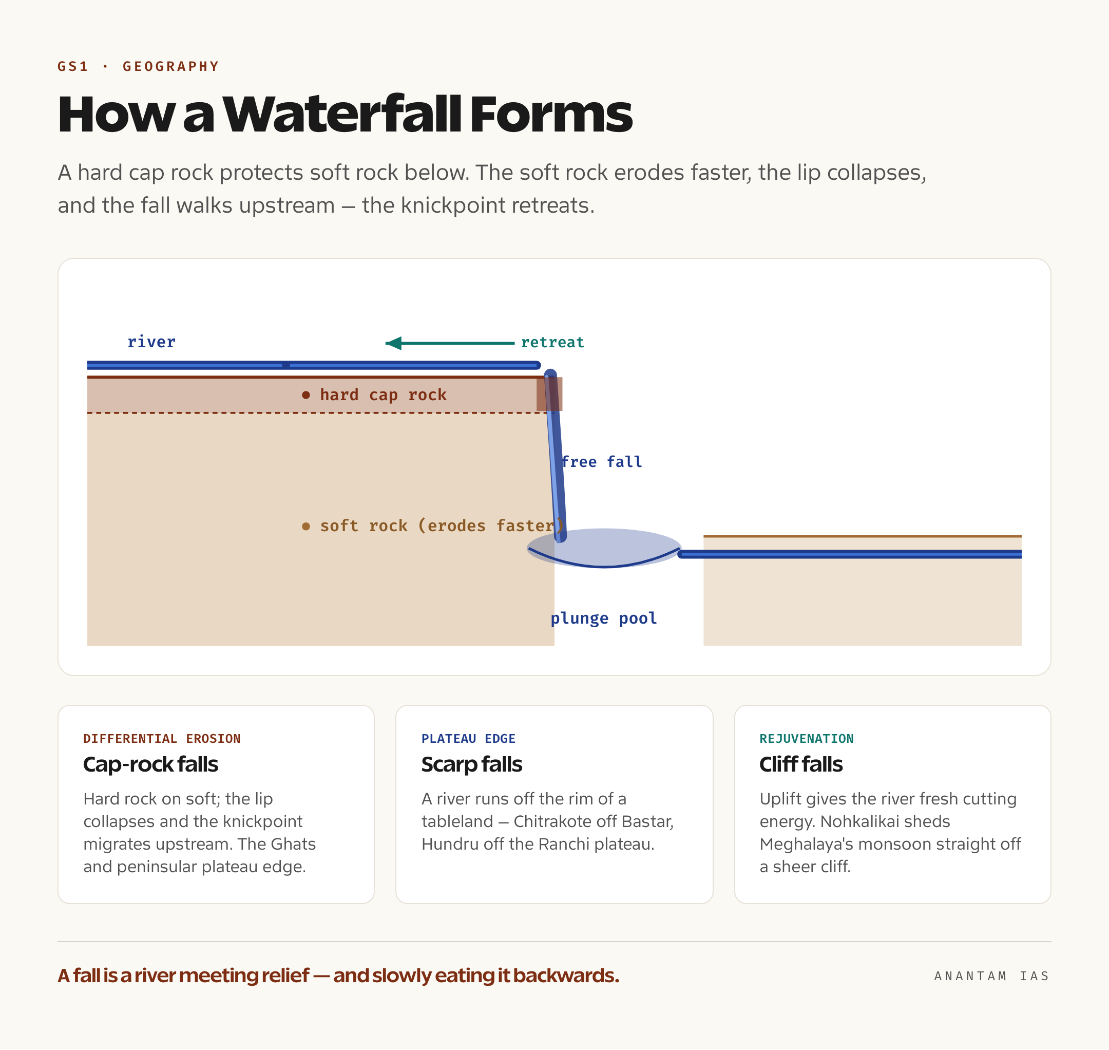
The classic textbook mechanism is differential erosion. A river crosses a layer of hard, resistant rock sitting on top of softer rock underneath. The soft rock gets scooped out faster, the hard rock is left jutting as a lip (a “cap rock”), and the water plunges off that lip into a deep plunge pool it has drilled below. Over centuries the falling water undercuts the soft rock, the unsupported hard lip collapses, and the whole waterfall slowly walks upstream. Geographers call this retreat the migration of a knickpoint, the sharp break of slope in a river’s long profile. This is the whole secret behind why India’s biggest falls cluster in two places: the edge of the peninsular plateau and the Western Ghats, where rivers tumble off old, hard Deccan basalt and Archaean rock onto lower ground.
Two more situations create falls in India. First, plateau-edge falls, where a river simply runs off the rim of a tableland (Chitrakote off the Bastar plateau, Hundru off the Ranchi plateau). Second, rejuvenation falls, where uplift gives a river fresh energy to cut down again, leaving a step in its course. The Meghalaya falls like Nohkalikai are a special case of this: a small, very wet plateau, soaked by the world’s heaviest monsoon rain, sheds water straight off a sheer cliff edge. If you’ve studied the peninsular plateau and the way the river systems of India drain west-to-east off the Ghats, the location of every major fall stops being a fact to memorise and becomes something you can almost predict.
The Highest Waterfall in India: Kunchikal vs Nohkalikai
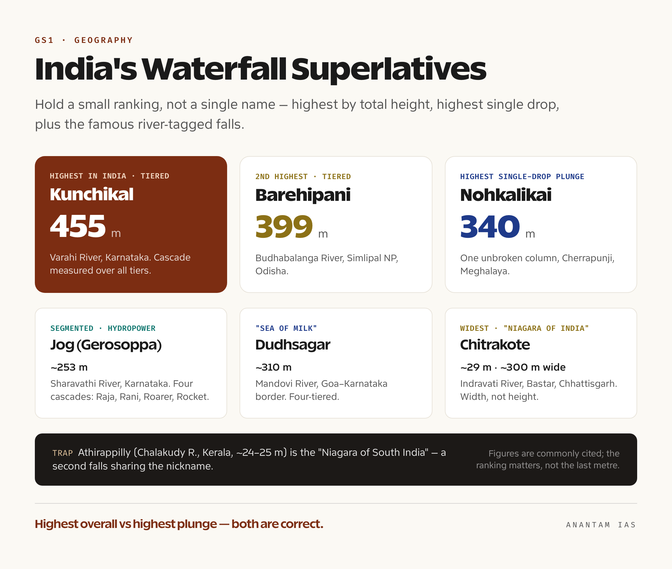
The highest waterfall in India is Kunchikal Falls in Karnataka, at about 455 metres (1,493 feet), but the highest single-drop or plunge waterfall is Nohkalikai Falls in Meghalaya, at about 340 metres (1,115 feet). Both statements are correct, and holding them together is the entire trick to this topic.
Here’s why both are true. Kunchikal, on the Varahi River near Masthikatte on the Shimoga-Udupi border, is a tiered or cascade waterfall, water dropping in a series of steps. Its 455 metres is the total fall measured over all those tiers, which is why it tops the height list. Honestly though, you’ll rarely see it at full glory, because the Mani Dam and an underground power station upstream now divert most of its water, so it flows only in the monsoon and sits inside a restricted zone needing a gate pass.
Nohkalikai, near Cherrapunji (Sohra) in the East Khasi Hills, drops in one clean, unbroken column off a plateau cliff. That makes it India’s highest plunge fall, water that free-falls without touching rock. The name means “the leap of Ka Likai” in Khasi, after a local legend, and below it sits a famously green plunge pool. Because it’s fed only by rain on a small plateau top, it’s at its thunderous best in the monsoon and thins to a ribbon by the February dry season.
There’s a third name worth knowing because exam-setters love it: Barehipani Falls in Odisha’s Simlipal National Park, on the Budhabalanga River, with a total height around 399 metres. Many lists call Barehipani the second-highest waterfall in India, sitting between Kunchikal and Nohkalikai. So the safe answer in your head should be a small ranking, not a single name: Kunchikal (highest, tiered) is first, Barehipani (second, tiered) next, and Nohkalikai is the highest among single-drop plunge falls. The numbers themselves shift a little across sources because nobody surveys these cliffs with the same instrument, so quote the commonly cited figures and don’t treat the last metre as gospel.
Why Heights Differ Across Sources
The disagreement is real and it’s not your textbook being sloppy. A tiered fall like Kunchikal can be measured as the sum of all tiers (giving the big 455 m figure) or as its largest single drop (much less). Monsoon swelling changes the visible drop, plunge pools shift, and many of these spots have never had a precise official survey. So when two trusted sources clash by a few metres, both are usually citing a defensible method. For an exam, lock in the commonly repeated number and the fact that the ranking, not the exact metre, is what gets tested.
Major Waterfalls of India by River and Region
The waterfalls that matter most for UPSC are the ones tied to a famous river or a famous nickname, because that’s what makes them examinable. Jog Falls is the one everyone pictures. On the Sharavathi River in Karnataka, it drops about 253 metres and splits into four named cascades, Raja, Rani, Roarer and Rocket, which is why it’s the textbook example of a segmented fall. It’s also a hydropower landmark, feeding the Mahatma Gandhi (Jog) hydroelectric station, so it doubles as a Geography and an Economy point.
Two falls share the nickname “Niagara of India,” and that overlap is a deliberate trap, so know both. Athirappilly Falls on the Chalakudy River in Thrissur, Kerala (around 24 to 25 metres) is the “Niagara of South India,” the largest in Kerala. Chitrakote Falls on the Indravati River in Bastar, Chhattisgarh (about 29 metres) earns the same nickname for a different reason: it’s the widest waterfall in India, spreading to nearly 300 metres in a horseshoe during the monsoon. Width, not height, is its claim.
The peninsular rivers give us the hydropower-heavy falls. Shivanasamudra Falls on the Cauvery in Karnataka is the classic, made of the Gaganachukki and Bharachukki segments, and home to one of Asia’s first hydroelectric stations, commissioned in 1902. The Krishna river and Cauvery dropping off the Deccan plateau is the same scarp-edge story playing out again. Up in the Chota Nagpur plateau, Hundru Falls drops the Subarnarekha about 98 metres off the Ranchi plateau, while central India’s Dhuandhar Falls on the Narmada at Bhedaghat (Jabalpur) is famous less for height (about 30 metres) than for the “smoke cascade” of spray that gives it its name, framed by marble gorges. Dudhsagar Falls (“sea of milk”) on the Mandovi River at the Goa-Karnataka border, around 310 metres over four tiers, rounds out the must-know peninsular set.
Complete List of Major Waterfalls in India
Use this as your one-stop revision table. Memorise the river and state first; the height is the tie-breaker the exam occasionally needs. Where sources disagree, the commonly cited figure is given.
| Waterfall | State | River | Height | Note |
|---|---|---|---|---|
| Kunchikal | Karnataka | Varahi | ~455 m | Highest in India (tiered/cascade) |
| Barehipani | Odisha | Budhabalanga | ~399 m | 2nd highest; in Simlipal NP |
| Nohkalikai | Meghalaya | (plateau stream) | ~340 m | Highest single-drop plunge in India |
| Dudhsagar | Goa-Karnataka | Mandovi | ~310 m | “Sea of milk”; four-tiered |
| Thalaiyar (Rat Tail) | Tamil Nadu | Manjalar | ~297 m | Highest in Tamil Nadu |
| Jog (Gerosoppa) | Karnataka | Sharavathi | ~253 m | Segmented (Raja, Rani, Roarer, Rocket); hydropower |
| Vantawng | Mizoram | Vanva | ~229 m | Highest in Mizoram |
| Langshiang | Meghalaya | Kynshi | ~337 m | Among India’s tallest by drop |
| Kynrem | Meghalaya | (Cherrapunji stream) | ~305 m | Three-tiered, near Sohra |
| Joranda | Odisha | Budhabalanga | ~150 m | Near Barehipani, Simlipal |
| Nuranang (Jang) | Arunachal Pradesh | Nuranang | ~100 m | Tawang district |
| Hundru | Jharkhand | Subarnarekha | ~98 m | Off the Ranchi plateau |
| Shivanasamudra | Karnataka | Cauvery | ~90-98 m | Gaganachukki + Bharachukki; 1902 power station |
| Chitrakote | Chhattisgarh | Indravati | ~29 m | Widest in India; “Niagara of India” |
| Athirappilly | Kerala | Chalakudy | ~24-25 m | Largest in Kerala; “Niagara of South India” |
| Dhuandhar | Madhya Pradesh | Narmada | ~30 m | Bhedaghat marble gorge; “smoke cascade” |
How to Study This for UPSC
Start with the rivers, not the falls. If you’ve already mapped India’s drainage, then “Sharavathi” should instantly trigger “Jog” and “Cauvery” should trigger “Shivanasamudra,” and you’ve turned a memory exercise into a reasoning one. Read the river systems of India and the Indian geography maps first, then come back to this list. That order saves you from rote-learning twenty random names.
For Prelims, the testable facts are narrow and predictable: highest waterfall (Kunchikal), highest plunge (Nohkalikai), widest (Chitrakote), the “Niagara of India” pair, and the river each major fall sits on. UPSC’s favourite format is a match-the-following or a “which river” single-statement question, so drill the river-state-height triplet for the top dozen and skip the long tail of minor falls. Don’t waste a week chasing every 40-metre cascade; the exam rewards the headline superlatives.
For Mains, waterfalls rarely appear on their own. They surface inside answers on hydropower potential (Sharavathi and Shivanasamudra are early hydroelectric sites, a clean line for any energy or peninsular-rivers question), on Western Ghats ecology (the Athirappilly hydel project versus river ecology is a live development-versus-environment example), and on tourism and regional development. So learn one or two falls deeply enough to deploy as examples, and let the rest stay as a recognition list. That’s the efficient split.
Frequently Asked Questions
Which is the highest waterfall in India? Kunchikal Falls in Karnataka, on the Varahi River, at about 455 metres, is the highest waterfall in India when measured by total height across its tiers. Nohkalikai in Meghalaya (about 340 metres) is the highest single-drop or plunge waterfall, so be clear which measure the question wants.
Which is the widest waterfall in India? Chitrakote Falls on the Indravati River in Chhattisgarh is the widest, spreading nearly 300 metres in a horseshoe during the monsoon. Its width, not its modest 29-metre height, is why it’s called the “Niagara of India.”
Why do different books give different heights for the same waterfall? Because tiered falls can be measured as a single drop or as the sum of all tiers, monsoon flow changes the visible drop, and many sites lack a precise official survey. Quote the commonly cited figure and remember the ranking matters more than the exact metre.
On which river is Jog Falls located? Jog Falls (also called Gerosoppa Falls) is on the Sharavathi River in Karnataka. It drops about 253 metres in four segments and feeds the Jog hydroelectric station, making it both a Geography and an Economy talking point.
Which waterfalls are linked to hydropower in India? Shivanasamudra on the Cauvery hosts one of Asia’s oldest hydroelectric stations (1902), and Jog Falls on the Sharavathi powers the Jog/Mahatma Gandhi hydel station. These are the two falls to cite in any answer on peninsular hydropower potential.
Practice Questions
Prelims MCQs
- Which of the following is the highest waterfall in India? (a) Jog Falls (b) Nohkalikai Falls (c) Kunchikal Falls (d) Dudhsagar Falls. Answer: (c) Kunchikal Falls in Karnataka (~455 m) is the highest by total height; Nohkalikai is highest only among single-drop plunge falls.
- The Shivanasamudra Falls are located on which river? (a) Sharavathi (b) Cauvery (c) Indravati (d) Mandovi. Answer: (b) Shivanasamudra is on the Cauvery and hosts one of Asia’s first hydroelectric stations (1902).
- Which waterfall is known as the widest in India and is often called the “Niagara of India”? (a) Athirappilly (b) Chitrakote (c) Barehipani (d) Hundru. Answer: (b) Chitrakote on the Indravati spreads nearly 300 m wide during the monsoon.
- Jog Falls is formed by which river? (a) Krishna (b) Tungabhadra (c) Sharavathi (d) Kali. Answer: (c) Jog (Gerosoppa) Falls is on the Sharavathi River in Karnataka and feeds the Jog hydroelectric station.
- Barehipani Falls, the second-highest waterfall in India, is located in which national park? (a) Kanger Valley (b) Simlipal (c) Nagarhole (d) Kaziranga. Answer: (b) Barehipani is in Simlipal National Park, Odisha, on the Budhabalanga River.
Mains Practice Questions
- Explain how the physiography of the peninsular plateau and the Western Ghats accounts for the distribution of India’s major waterfalls. (15 marks, 250 words)
- “India’s waterfalls are as much an economic resource as a scenic one.” Discuss with reference to hydropower development. (15 marks, 250 words)
- Examine the tension between hydroelectric projects and river ecology in the Western Ghats, using a specific waterfall as a case study. (15 marks, 250 words)
- Differentiate between plunge, tiered and segmented waterfalls, and explain the geological processes that produce them. (10 marks, 150 words)
- Discuss the role of waterfalls in regional tourism and balanced development in eastern and central India. (10 marks, 150 words)
The thing to walk away with is that you don’t need to fear this topic or over-prepare it. Anchor a dozen falls to their rivers, hold the two-measure ranking (highest overall versus highest plunge) in your head, and keep two hydropower examples ready for Mains. Do that, and a waterfall question becomes a free mark instead of a guess, which is exactly the kind of small, reliable win that adds up over a long preparation.