

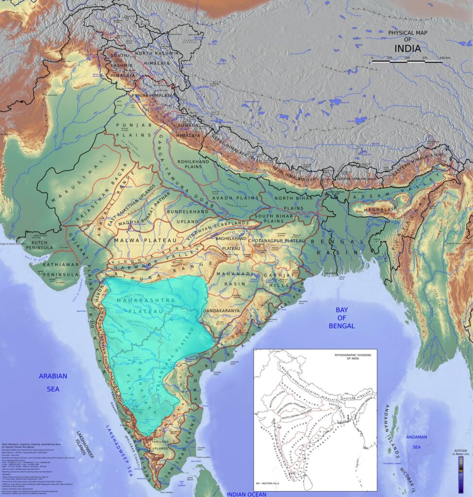
The Deccan Plateau is the great triangular tableland that occupies most of peninsular India south of the Narmada and Tapi valleys. Bounded by the Vindhya–Satpura ranges in the north, the Eastern Ghats along its eastern flank, and the Western Ghats along the west, the Deccan Plateau is one of the oldest stable landmasses on Earth, a fragment of the ancient Gondwana shield that began drifting northward more than 150 million years ago. Its volcanic foundation, lava-built topography, fertile black soils, and rich mineral reserves make the Deccan Plateau the single most important physiographic region for understanding peninsular India’s geology, agriculture, and economic geography. This explainer walks through the boundaries, regional divisions, geological history, soils, drainage, and resource base of the Deccan Plateau, with particular attention to the way the Deccan Traps episode shaped both the surface and the subsurface.
Geographical Boundaries and Extent
The Deccan Plateau covers roughly 1.9 million square kilometres, making it the largest plateau in India. Its northern apex is broadly anchored along the Vindhya Range and the Satpura mountain range, with the Narmada–Tapi rift valleys cutting across the northern edge. The two Ghat systems form the slanting flanks of the triangle: the Western Ghats rise sharply from the western edge near the Arabian Sea, while the Eastern Ghats run as a broken, discontinuous chain along the eastern margin. The southern tip of the triangle terminates near the Nilgiris, where the two Ghat systems meet.
The Deccan Plateau slopes gently from west to east. The Western Ghats average 900 to 1,500 metres in elevation, while the eastern edge falls to 300 to 600 metres before descending to the coastal plains of India. This west-to-east gradient explains why almost all the major peninsular rivers — the Godavari, Krishna, Kaveri, Pennar, and Mahanadi — flow eastward across the Deccan Plateau to drain into the Bay of Bengal. Only the Narmada and Tapi reverse this pattern, flowing westward through rift valleys.
Geological Origin of the Deccan Plateau
The Deccan Plateau rests on Archaean crystalline basement, but its present surface character is dominated by the Deccan Traps, one of the largest volcanic provinces in the world. Around 66 million years ago, at the Cretaceous–Paleogene boundary, a mantle plume erupted through the Indian plate as it drifted northward over the Réunion hotspot. The eruptions lasted for roughly one million years and produced flood basalts that originally covered more than 1.5 million square kilometres and reached thicknesses of over 2,000 metres in places.
Deccan Traps Basalt Stratigraphy
The Deccan Traps consist of horizontal lava flows stacked one above the other, each flow representing a single eruption episode separated by thin red soil layers called bole beds. The traps are subdivided stratigraphically into three groups — the Kalsubai, Lonavala, and Wai subgroups — and twelve formations based on chemical composition. The escarpments that result from the differential weathering of these flat-lying flows give the western Deccan Plateau its characteristic step-like profile (the word “trap” itself comes from the Swedish trappa, meaning “stair”).
The Deccan Traps eruption is also one of the leading suspects in the end-Cretaceous mass extinction debate. The sulphur dioxide and carbon dioxide released by the eruptions, combined with the Chicxulub asteroid impact, are believed to have triggered the climatic disturbances that wiped out the non-avian dinosaurs.
Pre-Trappean and Crystalline Cores
Not the entire Deccan Plateau is covered by basalt. The eastern and southern Deccan Plateau exposes the older crystalline rocks — granites, gneisses, and schists of the Dharwar and Cuddapah systems. These rocks are among the oldest on Earth, some dating back 3.5 billion years. The Karnataka Plateau, the Telangana plateau, and Rayalaseema sit on this ancient basement, while the Maharashtra Plateau lies directly on the Deccan Traps basalt.
Physiographic Divisions of the Deccan Plateau
The Deccan Plateau is conventionally divided into four major sub-regions, each with its own geology, climate, and resource character.
Maharashtra Plateau
The Maharashtra Plateau covers most of the modern state of Maharashtra and parts of north Karnataka and Madhya Pradesh. It is built almost entirely on Deccan Traps basalt and is characterised by flat-topped hills, mesa and butte landforms, and deep, fertile black cotton soils. The Sahyadri (Western Ghats) edge gives way eastward to undulating tablelands drained by the Godavari, Bhima, and upper Krishna. Major plateau surfaces include the Ajanta-Satmala range, the Balaghat range, and the Mahadeo Hills.
Karnataka Plateau
The Karnataka Plateau extends across most of Karnataka south of the Tungabhadra. It is built on Precambrian crystalline rocks of the Dharwar craton. The plateau is divided into two sections by altitude: the higher Malnad in the west, with average elevations of 800 to 1,000 metres and heavy monsoon rainfall on the Western Ghats flank, and the lower Maidan in the east, gently sloping toward the Eastern Ghats. Bangalore, Mysuru, and Hassan all sit on the Maidan section.
Telangana Plateau
The Telangana plateau covers the present state of Telangana between the Godavari and Krishna basins. Like the Karnataka Plateau, it rests on Archaean granites and gneisses, but it also contains important Gondwana sedimentary basins (the Pranhita–Godavari graben) that host coal deposits. Average elevations range from 500 to 800 metres. The plateau is drained by the Godavari and Krishna and their major tributaries — the Manjira, the Musi, and the Krishna’s distributaries.
Rayalaseema and the Southern Deccan
Rayalaseema occupies the southern part of Andhra Pradesh and is geologically distinct, sitting on the Cuddapah Basin sediments and Eastern Ghats crystallines. It is generally drier than the rest of the Deccan Plateau because of its position in the rain shadow of the Western Ghats, and it includes the Erramala, Nallamala, and Velikonda ranges of the Eastern Ghats. Hyderabad sits at the junction of the Telangana plateau and Rayalaseema.
Soils of the Deccan Plateau
The most distinctive soil of the Deccan Plateau is the black cotton soil, locally called regur. It develops directly on weathered Deccan Traps basalt and covers roughly 5.5 lakh square kilometres in Maharashtra, Madhya Pradesh, Gujarat, and northern Karnataka. Black cotton soil is rich in iron, lime, magnesium, and aluminium, with a high clay content that gives it remarkable moisture-holding capacity. This makes the soil ideally suited for rain-fed cotton cultivation, from which it draws its English name, and for crops like jowar, pulses, and groundnut.
Drainage Pattern of the Deccan Plateau
The drainage of the Deccan Plateau is dominated by the eastward-flowing peninsular rivers. The Godavari is the largest, rising in the Trimbak Hills of the Western Ghats and draining nearly one-tenth of India’s area before emptying into the Bay of Bengal. The Krishna follows a similar east-flowing course, as do the Kaveri, Pennar, and Mahanadi. These rivers have cut deep gorges through the older basement rocks and broad floodplains across the eastern Deccan Plateau.
The drainage is largely consequent and old. Most peninsular rivers follow valleys that have existed since the Mesozoic. The Western Ghats act as the master watershed of the peninsula. The Narmada and Tapi are exceptions: both flow westward through rift valleys produced by the same tectonic processes that opened the Arabian Sea. The combination of hard crystalline rocks and gentle gradients means that the rivers of the Deccan Plateau have relatively few large natural lakes; reservoirs created behind dams like Hirakud, Nagarjuna Sagar, and Srisailam dominate the modern hydrological picture.
Mineral Wealth of the Deccan Plateau
The Deccan Plateau is one of India’s most important mineral-bearing regions. The Dharwar and Cuddapah crystalline rocks of the Karnataka Plateau and Rayalaseema contain some of the country’s largest reserves of iron ore (Ballari–Hosapete), manganese, gold (Kolar and Hutti), chromite, and bauxite. The Telangana plateau hosts the Singareni coalfield in the Pranhita–Godavari Gondwana basin, the only major coal-producing region in peninsular India. The Deccan Traps themselves yield very few metallic minerals but are extensively quarried for building stone and road metal.
Climate, Vegetation, and Agriculture
The Deccan Plateau lies in the rain shadow of the Western Ghats. Average annual rainfall ranges from 600 to 1,000 millimetres, decreasing eastward and southward into Rayalaseema, where some districts receive less than 500 mm. The monsoon is shorter and more erratic than on the coasts. Natural vegetation is dominated by tropical dry deciduous forests, with teak, sal, mahua, and bamboo as the principal species. The Deccan Plateau is the heartland of rain-fed agriculture in India, supporting cotton, jowar, bajra, pulses, oilseeds, and groundnut. Irrigated tracts along the major rivers grow paddy, sugarcane, and tobacco.
Strategic and Cultural Significance
The Deccan Plateau has been a cradle of major South Indian polities for over two millennia, from the Satavahanas and the Vakatakas to the Chalukyas, the Rashtrakutas, the Vijayanagara empire, and the Bahmani sultanates. Its uplands offered natural defensive positions; its mineral wealth funded its kingdoms; and its position between the two Ghat systems made it a corridor between the eastern and western coasts of the peninsula. Modern industrial centres like Pune, Hyderabad, Bangalore, and Nagpur all owe their growth in part to the resource base and stable geology of the Deccan Plateau.
Frequently Asked Questions
What is the Deccan Plateau and where is it located?
The Deccan Plateau is a large triangular tableland covering most of peninsular India south of the Narmada. It is bordered by the Vindhya and Satpura ranges in the north, the Western Ghats on the west, and the Eastern Ghats on the east. It covers roughly 1.9 million square kilometres across Maharashtra, Karnataka, Telangana, Andhra Pradesh, and parts of Madhya Pradesh and Tamil Nadu.
How was the Deccan Plateau formed geologically?
The Deccan Plateau rests on Archaean crystalline basement but its surface is dominated by the Deccan Traps, flood basalts erupted around 66 million years ago at the Cretaceous–Paleogene boundary. The eruptions occurred as the Indian plate drifted over the Réunion hotspot and produced lava flows that originally covered over 1.5 million square kilometres.
What are the main physiographic divisions of the Deccan Plateau?
The Deccan Plateau is divided into the Maharashtra Plateau (built on Deccan Traps basalt), the Karnataka Plateau (Dharwar crystallines, with the Malnad and Maidan sub-regions), the Telangana plateau (granite-gneiss with Gondwana coal basins), and Rayalaseema in southern Andhra Pradesh (on Cuddapah and Eastern Ghats rocks).
What is black cotton soil and why is it associated with the Deccan Plateau?
Black cotton soil, or regur, forms directly on weathered Deccan Traps basalt. It is rich in iron, lime, and magnesium, with a high clay content that gives it strong moisture-retention. This makes it especially suitable for rain-fed cotton, jowar, pulses, and oilseed cultivation, which is why it dominates the agriculture of the Maharashtra Plateau and adjoining regions.
Why do most rivers of the Deccan Plateau flow eastward?
The Deccan Plateau slopes gently from west to east because the Western Ghats are higher than the Eastern Ghats. As a result, almost all the major peninsular rivers — Godavari, Krishna, Kaveri, Pennar, and Mahanadi — flow eastward and drain into the Bay of Bengal. The Narmada and Tapi are exceptions and flow westward through rift valleys.
What are the major minerals found on the Deccan Plateau?
The Deccan Plateau hosts large reserves of iron ore (Ballari–Hosapete), manganese, gold (Kolar and Hutti), bauxite, chromite, and limestone in its older crystalline regions, and coal in the Singareni field of the Pranhita–Godavari Gondwana basin in Telangana. The Deccan Traps themselves are mostly quarried for building stone and road metal.
How does the Deccan Plateau differ from the Chota Nagpur Plateau?
The Deccan Plateau covers most of peninsular India and is built mostly on Deccan Traps basalt and Dharwar crystallines. The Chota Nagpur Plateau, by contrast, is a smaller plateau in eastern India centred on Jharkhand, dominated by Archaean granite-gneiss, and far richer in coal, iron, and other industrial minerals on a per-unit-area basis.
Why is the Deccan Plateau considered stable in geological terms?
The Deccan Plateau is part of the Indian craton, one of the oldest and most stable continental blocks on Earth. It has not experienced major tectonic deformation since the Deccan Traps eruption ended around 65 million years ago. The Koyna region is the only significant zone of contemporary seismicity, and that is linked to reservoir-induced stresses rather than to active plate boundaries.
Tell Google you want more of this.
Add Anantam IAS as a preferred sourceOne tap, and this site shows up more often in your own Top Stories, AI Overviews and AI Mode. Remove it any time.






