Detection Technologies: RADAR, SONAR, LIDAR, AESA and Their Defence and Civilian Uses
Detection technologies for UPSC: how RADAR uses radio waves, SONAR uses sound, and LIDAR uses laser pulses; their relative strengths in air, water and short-range mapping; AESA, doppler radar, synthetic aperture radar; and their roles in S-400, submarines, self-driving cars and weather monitoring.
A defence force or a self-driving car has the same basic problem. Something is out there, and it needs to be detected, located and tracked, often in conditions where the eye cannot see. The solution is to send out a wave, listen for the echo, and calculate where the reflection came from. The choice of wave determines almost everything. Radio waves go far through cloud and rain. Sound waves are the only ones that travel well underwater. Laser light returns extraordinary three-dimensional detail at short range but stops at fog. Each detection technology is shaped by the physics of its wave.
For UPSC, detection technologies appear in GS-III science and technology and in GS-III internal security. The S-400 air defence system, the AWACS aircraft, the AESA radars on Tejas and Rafale, the SONAR on Indian submarines, the doppler radars of the IMD, and the LIDAR units on autonomous cars and lunar rovers are all built on these basic principles. The exam often asks how they work, where they are deployed, and how India’s domestic capability is developing.
This explainer compares RADAR, SONAR and LIDAR, walks through the key variants like AESA and synthetic aperture radar, and maps where each technology is used in India.
Quick Facts: Detection Technologies at a Glance
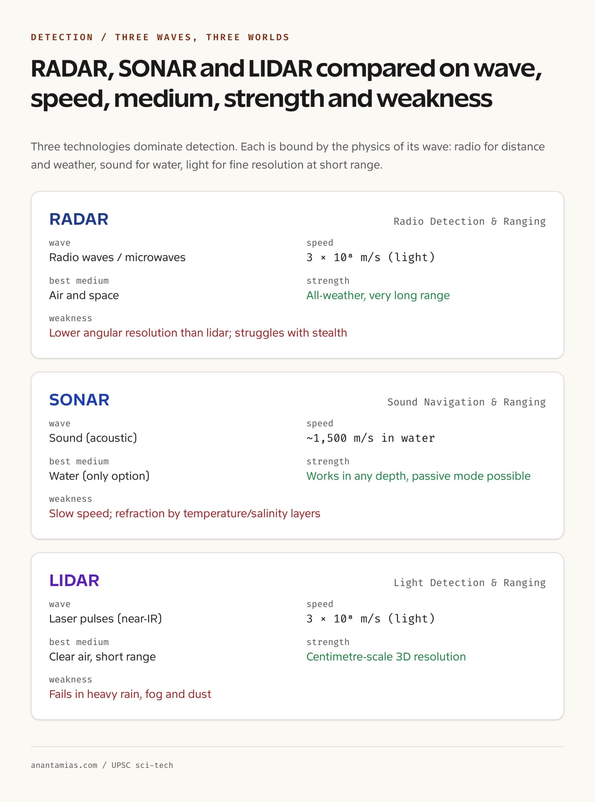
- RADAR: Radio Detection and Ranging, uses radio waves or microwaves, travels at the speed of light
- SONAR: Sound Navigation and Ranging, uses acoustic waves, travels at about 1,500 m/s in water
- LIDAR: Light Detection and Ranging, uses laser pulses (often near-infrared), travels at the speed of light
- Best medium: RADAR for air and space, SONAR for water, LIDAR for short-range air mapping
- All-weather capability: RADAR works through rain, fog and cloud; LIDAR is degraded by them
- Resolution ranking: LIDAR (highest) > RADAR > SONAR (in their respective domains)
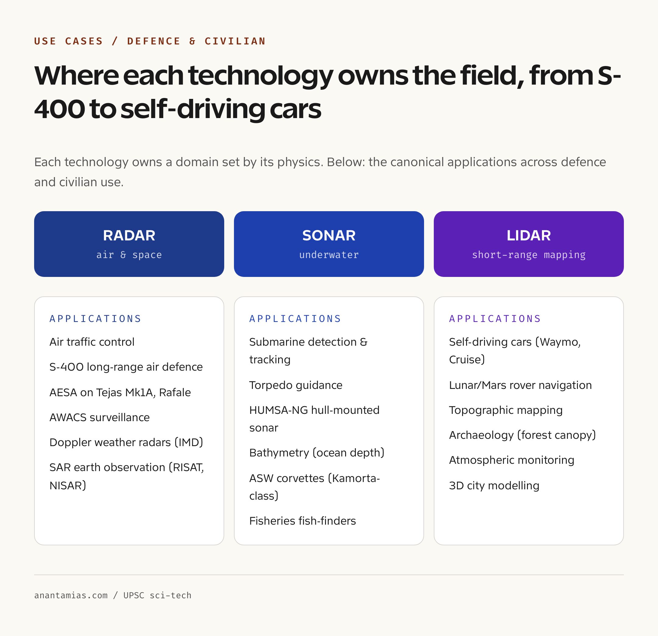
- Military deployments: RADAR on S-400, Akash, Tejas (AESA), AWACS; SONAR on submarines and ASW ships
- Civilian uses: Doppler radar for IMD weather, LIDAR for self-driving cars and ISRO lunar mapping
- India indigenous radar: DRDO Uttam AESA on Tejas Mk1A; Rohini, Revathi and Aslesha series
What Are Detection Technologies?
A detection technology is any system that emits a signal, waits for the signal to bounce off an object, and uses the returning echo to compute where that object is, how fast it is moving, and sometimes what it is. The basic geometry is the same across radar, sonar and lidar. The system measures the time of flight from emission to return, multiplies by the wave speed, and divides by two to get the range to the target. The direction is determined by the orientation of the antenna or transducer. The velocity is computed from the doppler shift, the small change in frequency caused by the target’s motion.
Beyond this shared geometry, each technology differs in three ways. The wave used has a particular speed, wavelength and propagation behaviour, and these properties determine how far it goes, what materials it penetrates, and how fine a detail it can resolve. The medium in which the wave travels well is different: radio waves travel beautifully through air and space, sound waves travel well through water, light waves travel well through clear air over short distances. The hardware needed to generate and receive each wave is also different, which makes specialised equipment for each.
The “best” technology is whichever one matches the medium and the application. Pilots use radar. Submariners use sonar. Self-driving cars and lunar rovers use lidar. There is no general-purpose solution.
Background and Historical Context
The development of detection technology is one of the great stories of twentieth-century science and warfare. Christian Hulsmeyer demonstrated a primitive radio echo device in Germany in 1904, but the technology lay dormant for decades. The strategic breakthrough came in the late 1930s as several countries, including Britain, Germany and the United States, raced to develop radio detection systems for air defence. Robert Watson-Watt’s Chain Home network, deployed along the British coast from 1936, gave the Royal Air Force critical warning during the Battle of Britain in 1940. The Massachusetts Institute of Technology Radiation Laboratory, established in 1940, drove an explosion of radar research that produced microwave radar, airborne radar and the first ground-controlled approach systems for civil aviation.
Sonar, in its modern form, was driven by the submarine threat in both world wars. Paul Langevin in France developed the first piezoelectric ultrasonic transducers during the First World War, and the British produced an active sonar system, code-named ASDIC, by 1918. The Second World War saw active and passive sonar mature into the central anti-submarine technologies. Today’s military sonars range from hull-mounted active arrays on warships to towed line arrays many kilometres long behind submarines.
Lidar emerged later, after the laser was invented in 1960. Early uses were in atmospheric science, where laser pulses sent into the sky returned data on aerosols and pollution. The 1971 Apollo 15 mission carried a laser altimeter that mapped the lunar surface. The technology took off commercially in the 2000s as automotive companies began to integrate it into self-driving prototypes and as airborne lidar became standard for topographic mapping. India’s Chandrayaan missions have carried laser ranging instruments, and the Mars and Moon rovers globally rely on lidar for terrain awareness. For broader context on adjacent science and tech areas, see our pieces on ISRO missions, space technology and internal security.
RADAR (Radio Detection and Ranging)
A radar transmits radio-frequency or microwave pulses through an antenna, listens for the echoes returned by objects in its beam, and measures the time delay to compute range. The frequency band determines the trade-off between range and resolution. Lower-frequency, longer-wavelength radars (like L-band and VHF) travel farther and can detect stealth aircraft better, but they have poor resolution. Higher-frequency, shorter-wavelength radars (like X-band and Ku-band) give finer detail but are absorbed more by atmospheric moisture.
The biggest advantage of radar is all-weather capability. Radio waves penetrate cloud, rain and fog with relatively little loss, which is why radar is the workhorse of air defence and air traffic control. The biggest weakness is resolution. A radar can detect that something the size of an aircraft is at a particular bearing and range, but it cannot, by itself, see the aircraft’s shape clearly. Specialised techniques such as inverse synthetic aperture radar can build images, but conventional radar gives a blip on a screen.
Variants are important. Doppler radar uses the doppler shift in the returned signal to compute target velocity, which is essential for tracking moving targets and for weather radars that detect wind in storm cells. Synthetic Aperture Radar (SAR) is mounted on aircraft or satellites; as the platform moves, successive radar pulses are combined to synthesise a much larger antenna and produce high-resolution images of the surface, day or night, through cloud. India’s RISAT and the upcoming NISAR satellite use SAR. AESA, or Active Electronically Scanned Array, uses many small transmit-receive modules to steer the beam electronically rather than mechanically. AESA radars can scan faster, track many targets simultaneously, and resist jamming better than older radars. The DRDO Uttam AESA radar is being integrated into the Tejas Mk1A.
SONAR (Sound Navigation and Ranging)
Sonar uses acoustic waves rather than electromagnetic waves, because radio waves do not travel well through water but sound does. Active sonar transmits a sound pulse and listens for echoes, exactly like radar. Passive sonar listens for sounds emitted by other sources, such as the noise of an enemy submarine’s propeller or machinery, without transmitting anything itself. Passive sonar gives away no position; active sonar reveals the searcher.
The speed of sound in water is roughly 1,500 metres per second, far slower than the speed of light. This makes sonar’s range computations slower than radar’s but no less accurate. The range achievable depends heavily on water conditions. Temperature, salinity and depth create acoustic layers that bend sound rays, sometimes refracting them away from a target and sometimes channelling them over very long distances in deep ocean sound channels.
Submarines use both active and passive sonar in distinct tactical contexts. Hull-mounted arrays detect short-range threats. Bow-mounted spherical arrays give wide-angle search. Towed line arrays, deployed kilometres behind the submarine, give the longest-range passive detection by exploiting low-frequency sounds that travel best. Anti-submarine warfare ships and helicopters use dipping sonars and sonobuoys. The Indian Navy operates these capabilities on its Kilo, Scorpene and Arihant-class submarines and its Kamorta-class anti-submarine corvettes.
LIDAR (Light Detection and Ranging)
Lidar uses pulsed laser light, typically near-infrared, and measures time of flight to compute range. The wavelength is much shorter than radar’s, which gives lidar dramatically higher angular resolution. A modern automotive lidar can resolve objects to a few centimetres at 100 metres, far finer than any radar of comparable size.
The trade-off is range and weather. Lidar pulses are scattered and absorbed by water droplets, ice crystals and dust, which makes lidar weak in fog, heavy rain and snow. Useful range is typically up to about 200 metres for automotive systems, with longer ranges achievable for airborne and satellite systems pointing at solid surfaces.
Applications are in three main domains. Autonomous vehicles use lidar to build a 360-degree three-dimensional point cloud of the surroundings, allowing precise detection of pedestrians, lane markings and obstacles. The technology is used by Waymo, Cruise and many others, although Tesla controversially relies on cameras alone. Topographic mapping by aircraft-mounted lidar produces high-resolution digital elevation models that can see through forest canopy by exploiting laser pulses that pass between leaves. This has revolutionised archaeology, particularly in Central American jungles where lidar surveys have revealed entire Maya cities under vegetation. Space exploration uses lidar for terrain mapping on the Moon and Mars; the Chandrayaan-2 orbiter carried a laser altimeter, and rovers use lidar for navigation.
Comparative Strengths and Weaknesses
Each technology occupies a distinct niche set by physics. Radar is the only choice for very long range, all-weather operation in the air and in space. Sonar is the only choice underwater. Lidar is the only choice when you need three-dimensional point clouds with centimetre resolution at short range.
Resolution ranking, in their respective domains: lidar (centimetres) > radar (metres to tens of metres for conventional systems, finer with SAR) > sonar (metres to tens of metres). Range ranking: long-range radar can reach hundreds of kilometres; sonar in deep ocean channels can reach hundreds of kilometres for low frequencies; lidar is typically limited to hundreds of metres. Weather tolerance: radar is best (penetrates rain, fog, cloud); sonar is unaffected by atmosphere because it operates in water; lidar is worst because optical wavelengths scatter in moisture and dust.
Cost and size also differ. A small automotive radar costs a few hundred dollars. A military AESA radar costs millions. A high-end automotive lidar still costs thousands. A submarine sonar suite costs tens of millions. The decision among the technologies depends not just on technical fit but on what an application can pay.
Indian Deployment
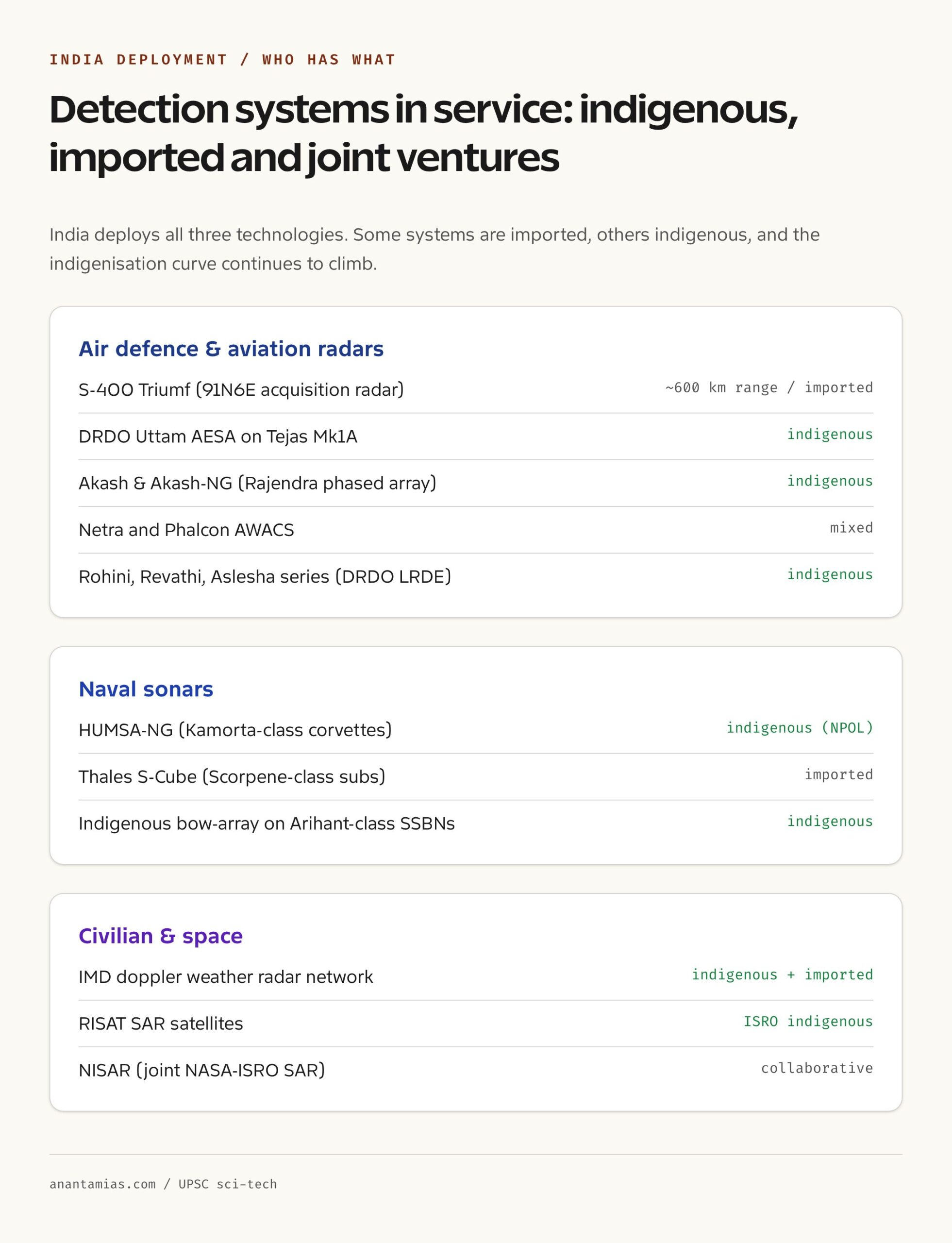
India deploys all three technologies across defence and civilian applications. In air defence, the S-400 system uses long-range and target-tracking radars, with the 91N6E acquisition radar reaching 600 kilometres. The Akash and Akash-NG missile systems use Rajendra and similar phased-array radars. The Tejas Mk1A is being equipped with the indigenous DRDO Uttam AESA radar, while the Rafale and Su-30 MKI carry French and Russian radars respectively. The Netra and Phalcon AWACS aircraft carry rotodome radars for surveillance.
In maritime applications, Indian Navy submarines use a mix of imported and indigenous sonar suites. The Scorpene-class Kalvari submarines use the Thales S-Cube. The Kamorta-class corvettes carry the indigenous HUMSA-NG hull-mounted sonar developed by the Naval Physical and Oceanographic Laboratory. The Indian Coast Guard uses surface-search radars on its patrol vessels.
In civilian applications, the India Meteorological Department operates a network of doppler weather radars across the country for cyclone and rainfall tracking. ISRO’s RISAT satellites and the upcoming joint NASA-ISRO NISAR satellite use SAR for earth observation. Lidar is used on Indian roads in research projects on autonomous mobility, and ISRO’s lunar missions have carried laser altimeters.
Challenges
The challenges across all three technologies are similar. Detection systems are in a constant arms race with countermeasures. Stealth aircraft are designed to absorb radar waves. Acoustic quieting on modern submarines makes them hard to detect by passive sonar. Adverse weather degrades lidar. Each generation of detection requires investment in new physics and new manufacturing.
For India specifically, the gap between research and production remains. The Uttam AESA, while a major achievement, took longer than planned to integrate with the Tejas. Submarine sonar arrays are still partly imported. The components inside radars, particularly gallium nitride transmit-receive modules, are produced abroad. Indigenisation has progressed but is incomplete.
Cost and lifecycle support are also issues. The S-400 was bought from Russia under a contract whose continuation has become more complex with sanctions and supply-chain disruption. Long-term sustainment of imported systems is a strategic vulnerability that domestic alternatives can address only over time.
UPSC Prelims Pointers
- RADAR uses radio waves; SONAR uses sound; LIDAR uses laser light
- Radar and lidar travel at the speed of light; sonar at about 1,500 m/s in water
- Radar is best for air and space; sonar for underwater; lidar for short-range mapping
- Radar penetrates rain, fog and cloud; lidar does not
- LIDAR has the highest resolution among the three
- Doppler radar measures velocity from frequency shift, used by IMD for cyclones
- AESA = Active Electronically Scanned Array; DRDO’s Uttam AESA is on Tejas Mk1A
- SAR = Synthetic Aperture Radar, used on RISAT and the upcoming NISAR satellite
- S-400 has the 91N6E radar with around 600 km range
- HUMSA-NG is an indigenous Indian Navy hull-mounted sonar from NPOL
- LIDAR is used in self-driving cars, archaeology and lunar rover navigation
UPSC Mains Practice Questions
- Distinguish between RADAR, SONAR and LIDAR in terms of physical principle, medium of operation, and applications. Give Indian examples of each.
- Examine the role of detection technologies in modern Indian air defence. What gaps exist in India’s indigenous capability and how are they being addressed?
- “Detection technologies are in a permanent arms race with countermeasures.” Discuss with reference to stealth aircraft, submarine quieting and electronic countermeasures.
- Discuss the civilian applications of synthetic aperture radar (SAR) and lidar. How do these technologies contribute to weather forecasting, disaster management and natural-resource mapping in India?
Way Forward
India’s path on detection technology runs along three tracks. First, indigenous R&D and production should accelerate, with DRDO’s Uttam AESA, the NPOL sonar suites, and the LRDE long-range radars given clear pathways to volume manufacture. The recent emphasis on a domestic gallium nitride supply chain is the right direction. Second, integration with imported systems should be planned with future indigenisation in mind, so that critical components can be replaced over time without compromising operational readiness. Third, civilian applications, particularly weather radar networks, satellite SAR coverage and disaster-management lidar surveys, should be expanded as part of climate-resilient infrastructure. The detection systems that protect a coastline from a cyclone are no less critical than those that protect it from intrusion.
For students, the core takeaway is that detection technology is physics applied to a problem. The wave, the medium, the geometry. Once those three are clear, the system architecture follows. Memorising names is less useful than understanding why a submarine cannot use radar and a fighter pilot cannot use sonar.
Frequently Asked Questions
What is the main difference between RADAR, SONAR and LIDAR?
The main difference is the type of wave each uses. RADAR uses radio waves or microwaves, SONAR uses sound waves (acoustic), and LIDAR uses laser light. Radar and lidar both travel at the speed of light because they are electromagnetic; sonar travels at the speed of sound, which is much slower in water (about 1,500 m/s). The choice of wave determines what medium the technology works in.
Why do submarines use SONAR and not RADAR?
Radio waves do not travel well through water; they are absorbed within metres. Sound waves, on the other hand, travel for kilometres in water, which is why marine mammals communicate by sound and why submarines and surface warships use sonar. Radar, by contrast, travels well in air and space and is unaffected by cloud, which makes it ideal for aircraft detection but useless for underwater work.
What is AESA radar?
AESA stands for Active Electronically Scanned Array. Instead of a single transmitter and a mechanically rotating antenna, an AESA radar uses many small transmit-receive modules arranged in a flat panel. The beam is steered electronically by adjusting the phase of each module. This allows much faster scanning, simultaneous tracking of many targets, and stronger resistance to jamming. India’s DRDO has developed the Uttam AESA radar, which is being integrated with the Tejas Mk1A fighter.
What is doppler radar used for?
Doppler radar measures both the range to a target and its velocity, by exploiting the doppler shift in the returned signal. The most familiar civilian use is in weather forecasting, where doppler weather radars track winds inside storm cells and detect cyclonic rotation. The India Meteorological Department operates a network of doppler weather radars for cyclone and severe-weather warning.
What is synthetic aperture radar (SAR)?
Synthetic Aperture Radar is a technique used on moving platforms like aircraft and satellites. As the platform moves along its track, successive radar pulses are combined coherently to synthesise the effect of a much larger antenna than the physical hardware. This produces high-resolution radar images of the surface, day or night, through cloud and rain. India’s RISAT satellites and the upcoming joint India-US NISAR satellite use SAR.
Why is LIDAR used in self-driving cars?
Lidar produces a high-resolution three-dimensional point cloud of the vehicle’s surroundings, allowing precise detection of pedestrians, lane markings, parked cars and obstacles to within a few centimetres. This complements cameras and radars, which have different strengths. Lidar’s main weaknesses are cost and degradation in heavy rain or fog. Some autonomous vehicle developers like Waymo and Cruise rely heavily on lidar; Tesla notably does not.
What detection systems does the S-400 use?
The S-400 air defence system uses several radars working together. The 91N6E u0022Big Birdu0022 is the long-range acquisition radar with a range of about 600 km. The 96L6E u0022Cheese Boardu0022 is an all-altitude target detector. Engagement radars guide the missiles to specific targets. Together they allow detection, tracking and engagement of aircraft, cruise missiles and some ballistic missiles at long range.
Is India self-sufficient in detection technology?
India has made significant progress but is not fully self-sufficient. DRDO has developed indigenous radars including the Uttam AESA, the Rohini and Revathi series, and the Aslesha low-level radar. NPOL has developed indigenous sonars like HUMSA-NG. However, several key components such as gallium nitride transmit-receive modules and high-end signal processors are still imported. Major systems like the S-400 remain Russian, and integration support depends on foreign partners. The trajectory is towards greater indigenisation, but it is incomplete.
Can RADAR detect stealth aircraft?
Stealth aircraft are designed to absorb and deflect radar waves, making their radar cross-section much smaller than a conventional aircraft of the same size. Standard radars struggle to detect them at long range. However, lower-frequency radars in the VHF and UHF bands can sometimes pick up stealth aircraft because the radar wavelength becomes comparable to the size of the aircraft’s features. Networked radar systems and infrared search and track (IRST) sensors are also used to compensate.