EOS-08 Earth Observation Satellite: Payloads, Microsat-2C, and ISRO’s New Satellite Bus
A complete UPSC GS-III explainer on EOS-08. Covers the satellite, the SSLV launch, the EOIR, GNSS-R, and SiC UV dosimeter payloads, ISRO's Microsat-2C platform, and applications in defence, climate, and disaster management.
EOS-08, also known as Microsat-2C, is one of the more revealing satellites ISRO has launched in recent years. Not because it carries headline-grabbing instruments. The whole satellite weighs only 175.5 kilogrammes. But because it tests a long list of new ISRO technologies in one mission, demonstrates a new launch vehicle in operational service, and validates a payload mix that links Earth observation, navigation reflectometry, and space-environment monitoring in a single small bus.
The satellite was launched on 16 August 2024 from Sriharikota aboard the SSLV-D3, the third developmental flight of the Small Satellite Launch Vehicle. EOS-08 was the primary payload, paired with a small student satellite SR-0 DEMOSAT. Both were placed in a low Earth orbit at around 475 kilometres altitude with an inclination of 37.4 degrees, an unusual choice for an Indian Earth observation satellite that signals the operational interest in tropical-zone coverage.
For UPSC GS-III, EOS-08 sits at the intersection of space technology, defence preparedness, climate monitoring, and the commercialisation of small-satellite launch capability. This article walks through what EOS-08 carries, how it fits into ISRO’s Earth-observation chain, the technologies it demonstrated, and the strategic context.
Quick Facts on EOS-08
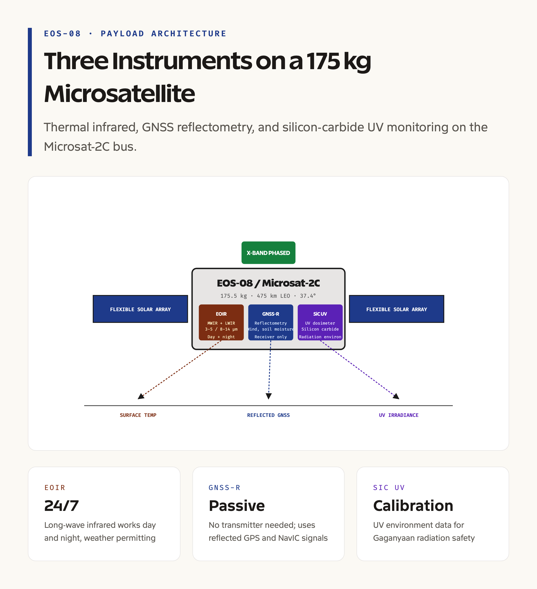
EOS-08 is the eighth satellite in ISRO’s renamed Earth Observation Satellite series, a numbering scheme that replaced the older Cartosat, Resourcesat, and Oceansat naming convention from 2020 onward. The platform is the Microsat-2C bus, a new ISRO microsatellite frame derived from the IMS-1 lineage but with significant upgrades for power, attitude control, and data handling.
The launch mass is 175.5 kilogrammes. The orbit is a low Earth circular orbit at approximately 475 km altitude with 37.4 degree inclination. The mission life is one year, which is shorter than ISRO’s typical Earth-observation satellites because the orbit at 475 km decays faster due to atmospheric drag. The satellite is stabilised in three axes using reaction wheels and magnetic torquers, with payload pointing accuracy on the order of arc seconds.
The launch vehicle is the SSLV-D3, the third developmental flight of the Small Satellite Launch Vehicle. SSLV is a three-stage solid-propellant rocket designed for launches up to 500 kilogrammes to a 500 km LEO. The D3 mission was the first SSLV flight to fully meet all mission objectives after the partial success of D1 and D2, marking the operational debut of the vehicle.
The Three Payloads of EOS-08
EOS-08 carries three payloads with very different scientific and operational purposes.
The Electro Optical Infrared Payload, abbreviated EOIR, is the primary imaging instrument. It captures images in the Mid-Wave Infrared band, around 3 to 5 micrometres, and the Long-Wave Infrared band, around 8 to 14 micrometres. These bands capture thermal emission from the Earth’s surface and atmosphere, allowing observation of fires, hot industrial activity, and surface temperature gradients. Long-wave infrared is also the primary band for thermal mapping of urban heat islands, agricultural drought stress, and ocean surface temperature.
EOIR’s spatial resolution is in the tens of metres, which is moderate by current standards but useful for thermal monitoring where signal strength matters more than fine detail. The payload runs day and night, since infrared imaging does not depend on solar illumination. This 24-hour capability is operationally important for defence reconnaissance and forest-fire monitoring.
The GNSS Reflectometry payload, abbreviated GNSS-R, is the more innovative instrument. It does not transmit anything. It receives navigation signals from GPS, NavIC, and other constellations after they have reflected off the Earth’s surface, and uses the reflected signal characteristics to derive geophysical parameters. We cover NavIC in detail in our NavIC vs GPS comparison.
GNSS-R is a relatively new technique that provides ocean surface wind speed and direction, soil moisture content, snow and ice properties, and flood extent. The signal-to-noise ratio of reflected GNSS signals is lower than dedicated radar instruments, but the technique has the major advantage of needing no transmitter, which means low power, low mass, and continuous global coverage from any satellite that flies a receiver.
The SiC UV Dosimeter is the third payload. It uses silicon carbide-based detectors to measure ultraviolet irradiance in low Earth orbit. The data calibrates UV measurements for future Indian human spaceflight, supports radiation environment monitoring for crewed missions like Gaganyaan, and provides input for UV-driven atmospheric chemistry models.
The Microsat-2C Platform and Technology Demonstrations
EOS-08 was as much a technology testbed as an Earth-observation mission. ISRO listed at least eight new technologies validated on the satellite, several of which are now baseline for upcoming microsatellite missions.
Integrated avionics is the first. EOS-08 consolidates onboard computing, payload data handling, telemetry, and attitude control into a unified avionics package, reducing mass and harness complexity compared to older bus designs. The same avionics architecture appears in subsequent ISRO microsatellites.
Flexible solar panels are the second. EOS-08 uses lightweight, flexible photovoltaic arrays that deploy to a larger area than rigid panels of the same launch volume. The technology saves mass and increases power output for the satellite class.
The phased-array antenna is the third. Phased-array antennas steer their beam electronically rather than mechanically, allowing rapid pointing changes without moving parts. EOS-08 carries an X-band phased-array antenna for high-rate downlink to ground stations, a design that reduces mechanical complexity and improves data throughput.
Embedded structural elements is the fourth. Some structural panels of the satellite incorporate functional electronics directly, blending payload and structure to save mass. This is an early ISRO step toward fully integrated microsatellite manufacturing.
Other demonstrations include miniaturised reaction wheels, a new battery management system, and a fault-tolerant onboard software architecture. Together, these technologies set the technology baseline for the next generation of ISRO microsatellites used for Earth observation, communications, and scientific missions.
How EOS-08 Fits in the ISRO Earth Observation Chain
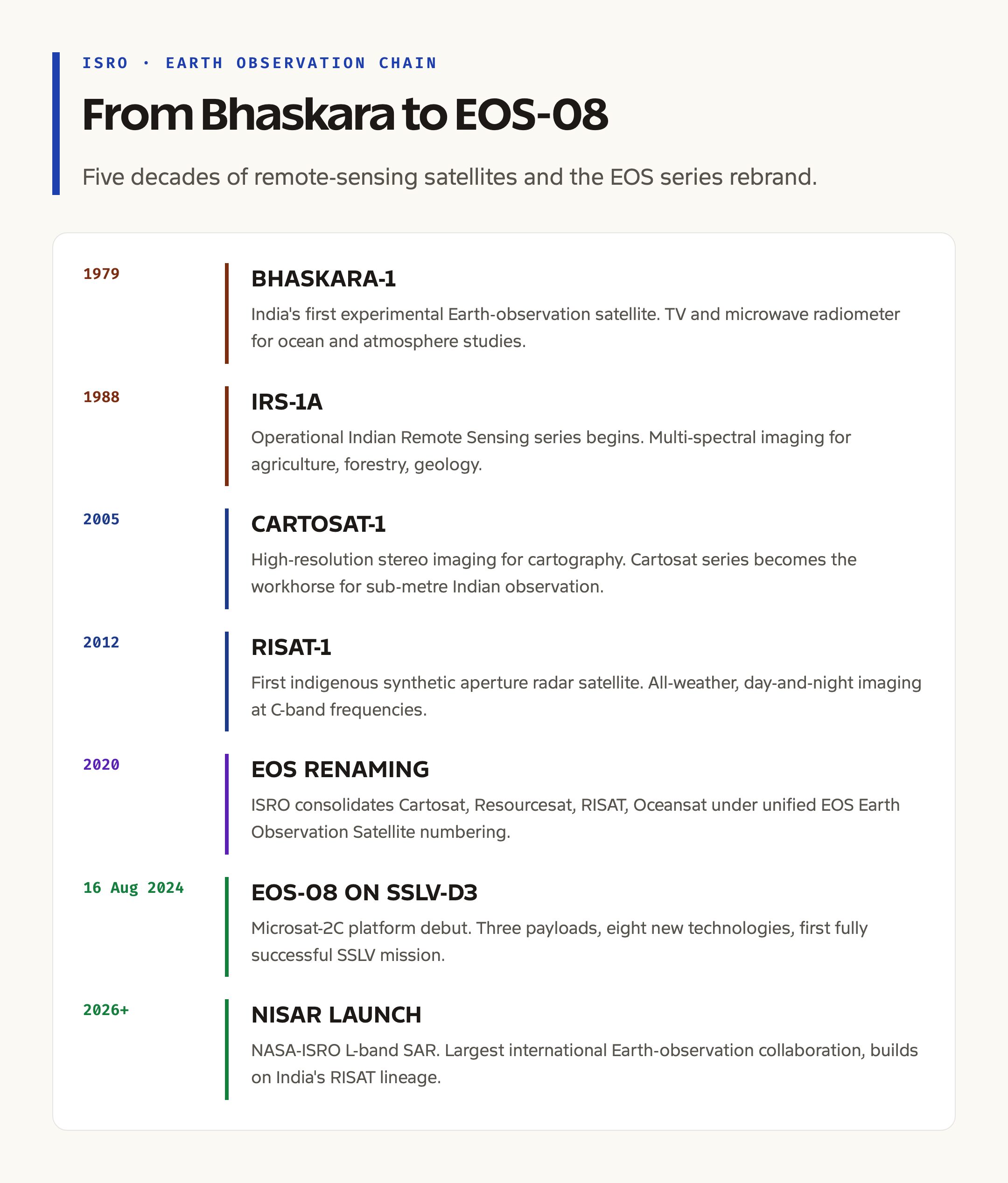
ISRO has operated Earth observation satellites since 1979 with Bhaskara-1. The current chain includes high-resolution optical satellites in the Cartosat and EOS series for cartography and surveillance, multi-spectral satellites in the Resourcesat lineage for agriculture, forest cover, and land use, oceanographic satellites in the Oceansat series for sea surface temperature and ocean colour, and radar-imaging satellites including RISAT and the upcoming NISAR mission.
EOS-08 occupies a specific niche in this chain. It is not a high-resolution optical satellite. It is a thermal-infrared and reflectometry satellite designed to complement the optical and radar fleets. The thermal capability allows night-time observation and surface-temperature mapping that optical satellites cannot match. The GNSS-R capability fills gaps in ocean wind and soil moisture coverage where dedicated radar would be too expensive.
The newer EOS naming is partly a rationalisation of the older series-specific naming and partly a rebranding signal that ISRO is moving toward a more integrated Earth observation programme. EOS-01, formerly known as RISAT-2BR2, was a synthetic aperture radar satellite. EOS-04, formerly RISAT-1A, is a C-band SAR satellite. EOS-06, formerly Oceansat-3, is an ocean colour and surface temperature mission. EOS-07 was a microsatellite tech demonstrator. EOS-08 follows that microsatellite line with a more capable payload mix.
Applications of EOS-08 Data
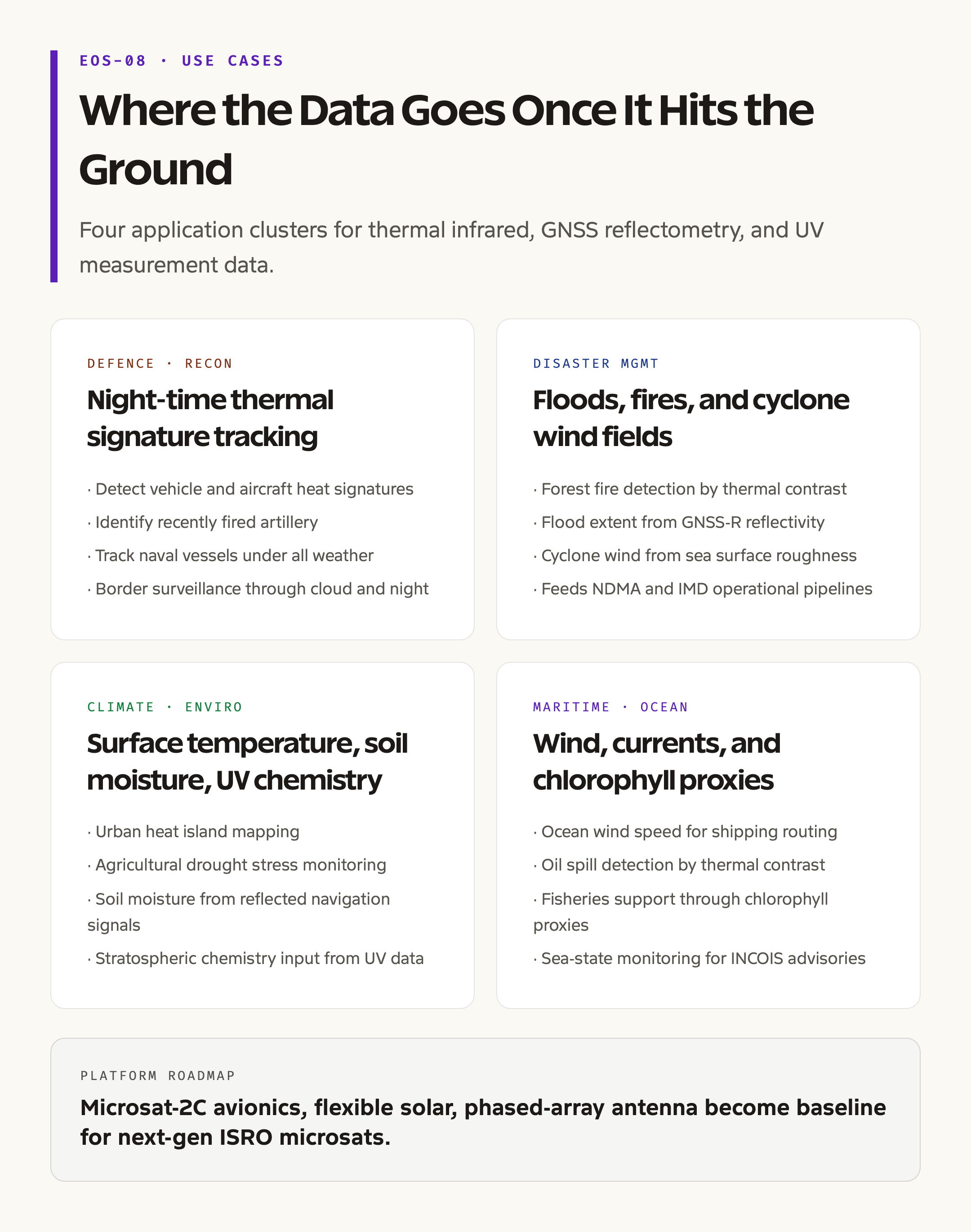
Defence and reconnaissance is the most operationally sensitive application. Long-wave infrared imaging detects vehicle and aircraft thermal signatures, identifies recently fired artillery, and tracks naval vessels under all-weather, day-and-night conditions. The 24-hour observability of thermal infrared makes it harder for adversary forces to hide activity that would be invisible to daytime optical imagery.
Disaster management benefits from both EOIR and GNSS-R data. Forest fires emit strong thermal signatures detectable by long-wave infrared, allowing early identification and tracking. Floods are mapped by GNSS-R, which detects the change in surface reflectivity when land becomes inundated. Cyclone wind fields over ocean are derived from GNSS-R-measured roughness, supporting the India Meteorological Department’s tropical cyclone tracking.
Climate and environment uses include surface temperature monitoring for urban heat islands, sea surface temperature for monsoon prediction, soil moisture for agricultural drought assessment, and UV radiation environment for stratospheric chemistry studies. The data feeds into ISRO’s Bhuvan portal and is shared through inter-agency channels with IMD, ICAR, and the National Disaster Management Authority.
Maritime applications include ocean wind monitoring for shipping route optimisation, oil spill detection through thermal contrast, and fisheries support through chlorophyll proxies derived from a combination of EOS-08 data and other satellite sources.
SSLV: The Launch Vehicle
The Small Satellite Launch Vehicle is the third leg of ISRO’s launch portfolio, alongside the workhorse PSLV and the heavier GSLV and LVM3. SSLV is a three-stage all-solid-propellant rocket with a velocity-trimming module on top, designed for rapid integration and dedicated small-satellite launches.
The SSLV target market is small commercial satellites, replacement satellites for existing constellations, and dedicated launches for scientific or experimental microsatellites that would otherwise share a PSLV ride and be constrained by the primary payload’s orbit. The vehicle is sized for payloads up to 500 kilogrammes to a 500 km low Earth orbit. Turnaround time from order to launch is targeted at well under three months, much faster than the PSLV manifest.
SSLV-D3 was the first fully successful flight in the developmental series, after the failure of D1 in 2022 and the partial success of D2 in 2023. The vehicle is now in operational service, with NewSpace India Limited, the commercial arm of ISRO, marketing dedicated SSLV launches to global customers. The SSLV success expands India’s launch portfolio at the price-competitive small-satellite end of the market.
Strategic Context for India’s Earth Observation Programme
India’s strategic case for sovereign Earth observation has three pillars. The first is defence intelligence. Foreign satellite imagery can be denied or degraded during a conflict, and commercial imagery can be priced or embargoed. India’s own constellation provides assured coverage of the borders, the Indian Ocean Region, and points of interest beyond.
The second pillar is disaster management. India sits in a high-disaster-risk zone with cyclones along both coasts, monsoon flooding across the Gangetic plain, drought in central India, and seismic and landslide risk in the Himalayas. ISRO data feeds the National Disaster Management Authority, the IMD, and state disaster response units in near-real time. EOS-08’s thermal and GNSS-R capabilities expand the available data streams.
The third pillar is climate and natural-resource governance. Forest cover monitoring under the India State of Forest Report, agricultural drought assessment under the National Agricultural Drought Assessment and Monitoring System, water-resource management under the National Hydrology Project, and air quality monitoring under the National Clean Air Programme all draw on satellite data, much of it Indian.
EOS-08 specifically extends night-time and weather-independent capability, GNSS-R surface-state data, and microsatellite platform validation for the next generation of small satellites.
What to Watch Going Forward
Three things will define the next phase of ISRO Earth observation. The first is the operationalisation of SSLV for routine microsatellite launches, which lowers the cost of building distributed Earth observation constellations. The second is the upcoming NISAR launch, a major US-Indian L-band SAR mission that will set a new bar for radar interferometry over India. The third is the increasing role of private operators in the Earth observation market under the Indian Space Policy 2023 framework, with companies like Pixxel, Galaxeye, and Satellogic India operating commercial constellations.
For UPSC, the EOS-08 mission is a useful answer-bank example of multiple ISRO objectives in one satellite, sovereign technology demonstration, defence-relevant payload, climate-monitoring instrument, and small-satellite manufacturing capability. The SSLV-D3 success is the launch-vehicle counterpart, marking the operational entry of India’s small-satellite launch tier.
Frequently Asked Questions
What does EOS-08 stand for?
EOS-08 stands for Earth Observation Satellite-08. It is the eighth satellite in ISRO’s renamed Earth observation series that replaced older series-specific names like Cartosat and Resourcesat from 2020 onward. The satellite is also called Microsat-2C in reference to the bus platform.
What is GNSS Reflectometry on EOS-08?
GNSS Reflectometry is a technique that uses reflected navigation signals from GPS, NavIC, and other constellations to measure properties of the Earth’s surface. The reflected signal carries information about ocean wind speed, soil moisture, flood extent, and ice properties. EOS-08 carries a GNSS-R receiver, not a transmitter, which makes it a low-power and low-mass instrument.
What is the difference between EOS-08 and Cartosat satellites?
Cartosat satellites are high-resolution optical imaging satellites, primarily used for cartography, urban planning, and defence reconnaissance. EOS-08 is a thermal-infrared and reflectometry satellite with moderate spatial resolution, designed for night-time observation, surface temperature mapping, and ocean wind measurement. The two complement each other rather than overlap.
What launch vehicle carried EOS-08?
EOS-08 was launched on 16 August 2024 aboard SSLV-D3, the third developmental flight of the Small Satellite Launch Vehicle. SSLV is ISRO’s smallest operational launch vehicle, designed for payloads up to 500 kilogrammes to low Earth orbit. SSLV-D3 was the first fully successful flight in the SSLV developmental series.
Why is EOS-08’s mission life only one year?
EOS-08 orbits at around 475 km altitude, lower than typical ISRO Earth observation satellites which operate at 600 to 900 km. At lower altitudes, atmospheric drag is stronger, and the satellite re-enters the atmosphere within a year or two without active propulsion. EOS-08 is designed for short-duration technology demonstration and operational validation rather than long-term mission service.