Indian Physical Geography Map — Relief, Drainage, Climate, Vegetation, Soils (UPSC Geography)
You opened a map of India and saw layers — mountains in the north, a plateau in the middle, plains in between, oceans on three sides — and the textbook explanation made it sound like five neat compartments.
You opened a map of India and saw layers — mountains in the north, a plateau in the middle, plains in between, oceans on three sides — and the textbook explanation made it sound like five neat compartments. It isn’t. The Indian physical geography map is a 3.28 million sq km puzzle where the Himalayas force the monsoon to dump rain on Cherrapunji, the Western Ghats decide what crops Kerala grows, and the Deccan plateau quietly stores 60% of India’s mineral wealth… none of which Laxmikanth or Spectrum will explain in one place. I’ve watched aspirants lose 4–6 marks in Prelims every year on physiography questions because they memorised lists without seeing the connections. This article fixes that. You’ll get relief, drainage, climate, vegetation, and soils — mapped, dated, and linked the way examiners actually ask them.
What is the Indian physical geography map?
The Indian physical geography map is the visual representation of India’s natural landscape — relief features (mountains, plateaus, plains, coasts, islands), drainage systems (Himalayan and Peninsular rivers), climatic zones (six Köppen types dominated by monsoons), natural vegetation (five major forest types), and soils (eight ICAR-classified types) — covering 3,287,263 sq km across 28 states and 8 Union Territories.
Three factual triples worth memorising:
- Area — 3,287,263 sq km — 7th largest country in the world (2026).
- Latitude — 8°4’N to 37°6’N — Tropic of Cancer (23.5°N) cuts the country into roughly equal halves.
- Coastline — 7,516.6 km — six coastal states (Gujarat, Maharashtra, Goa, Karnataka, Kerala, Tamil Nadu) plus Andhra, Odisha, West Bengal on the east.
The 5 physiographic divisions — relief mapped
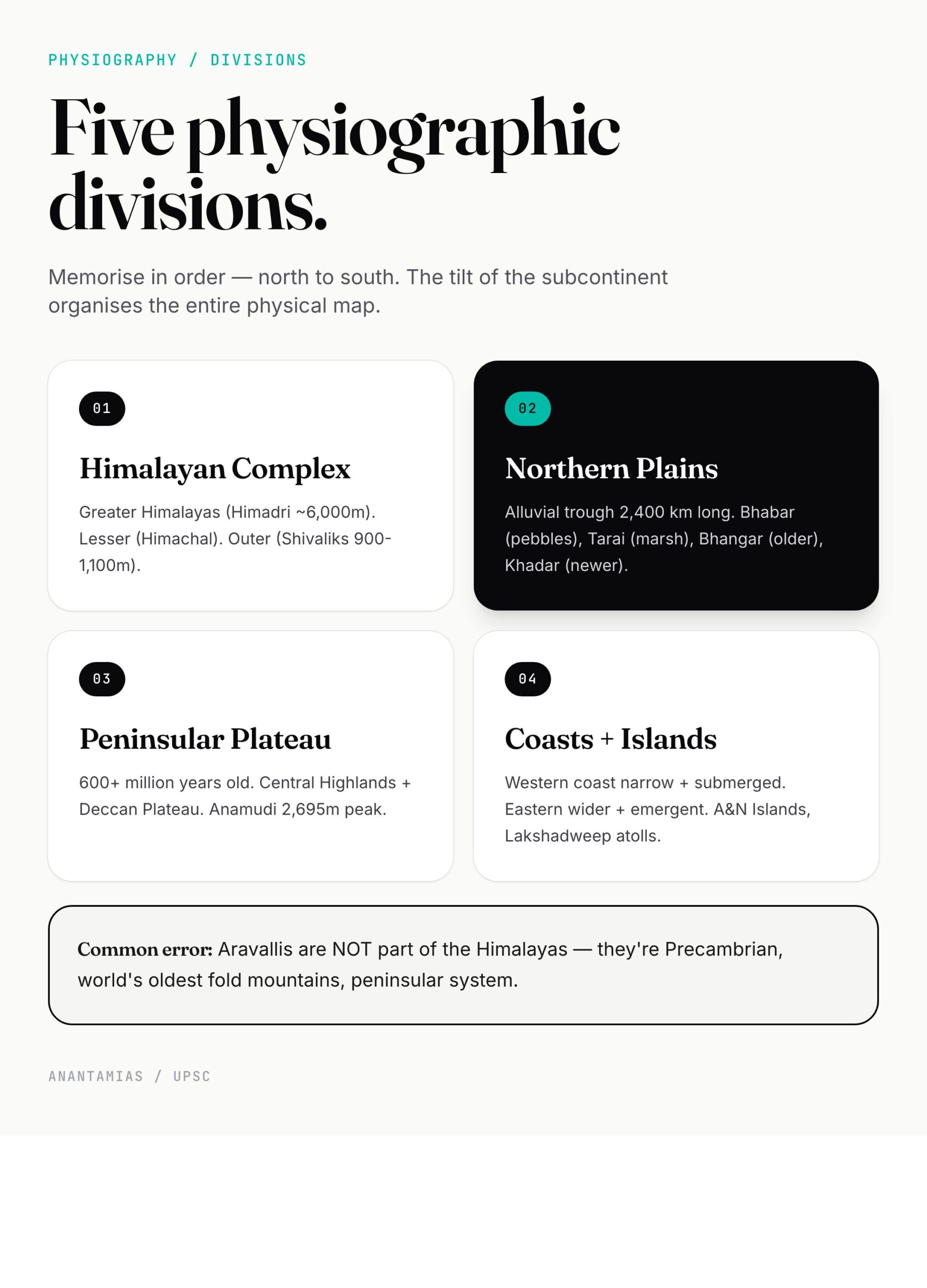
India is conventionally divided into five physiographic regions. Memorise them in this order — it follows the tilt of the subcontinent from north to south.
1. The Himalayan Mountain Complex
The youngest and tallest fold mountain system on Earth. Three parallel ranges:
- Greater Himalayas (Himadri) — average 6,000 m. Hosts Kangchenjunga (8,586 m, in Sikkim) — India’s highest peak and the world’s third-highest. Permanently snow-covered.
- Lesser Himalayas (Himachal) — 3,700–4,500 m. Pir Panjal, Dhauladhar, Mahabharat ranges. Hill stations sit here — Shimla, Mussoorie, Darjeeling.
- Outer Himalayas (Shivaliks) — 900–1,100 m. Youngest, made of unconsolidated sediments. Prone to landslides.
The Trans-Himalayas (Karakoram, Ladakh, Zanskar) lie north of the Greater Himalayas — geologically older, technically not part of the Himalayan fold proper. K2 (8,611 m) sits here in the Karakoram range, but in territory administered by Pakistan.
For a deeper look at ranges, passes and rivers, our Himalaya mountain guide breaks it down range by range. And for ecology — landslides, glacial retreat, climate change vulnerability — the Himalayas environment article is the companion read.
2. The Northern Plains
Between the Himalayas and the Peninsular Plateau lies a 2,400-km-long alluvial trough — 240 to 320 km wide — built by the Indus, Ganga, and Brahmaputra over millions of years.
Subdivisions:
- Bhabar — coarse pebbles at the foothills.
- Tarai — marshy wet zone south of Bhabar.
- Bhangar — older alluvium, slightly elevated.
- Khadar — newer alluvium, the floodplains. Most fertile.
This is India’s breadbasket — Punjab, Haryana, UP, Bihar, West Bengal. Read more in our Northern Plains of India explainer.
3. The Peninsular Plateau
The oldest landmass in India — Precambrian, over 600 million years old. Triangular, with the apex at Kanyakumari and the base along the Vindhya-Satpura line.
Two main divisions:
- Central Highlands — Aravalli, Vindhya, Satpura, Malwa, Chota Nagpur, Bundelkhand.
- Deccan Plateau — south of the Narmada-Tapi line. Bordered by Western Ghats (Sahyadri, average 1,200 m, highest peak Anamudi 2,695 m) and Eastern Ghats (broken, average 600 m).
The plateau holds nearly all of India’s metallic minerals — coal, iron ore, bauxite, manganese. Our peninsular plateau deep-dive covers the geology and resources.
4. The Coastal Plains
- Western Coastal Plain — narrow (50–100 km), submerged coast. Konkan (north), Kanara (middle), Malabar (south). Lagoons and backwaters.
- Eastern Coastal Plain — wider (100–200 km), emergent coast. Northern Circars (north) and Coromandel (south). Major deltas — Mahanadi, Godavari, Krishna, Cauvery.
5. The Islands
- Andaman and Nicobar Islands (Bay of Bengal) — 572 islands, volcanic and coral origin. Barren Island is India’s only active volcano.
- Lakshadweep Islands (Arabian Sea) — 36 coral atolls. Smallest UT by area.
For more, see islands of India.
Drainage system — Himalayan vs Peninsular rivers
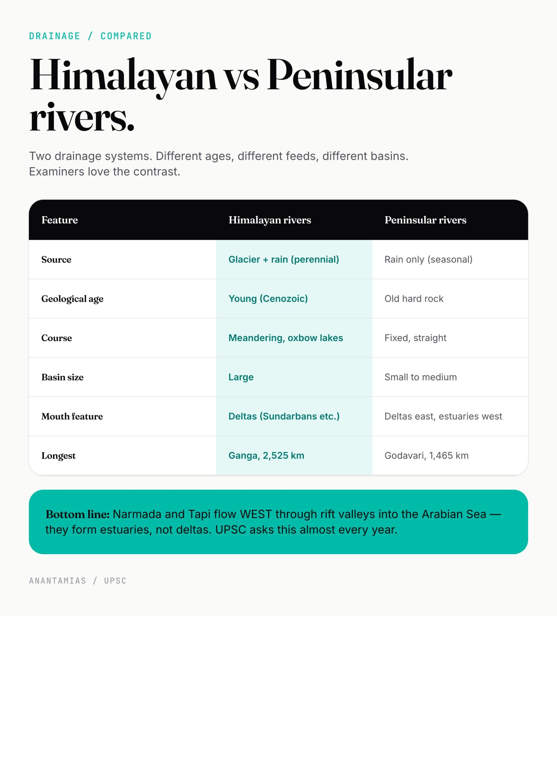
This is the single highest-yield section in physical geography. Examiners love comparison questions here.
Himalayan rivers (Indus, Ganga, Brahmaputra systems)
Perennial. Snow-fed plus rain-fed. Form large meandering courses, oxbow lakes, fertile floodplains. Three systems:
- Indus system — Indus, Jhelum, Chenab, Ravi, Beas, Sutlej. The Indus Waters Treaty (1960) gave India full rights over the eastern rivers (Ravi, Beas, Sutlej) and limited rights over the western three. See Indus Waters Treaty 1960.
- Ganga system — origin Gangotri Glacier (Uttarakhand), 2,525 km long, India’s longest river. Major tributaries: Yamuna, Ghaghara, Gandak, Kosi, Son. Read Ganga river system.
- Brahmaputra system — originates in Tibet (Yarlung Tsangpo), enters Arunachal as Siang, becomes Brahmaputra in Assam. Read Brahmaputra river system.
Peninsular rivers (East-flowing and West-flowing)
Mostly seasonal, rain-fed, fixed courses, smaller basins. Two groups:
- East-flowing into Bay of Bengal — Mahanadi, Godavari (1,465 km — second-longest in India after Ganga), Krishna, Cauvery. Form deltas. Read Godavari river and Krishna river.
- West-flowing into Arabian Sea — Narmada (1,312 km) and Tapi flow through rift valleys (no deltas, only estuaries). Plus shorter rivers like Mandovi, Sharavati, Periyar.
Our river systems of India article maps every major river with origin and tributaries. For ranking, see longest river in India.
Drainage patterns deserve their own chapter — dendritic, trellis, radial, rectangular. Each pattern hints at underlying geology. Read drainage patterns for the full classification.
Climate — six Köppen zones, one monsoon
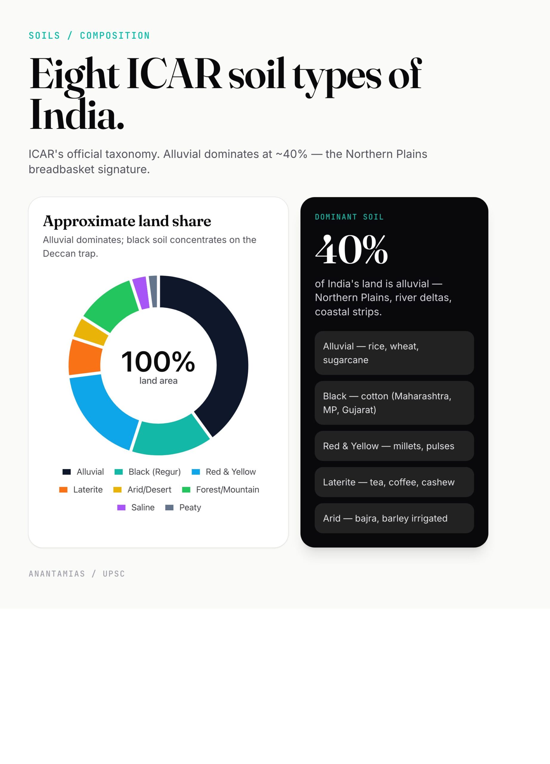
India’s climate is monsoonal — that one word does most of the work. But the Köppen-Geiger classification recognises six distinct climate zones across the country:
- Aw — Tropical wet and dry (savanna) — most of peninsular India.
- Am — Tropical monsoon — Kerala, coastal Karnataka, Goa, parts of NE India.
- As — Tropical wet (dry summer) — narrow east coast strip, Coromandel.
- BWh / BSh — Hot desert and semi-arid — Rajasthan, parts of Gujarat, Haryana, Punjab.
- Cwa / Cwb — Humid subtropical — Indo-Gangetic plain, north India.
- E — Mountain / Tundra — high Himalayas, Ladakh.
The four seasons recognised by IMD:
- Cold weather (Dec–Feb)
- Hot weather (Mar–May)
- Southwest monsoon (Jun–Sep) — 75% of annual rainfall.
- Retreating monsoon (Oct–Nov) — Tamil Nadu gets most of its rain in this season from the NE monsoon.
Mawsynram (Meghalaya) holds the global record for highest average annual rainfall — 11,872 mm. Cherrapunji is a few km away. The Thar desert at the other extreme gets under 200 mm… and yet they sit in the same country. Honestly, this contrast is what makes Indian climate the Mains question that keeps coming back.
For mechanism, mapping, and impact, our monsoon in India is the deep dive. The Köppen climate classification breaks down each zone with examples. And seasons in India covers the IMD four-season model.
Natural vegetation — 5 forest types
Vegetation in India follows rainfall, temperature, and altitude. The five major forest types per the Champion-Seth classification (the basis for ICFRE’s official taxonomy):
- Tropical Evergreen Forests — rainfall >200 cm. Western Ghats, Andaman, NE India. Rosewood, mahogany, ebony.
- Tropical Deciduous (Monsoon) Forests — rainfall 70–200 cm. Largest forest type in India. Sub-divided into Moist Deciduous (sal, teak) and Dry Deciduous (axlewood, palas).
- Tropical Thorn Forests and Scrubs — rainfall <70 cm. Rajasthan, Gujarat, parts of MP. Acacia, babool, kikar.
- Montane Forests — Himalayas. Subdivided altitudinally — wet temperate, dry temperate, alpine. Oak, fir, pine, deodar.
- Mangrove (Tidal) Forests — coasts, deltas. Sundarbans (largest), Bhitarkanika, Pichavaram. Sundari is the dominant species.
The full breakdown with state-wise distribution lives in our natural vegetation of India article. Coniferous belts in the Himalayas are covered in coniferous forest, and mangroves get a dedicated treatment in mangroves and MISHTI Scheme.
Soils — 8 ICAR types
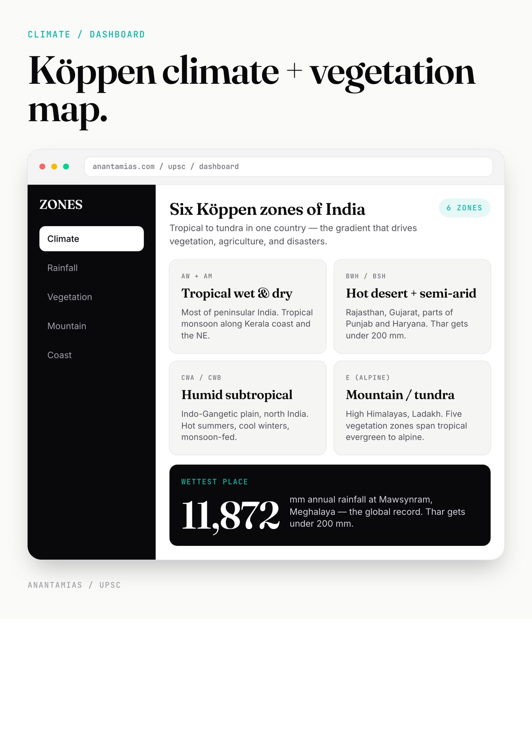
The Indian Council of Agricultural Research (ICAR) recognises eight major soil types. Memorise them with their distribution and dominant crop — that’s how UPSC asks them.
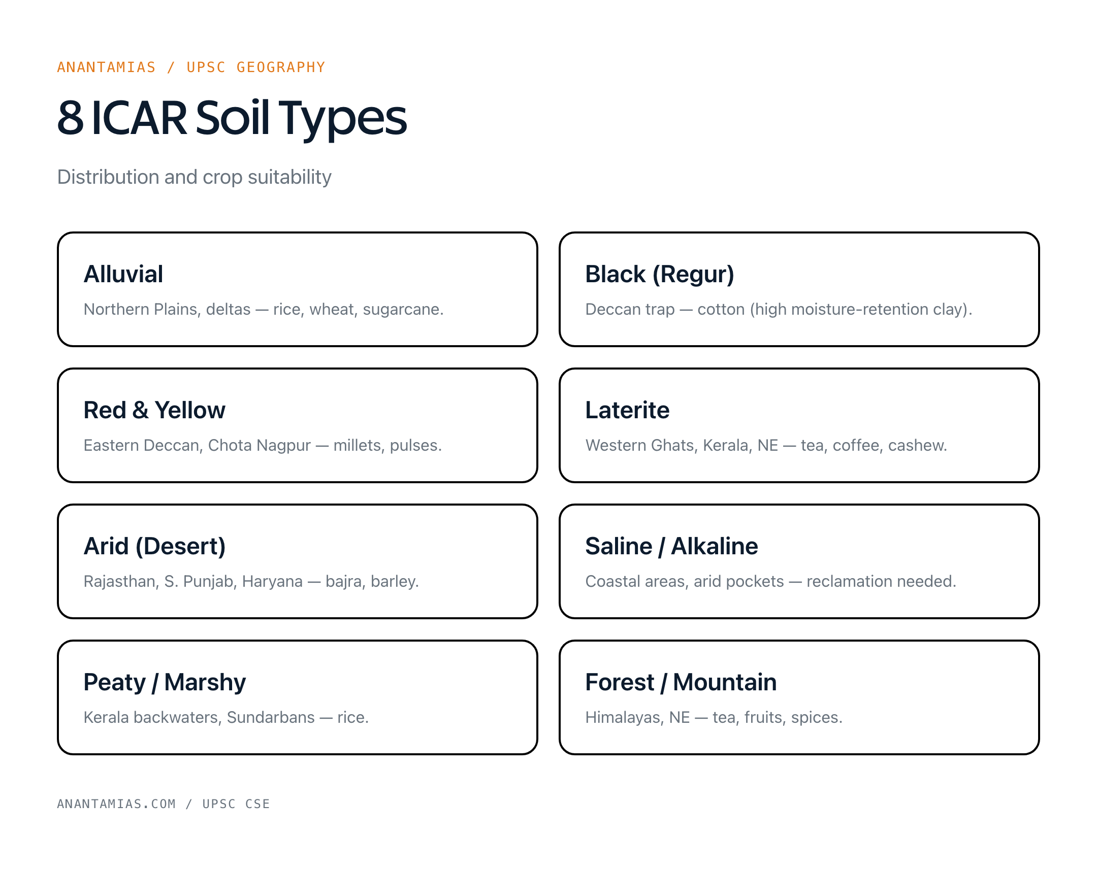
| # | Soil Type | Where | Best Crops |
|---|---|---|---|
| 1 | Alluvial | Northern Plains, river deltas | Rice, wheat, sugarcane |
| 2 | Black (Regur) | Deccan trap — Maharashtra, MP, Gujarat | Cotton (“black cotton soil”) |
| 3 | Red and Yellow | Eastern Deccan, Chota Nagpur | Millets, pulses |
| 4 | Laterite | Western Ghats, NE India, Kerala | Tea, coffee, cashew |
| 5 | Arid (Desert) | Rajasthan, S. Punjab, Haryana | Bajra, barley (irrigated) |
| 6 | Saline / Alkaline | Coastal areas, arid regions | Limited; reclamation needed |
| 7 | Peaty / Marshy | Kerala backwaters, Sunderbans | Rice |
| 8 | Forest / Mountain | Himalayas, NE | Tea, fruits, spices |
Black soil’s high moisture-retention capacity comes from its montmorillonite clay content. Laterite forms by intense leaching in hot-wet climates. Alluvial soils are richest because they’re constantly renewed by river deposition.
For the full classification and SLUSI mapping, see soil types of India.
Why the physical geography map matters for UPSC
Let me be specific about where this shows up.
Prelims — every year. 2024 had a question on the southwestern monsoon’s mechanism. 2023 asked about black soil distribution. 2022: Cauvery basin states. The pattern? Map-based MCQs anchored to one feature.
Mains GS-I — paper 1, the geography section. Questions like “Discuss the impact of the Western Ghats on monsoon distribution” (2018) or “Examine the changing pattern of natural vegetation in the Himalayan region” (2021).
Essay — geography rarely shows up directly, but climate change + vegetation + soils all feed environment essays.
Interview — if you’re from a state with distinctive geography (Kerala laterite, Rajasthan desert, NE forest types), expect questions.
Look — most coaching notes treat physical geography as memorisation. It isn’t. It’s a system. The Himalayas trap the monsoon, which drops alluvium in the Northern Plains, which feeds the Ganga, which carves out the Sundarbans, where mangroves protect the coast from cyclones… see what I mean? Connected.
Common misconceptions
- “K2 is India’s highest peak” — Wrong. K2 (8,611 m) is in Pakistan-administered territory. India’s highest is Kangchenjunga (8,586 m) in Sikkim. K2 is taller but not in India.
- “Aravallis are part of the Himalayas” — No. Aravallis are among the world’s oldest fold mountains (Precambrian), part of the Peninsular Plateau system. Himalayas are the youngest (Cenozoic).
- “Narmada and Tapi flow east” — They flow west through rift valleys into the Arabian Sea. The “east-flowing rivers form deltas” rule applies to Mahanadi, Godavari, Krishna, Cauvery.
- “Black soil is fertile because of organic matter” — Wrong. Black soil’s fertility comes from its mineral content (calcium carbonate, magnesium, potash, lime) and water-retention. Organic matter is actually low.
How to revise this in 30 minutes
Source priority:

Oxford Student Atlas for India — 7th Edition
- 160 pages, Oxford University Press, the current edition
- India-focused thematic maps: physical, political, rivers, climate, soils, vegetation, plus world maps
- Made for UPSC and state PSC map work; slim enough to stay open beside the textbook
- NCERT Class 11 — *India: Physical Environment* (chapters 1–6). Non-negotiable.
- GC Leong — *Certificate Physical and Human Geography* (the “world geography” base).
- Mahesh Barnwal — *Indian Geography* (compact UPSC-aligned).
- PMF IAS Geography Notes (online, free, well-mapped).
- Atlas — Orient Blackswan or Oxford School Atlas of India (turn pages while reading).
Revision order: relief → drainage → climate → vegetation → soils. Each in 5–6 minutes with the atlas open. Then test yourself on a blank India outline map.
Frequently Asked Questions
Watch on YouTube
Related video from the Anantam IAS YouTube channel.
What are the five physiographic divisions of India?
Himalayas, Northern Plains, Peninsular Plateau, Coastal Plains, and Islands. Each has subdivisions and distinctive geology.
Which is India’s longest river?
The Ganga — 2,525 km from Gangotri to Bay of Bengal. The Godavari is the longest peninsular river at 1,465 km.
What is the difference between Himalayan and Peninsular rivers?
Himalayan rivers are perennial (snow + rain fed), form large basins with meandering courses, and have young geology. Peninsular rivers are seasonal (rain-fed only), have fixed courses through old hard rock, and form deltas (east-flowing) or estuaries (west-flowing).
How many Köppen climate zones does India have?
Six — tropical wet and dry, tropical monsoon, hot desert/semi-arid, humid subtropical, mountain, and tropical wet (with dry summer).
What is the most common soil type in India?
Alluvial soil — covers ~40% of India’s land area, mostly in the Northern Plains and river deltas. It’s also the most agriculturally productive.
Which is India’s highest peak?
Kangchenjunga in Sikkim, at 8,586 m — third-highest in the world.
How many Ramsar sites does India have in 2026?
99 Ramsar sites as of April 2026, covering 13.6 lakh hectares across 28 states and UTs. Tamil Nadu has the most (20).
What is the difference between Western and Eastern Ghats?
Western Ghats are continuous, average 1,200 m, run 1,600 km, and trap the southwest monsoon. Eastern Ghats are broken into ranges, average 600 m, and crossed by major east-flowing rivers.