Indus Valley Civilization: Features & Important Sites
Complete UPSC guide to the Indus Valley Civilization — Harappa, Mohenjo-daro, Lothal, Dholavira, Kalibangan, town planning, drainage system, Great Bath, seals, trade, and decline theories.
Indus Valley Civilization: Features & Important Sites
The Indus Valley Civilization is the oldest and largest of the world’s four ancient urban civilisations — the others being Mesopotamia, Egypt, and China. At its peak (c. 2600–1900 BCE), it covered roughly 1.25 million square kilometres — larger than the combined area of ancient Egypt and Mesopotamia — and may have had a population of 5 million.
And yet it remains in many ways the most mysterious. We cannot read its script. We don’t know what its people called themselves. We don’t know how its cities were governed, why there are no obvious palaces or temples, and we don’t fully understand why it declined.
What we do know is remarkable enough. The cities were planned with a sophistication not seen elsewhere in the ancient world. The drainage system was the world’s most advanced until Roman times. Trade connections reached Mesopotamia. Standardised weights and measures operated across a thousand miles.
For UPSC, the Indus Valley Civilization is essential Ancient History. Know the major sites, the urban features, the material culture, and the decline theories.
Discovery and Excavation
The civilisation was entirely unknown to modern scholarship until 1921, when Daya Ram Sahni excavated Harappa (in present-day Pakistan’s Punjab province). R.D. Banerji excavated Mohenjo-daro (in Sindh, Pakistan) the same year. The Archaeological Survey of India, under John Marshall, announced the discovery to the world in 1924.
The name “Indus Valley Civilization” reflects the early association with the Indus River valley. But as excavations expanded — particularly after 1947, when India and Pakistan divided the original discovery sites — it became clear the civilisation extended far beyond the Indus valley, into Rajasthan, Gujarat, Haryana, and even Uttar Pradesh and Maharashtra. “Harappan Civilization“ (after its first discovered site) is now preferred by many archaeologists.
The civilisation is conventionally dated c. 3300–1300 BCE in its full span, with the mature urban phase c. 2600–1900 BCE.
Major Sites
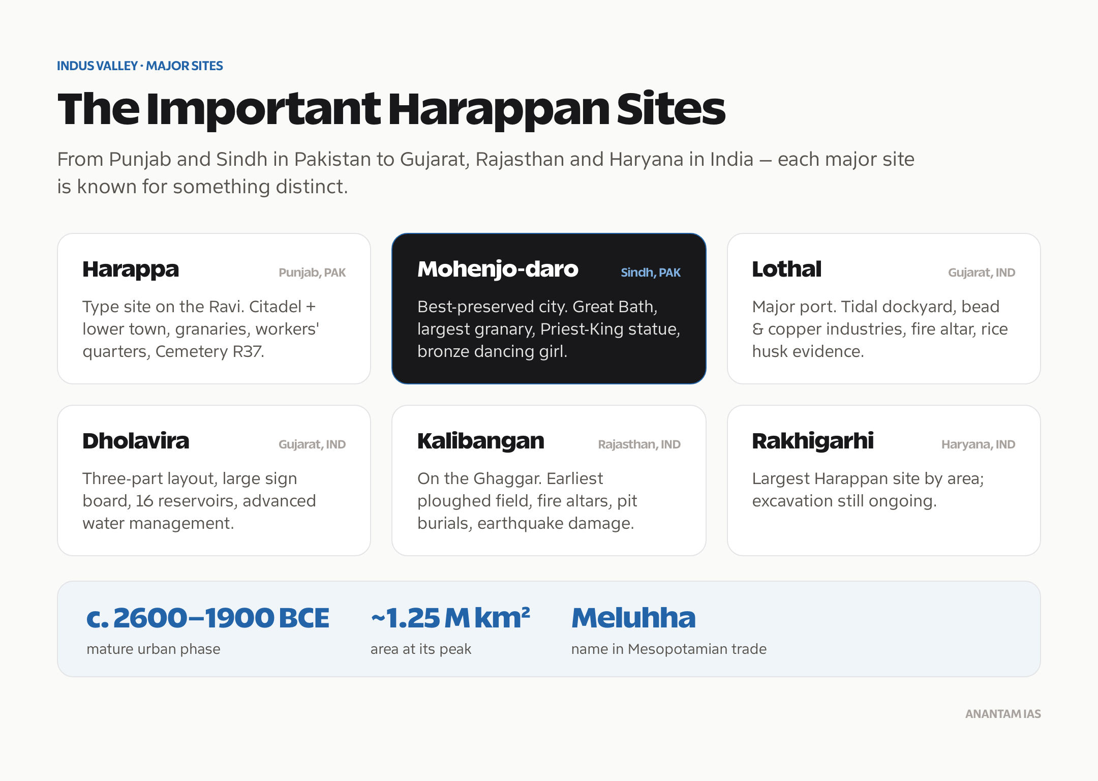
Harappa (Pakistan, Punjab)
Harappa is the type site — the city after which the civilisation is named. Located on the old course of the Ravi River, it was excavated repeatedly from 1921 onwards, unfortunately with significant damage from 19th-century railway construction (the Lahore-Multan railway used Harappa bricks as ballast).
Key features found at Harappa:
- Evidence of a citadel mound and a lower town — the typical two-part layout of Harappan cities
- Granaries — large storage structures north of the citadel
- Workers’ quarters — rows of small identical houses suggesting organised labour or industrial production
- Two-piece bronze dancing girl figurine (actually found at Mohenjo-daro — this is a common confusion in UPSC)
- Cemetery R37 — providing skeletal remains for physical anthropology studies
Mohenjo-daro (Pakistan, Sindh)
Mohenjo-daro (“Mound of the Dead” in Sindhi) is the best-preserved and most extensively studied Harappan city. Located on the west bank of the Indus River, it was rebuilt at least seven times on the same spot — each time raising the level of the city.
Key features:
- The Great Bath — the most famous structure of the civilisation
- Granary — the largest known Harappan structure, with a highly ventilated base
- Assembly Hall — a large pillared building possibly used for public gatherings
- Streets laid in a grid pattern, with main streets running north-south and east-west
- Elaborate drainage system
- Priest-King statue — a soapstone figure wearing a trefoil-decorated robe, one of the most recognised artefacts of the civilisation
- Bronze dancing girl figurine — a naturalistic female figure showing advanced bronze-casting technique
Lothal (India, Gujarat)
Lothal is the most important Harappan site in India. Excavated by S.R. Rao from 1955 onwards, it is located near the Gulf of Khambhat (Cambay) in Gujarat.
Lothal is significant for:
- Dockyard — a large brick-lined basin (218m × 37m) interpreted as the world’s earliest tidal dockyard, though some archaeologists debate this interpretation
- Evidence of bead manufacturing and copper-smelting industries
- A unique structure interpreted as a fire altar, suggesting links to Vedic ritual
- Metalwork, ivory, and shell objects suggesting active artisanal production
- Cemetery with evidence of double burials (male and female together)
- Rice husk evidence suggesting rice cultivation
Lothal’s location suggests it was a major Harappan trading port for maritime commerce with the Persian Gulf and Mesopotamia.
Dholavira (India, Gujarat)
Dholavira is located on Khadir island in the Rann of Kutch, Gujarat. Excavated by R.S. Bisht from 1990 onwards, it is one of the five largest Harappan cities and the largest in India.
Unique features of Dholavira:
- Three-part layout (citadel, middle town, lower town) — unlike the standard two-part Harappan layout
- Large inscribed sign board — the largest known Harappan inscription, with 10 signs; displayed publicly, suggesting a civic or commercial announcement
- Stadium or ceremonial ground — a large open area between the citadel and middle town
- Sophisticated water management — Dholavira is located in an arid zone and developed an extraordinary system of reservoirs, dams, and channels to collect and store rainwater and stream water
- 16 reservoirs of varying sizes
- Stepped wells and water channels connecting reservoirs
Dholavira was inscribed as a UNESCO World Heritage Site in 2021 — India’s 40th.
Kalibangan (India, Rajasthan)
Kalibangan (“Black Bangles”) is located on the dried-up Ghaggar River (possibly the ancient Sarasvati) in Rajasthan. Excavated by B.B. Lal and B.K. Thapar in the 1960s.
Key findings:
- Pre-Harappan ploughed field — the earliest evidence of ploughing in the subcontinent
- Fire altars in a regular arrangement, suggesting organised ritual activity
- A unique pit burial tradition distinct from other Harappan sites
- Evidence of earthquake damage — one of the early sites to show earthquake disruption
- Both a citadel and lower town
Other Important Sites
| Site | Location | Key Feature |
|---|---|---|
| Rakhigarhi | Haryana | Largest Harappan site by area; still being excavated |
| Banawali | Haryana | Pre-Harappan and Harappan layers; barley cultivation evidence |
| Surkotada | Gujarat | Horse bones (controversial); fortifications |
| Chanhudaro | Sindh (Pakistan) | No citadel; jewellery and bead workshop |
| Kot Diji | Sindh (Pakistan) | Important pre-Harappan/Early Harappan site |
| Mehrgarh | Balochistan (Pakistan) | Pre-Harappan agricultural settlement; 7000 BCE |
Town Planning: The Defining Feature
The most remarkable characteristic of Harappan cities is their systematic town planning — evidence of a governing authority capable of standardised urban design across hundreds of miles.
Grid Layout
Harappan cities were laid out on a grid. Main streets ran roughly north-south and east-west, with lanes intersecting at right angles. Streets were wide enough for cart traffic. The main roads at Mohenjo-daro were up to 10 metres wide.
Two-Part Division
Most major cities show a characteristic division:
- Citadel (upper town): On an artificially raised mud-brick platform. Contained large public buildings — granaries, great baths, assembly halls. More carefully planned and defended.
- Lower town: Where most of the population lived. Laid out in the grid pattern.
This separation suggests social stratification — an administrative or priestly class in the citadel, with the general population below.
Standardised Construction
Harappan bricks were standardised — in a ratio of approximately 1:2:4 (height:width:length). This ratio held across sites from Punjab to Gujarat, separated by 1,500 kilometres. Standardised weights — made of chert (a hard stone) — followed a binary system (1, 2, 4, 8, 16, 32…) and a decimal system at larger weights. This standardisation across such a large area implies a degree of administrative or commercial coordination that is still not fully understood.
The Drainage System
The Harappan drainage system was the most sophisticated in the ancient world before Rome.
Features:
- Every house had its own bathroom (with a drain) and often a well
- Drains from individual houses connected to street drains
- Street drains were covered with brick slabs (which could be lifted for cleaning)
- Drains ran in channels beneath the streets, sloping toward larger outfall drains
- Inspection holes at intervals allowed maintenance
This implies municipal sanitation — an authority that planned and maintained the drainage infrastructure across the city. It also implies a concern for public health and cleanliness that is culturally significant.
The Great Bath at Mohenjo-daro
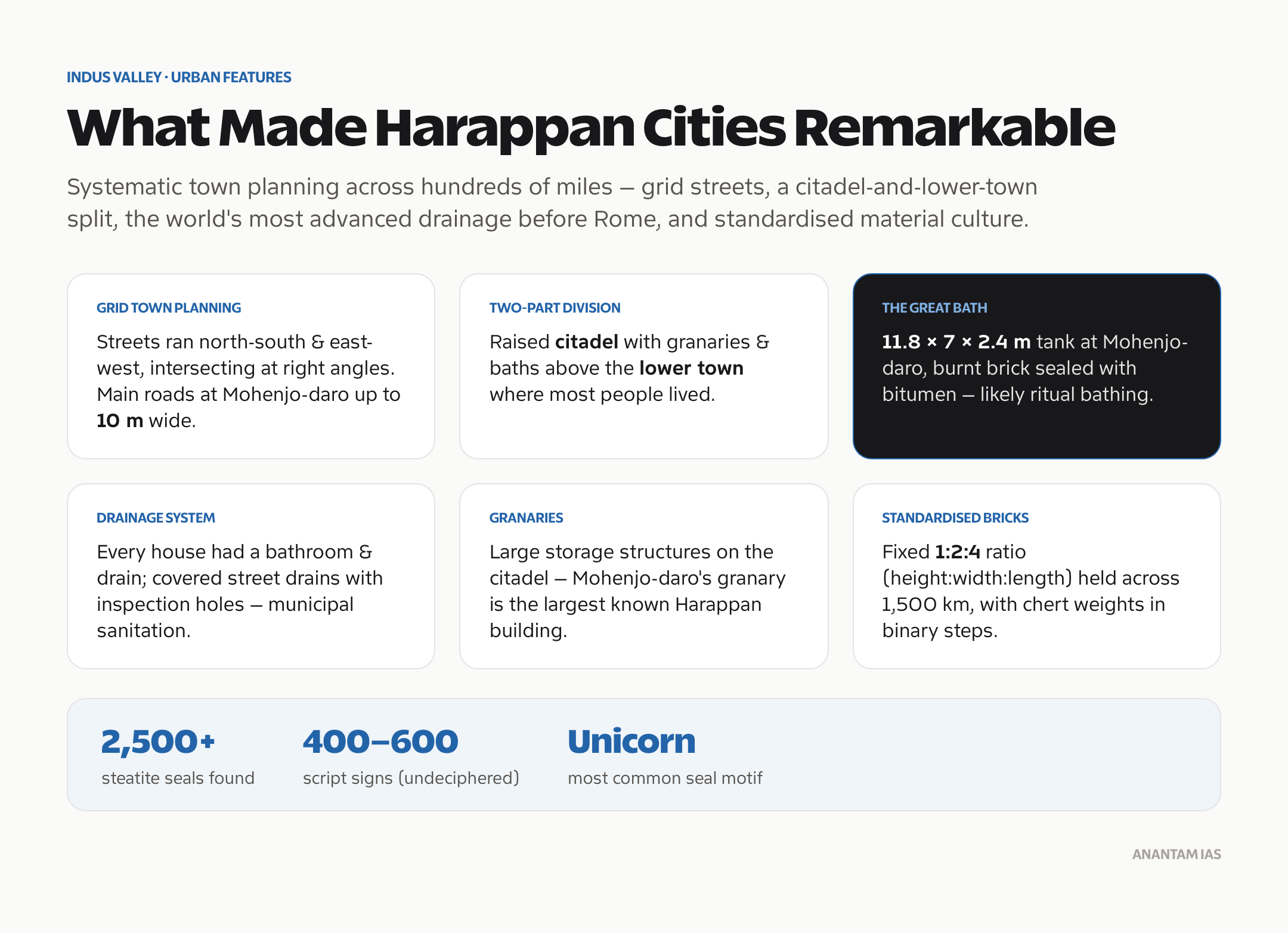
The Great Bath is 11.8m × 7m × 2.4m deep, lined with fine burnt brick with a bitumen seal to prevent leakage. Steps lead down from the north and south ends. Small rooms surround the bath on three sides.
It is one of the most discussed structures in ancient history. Interpretations:
- A ritual bathing tank for purification ceremonies (Marshall’s original interpretation, still widely accepted)
- A public bath for the urban population
- A storage tank or reservoir
The care with which it was waterproofed (bitumen is a significant undertaking) suggests it was not merely functional but had symbolic or ritual importance.
Seals and the Undeciphered Script
Over 2,500 seals have been found at Harappan sites. They are typically small (2–5 cm square), made of steatite (soapstone), and show animals with inscriptions above them.
Common animals on seals: Unicorn (the most common), zebu bull, elephant, rhinoceros, tiger, water buffalo. The “unicorn” is probably a bull in profile — the single horn appears to be a convention of showing a two-horned animal from the side.
The Harappan script: The seals bear short inscriptions — typically 5–10 signs. The script has roughly 400–600 distinct signs — too many for an alphabet (which typically has 20–40 signs) but possibly consistent with a logo-syllabic script (like Sumerian cuneiform or Egyptian hieroglyphs). Despite dozens of serious decipherment attempts, it remains undeciphered — one of the great puzzles of linguistics.
The lack of a bilingual inscription (like the Rosetta Stone for Egyptian) makes the task extremely difficult. Without knowing what language underlies the script, decipherment is largely guesswork.
Trade and Economy
Harappan society was highly commercial. Evidence of trade connections includes:
- Mesopotamian records refer to a land called Meluhha that traded lapis lazuli, carnelian, ivory, and timber — many scholars identify Meluhha with the Harappan civilisation
- Harappan artefacts (seals, weights, carnelian beads) found in Mesopotamian sites (Ur, Kish, Lagash)
- Mesopotamian artefacts found in Harappan sites
- The Lothal dockyard (if accurately identified) as a centre of maritime trade
- Cotton textiles — Harappans may have been the world’s earliest cotton growers; cotton impressions have been found
- Standardised weights used for commercial measurement
The economy was agricultural (wheat, barley, rice, peas, sesame, cotton) and commercial. There is no evidence of large-scale warfare or of a warrior class — no weapons of war, no images of battles.
Religion and Ritual
No Harappan temple has been definitively identified. But evidence for religious practice includes:
- “Priest-King” statue — a figure in a posture sometimes compared to yogic meditation; the trefoil decoration on the robe may be symbolic
- Pashupati Seal — a figure sitting cross-legged surrounded by animals, interpreted as a proto-Shiva figure (Pashupati, lord of animals)
- Female figurines — hundreds of terracotta female figurines, possibly goddess figures
- Fire altars at Kalibangan and Lothal
- Sacred trees depicted on seals (pipal/fig tree, which remains sacred in Hinduism)
- Animals apparently depicted as sacred or symbolically important on seals
These elements have led some scholars to see connections between Harappan religion and later Hinduism. The debate is ongoing.
Decline: The Major Theories
The Harappan civilisation declined between approximately 1900 and 1300 BCE — a gradual process, not a single event. Multiple theories have been proposed.
1. Aryan Invasion Theory (largely discredited): R.B. Wheeler proposed that an “Aryan” migration/invasion destroyed the civilisation. This is now largely rejected by mainstream archaeology — there is no evidence of military conquest.
2. Climate change and drought: The most widely accepted current theory. Paleoclimatic evidence suggests a prolonged drought (the “4.2 kiloyear event“) around 2200–1900 BCE, possibly connected to the monsoon weakening. The Ghaggar-Hakra River (possibly ancient Sarasvati) appears to have dried up around this time, which would have been catastrophic for settlements along it.
3. River course changes: Seismic activity may have shifted the courses of rivers, cutting off water supplies to cities.
4. Flooding: Mohenjo-daro shows signs of repeated flooding, which may have made the city uninhabitable.
5. Trade collapse: If Mesopotamian trade (linked to the Akkadian Empire’s collapse around 2150 BCE) declined, Harappan commercial cities would have lost their economic basis.
Most historians favour a combination of climate change, river course changes, and consequent agricultural and economic stress.
Frequently Asked Questions
Who discovered the Indus Valley Civilization?
The civilisation was discovered in 1921 when Daya Ram Sahni excavated Harappa and R.D. Banerji excavated Mohenjo-daro, both under the Archaeological Survey of India. John Marshall announced the discovery to the world in 1924 in the Illustrated London News.
What is the significance of the Great Bath at Mohenjo-daro?
The Great Bath (11.8m × 7m × 2.4m deep) at Mohenjo-daro is the most famous structure of the Harappan civilisation. It was carefully waterproofed with bitumen and surrounded by changing rooms. It is generally interpreted as a ritual bathing tank used for purification ceremonies, and it suggests an organised religious or civic life. It is one of the world’s oldest public water structures.
Why is the Harappan script important and why can’t we read it?
The Harappan script is important because it appears on thousands of seals and artefacts — but it remains undeciphered, meaning we cannot directly access Harappan language, beliefs, governance, or history from written records. It has roughly 400–600 distinct signs (suggesting a logo-syllabic system) but no bilingual inscription has been found to use as a key. Dozens of decipherment claims have been made; none is accepted by mainstream scholars.
What was special about Harappan town planning?
Harappan cities were laid out on a grid of streets running north-south and east-west. They had a two-part structure (elevated citadel + lower town), standardised brick dimensions (1:2:4 ratio) used consistently across sites 1,500 km apart, covered drainage systems running beneath streets, and individual houses with bathrooms and wells. This level of urban planning was unmatched in the ancient world at the time.
What caused the decline of the Indus Valley Civilization?
The most widely accepted theory is climate change — specifically a prolonged drought (the 4.2 kiloyear event, c. 2200–1900 BCE) combined with changes in river courses, particularly the drying of the Ghaggar-Hakra river. Trade collapse with Mesopotamia and repeated flooding at some sites may have contributed. The decline was gradual — population dispersed and smaller post-Harappan settlements continued — rather than a sudden end.