Disclosure: this guide contains Amazon affiliate links. As an Amazon Associate, Anantam IAS earns from qualifying purchases — at no extra cost to you.
The Indus River (known as Sindhu in Sanskrit) is one of the longest rivers in Asia and the most important river of the western subcontinent. It gave India its name, cradled the Indus Valley Civilization — one of the world’s earliest urban cultures — and remains central to the geopolitics of South Asia through the Indus Water Treaty. For UPSC aspirants, the Indus system is essential across Geography, History, and International Relations papers.
Origin and Course
The Indus originates near Lake Mansarovar in the Tibetan Plateau, at an elevation of approximately 5,500 metres near the Bokhar Chu glacier close to the Kailash range. In Tibet, it is known as Sengge Zangbo (Lion River).

Oxford Student Atlas for India — 7th Edition
- 160 pages, Oxford University Press, the current edition
- India-focused thematic maps: physical, political, rivers, climate, soils, vegetation, plus world maps
- Made for UPSC and state PSC map work; slim enough to stay open beside the textbook
Course Through Tibet and India
From its source, the Indus flows northwest through Tibet for about 320 km before entering India through the Ladakh region of Jammu and Kashmir. In Ladakh, it flows between the Ladakh Range and the Zanskar Range, passing through Leh. The Zanskar River joins the Indus near Leh.
The river then cuts through the Baltistan region (Pakistan-administered Kashmir), makes a dramatic bend near Nanga Parbat (one of the world's deepest gorges), and enters the plains of Pakistan near Attock.
Course Through Pakistan
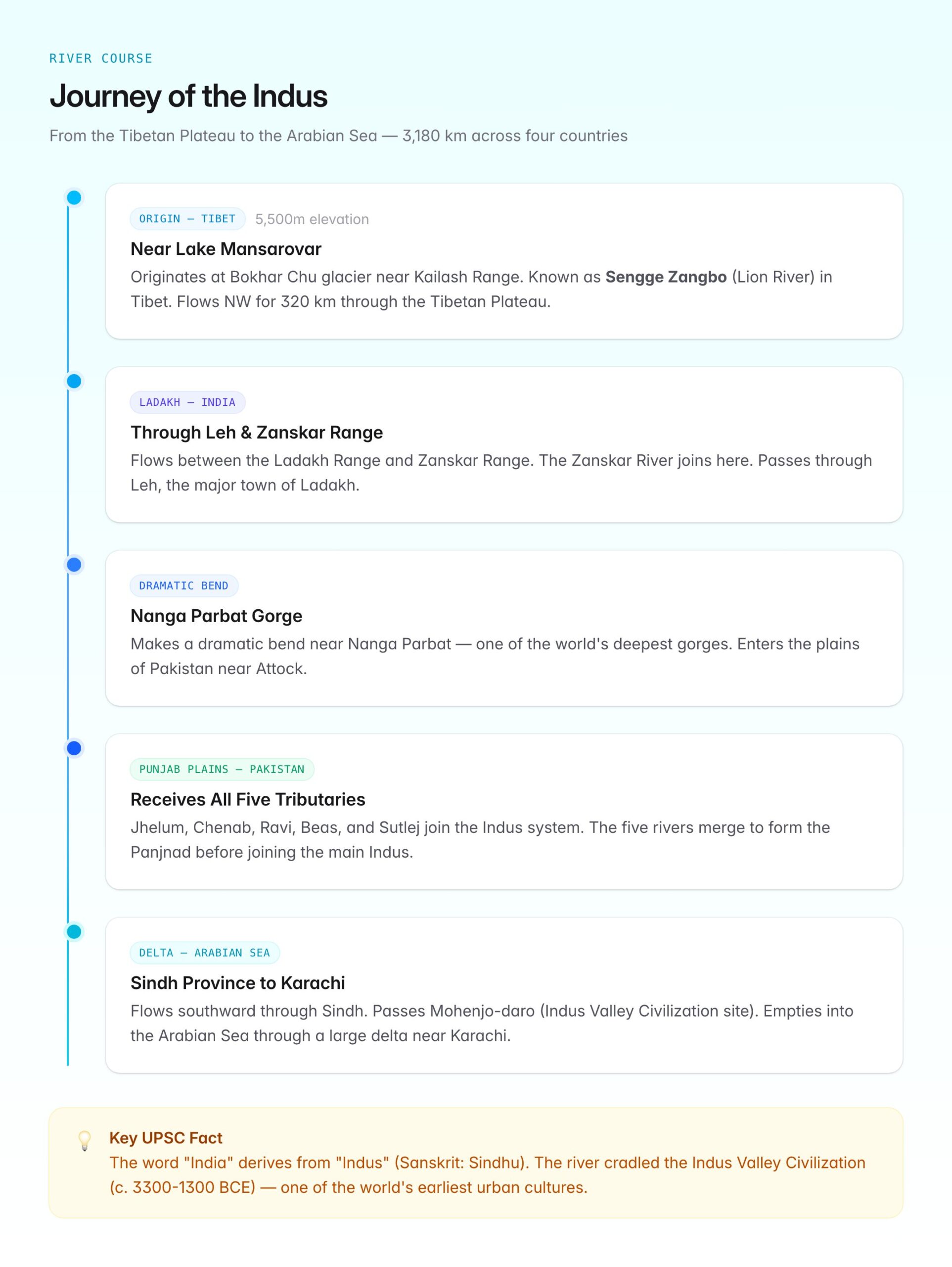
After receiving its major tributaries in Punjab, the Indus flows southward through the provinces of Punjab and Sindh before emptying into the Arabian Sea near Karachi through a large delta.
Total length: Approximately 3,180 km (some estimates put it at 2,880 km), making it one of the longest rivers in Asia.
Drainage basin: About 11.65 lakh sq km, spread across China (Tibet), India, Pakistan, and Afghanistan.
Major Tributaries
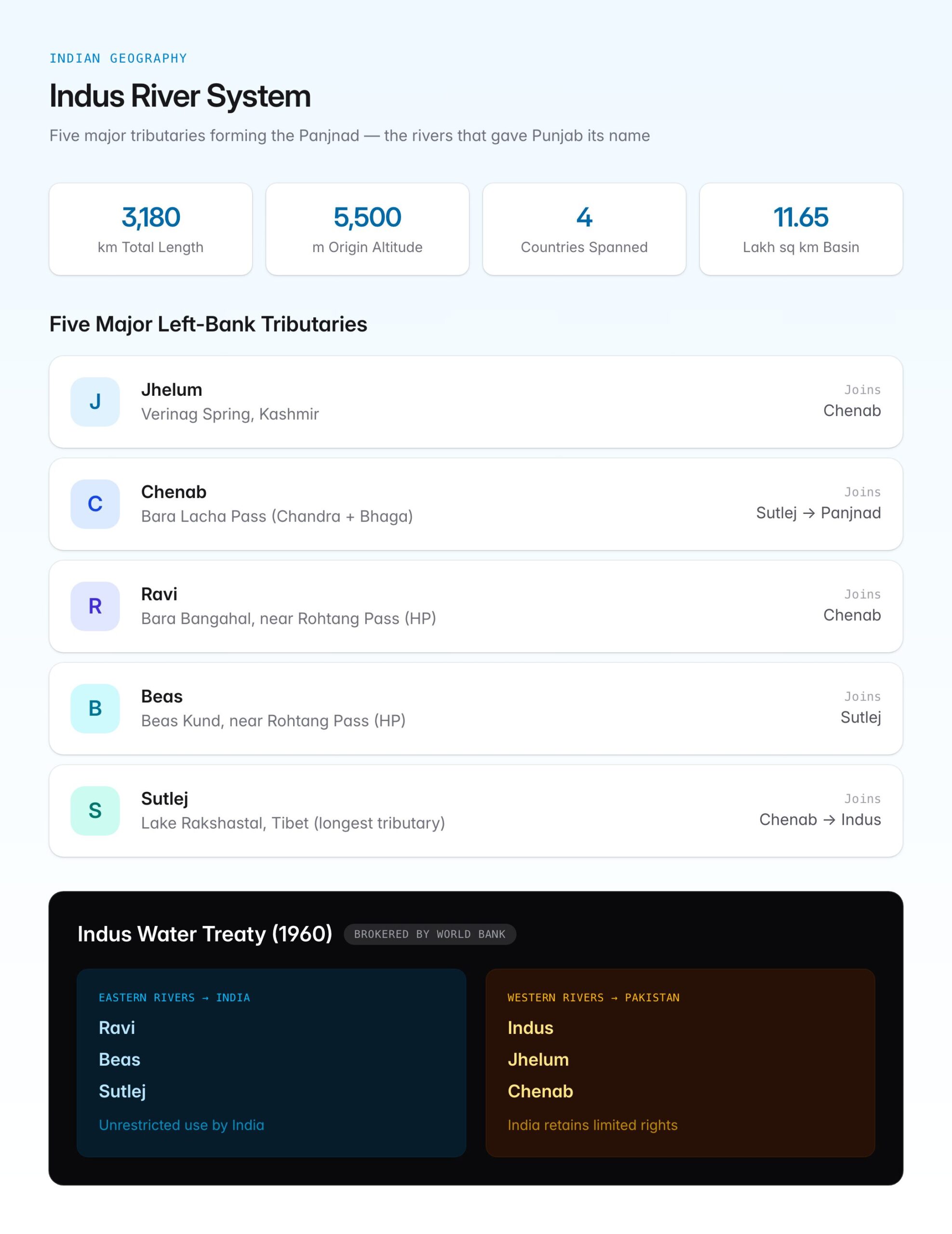
The Indus has five major left-bank tributaries, collectively known as the Panjnad (five rivers), which give the Punjab region its name.
| Tributary | Origin | Joins Indus System |
|---|---|---|
| Jhelum | Verinag Spring, Kashmir | Joins Chenab |
| Chenab | Bara Lacha Pass (Lahaul-Spiti), formed by Chandra and Bhaga rivers | Joins Sutlej to form Panjnad |
| Ravi | Bara Bangahal, near Rohtang Pass (Himachal Pradesh) | Joins Chenab |
| Beas | Beas Kund, near Rohtang Pass (Himachal Pradesh) | Joins Sutlej |
| Sutlej | Lake Rakshastal, near Lake Mansarovar (Tibet) | Joins Chenab (as Panjnad), then joins Indus |
Right-bank tributaries: The major right-bank tributaries include the Shyok, Gilgit, Kabul, Kurram, and Gomal rivers, which join the Indus from the north and west.
Key fact: The Sutlej is the only tributary of the Indus that originates in Tibet, like the main Indus itself.
The Indus Water Treaty (1960)
The Indus Water Treaty is one of the most significant transboundary water-sharing agreements in the world. Signed on 19 September 1960 between India and Pakistan, it was brokered by the World Bank.
Key Provisions
- Eastern Rivers (Ravi, Beas, Sutlej): Allocated to India for unrestricted use.
- Western Rivers (Indus, Jhelum, Chenab): Allocated to Pakistan, though India retains limited rights for domestic use, non-consumptive use (navigation, fisheries), and run-of-the-river hydroelectric projects.
- India can store up to 3.6 million acre-feet (MAF) of water on the western rivers.
- Disputes are resolved through a three-tier mechanism: Permanent Indus Commission (bilateral), Neutral Expert, and Court of Arbitration.
Recent Developments
India issued a notice in 2023 to modify certain provisions of the treaty, citing changes in circumstances since 1960. Pakistan has contested this at the International Court of Justice. The treaty’s future remains a live issue in India-Pakistan relations.
Cities and Important Locations Along the Indus
| City/Location | Country | Significance |
|---|---|---|
| Leh | India | Major town in Ladakh, Indus flows through |
| Skardu | Pakistan-administered Kashmir | Confluence with Shigar River |
| Attock | Pakistan | Historic crossing point, confluence with Kabul River |
| Sukkur | Pakistan | Sukkur Barrage, major irrigation point |
| Mohenjo-daro | Pakistan | Indus Valley Civilization site, near the river |
| Thatta/Karachi | Pakistan | Near the Indus delta, Arabian Sea |
Indus Valley Civilization Connection
The Indus River system nurtured the Indus Valley Civilization (also called Harappan Civilization, c. 3300-1300 BCE), one of the three earliest urban civilizations alongside Mesopotamia and Egypt. Key sites include:
- Mohenjo-daro and Harappa (in present-day Pakistan) on the Indus and Ravi respectively
- Lothal, Dholavira, Rakhigarhi, and Kalibangan in India, mostly along tributaries or the now-dry Ghaggar-Hakra system
The civilization's decline is partly attributed to tectonic shifts that altered river courses, particularly the drying up of the Saraswati/Ghaggar-Hakra system.
Significance of the Indus River
- Agriculture: The Indus basin irrigation system in Pakistan (and parts of India's Punjab, Haryana, and Rajasthan via the Indira Gandhi Canal) supports millions of farmers.
- Hydroelectric potential: India has several hydroelectric projects on the western rivers within treaty limits, including the Baglihar Dam (Chenab) and Kishanganga project (Jhelum).
- Ecology: The Indus Delta was once rich in mangroves and marine life, though it has shrunk significantly due to upstream water diversion.
- Geopolitics: The Indus Water Treaty is a cornerstone of India-Pakistan relations and a rare example of cooperation surviving wars and political crises.
- Cultural identity: The word "India" derives from "Indus," which itself comes from the Sanskrit "Sindhu." The river is integral to the civilizational identity of the subcontinent.
UPSC Relevance
GS Paper I: Indian Geography (Himalayan river systems, drainage patterns), Ancient History (Indus Valley Civilization). GS Paper II: India-Pakistan relations, Indus Water Treaty, transboundary water disputes. GS Paper III: Water resources, irrigation, hydroelectric projects.
Key Prelims facts:
- The Indus originates near Lake Mansarovar in Tibet and flows into the Arabian Sea.
- Total length is approximately 3,180 km; drainage area covers parts of four countries.
- The five major tributaries are Jhelum, Chenab, Ravi, Beas, and Sutlej (left-bank).
- Under the Indus Water Treaty (1960), eastern rivers go to India, western rivers to Pakistan.
- The treaty was brokered by the World Bank.
- Sutlej originates in Tibet (near Lake Rakshastal); it is the longest of the five tributaries.
- The Indus makes a sharp bend near Nanga Parbat in one of the world's deepest gorges.
- Mohenjo-daro is the most famous Indus Valley site located near the Indus River.
Tell Google you want more of this.
Add Anantam IAS as a preferred sourceOne tap, and this site shows up more often in your own Top Stories, AI Overviews and AI Mode. Remove it any time.