Most Populated State in India 2026: Ranking, Density and Key Facts
Most populated state in India 2026: Uttar Pradesh leads by population, with Maharashtra and Bihar next. Full ranking, density, growth rate, and UPSC-ready facts
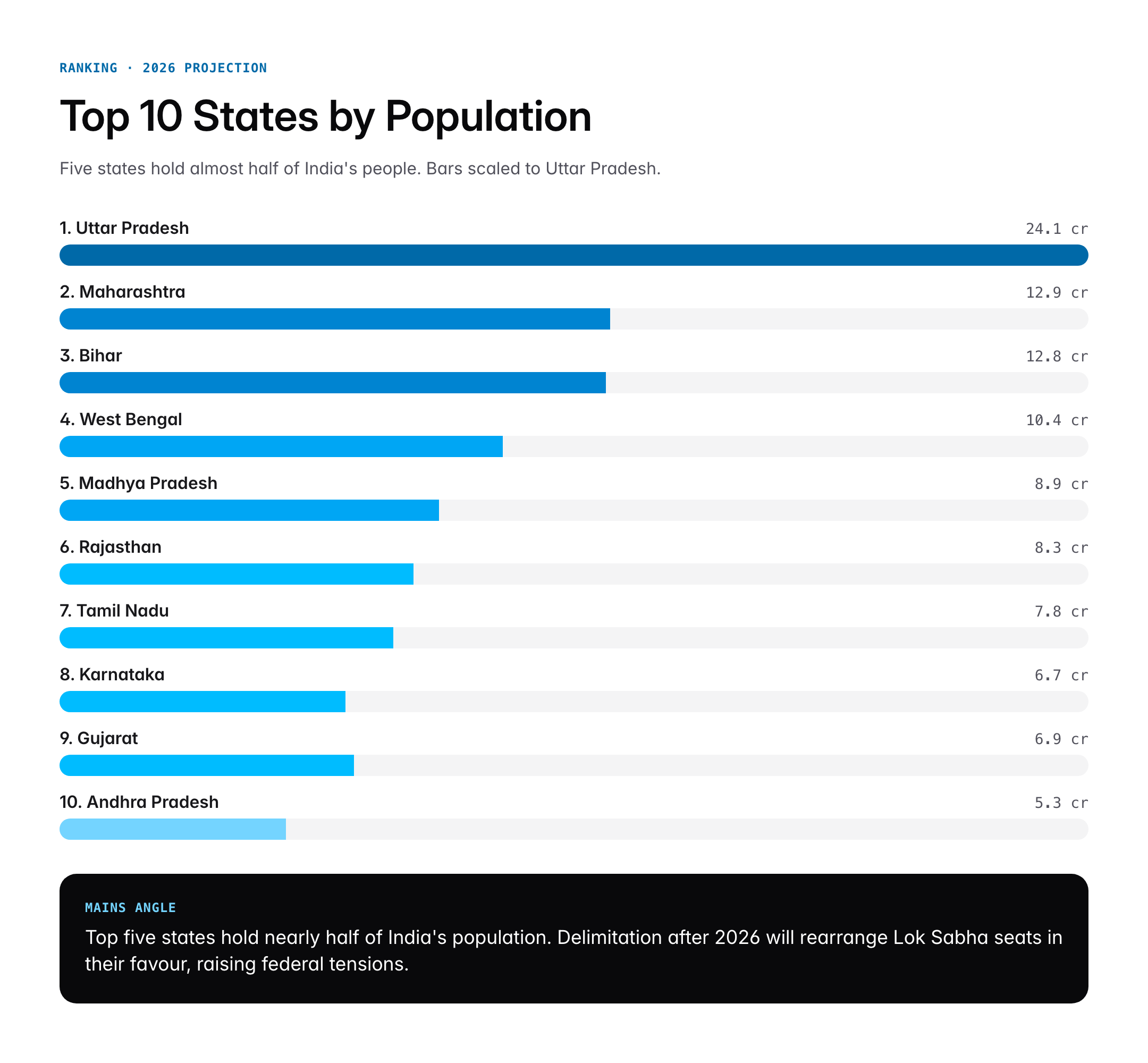
As of 2026, Uttar Pradesh is the most populated state in India, with a projected population of about 24.3 crore (roughly 17% of the country) — per the National Commission on Population’s Technical Group projections built on Census 2011. Maharashtra (~12.9 crore) ranks second and Bihar (~12.8 crore) third; Sikkim (~7.1 lakh) is the least populated state. India’s next Census — its first since 2011 — has been notified for 2027, with 1 March 2027 as the reference date for most of the country.
Introduction
When aspirants ask which is the most populated state in India, the answer has remained consistent for decades: Uttar Pradesh. Home to more people than Brazil or Pakistan, Uttar Pradesh alone accounts for roughly one in six Indians. Understanding state population is not trivia; it shapes parliamentary seat allocation, central tax devolution, health and education planning, and the politics of delimitation.
This guide consolidates the latest projections based on the 2011 Census, the National Population Register update, the Sample Registration System bulletins, and the National Commission on Population’s projected figures for 2026. It ranks every major state, explains why population varies, and pulls out the Prelims and Mains angles a UPSC aspirant must master.
Quick Facts at a Glance
| Metric | Value |
|---|---|
| Most populated state (2026 projection) | Uttar Pradesh |
| UP projected population (2026) | ~24.3 crore |
| Share of India’s population | ~17% |
| Second most populated state | Maharashtra (~12.9 crore) |
| Third most populated | Bihar (~12.8 crore) |
| Least populated state | Sikkim (~7.1 lakh) |
| Highest density state | Bihar (~1,300/km²) |
| National population (2026 projected) | ~141.7 crore |
| Last full Census | 2011 |
| Next Census | 2027 (notified; ref. date 1 March 2027) |
| Data source | Census 2011 + NCP projections 2020 |
Background and Historical Context
India has conducted a decennial Census since 1872, producing the most detailed demographic data of any large country. The 2011 Census recorded a population of 1.21 billion, growing from 1.03 billion in 2001. The next Census was scheduled for 2021 but was postponed due to the COVID-19 pandemic and subsequent revisions. In its absence, population estimates rely on the National Commission on Population’s 2020 projections, the Sample Registration System, and the Civil Registration System.
Within independent India, Uttar Pradesh has been the most populous state at every Census. In 1951 UP’s population was 6.32 crore; by 2011 it reached 19.98 crore; the 2026 projection puts it near 24 crore. The second spot has shifted over decades. In 1951 Bihar was second, but after Jharkhand’s separation in 2000 Bihar slipped behind Maharashtra. After the bifurcation of Andhra Pradesh and Telangana in 2014, the rankings rearranged again, with West Bengal moving up before being overtaken by Bihar in projections.
Demographic transitions have reshaped the regional balance. Southern states such as Tamil Nadu, Kerala, Karnataka, and Andhra Pradesh completed their demographic transition earlier, with total fertility rates falling below 2.0 by the 2000s. Northern and eastern states like Uttar Pradesh, Bihar, Madhya Pradesh, and Rajasthan still have fertility rates above the national average, explaining why their populations continue to grow faster even as national growth slows.
Key Facts on State Population
Population ranking depends on which data source you use. The following subsections explain the authoritative numbers, ranked from the Census 2011 baseline and adjusted through projections.
Uttar Pradesh: The Demographic Giant
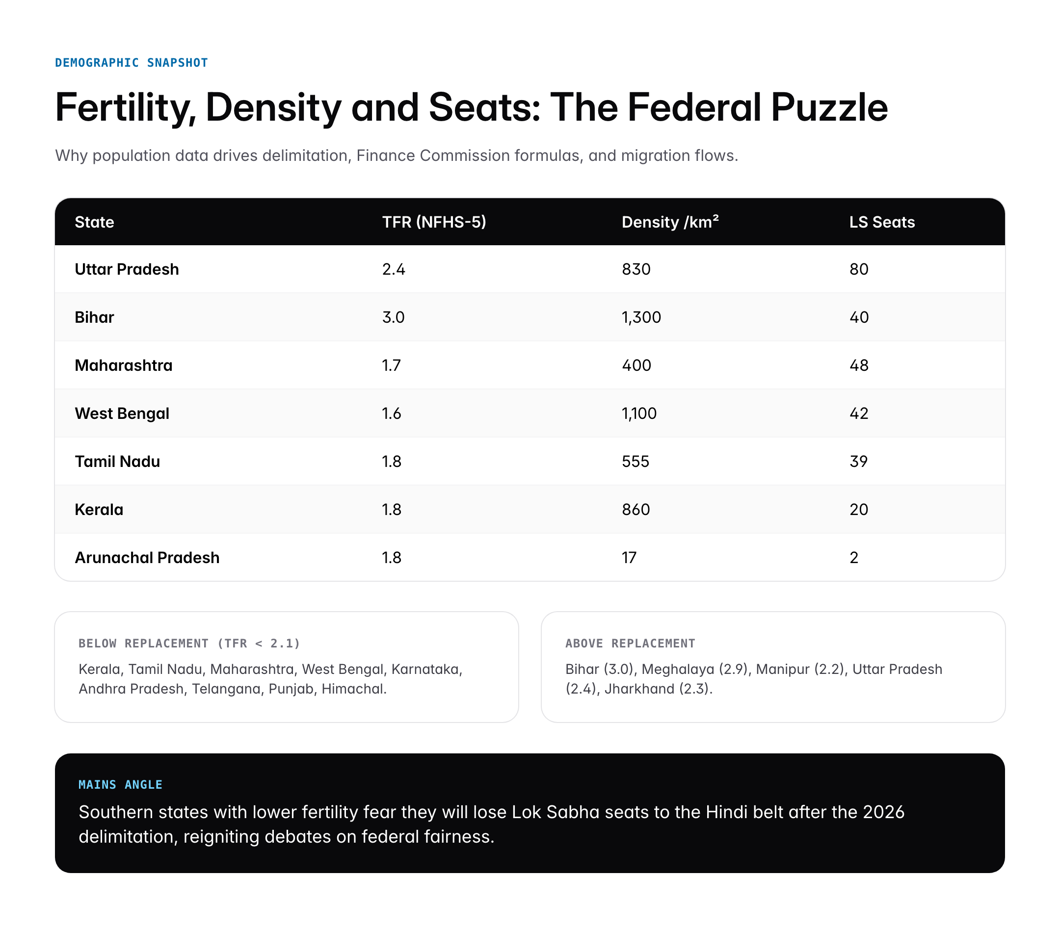
Uttar Pradesh leads with a projected 2026 population around 24 crore. It contains seventy-five districts, a state legislature that is itself bicameral, and eighty Lok Sabha seats out of 543. The state’s population exceeds that of Japan or Russia. Key drivers include a still-high total fertility rate of 2.4 (NFHS-5), large rural share, and relatively slow urbanisation. Its density of about 830 per square kilometre is well above the national average of 482.
Maharashtra: Economic Powerhouse
Maharashtra is the second most populated state with roughly 12.9 crore people by 2026. It hosts Mumbai, the country’s financial capital, and Pune, a major IT and manufacturing hub. In-migration from Uttar Pradesh, Bihar, and eastern India sustains Maharashtra’s demographic weight despite a fertility rate below replacement at 1.7. The state has forty-eight Lok Sabha seats.
Bihar: Rapidly Growing
Bihar holds third place with an estimated 12.8 crore residents in 2026, having narrowly overtaken West Bengal. It has the highest total fertility rate among large states at 3.0 (NFHS-5) and the highest population density of any Indian state. Bihar’s demographic momentum means the state’s share in national seat allocation will rise sharply if and when delimitation is undertaken after the next Census.
West Bengal
West Bengal sits fourth with around 10.4 crore. It combines relatively low fertility at 1.6 with high density, reflecting its historical role as a riverine, agrarian heartland.
Madhya Pradesh, Rajasthan, Tamil Nadu
Madhya Pradesh (8.9 crore), Rajasthan (8.3 crore), and Tamil Nadu (7.8 crore) round out the top seven. Tamil Nadu is notable for completing its demographic transition early, with TFR at 1.8 and one of the best human development indicators among large states.
Least Populated States
At the other end of the scale, Sikkim has the smallest population at roughly 7.1 lakh, followed by Mizoram (12.2 lakh), Arunachal Pradesh (15.7 lakh), and Goa (16 lakh). Among Union Territories, Lakshadweep is smallest with about 70,000 residents.
Significance for UPSC and General Knowledge
- Directly tested in Prelims with questions on rank, density, and growth rate.
- Central to Mains GS1 on demographic dividend, urbanisation, and regional disparities.
- Crucial for GS2 topics on delimitation, federal fiscal transfers, and Finance Commission formulas.
- Underpins debates on population stabilisation, small family norms, and the proposed delimitation freeze extension beyond 2026.
- Connects with NFHS-5 findings on fertility, maternal health, and contraceptive use.
- Useful in essay-type questions on India’s demographic transition and its varied regional pace.
Detailed Analysis: State-wise Distribution
The state-wise distribution of India’s population reveals a structural north-south divide that shapes almost every federal debate. The five most populous states, Uttar Pradesh, Maharashtra, Bihar, West Bengal, and Madhya Pradesh, together account for nearly half of India’s total population. The Indo-Gangetic plain, with its fertile soil and historical agrarian density, remains the demographic centre of gravity. In contrast, the north-eastern states, Himalayan states, and island union territories together constitute less than five percent of the population despite covering a significant land area.
Southern states such as Kerala, Tamil Nadu, Karnataka, and undivided Andhra Pradesh show a different picture. Kerala recorded a total fertility rate below replacement as early as 1988 and is now seeing its working-age population peak. Tamil Nadu followed a similar path, and its 2026 population growth is nearly flat. Telangana, carved out of Andhra Pradesh in 2014, has 3.8 crore residents with Hyderabad alone holding about a quarter of them, illustrating the metropolitan concentration typical of the south.
The north-east tells yet another story. Assam, the most populous in the region, has about 3.6 crore residents; the others range from seven lakh in Sikkim to just over three million in Meghalaya. Population density falls sharply in Arunachal Pradesh (17 per km²) due to mountainous terrain, while Bihar’s 1,300 per km² is among the highest in the world at a state scale.
Urbanisation patterns layer a second dimension. Maharashtra, Tamil Nadu, Gujarat, and Kerala have urban population shares above 45 percent, while Bihar, Assam, and Odisha remain below 25 percent urban. Uttar Pradesh’s size makes it an outlier, large in absolute urban numbers but with only 22 percent urban share. This rural-urban balance feeds directly into schemes like AMRUT, Smart Cities Mission, and PMAY. The NCP projections also show migration flows from the Hindi belt toward Maharashtra, Gujarat, Karnataka, Tamil Nadu, and Delhi continuing at scale through 2030.
Comparative Perspective
A comparative look at the top five states sharpens the picture.
| Rank | State | 2026 Projection (cr) | TFR (NFHS-5) | Density (per km²) | Lok Sabha Seats |
|---|---|---|---|---|---|
| 1 | Uttar Pradesh | 24.3 | 2.4 | 830 | 80 |
| 2 | Maharashtra | 12.9 | 1.7 | 400 | 48 |
| 3 | Bihar | 12.8 | 3.0 | 1,300 | 40 |
| 4 | West Bengal | 10.4 | 1.6 | 1,100 | 42 |
| 5 | Madhya Pradesh | 8.9 | 2.0 | 290 | 29 |
Global comparisons reinforce the scale. Uttar Pradesh alone would rank as the world’s fifth most populous country if it were a nation, larger than Brazil. Bihar is comparable to the Philippines, and Maharashtra to Japan. These comparisons matter when discussing governance capacity, fiscal federalism, and public-service delivery benchmarks.
Challenges and Criticisms
Population distribution creates political and economic tensions. The most contested is delimitation. Constitutional provisions under Articles 81 and 82 require Lok Sabha seats to be allocated based on the latest Census, but the 42nd Amendment froze the total at 1971 levels until the first Census after 2000, extended by the 84th Amendment to 2026. After 2026 delimitation is expected to resume, which would shift seats from southern states that controlled their populations to northern states that grew faster. Tamil Nadu, Kerala, Karnataka, and Andhra Pradesh fear they will be penalised for successful family-planning policies.
A second tension concerns fiscal transfers. The Fifteenth Finance Commission used the 2011 Census for horizontal devolution, with a 12.5 percent demographic performance weight to partly offset the 15 percent weight on population. Southern states still objected. The debate will intensify as state populations drift further apart.
A third issue is data quality. With the 2021 Census postponed, planners have relied on projections that may no longer reflect reality, especially after COVID-19, changes in migration, and unexpected fertility declines. The accuracy of population figures is now itself a policy problem, affecting welfare targeting, PDS coverage, and constituency delimitation.
Prelims Pointers
- Most populated state: Uttar Pradesh (Census 2011 and all projections to 2026).
- Least populated state: Sikkim.
- Most populated UT: Delhi (NCT).
- Least populated UT: Lakshadweep.
- Highest population density state: Bihar.
- Lowest population density state: Arunachal Pradesh.
- Most populous city: Mumbai urban agglomeration.
- UP has 80 Lok Sabha seats, the most of any state.
- National sex ratio (2011): 943 females per 1000 males.
- Kerala has the highest female-to-male sex ratio among major states.
- Tamil Nadu has among the highest life expectancy in India.
- The 84th Amendment froze seat allocation using the 1971 Census until the first Census after 2026.
Mains Practice Questions
Q1. “India’s population distribution is geographically uneven and politically consequential.” Examine in the context of delimitation and fiscal federalism. (250 words)
- Describe north-south demographic divergence and states’ share in national population.
- Link to Article 81/82, 42nd and 84th Amendments, and the 2026 delimitation question.
- Assess Finance Commission devolution weights and southern states’ concerns.
Q2. Discuss the demographic transition among Indian states and its implications for the demographic dividend. (250 words)
- Explain stages of demographic transition with state examples: Kerala, Tamil Nadu (late), UP, Bihar (early-mid).
- Analyse window of demographic dividend and state-level variation in timing.
- Outline policy imperatives for education, skilling, and employment.
Conclusion
Uttar Pradesh’s standing as India’s most populated state is not merely a Census statistic. It frames the political representation of the Hindi belt, the fiscal claims of northern states, the migration economy of cities like Mumbai and Delhi, and the pace at which India as a whole moves through its demographic transition. Together, the top five states hold nearly half the country’s population and shape the rhythm of national policy.
For a UPSC aspirant, state population is a gateway topic. From it you enter debates on federalism, delimitation, urbanisation, and welfare. The specific rankings may shift after the next full Census, but the structural pattern of Uttar Pradesh at the top, the Hindi belt dominating in absolute numbers, and the south leading in demographic modernisation will continue to define India’s policy conversations through the coming decade.
Frequently Asked Questions
What is the most populated state in India?
Uttar Pradesh is the most populated state in India with a projected 2026 population of approximately 24.3 crore, roughly 17 percent of India’s total. It has held this rank at every Census since independence. Maharashtra follows second with around 12.9 crore, and Bihar is third with 12.8 crore according to National Commission on Population projections based on the 2011 Census.
Why is the most populated state in India important for UPSC?
State population rankings are directly tested in Prelims as factual questions on rank, density, and growth, and appear in Mains discussions on delimitation, fiscal federalism, and demographic dividend. Questions on Articles 81 and 82, the 84th Amendment freezing seat allocation, and Finance Commission devolution weights all build on accurate knowledge of state populations.
How is population related to delimitation of Lok Sabha seats?
Articles 81 and 82 require Lok Sabha seats to be allocated among states in proportion to population. The 42nd Amendment froze allocation at 1971 levels, and the 84th Amendment extended this freeze to the first Census after 2026. When delimitation resumes, states with faster population growth like Uttar Pradesh and Bihar are expected to gain seats, while southern states may lose relative share.
Which is the least populated state in India?
Sikkim is the least populated state in India with approximately 7.1 lakh residents. It became the 22nd state of the Indian Union in 1975 through the 36th Constitutional Amendment. Among Union Territories, Lakshadweep is the least populated with about 70,000 residents. Mizoram, Arunachal Pradesh, and Goa are other small-population states.
What is the population density of India’s states?
Bihar has the highest population density among Indian states at about 1,300 persons per square kilometre, followed by West Bengal and Kerala. Arunachal Pradesh has the lowest density at around 17 per square kilometre due to mountainous terrain. The national average density is 482 per square kilometre as per the 2011 Census, one of the highest for a large country.
Why does Uttar Pradesh have such a large population?
Uttar Pradesh’s size reflects its fertile Indo-Gangetic plain, long history of dense agrarian settlement, and a delayed demographic transition. Its total fertility rate remains at 2.4 according to NFHS-5, above replacement level. The state spans 240,928 square kilometres and contains 75 districts, with comparatively slow urbanisation and a still-young age structure driving continued growth.
How do southern states compare to Uttar Pradesh in population?
Southern states completed their demographic transition earlier. Tamil Nadu, Kerala, Andhra Pradesh, and Karnataka all have total fertility rates below 2.0, while Uttar Pradesh remains at 2.4. As a result, southern states’ share of the national population is shrinking in relative terms even as their human development indicators improve, creating tensions over delimitation and fiscal transfers.
When will the next Census happen in India?
The Census of India scheduled for 2021 was postponed due to the COVID-19 pandemic. In June 2025 the Government notified the next Census for 2027: it will run in two phases, with 1 October 2026 as the reference date for the snow-bound areas of Ladakh, Jammu & Kashmir, Himachal Pradesh and Uttarakhand, and 1 March 2027 for the rest of the country. It will be India’s first census since 2011 and its first digital, caste-enumerated count. Until the 2027 figures are released, state population rankings rely on the 2011 Census combined with National Commission on Population projections.