NISAR: The NASA-ISRO Radar Satellite That Will Map Earth Every 12 Days
A complete UPSC GS-III explainer on NISAR, the NASA-ISRO Synthetic Aperture Radar satellite. Covers what synthetic aperture radar actually is, the dual L-band and S-band design, the sun-synchronous orbit and 12-day repeat cycle, the mission's earthquake, glacier, biomass, and agriculture science objectives, the 2025 GSLV-F16 launch, and what the mission means for India's earth-observation programme and US-India space cooperation.
NISAR is the most ambitious earth-observation satellite India has ever helped build. It is also the most expensive joint civilian space mission the United States and India have ever undertaken, with a combined cost north of fifteen thousand crores. The acronym stands for NASA-ISRO Synthetic Aperture Radar, and the partnership is genuinely fifty-fifty, with each agency contributing the parts of the spacecraft they are best at and integrating them into a single platform that sits in low earth orbit and looks down at the planet through clouds, smoke, and darkness.
What makes NISAR distinctive is that it does not take photographs. It uses radar pulses, like an aircraft anti-collision system or a ship’s navigation set, but at a vastly larger scale. Two radars in two different microwave bands look at the same patch of ground, scan the entire globe every twelve days, and detect changes on the surface as small as a few millimetres. The result is a record of how the earth’s crust, ice, forests, and farms move and breathe over time, available to any researcher in the world for free.
For UPSC, NISAR sits at the intersection of space technology, climate science, disaster management, and the geopolitics of US-India scientific cooperation. This article walks through what synthetic aperture radar is and why it matters, the design choices that make NISAR special, the science it will do, the launch and integration story, and what the mission means for India’s earth-observation programme and for the broader ISRO mission portfolio.
What Synthetic Aperture Radar Is
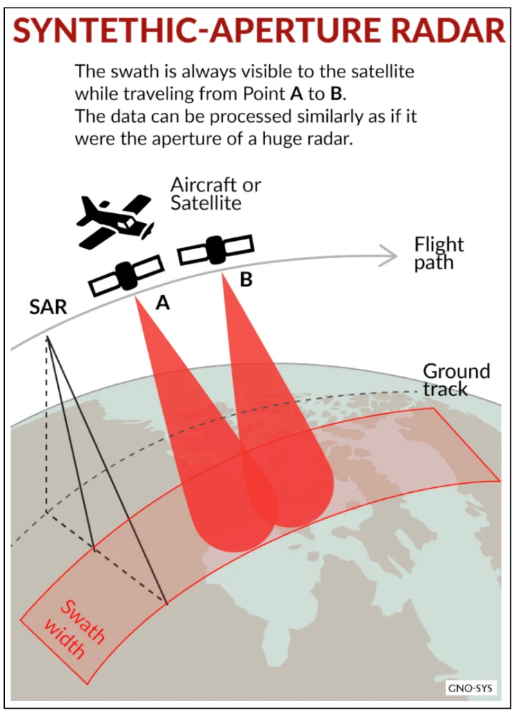
A radar is a device that transmits a microwave pulse, listens for the echo from a distant object, and uses the time delay and frequency shift of the echo to compute the distance and velocity of that object. A synthetic aperture radar takes this further. Instead of a single big antenna staring sideways at the ground, it uses a small antenna mounted on a moving platform, typically a satellite or an aircraft, and combines the echoes received over the platform’s path into a single coherent image. The mathematical post-processing makes the small physical antenna behave as if it were a much larger one. The synthetic aperture is the imaginary giant antenna built up by the platform’s motion.
The advantages of SAR over conventional optical imaging are decisive in many situations. Microwaves penetrate cloud cover, smoke, light rain, and darkness. An optical satellite cannot photograph a flooded city if the city is under cloud, which is exactly when somebody most needs the imagery. A SAR satellite can. Microwaves also reflect differently from rough and smooth surfaces, from wet and dry vegetation, and from snow and ice, which makes SAR sensitive to surface texture and moisture in ways an optical sensor is not. The same physics underpins the RISAT family of Indian radar satellites that have long supported internal security and disaster monitoring.
The disadvantage of SAR is that the imagery is not intuitive. A SAR image looks more like a black-and-white texture map than a photograph. Interpretation requires training. The data volumes are also enormous, and the post-processing is computationally heavy. NISAR will produce roughly eighty terabytes of raw data per day, which is more than any earlier civil earth-observation satellite by a wide margin.
The Dual-Band Design
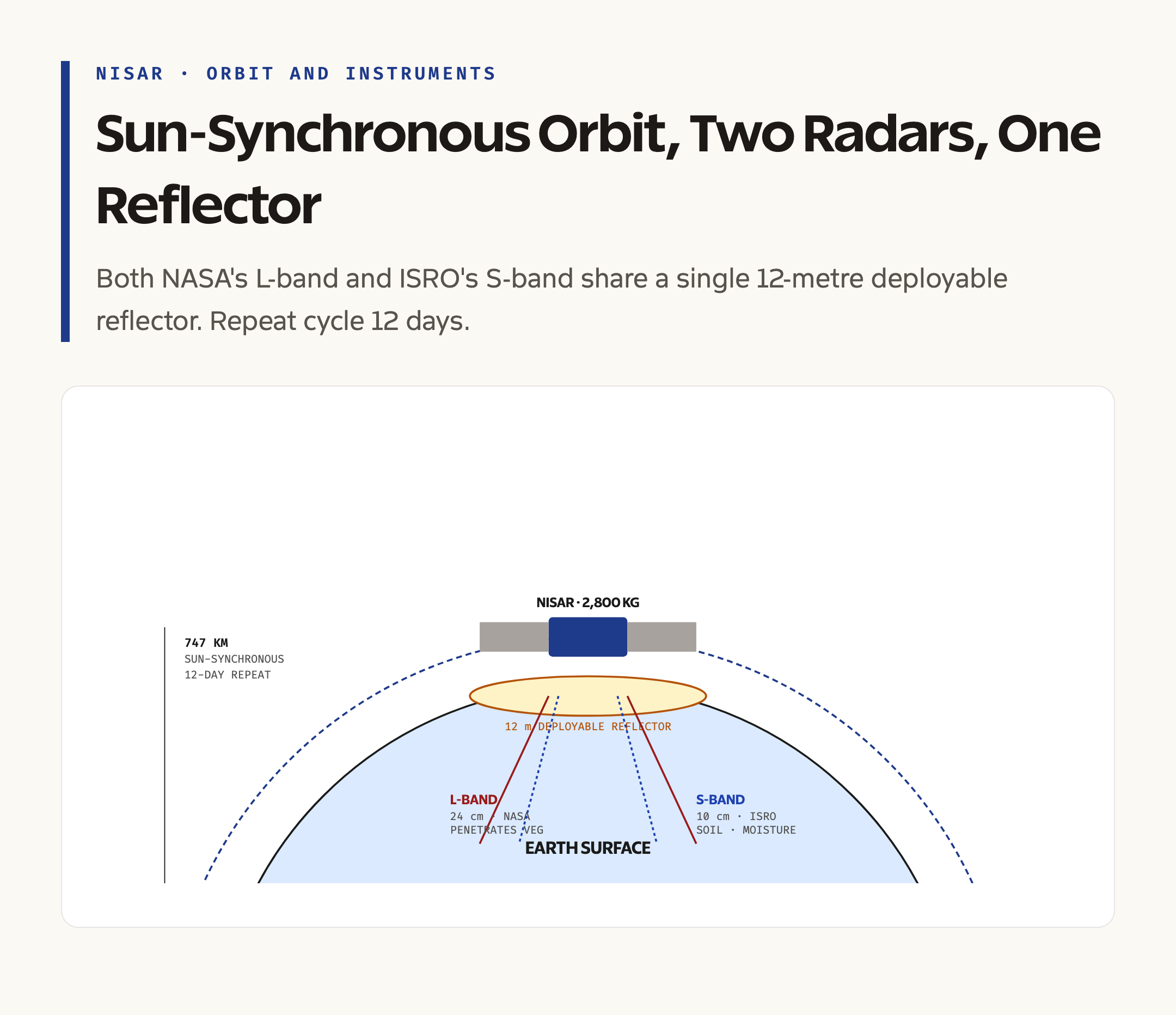
NISAR’s most distinctive feature is that it carries two radars on the same platform. NASA contributes the L-band radar, which operates at a wavelength of about twenty-four centimetres. ISRO contributes the S-band radar, which operates at a wavelength of about ten centimetres. No earlier space-borne SAR has flown both bands on the same satellite.
The reason for the dual band is that different wavelengths interact differently with the surface. L-band, with its longer wavelength, penetrates further into vegetation and soil. It reaches the ground beneath a forest canopy and detects deformation of the crust through layers of trees. It is the right tool for mapping earthquake faults, biomass below the canopy, and ice deformation through fresh snow.
S-band, with its shorter wavelength, scatters more strongly off surface roughness and small features. It is sensitive to soil moisture, the freshness of snow, and the structure of crops. It is the right tool for agricultural monitoring, hydrology, and the topmost layer of vegetation. Used together, the two bands provide a richer picture than either could on its own. A patch of forest, for example, returns a strong S-band echo from the canopy and a strong L-band echo from the trunks and ground, and the ratio between them carries information about biomass that neither band alone could give.
The two radars share a single twelve-metre deployable antenna reflector, the largest such reflector ever flown, which unfurls in orbit like a giant umbrella. The reflector is built by NASA’s Jet Propulsion Laboratory using technology adapted from earlier military satellites. The integration of the two radar feeds onto the same reflector is the central engineering challenge of the mission.
Orbit and Coverage
NISAR flies in a sun-synchronous low earth orbit at an altitude of about 747 kilometres. Sun-synchronous means the satellite passes over each point on the ground at roughly the same local solar time on every orbit. This is convenient for science because the lighting and surface conditions are comparable across observations. The orbit’s inclination is close to ninety-eight degrees, which means it passes nearly pole to pole on each orbit and covers the whole earth as the planet rotates beneath it.
The repeat cycle is twelve days. After twelve days the satellite has covered every point on the earth’s land surface and selected ocean regions, and it begins again on the same ground track. This is shorter than most earlier SAR satellites and is what allows NISAR to detect changes on the time scale of weather events, slow-moving landslides, glacier seasonal cycles, and crop growth.
The mission’s design lifetime is at least three years, and the swath width and orbit allow each pass to image roughly 240 kilometres across the ground at a spatial resolution of three to ten metres depending on the operating mode. The combination of swath, resolution, and repeat cycle is what makes NISAR a globally consistent monitoring instrument rather than a targeted one.
The Science Objectives
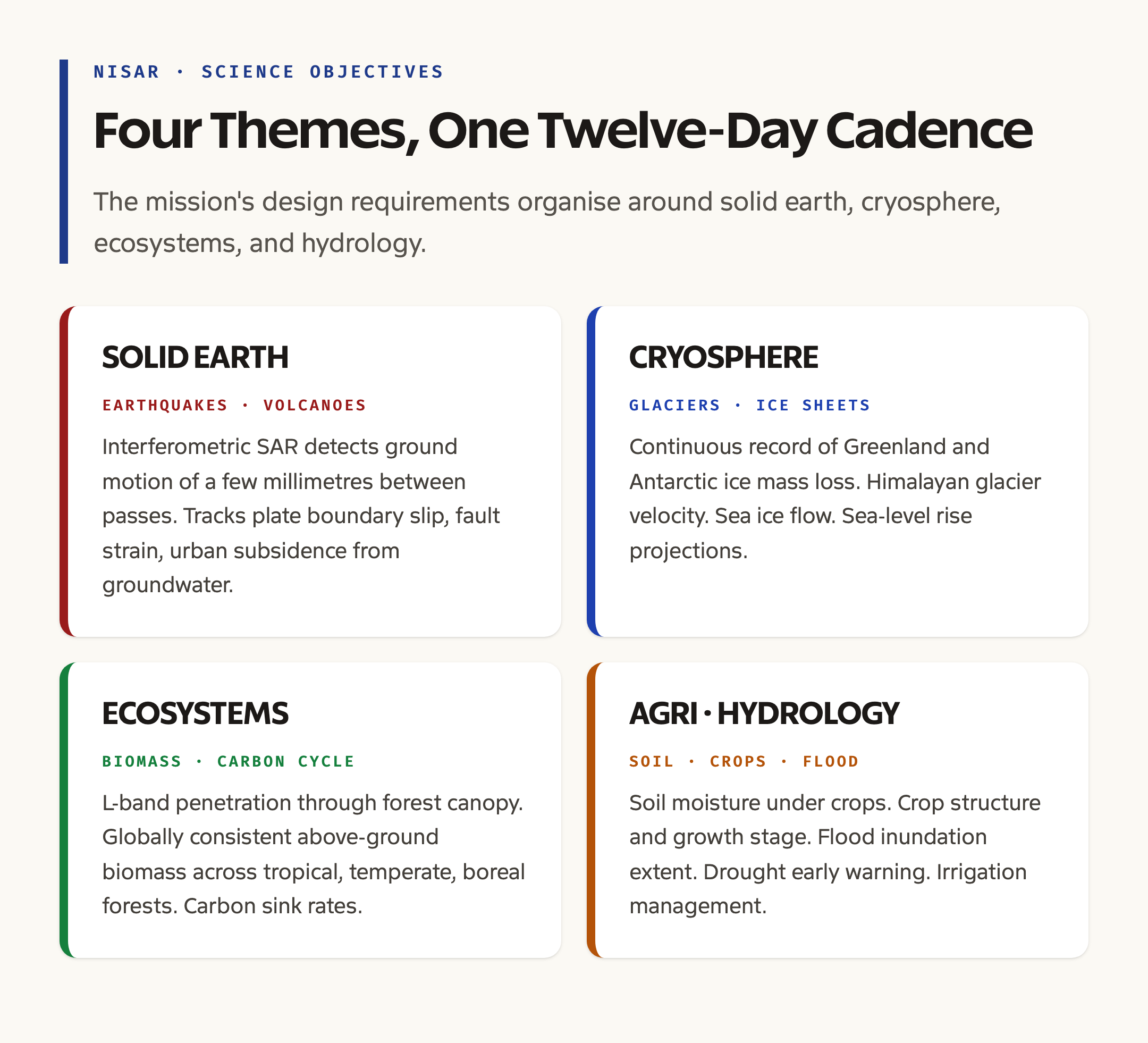
NISAR’s science programme is organised around four broad themes that are written into the mission’s instrument requirements. The first is solid earth science. NISAR will measure crustal deformation associated with earthquakes, volcanoes, and slow tectonic motion. By comparing radar phase between two passes over the same area, the technique called interferometric SAR can detect ground motion of a few millimetres. This is the right tool for tracking slip on plate boundaries, for monitoring the strain accumulating on a fault before an earthquake, and for measuring subsidence in cities where groundwater extraction is causing the surface to sink.
The second is the cryosphere. NISAR will track the motion of glaciers and ice sheets, the flow of sea ice, and the seasonal advance and retreat of snow cover. The mission will provide a continuous record of how the Greenland and Antarctic ice sheets are losing mass, which is the largest source of uncertainty in projections of sea-level rise.
The third is ecosystems and biomass. The L-band penetration into forest canopy allows NISAR to estimate above-ground biomass over the world’s tropical, temperate, and boreal forests. This matters for the carbon cycle. Forests are the largest terrestrial carbon sink, and the rate at which they are gaining or losing carbon is one of the central unknowns in climate science. NISAR will provide a globally consistent measurement.
The fourth is agriculture and hydrology. The combination of L-band and S-band makes NISAR sensitive to soil moisture under crops, to the structure and growth stage of crops themselves, and to the extent of inundation in flooded regions. This has obvious applications for early warning of drought and flood, for crop yield forecasting, and for the management of large irrigation systems.
Indian Applications
For India specifically, the data has several immediate applications. The country’s monsoon-fed agriculture, with its sensitivity to soil moisture and rainfall variability, will benefit from twelve-day soil moisture maps at three to ten metre resolution. The Ministry of Agriculture and the various state remote-sensing applications centres are expected to integrate NISAR data into their crop forecasting systems.
The Himalayan glaciers, which are the source of most of the country’s perennial rivers, will be tracked at a resolution that earlier satellites could not match. The combination of seasonal velocity measurements and ice-sheet mass change estimates will improve hydrological modelling for the Indus, Ganga, and Brahmaputra basins.
The seismic hazard mapping along the Himalayan front, where a major earthquake is overdue, will benefit from interferometric measurements of crustal strain accumulation. NISAR will be the first satellite to provide such measurements at a temporal cadence that reveals seasonal as well as longer-term variation.
Disaster response will be a routine application. After every major flood, landslide, earthquake, or cyclone, NISAR’s all-weather imaging will allow the National Disaster Management Authority and ISRO’s National Remote Sensing Centre to map the affected area within a few days, regardless of cloud cover.
Launch and Integration
The integration of NISAR was a long and complex piece of work. The L-band SAR was built at NASA’s Jet Propulsion Laboratory in Pasadena. The S-band SAR was built at ISRO’s Space Applications Centre in Ahmedabad. The bus, which is the spacecraft platform that carries the radars, was built at the U.R. Rao Satellite Centre in Bengaluru. The deployable reflector and feed assembly came from NASA. The two science instruments and the bus were brought together for final integration at Bengaluru in 2024, where the spacecraft was tested as a complete system before being shipped to Sriharikota.
The launch vehicle is the GSLV-F16, an upgraded variant of the Geosynchronous Satellite Launch Vehicle Mark II. The choice is appropriate because the spacecraft mass, close to twenty-eight hundred kilograms, exceeds the capacity of the smaller PSLV. The launch took place from the Satish Dhawan Space Centre at Sriharikota in 2025. The cryogenic upper stage placed the satellite into a transfer orbit, and the spacecraft used its own propulsion to circularise into the operational orbit.
The first six months of the mission were devoted to commissioning. The reflector deployment, the radar calibration, and the data downlink chain to ground stations in California and Bengaluru were all checked. Routine science operations began in the second half of 2025, and the data became publicly available through both NASA’s Alaska Satellite Facility and ISRO’s Bhuvan portal in early 2026.
Why NISAR Is a Diplomatic Milestone
The NASA-ISRO partnership on NISAR began with an exchange of letters in 2014 and was formalised through a series of agreements over the following decade. It is the largest collaborative civilian space project the two agencies have undertaken. The fifty-fifty division of work, the joint integration in Bengaluru, the launch on an Indian rocket, and the shared data release model all set precedents that subsequent collaborations have followed.
It also marks a maturation of India’s earth-observation programme. ISRO’s IRS series, the Cartosat satellites, the RISAT family, and the more recent EOS series have given India one of the largest civilian remote-sensing constellations in the world. NISAR adds a class of measurements that none of those satellites alone could provide, and it does so as a peer-level partner of NASA rather than as a customer or a junior collaborator.
The mission’s scientific output is in the public domain, available to researchers in any country. The Indian and US science teams retain rights to the prime data products, but the underlying observations are open. This open-data model is one of the most consequential elements of the partnership, because it ensures that the investment generates scientific returns far beyond either country’s borders.
What Comes Next

NISAR is expected to operate for at least three years, with consumables and on-orbit performance suggesting that an extended mission to five years or more is feasible. During that period it will produce the most detailed continuous record of earth’s surface dynamics ever assembled. The mission also creates a template for follow-on collaborations, including a possible second-generation dual-band SAR in the early 2030s.
For the broader Indian programme, the mission feeds into the next generation of operational earth-observation satellites planned under the Earth Observation System architecture, into the climate modelling work of the Indian Institute of Tropical Meteorology and the Ministry of Earth Sciences, and into the disaster management coordination led by the NDMA. The data will outlive the satellite. Decades from now, NISAR’s twelve-day record from 2025 to the early 2030s will be the baseline against which subsequent change is measured.
Frequently Asked Questions
What does NISAR stand for?
NISAR stands for NASA-ISRO Synthetic Aperture Radar. It is a joint satellite mission of the United States and Indian space agencies that uses two radar instruments to map earth’s surface every twelve days. The mission is the largest civilian space cooperation between NASA and ISRO and was launched on a GSLV-F16 from Sriharikota in 2025.
Why does NISAR use two radar bands?
NISAR carries an L-band radar provided by NASA and an S-band radar provided by ISRO. L-band has a longer wavelength and penetrates vegetation and soil to detect crustal deformation and biomass below forest canopy. S-band has a shorter wavelength and is sensitive to surface moisture, snow, and crop structure. Together they provide a richer picture than either band alone.
What orbit does NISAR fly in?
NISAR operates in a sun-synchronous low earth orbit at an altitude of about 747 kilometres, with an inclination near ninety-eight degrees. The orbit allows the satellite to pass over each point at the same local solar time on every revisit. The repeat cycle is twelve days, meaning every point on the earth’s land surface is imaged again twelve days later.
What science will NISAR do?
NISAR’s four science themes are solid earth dynamics, including earthquakes and volcanoes; the cryosphere, including glaciers and ice sheets; ecosystems and biomass, especially carbon storage in forests; and agriculture and hydrology, including soil moisture and crop monitoring. The mission will also support disaster response by mapping floods, landslides, and earthquake damage through cloud cover.
When did NISAR launch and how long is the mission?
NISAR launched in 2025 on a GSLV-F16 from the Satish Dhawan Space Centre at Sriharikota. The minimum mission duration is three years, with consumables and on-orbit performance suggesting an extended life of five years or more. Routine science operations began in the second half of 2025 after a six-month commissioning phase.