Satpura Mountain Range: The Block Mountain Wall Between Narmada and Tapi
Satpura Mountain Range is a block mountain system across MP, Maharashtra, Gujarat. Separates Narmada and Tapi valleys. Peaks, sub-ranges, geology, UPSC notes.
The Satpura Mountain Range is one of those Indian features that everyone has heard of and almost no one can describe accurately. The standard textbook line, that it separates the Narmada from the Tapi, is correct but not enough. The Satpura Mountain Range is actually a chain of block mountains running roughly nine hundred kilometres across central India, from the Rajpipla hills in eastern Gujarat in the west, through the Maharashtra-Madhya Pradesh border, across the Mahadeo and Maikal sub-ranges, all the way to the Chhotanagpur plateau in the east. It is the southern wall of the Narmada valley and the northern wall of the Tapi valley, and its geological story explains a lot about why central India looks the way it does.
For UPSC aspirants, the Satpura Mountain Range is the single most heavily examined block mountain system on the Indian Peninsula. It shows up in Prelims (peaks, sub-ranges, states), in Mains Geography (drainage divides, geological evolution), and in Environment (national parks, tribal landscape). It also anchors the standard Vindhya-Narmada-Satpura-Tapi-Maharashtra plateau cross section that one is expected to be able to sketch.
This piece walks through the range’s location, geology, sub-ranges, peaks, rivers, ecology, and the cultural and administrative footprint it leaves on central India.
Quick Facts at a Glance
- Type: Block mountain (horst), formed by faulting
- Length: Approximately 900 km from east to west
- States covered: Gujarat, Maharashtra, Madhya Pradesh, Chhattisgarh (with eastern extension)
- Major sub-ranges: Rajpipla Hills, Gawilgarh Hills, Mahadeo Hills, Maikal Range
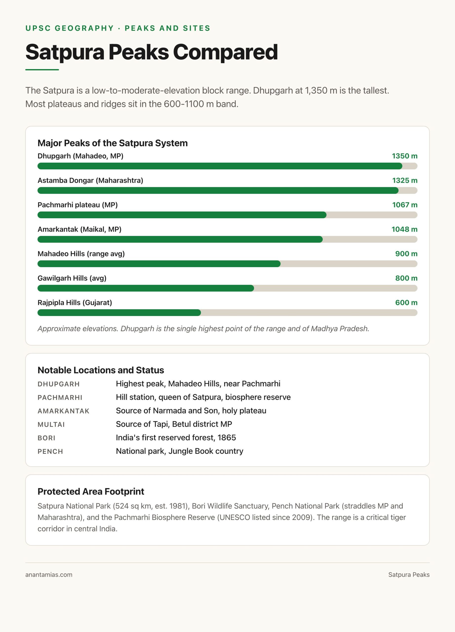
- Highest peak: Dhupgarh (1,350 metres), in the Mahadeo Hills near Pachmarhi
- Other notable peaks: Astamba Dongar, Mahendragiri (do not confuse with Odisha’s), Amarkantak (1,048 m)
- Rivers it separates: Narmada (to the north) and Tapi (to the south)
- Rivers that rise in the range: Narmada (at Amarkantak), Son, Mahanadi (Maikal), Tapi (Multai), Wainganga
- Major hill station: Pachmarhi (Madhya Pradesh)
- National parks: Satpura, Pench, Bori, Pachmarhi Biosphere Reserve
- Geological era: Pre-Cambrian crystalline base with Gondwana-period uplift; ranges among the oldest in India
- Tribal heartland of: Gond, Korku, Bhil communities
Where Is the Satpura Mountain Range
The Satpura Mountain Range runs roughly east-west across central India. The westernmost end touches eastern Gujarat in the Rajpipla and Surat districts, where it descends towards the Arabian Sea coastal plain. From there it stretches eastward through the northern frontier of Maharashtra (Nandurbar, Dhule, Amravati, Nagpur districts), the southern half of Madhya Pradesh (Khandwa, Khargone, Betul, Chhindwara, Hoshangabad, Pachmarhi area), and onward through the Maikal hills into Chhattisgarh’s Bilaspur and Raipur districts. The eastern terminus merges into the Chhotanagpur plateau.
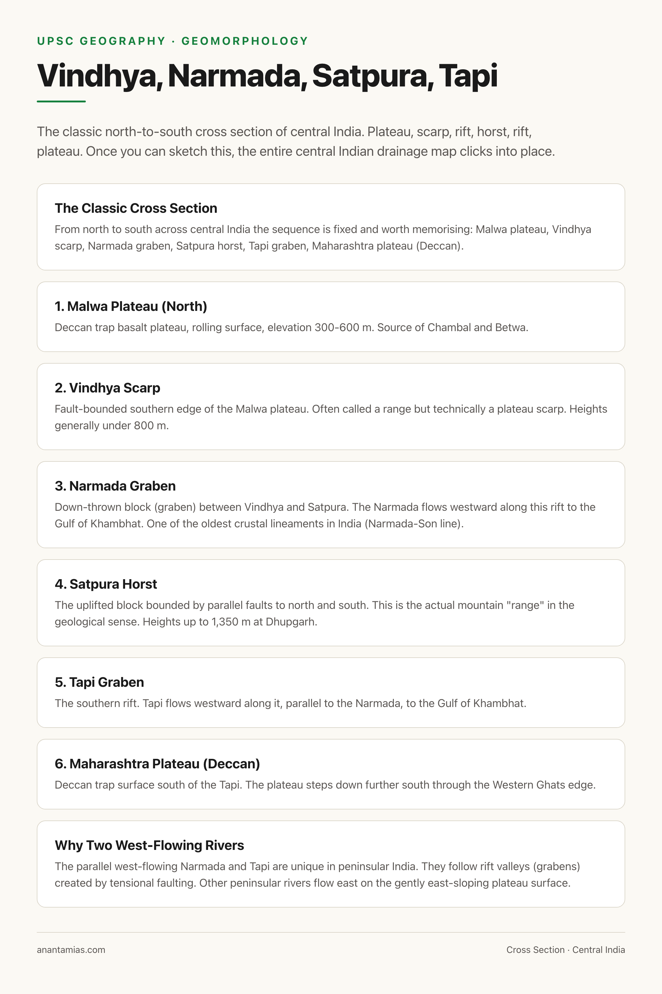
The Narmada River flows along the entire northern foot of the Satpura range, between the Vindhyas to the north and the Satpura to the south, in a rift valley called the Narmada graben. The Tapi River flows along the southern foot, in a parallel rift valley called the Tapi graben. The Satpura between the two is the classic horst, an uplifted block bounded by parallel faults. For broader background, see our piece on mountains of India and rivers of India.
Background and Historical Context
Geological Origin of the Satpura Range
The Satpura Mountain Range is part of one of the oldest landforms on the Indian Peninsula. The base rocks are Pre-Cambrian crystalline gneisses and granites, capped in many parts by the Deccan Trap basaltic flows from the late Cretaceous to early Eocene (around 66 million years ago, contemporary with the Cretaceous-Paleogene boundary).
The defining geological event is the Gondwana-era and post-Gondwana faulting that created the modern Narmada-Tapi rift system. The Narmada-Son lineament is one of the oldest and deepest crustal sutures in India, running across the peninsula. The Satpura horst was uplifted between two parallel rift faults, the Narmada fault to the north and the Tapi fault to the south. This is why the Satpura is classified as a block mountain rather than a fold mountain. Fold mountains form by compressional plate collision (like the Himalayas). Block mountains form by tensional faulting that lifts a crustal block (a horst) between two down-thrown blocks (grabens).
This geological character gives the Satpura its distinctive profile: relatively flat-topped, with steep north-facing scarps overlooking the Narmada valley, lower and more gradual on the southern face towards the Tapi. The flat tops are remnants of the original peninsular plateau surface, lifted but not folded.
For the broader peninsular context, see our explainer on the peninsular plateau and the parallel southern uplift covered in Western Ghats.
Sub-Ranges and Peaks
Conventionally the Satpura Mountain Range is divided into four sub-ranges from west to east.
Rajpipla Hills
The westernmost segment, in eastern Gujarat across Bharuch, Narmada, Surat districts. Elevations are modest (200 to 700 metres). These hills descend westward into the coastal Gujarat plain and the Gulf of Khambhat. The Narmada cuts through here in its lower reaches before emptying into the Arabian Sea.
Gawilgarh Hills
The central-western segment, lying mostly in Maharashtra’s Amravati district and southern Madhya Pradesh. The historic fort of Gawilgarh (Gawilghur) sits here. The Berar plateau lies just south. These hills are notable for the cotton-growing belt below them.
Mahadeo Hills
The central segment, lying in Madhya Pradesh between the upper Narmada and the upper Tapi. The hill station of Pachmarhi (called the “queen of Satpura”) is located here at about 1,067 metres. The Mahadeo Hills hold the highest peak of the entire range:
- Dhupgarh (1,350 metres): The highest point in Madhya Pradesh and in the Satpura range overall. Located near Pachmarhi. The name means “hill of the sun” and the summit is a popular sunset viewpoint.
Maikal Range
The eastern segment, running northeast-southwest across the Madhya Pradesh-Chhattisgarh border. The Maikal is notable because it is where the Satpura system bends and connects to the Chhotanagpur plateau. The Maikal also holds:
- Amarkantak (1,048 metres): A holy plateau where the Narmada and Son rivers rise, and a major Hindu pilgrimage centre.
- Bhanrer Range, Kaimur Range: Sometimes treated as part of the Vindhya system but transitional to the Maikal.
For peak heights memorisation, the standard UPSC list is Dhupgarh first, then Astamba Dongar in Maharashtra (around 1,325 metres, the highest in Maharashtra’s Satpura section), then Amarkantak as the famous river-source plateau even though it is not the highest.
Rivers Associated with the Satpura
The Satpura Mountain Range is a continental drainage divide for central India. Six major rivers are tied to it.
- Narmada: Rises at Amarkantak in the Maikal sub-range, flows westward in the Narmada graben between Vindhya and Satpura, empties into the Gulf of Khambhat. Length about 1,312 kilometres. Read more on the Narmada River.
- Tapi: Rises at Multai in the southern Satpura slopes in Madhya Pradesh, flows westward in the Tapi graben to the south of Satpura, empties into the Gulf of Khambhat at Surat. Length about 724 kilometres.
- Son: Rises near Amarkantak, flows northward to join the Ganga in Bihar.
- Mahanadi: Rises in the Maikal range in Chhattisgarh, flows eastward into the Bay of Bengal.
- Wainganga: Rises in the southern Satpura in Madhya Pradesh, flows south as a major tributary of the Godavari.
- Indravati: Rises in the eastern Satpura-Chhotanagpur transition, flows west into the Godavari.
The pattern is unusual. The Narmada and Tapi both flow westward, almost parallel, into the Arabian Sea. Most other peninsular rivers flow east. This west-flowing pattern is a direct consequence of the Satpura horst sitting between two parallel rift valleys. There is no other region in peninsular India where two long rivers flow west in parallel.
Climate and Vegetation
The Satpura Mountain Range has a tropical climate that grades with elevation. The higher sections (Mahadeo Hills, Maikal) get up to 1,500 mm of annual rainfall from the southwest monsoon. The lower western sections (Rajpipla) are drier, around 700 mm.
Forest cover is dense in the central and eastern sections. The dominant types are:
- Tropical dry deciduous forest: Teak (Tectona grandis), sal in the eastern parts, mahua, tendu, bamboo.
- Tropical moist deciduous forest: In wetter pockets of the Mahadeo Hills and Maikal.
- Semi-evergreen patches: At higher elevations near Pachmarhi.
Major protected areas include Satpura National Park (Madhya Pradesh, around 524 sq km, declared 1981), Bori Wildlife Sanctuary (one of the oldest reserved forests in India, declared 1865), Pachmarhi Biosphere Reserve (UNESCO biosphere reserve since 2009), and Pench National Park (straddling MP-Maharashtra, made famous by Rudyard Kipling’s Jungle Book). The range is a key tiger habitat and an important corridor in central India’s Project Tiger landscape.
Tribal and Cultural Geography
The Satpura Mountain Range is the heartland of central India’s tribal belt. The Gond (the largest Scheduled Tribe in India by population), the Korku, the Bhil, the Baiga, and several smaller communities live across its slopes and forests. The Gond kingdom of Garha-Mandla, which controlled much of the central Satpura region until the eighteenth century, ruled from the Maikal foothills. The Bhil communities are concentrated in the western Satpura into eastern Gujarat.
Pachmarhi, the only proper hill station in the range, sits on a plateau at about 1,067 metres in the Mahadeo Hills. It was developed by Captain James Forsyth in 1857 and served as a summer capital of the Central Provinces under the British.
The range is also dotted with rock shelters and prehistoric paintings. The Bhimbetka rock shelters (a UNESCO World Heritage Site) sit just north of the Satpura at the southern foot of the Vindhyas, but the cultural continuum extends into the Satpura. Pachmarhi itself has multiple painted rock shelters dating from the Mesolithic onward.
Comparing Satpura with Vindhya
A common UPSC and school question is the difference between the Vindhya and Satpura ranges. They look similar from a distance but have important differences.
| Feature | Vindhya Range | Satpura Range |
|---|---|---|
| Type | Scarp of the Malwa plateau, partly fault-bounded | Block mountain (horst) |
| Position | North of Narmada | South of Narmada (and north of Tapi) |
| Extent | Roughly 1,050 km, mostly MP and parts of Rajasthan, Gujarat, UP | Roughly 900 km, MP, Maharashtra, Gujarat, Chhattisgarh |
| Highest peak | Sad-bhawna Shikhar (around 752 m); the Vindhyas are generally lower | Dhupgarh (1,350 m), considerably higher |
| Major rivers rising | Chambal, Betwa, Ken, Son (south slope) | Narmada (Amarkantak), Tapi (Multai), Mahanadi, Wainganga |
| Geological character | Plateau scarp dissected by streams | Faulted horst between Narmada and Tapi grabens |
| Cultural anchor | Northern frontier of Deccan | Tribal central India heartland |
The single biggest takeaway: Vindhyas are essentially a scarp of the Malwa plateau, while Satpuras are a proper uplifted block. That is why Satpura peaks are higher even though both sit on the same broad peninsular plateau.
Economic and Strategic Significance
The Satpura Mountain Range is economically significant for several reasons.
- Mineral wealth: Coal in the Korba-Chirimiri belt and Pench valley; manganese in the Balaghat zone of the Maikal; bauxite at Amarkantak; iron in parts of the eastern Maikal.
- Forestry: Teak, sal, bamboo, tendu (for bidi leaves), mahua. The Bori Reserved Forest was the first in India.
- Hydropower and irrigation: The Tawa dam on the Tawa (Narmada tributary), the Bargi dam upstream, Indira Sagar and Sardar Sarovar on the Narmada itself, and a series of Tapi-system dams all use the gradient created by the Satpura escarpments.
- Agriculture: The southern Satpura foothills are part of the cotton belt of Vidarbha. The northern foot, the Narmada valley, is a wheat and pulse belt.
- Tourism: Pachmarhi, Satpura tiger reserves, Amarkantak pilgrimage, and the Bhimbetka complex draw substantial domestic tourism.
Prelims Pointers
- The Satpura Mountain Range is a block mountain (horst) formed by faulting.
- It runs roughly east-west for about 900 km.
- It passes through Gujarat, Maharashtra, Madhya Pradesh, and Chhattisgarh.
- Dhupgarh (1,350 m) in the Mahadeo Hills near Pachmarhi is the highest peak.
- The Narmada flows along its northern foot; the Tapi flows along its southern foot.
- The Narmada rises at Amarkantak in the Maikal sub-range.
- The Tapi rises at Multai in the southern Satpura slopes.
- Four sub-ranges from west to east: Rajpipla, Gawilgarh, Mahadeo, Maikal.
- Pachmarhi (about 1,067 m) is the only hill station in the Satpura range.
- The Satpura National Park, Bori Sanctuary, and Pench National Park are key protected areas.
Mains Practice Questions
- Account for the parallel west-flowing course of the Narmada and Tapi rivers and explain the role of the Satpura Mountain Range in shaping this drainage pattern. (10 marks)
- Compare and contrast the Vindhya and Satpura ranges with reference to geological origin, elevation, and drainage. (15 marks)
- Examine the significance of the Satpura Mountain Range as the ecological and cultural backbone of central India. (15 marks)
- Discuss the resource base of the Satpura belt and the challenges of balancing tribal welfare, forest conservation and mining-led development. (15 marks)
Why the Satpura Range Still Matters
The Satpura Mountain Range is not the highest or the most dramatic range in India. The Himalayas dwarf it, the Western Ghats are more biodiverse, even the Aravallis are older. But Satpura is the structural keel of central India. It separates two great rift-valley rivers, it provides the headwaters for several others, it sustains India’s largest tribal belt, and it forms the geological boundary between the Indo-Gangetic North and the Deccan South.
For UPSC, the Satpura Mountain Range is the single best example of a peninsular block mountain. It connects geomorphology (horst-graben), drainage (Narmada-Tapi divide), ecology (central Indian tiger landscape), economy (cotton, coal, teak), and culture (Gond and Bhil heartland) in one feature. Mastering it covers a surprisingly wide spread of the GS-1 Geography syllabus.
Frequently Asked Questions
What is the Satpura Mountain Range?
The Satpura Mountain Range is a block mountain system running roughly 900 kilometres east-west across central India through Gujarat, Maharashtra, Madhya Pradesh, and Chhattisgarh. It separates the Narmada River valley to its north from the Tapi River valley to its south.
Is the Satpura a fold mountain or a block mountain?
The Satpura is a block mountain, specifically a horst. It was formed by the uplift of a crustal block between two parallel rift faults, the Narmada fault to the north and the Tapi fault to the south. It is not a fold mountain like the Himalayas.
Which is the highest peak of the Satpura range?
The highest peak is Dhupgarh at 1,350 metres, located in the Mahadeo Hills near the hill station of Pachmarhi in Madhya Pradesh. It is also the highest point in the state of Madhya Pradesh.
Which rivers rise in the Satpura range?
Several major rivers rise in the Satpura system. The Narmada rises at Amarkantak in the Maikal sub-range, the Tapi at Multai in the southern Satpura slopes, the Son near Amarkantak, the Mahanadi in the Maikal, the Wainganga in the southern Satpura, and the Indravati in the eastern transition zone.
What are the four sub-ranges of the Satpura?
From west to east the four sub-ranges are the Rajpipla Hills (Gujarat), the Gawilgarh Hills (Maharashtra and southern MP), the Mahadeo Hills (central MP including Pachmarhi), and the Maikal Range (eastern MP and Chhattisgarh).
How is the Satpura different from the Vindhya range?
The Satpura is a true block mountain (horst), while the Vindhya is essentially a scarp of the Malwa plateau. Satpura is higher (Dhupgarh at 1,350 m vs Vindhya peaks generally under 800 m). Satpura sits south of the Narmada; Vindhya sits north. The Narmada flows in the rift between them.
Where is Pachmarhi and why is it famous?
Pachmarhi is a hill station in the Mahadeo Hills of the Satpura range in Madhya Pradesh, at about 1,067 metres. It is the only proper hill station in central India, developed by Captain James Forsyth in 1857. It is the heart of the Pachmarhi Biosphere Reserve and a popular tourism destination.
Why do the Narmada and Tapi both flow west?
The Narmada and Tapi flow westward because they occupy parallel rift valleys (grabens) on either side of the uplifted Satpura horst. The gradient of these grabens slopes westward to the Arabian Sea. This is unusual in peninsular India where most rivers flow eastward into the Bay of Bengal.
Which national parks are in the Satpura range?
The major ones are Satpura National Park (Madhya Pradesh, 524 sq km, established 1981), Pench National Park (straddling MP and Maharashtra), Bori Wildlife Sanctuary (one of India’s oldest reserved forests, declared 1865), and the larger Pachmarhi Biosphere Reserve (a UNESCO biosphere reserve since 2009).
Which tribes live in the Satpura range?
The Satpura belt is the heartland of several major Indian tribal communities. The Gond are the largest. Other significant groups include the Korku, the Bhil (mostly in the western Satpura and adjacent Gujarat), and the Baiga in the Maikal foothills, who are recognised as a Particularly Vulnerable Tribal Group.