Introduction
Forests occupy 21.71 per cent of India’s geographical area, or about 7,13,789 square kilometres according to the India State of Forest Report (ISFR) 2021. This green cover is not uniform. It ranges from the tide-lashed mangroves of the Sundarbans to the temperate conifers of Himachal Pradesh, and from the thorn scrub of western Rajasthan to the montane sholas of the Nilgiris. For a UPSC aspirant, knowing the classification and distribution of Indian forests is one of the most reliably high-yield topics in GS3 environment.
This article works through the principal forest types of India using the Champion and Seth 1968 classification still used by the Forest Survey of India, with a sharper focus on three categories that routinely appear in prelims and mains: mangrove forests, montane forests and tropical thorn forests. It closes with the importance of forests to ecology, economy and livelihoods, and explains the Forest-PLUS 2.0 programme, a landscape-scale India-United States collaboration often mentioned in current affairs.
Quick Facts at a Glance
| Metric | Value | Source |
|---|---|---|
| Total forest cover | 7,13,789 sq km (21.71 per cent) | ISFR 2021 |
| Tree cover | 95,748 sq km (2.91 per cent) | ISFR 2021 |
| Forest and tree cover combined | 24.62 per cent | ISFR 2021 |
| Very dense forest | 99,779 sq km | ISFR 2021 |
| Moderately dense forest | 3,06,890 sq km | ISFR 2021 |
| Mangrove cover | 4,992 sq km | ISFR 2021 |
| Largest mangrove state | West Bengal (2,114 sq km) | ISFR 2021 |
| Largest forest-cover state | Madhya Pradesh (77,493 sq km) | ISFR 2021 |
| Largest forest percentage | Mizoram (84.53 per cent) | ISFR 2021 |
| Classification system | Champion and Seth, 1968 | FSI |
Background and Historical Context
Scientific classification of Indian forests began with H. G. Champion’s Preliminary Survey of the Forest Types of India and Burma in 1936. The framework was revised by H. G. Champion and S. K. Seth in 1968 into the 16-group system still in administrative use. Indian forests were also central to colonial political economy. The Indian Forest Act of 1865 and its 1878 successor created the legal scaffolding for state control over forest resources, dividing forests into reserved, protected and village categories. The 1927 Act consolidated these provisions and remains in force.
Post-independence, the National Forest Policy of 1952 set a target of 33 per cent forest cover for the country. This aspiration was reiterated in the 1988 policy, which added an ecological and livelihood lens absent from the colonial revenue-first approach. The Forest (Conservation) Act of 1980 restricted diversion of forest land for non-forest purposes, and the Scheduled Tribes and Other Traditional Forest Dwellers (Recognition of Forest Rights) Act of 2006 recognised individual and community rights of forest-dependent communities.
Measurement of forest cover has been institutionalised through the Forest Survey of India, Dehradun, which publishes the biennial India State of Forest Report. ISFR 2021, the most recent published at time of writing, recorded a marginal increase of 1,540 sq km in total forest and tree cover over 2019. However, very dense forest gained 501 sq km while open forest gained 2,621 sq km, suggesting that quality gains lag quantity gains. ISFR data feeds into India’s Nationally Determined Contribution target of creating an additional carbon sink of 2.5 to 3 billion tonnes of CO2 equivalent through additional forest and tree cover by 2030.
Key Features and Classification
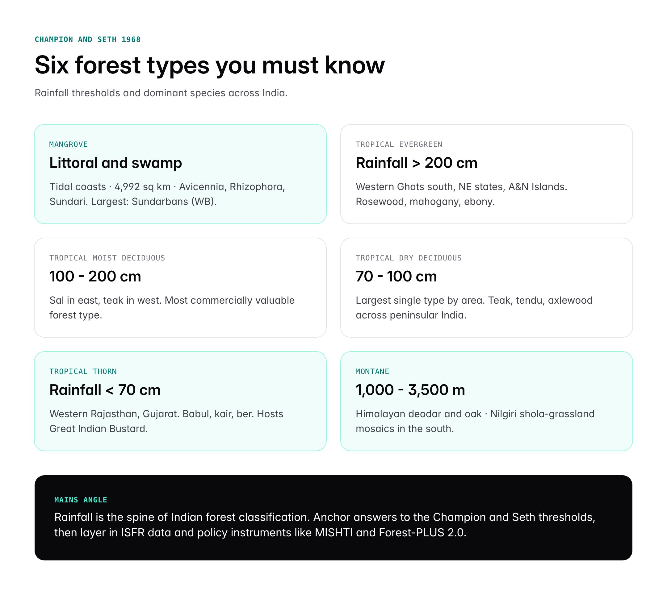
The Champion and Seth 1968 system
Champion and Seth group Indian forests into five major climatic types and 16 type groups. The five climatic groups are tropical, subtropical, temperate (montane), subalpine, and alpine. Each type group is further subdivided by composition and structure.
Tropical moist deciduous forests
Found where annual rainfall is 100 to 200 cm, chiefly in the foothills of the Himalayas, eastern slopes of the Western Ghats, Chhota Nagpur plateau, Odisha and parts of West Bengal. Teak dominates in the west, sal in the east. These are India’s most commercially valuable forests.
Tropical dry deciduous forests
The largest single forest type by area. Cover much of peninsular India where rainfall is 70 to 100 cm. Dominant species include teak, tendu, axlewood and Indian gooseberry.
Tropical thorn forests
Occur where rainfall is under 70 cm, mainly in southwestern Punjab, western Rajasthan, Haryana, Gujarat and the rain shadow of the Western Ghats in Andhra Pradesh, Karnataka and Madhya Pradesh. Dominant species are Acacia nilotica (babul), Prosopis juliflora (vilayati babul), Capparis decidua (kair), Zizyphus (ber) and Euphorbia. Trees are stunted, widely spaced and thorny. The ground is bare for most of the year and fills with short grasses in the monsoon. These forests are the least biomass-dense but support pastoral economies and species such as the chinkara, blackbuck and Great Indian Bustard.
Tropical evergreen and semi-evergreen forests
Occur where rainfall exceeds 200 cm, such as the Western Ghats south of Goa, the northeastern states and the Andaman and Nicobar Islands. Trees reach 60 metres, are multi-storeyed and yield rosewood, mahogany, ebony and aini.
Littoral and swamp forests (mangroves)
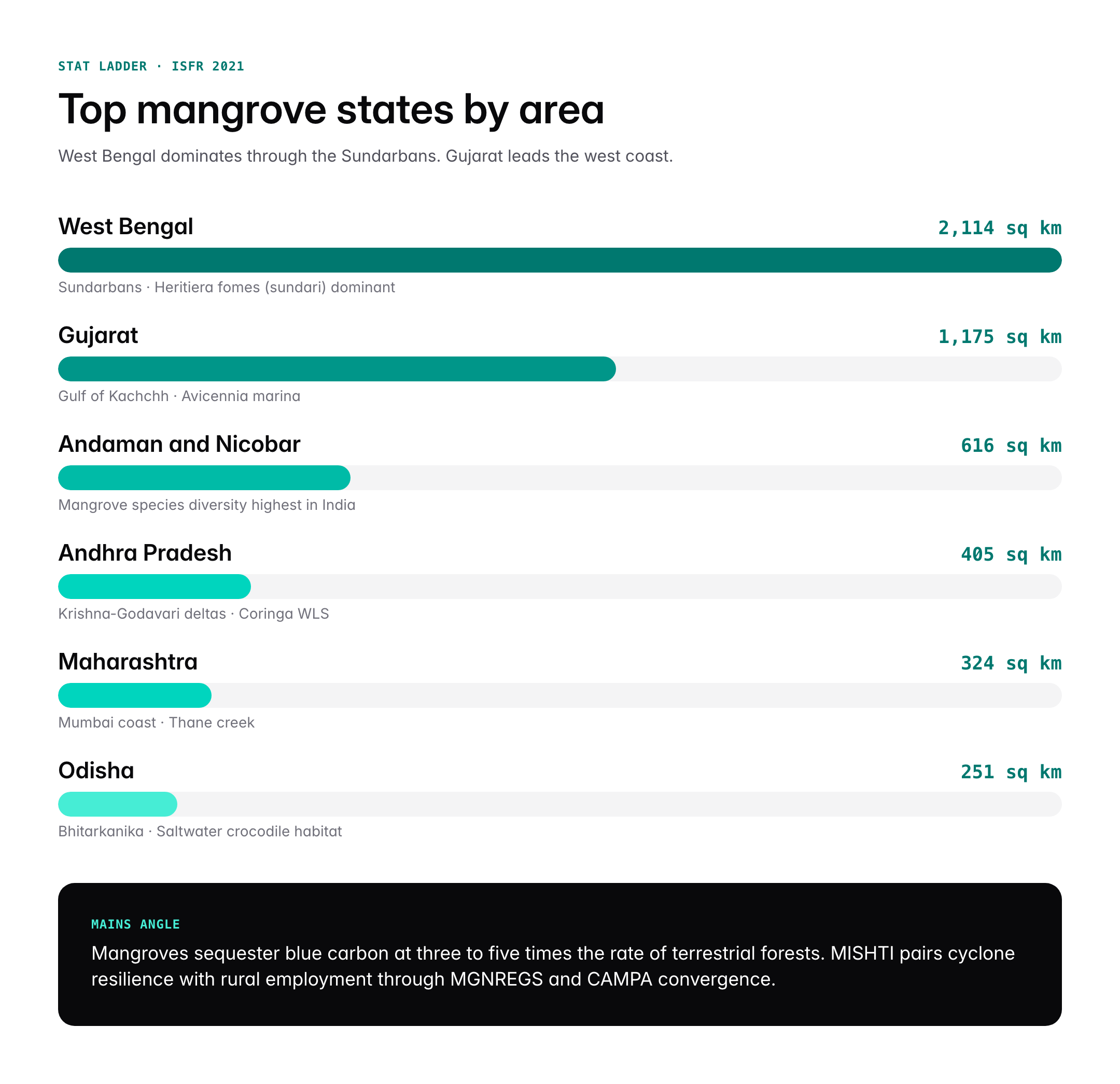
Mangrove forests occur in tidal zones along the coasts and deltas. India’s mangrove cover stands at 4,992 sq km in ISFR 2021, with the largest tract in the Sundarbans of West Bengal (2,114 sq km). Other significant mangrove areas include Bhitarkanika in Odisha, Godavari-Krishna deltas in Andhra Pradesh, Pichavaram in Tamil Nadu, and the Gulf of Kachchh in Gujarat. Avicennia, Rhizophora, Sonneratia and Heritiera fomes (sundari) are characteristic species. Mangroves protect coasts from cyclones and tsunamis, sequester blue carbon at rates three to five times higher than terrestrial forests, and nursery juvenile fish and crustaceans.
Montane forests
Montane forests are vertically zoned. In the Himalayas, they progress upward from tropical foothill forests through wet temperate (1,000 to 2,000 m), moist temperate (2,000 to 3,000 m), subalpine (3,000 to 3,500 m) and alpine meadows above the treeline. In the southern peninsula, the Nilgiris, Anamalais and Palnis host shola-grassland mosaics, where stunted evergreen shola patches occupy folds and depressions while grasslands cover exposed slopes. Characteristic species include oak, rhododendron, deodar (Cedrus deodara), silver fir, spruce and blue pine in the Himalayas, and Syzygium, Michelia and Ilex in the southern sholas.
Subalpine and alpine forests
Above 3,500 m in the Himalayas, silver fir and juniper give way to moist and dry alpine scrub and finally to alpine meadows dominated by grasses, sedges and cushion plants. These ecosystems are critical breeding grounds for ibex, snow leopard and Himalayan tahr.
Significance for UPSC and General Knowledge
- Classification questions based on Champion and Seth 1968 are a prelims staple.
- Mangrove questions appear in both prelims (species, Ramsar sites, state-wise cover) and mains (blue carbon, coastal resilience, MISHTI scheme).
- Montane forests connect to climate change vulnerability of Himalayan ecosystems, Western Ghats conservation and shola restoration debates.
- Tropical thorn forests underpin answers on desertification, the Aravalli degradation and Great Indian Bustard conservation.
- The importance of forests ties into NDC targets, carbon sinks and the 33 per cent national forest cover goal.
- Forest-PLUS 2.0 is a ready example of bilateral environmental cooperation for GS2 answers.
Detailed Analysis: State-wise Distribution and Schemes
Madhya Pradesh records the largest absolute forest cover at 77,493 sq km, followed by Arunachal Pradesh, Chhattisgarh, Odisha and Maharashtra. By percentage, Mizoram tops at 84.53 per cent, with Arunachal Pradesh, Meghalaya, Manipur and Nagaland also exceeding 70 per cent. The eight northeastern states together hold one-fourth of India’s forest cover on about eight per cent of the country’s land area, making this region the single most important repository of biodiversity in the country.
For mangroves, West Bengal’s 2,114 sq km is followed by Gujarat (1,175 sq km), Andaman and Nicobar Islands (616 sq km), Andhra Pradesh (405 sq km) and Maharashtra (324 sq km). The MISHTI scheme, or Mangrove Initiative for Shoreline Habitats and Tangible Incomes, announced in the Union Budget 2023-24, targets restoration and afforestation of mangroves along the coastline, with convergence through MGNREGS and the CAMPA fund. Afforestation and restoration feed India’s coastal climate resilience under the Intergovernmental Panel on Climate Change adaptation pathways.
The Forest-PLUS 2.0 programme is a five-year, USAID-supported initiative launched in December 2018, implemented in partnership with the Ministry of Environment, Forest and Climate Change. It works in three landscapes: Bikaner district in Rajasthan (dryland and tropical thorn ecosystem), Thiruvananthapuram in Kerala (tropical wet forest) and Medak district in Telangana (dry deciduous forest). The programme piloted ecosystem-based management, forest landscape restoration and valuation of non-timber forest produce as market-linked livelihoods.
Parallel initiatives include the Green India Mission under the National Action Plan on Climate Change, the CAMPA afforestation fund (which had a corpus of over Rs 54,000 crore devolved to states since 2019), the National Afforestation Programme and the Nagar Van scheme for urban forests. The Aravalli Green Wall Project announced in 2023 targets a 1,400 km green belt across Haryana, Rajasthan, Gujarat and Delhi to check desertification in the Thar periphery, drawing on tropical thorn forest species tolerant of arid conditions.
Comparative Perspective
India’s forest governance can be compared with regional peers on cover, change and policy ambition.
| Country | Forest cover (per cent) | Headline initiative |
|---|---|---|
| India | 21.71 | Green India Mission, Forest-PLUS 2.0, MISHTI |
| China | 23.4 | Three-North Shelterbelt, Grain for Green |
| Indonesia | 49.1 | Social Forestry, peatland restoration |
| Brazil | 59.0 | Amazon Fund, PPCDAm |
| Japan | 68.4 | Forest Act, satoyama landscape |
| USA | 33.9 | National Forest System, Farm Bill |
India is below the global average of about 31 per cent (FAO 2020) but has committed to raising forest and tree cover to 33 per cent of geographical area. Unlike Brazil, where primary forest loss dominates policy debate, India’s challenge is a mix of degradation within existing forests and slow regeneration in degraded landscapes, particularly the Aravalli and central Indian dry deciduous belt.
Challenges and Criticisms
Despite nominal gains in forest cover, several structural problems persist. First, ISFR counts any tree canopy above 10 per cent density as forest, including monoculture plantations, commercial orchards, coconut farms and bamboo thickets, which inflates headline numbers without translating to biodiversity outcomes. The Global Forest Watch database, which uses different definitions, reports steady annual tree-cover loss of around 2 to 3 lakh hectares in India.
Second, implementation of the Forest Rights Act 2006 remains uneven, and community forest resource rights are yet to be recognised across large parts of central India. Third, the 2023 amendment to the Forest (Conservation) Act has drawn criticism for narrowing the definition of forest to lands formally notified, potentially removing the Godavarman judgment protection for deemed forests identified by state expert committees. Fourth, compensatory afforestation under CAMPA has been criticised for plantation monocultures that do not replicate ecological function of diverted natural forests.
Mangroves face compounding pressures from aquaculture conversion, sea-level rise, reduced freshwater flow from upstream dams, and cyclonic damage. Tropical thorn forests lose area to both urbanisation (Aravalli near Delhi) and invasive Prosopis juliflora monocultures that suppress native diversity. Montane forests are vulnerable to changing precipitation patterns, glacier retreat, and tourism-linked land-use change.
Prelims Pointers
- ISFR 2021 records 21.71 per cent forest cover of India’s geographical area.
- Mangrove cover in India is 4,992 sq km (ISFR 2021).
- West Bengal has the largest mangrove area at 2,114 sq km.
- Sundari (Heritiera fomes) gives the Sundarbans its name.
- Madhya Pradesh has the largest absolute forest cover; Mizoram the largest percentage.
- Champion and Seth 1968 classify Indian forests into five climatic groups and 16 type groups.
- Tropical thorn forests occur where annual rainfall is under 70 cm.
- Shola-grassland mosaics are found in the Nilgiris, Anamalais and Palnis.
- Cedrus deodara dominates Himalayan moist temperate forests between 2,000 and 3,000 m.
- Forest-PLUS 2.0 operates in Bikaner, Thiruvananthapuram and Medak.
- MISHTI scheme was announced in Union Budget 2023-24.
- The 1988 National Forest Policy targets 33 per cent forest cover.
Mains Practice Questions
- Discuss the ecological and economic significance of mangrove forests in India. How does the MISHTI scheme complement existing coastal protection measures? (GS3, 15 marks, 250 words)
- Lay out blue-carbon, cyclone buffering and fisheries nursery functions with quantified benefits.
- Explain MISHTI’s convergence with MGNREGS and CAMPA, and state-level pilots.
- Add critique on aquaculture pressure and sea-level rise, concluding with reform direction.
- “India’s forest cover figures mask ecological decline.” Critically examine with reference to ISFR methodology and the 2023 amendments to the Forest (Conservation) Act. (GS3, 10 marks, 150 words)
- Unpack the canopy-density threshold issue and plantation inclusion.
- Contrast ISFR gains with Global Forest Watch loss data.
- Assess the narrowing of forest definition and its impact on deemed forests.
Conclusion
India’s forest estate is both a storehouse of biodiversity and a frontier of climate policy. The country hosts mangroves that buffer its 7,500 km coastline, montane forests that regulate the water towers of both the Himalayas and the peninsula, and tropical thorn forests that underwrite livelihoods in the driest districts. Understanding their classification, distribution and threats is not optional for an aspirant. It is the substrate on which current affairs questions on climate, biodiversity, schemes and bilateral cooperation are built.
The harder task, however, is to move beyond statistics to judgment. Forest cover is rising on paper, but very dense forest is growing only marginally while open forest expands. The difference matters ecologically and legally. Good mains answers acknowledge both the scale of state intervention and the honest gaps that remain in implementation, community rights recognition and ecological restoration quality.
Frequently Asked Questions
What is a mangrove forest in India?
A mangrove forest is a coastal tidal ecosystem of salt-tolerant trees and shrubs growing in brackish water along estuaries, deltas and sheltered coasts. India has 4,992 square kilometres of mangroves per ISFR 2021, with the Sundarbans in West Bengal the largest tract at 2,114 sq km. Other major areas include Bhitarkanika, Pichavaram, the Gulf of Kachchh and the Krishna-Godavari deltas.
Why are forests important for UPSC preparation?
Forests feed into GS3 environment, GS1 geography, GS2 bilateral cooperation and essay topics. UPSC routinely tests the Champion and Seth 1968 classification, ISFR data, state-wise distribution, schemes like MISHTI and Forest-PLUS 2.0, and policy instruments such as the Forest Rights Act 2006 and Forest Conservation Act 1980. Current affairs on mangroves, Aravalli restoration and carbon sinks also link here.
How is a montane forest different from a tropical thorn forest?
Montane forests occur in mountainous regions with altitude-driven vertical zonation, receive moderate to heavy rainfall, and include species like deodar, oak and shola. Tropical thorn forests occur in arid lowlands where rainfall is under 70 cm, feature stunted thorny trees like babul, kair and Prosopis, and support pastoral economies in western Rajasthan, Gujarat and the rain-shadow regions of peninsular India.
What is the total forest cover of India in 2026?
As of the most recent ISFR 2021 from the Forest Survey of India, total forest cover stands at 7,13,789 sq km or 21.71 per cent of the geographical area. Tree cover adds another 2.91 per cent, taking the combined figure to 24.62 per cent. The National Forest Policy target is 33 per cent, and India’s NDC targets an additional carbon sink of 2.5 to 3 billion tonnes CO2 equivalent by 2030.
What is Forest-PLUS 2.0?
Forest-PLUS 2.0 is a five-year bilateral programme between the Government of India and USAID launched in December 2018. It pilots landscape-level forest management in three sites: Bikaner in Rajasthan (dryland and tropical thorn), Thiruvananthapuram in Kerala (tropical wet forest) and Medak in Telangana (dry deciduous). It promotes ecosystem-based management, forest landscape restoration and market-linked non-timber forest produce livelihoods.
Which state has the highest forest cover in India?
In absolute terms, Madhya Pradesh has the largest forest cover at 77,493 sq km, followed by Arunachal Pradesh, Chhattisgarh, Odisha and Maharashtra. By percentage of geographical area, Mizoram leads at 84.53 per cent. The eight northeastern states together contain roughly one-fourth of India’s forest cover on about eight per cent of the country’s land area.
What are the main species in Indian tropical thorn forests?
Dominant species include Acacia nilotica (babul), Prosopis juliflora (vilayati babul), Capparis decidua (kair), Zizyphus (ber) and various Euphorbia species. Trees are stunted, widely spaced and thorny to reduce water loss. These forests support pastoral livelihoods and wildlife such as chinkara, blackbuck and the critically endangered Great Indian Bustard, particularly in the Thar periphery and Aravalli rain-shadow zones.
What is the MISHTI scheme for mangroves?
MISHTI stands for Mangrove Initiative for Shoreline Habitats and Tangible Incomes, announced in Union Budget 2023-24. It targets mangrove plantation and restoration along India’s coastline through convergence of MGNREGS, CAMPA and Compensatory Afforestation funds. The scheme complements existing coastal protection tools by pairing blue-carbon sequestration with local employment and cyclone resilience benefits in vulnerable coastal districts.