Coastal Regulation Zone (CRZ): Classification, 2019 Notification, and India’s Coastal Governance
A complete UPSC GS-III guide to the Coastal Regulation Zone in India. Covers the 2019 CRZ notification, four zones, NDZ rules, the Shailesh Nayak Committee, key permitted and prohibited activities, and the policy debates around fisherfolk livelihoods and coastal development.
The Coastal Regulation Zone, or CRZ, is the rulebook that decides what you can and cannot build along India’s 7,500-kilometer coastline. It is issued by the Ministry of Environment, Forest and Climate Change under the Environment (Protection) Act, 1986, and it has been rewritten three times since 1991 because the same coastline has to serve fisherfolk, tourists, port operators, defense planners, and a fragile ecosystem of mangroves, coral reefs, and turtle nesting beaches.
For the UPSC aspirant, CRZ sits at the intersection of GS-III environment, GS-II governance, and the long-running policy argument about whether ecological caution and economic growth can coexist on the same stretch of sand. The 2019 notification, drafted on the recommendations of the Shailesh Nayak Committee, is the version currently in force, and most prelims questions on coastal regulation now point back to its four-zone classification.
Quick Facts on the Coastal Regulation Zone
The CRZ is the legal envelope around the Indian coast in which human activity is regulated to protect the ecosystem and the livelihoods that depend on it. The current rules are notified under Section 3 of the Environment (Protection) Act, 1986, which gives the Centre the power to lay down standards for environmental quality and to restrict activities in identified areas.
The nodal ministry is the Ministry of Environment, Forest and Climate Change, and enforcement on the ground rests with the Coastal Zone Management Authorities at the central, state, and union territory levels. The 2019 notification replaced the 2011 notification, which had itself replaced the original 1991 framework.
What the CRZ Actually Is
Think of the CRZ as a buffer zone running along the entire Indian coast and along tidal water bodies that connect to the sea. It begins at the High Tide Line, the highest water level reached during a spring tide, and extends inland for a distance that depends on the type of coast you are looking at. It also extends seaward up to twelve nautical miles, which means the rules cover not just the beach but the near-shore marine area too.
Background and Historical Context
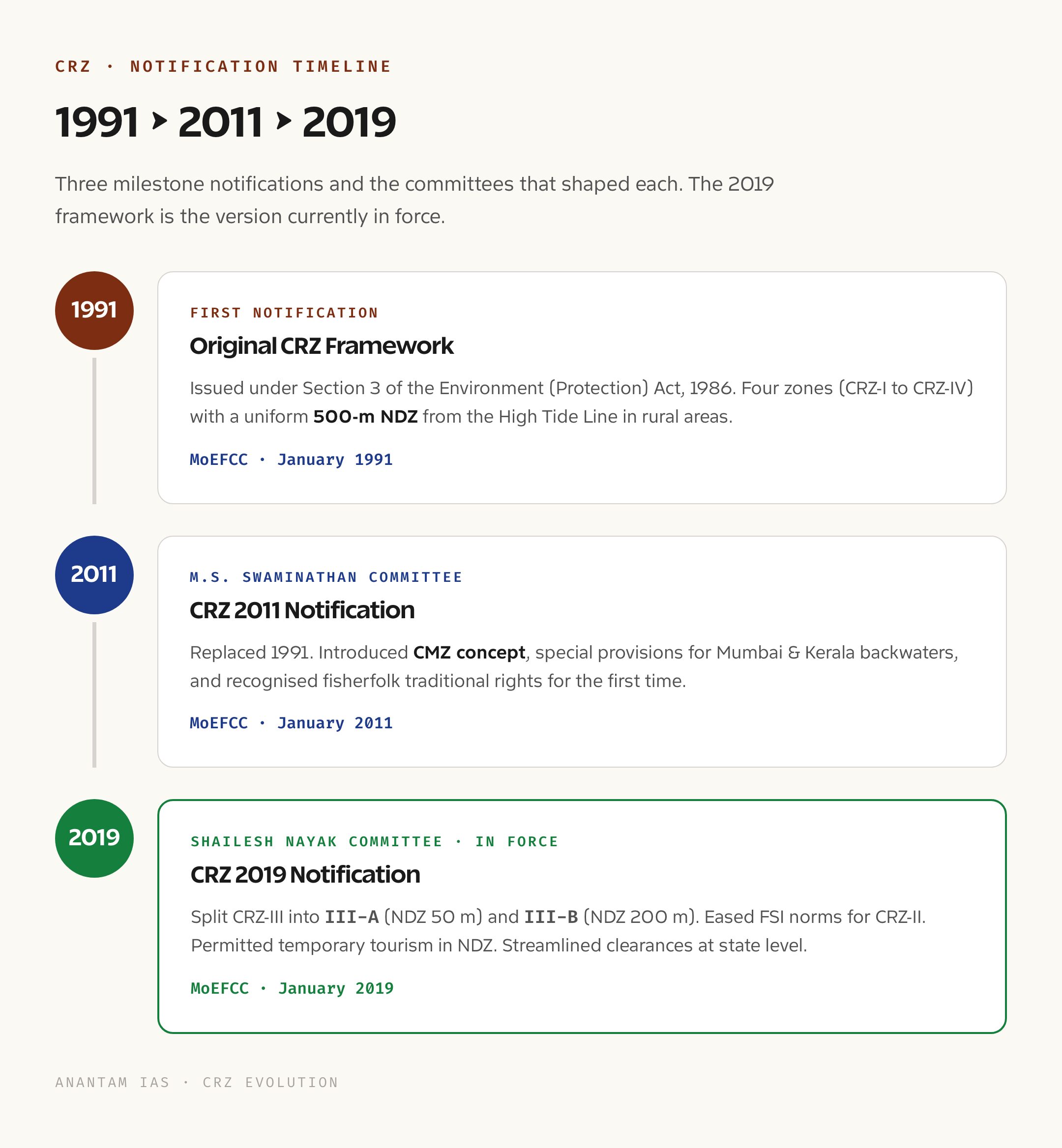
India’s first coastal regulation came in February 1991, when the Centre issued a notification declaring the entire stretch of land influenced by tidal action a Coastal Regulation Zone. The 1991 framework drew a 500-meter no-construction line measured from the High Tide Line and split the zone into four categories. It was a cautious, almost defensive document, written in the years immediately after the Bhopal disaster when the Environment (Protection) Act was still being tested.
Over the next two decades, complaints piled up. Fisherfolk argued that the rules treated their traditional villages the same as luxury resorts. State governments said the uniform 500-meter setback ignored the fact that Mumbai and a remote Lakshadweep atoll are not the same kind of coast. Tourism operators wanted clarity on what counted as development. The 2011 notification tried to address these gaps by introducing a separate category for islands and by relaxing some restrictions for slum redevelopment in Mumbai, but it added fresh confusion of its own.
In 2014 the government set up an expert committee under Dr. Shailesh Nayak, a former Secretary of the Ministry of Earth Sciences, to review the entire framework. The committee submitted its report in 2015, and after four years of consultation the recommendations were folded into the environmental laws in India regime through the January 2019 notification. The 2019 rules are the version a UPSC candidate has to know in detail.
Key Provisions of the 2019 Notification
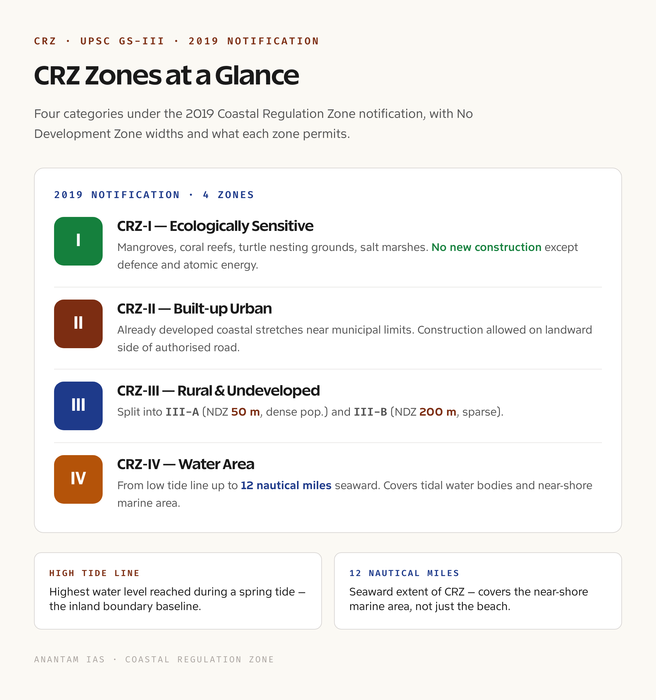
The 2019 notification keeps the four-zone structure but redraws the inner boundaries with much finer detail. CRZ-I now has two sub-zones. CRZ-I A covers ecologically sensitive areas, the kind of places where construction is essentially banned. The list includes mangroves, coral reefs, sand dunes, biologically active mudflats, salt marshes, turtle nesting grounds, and areas falling within national parks or marine sanctuaries. Where mangrove patches are larger than 1,000 square meters, a 50-meter buffer is added around them.
CRZ-I B is the inter-tidal zone, the strip between the Low Tide Line and the High Tide Line that floods and drains with every tide. New land reclamation is barred here except for strategic and environmental projects. CRZ-II covers urban developed coastal areas, the substantially built-up stretches of municipalities like Mumbai, Chennai, Kochi, and Visakhapatnam. Construction is permitted on the landward side of existing roads or authorized structures.
CRZ-III is the rural belt and is now split based on population density measured in the 2011 Census. CRZ-III A is densely populated rural coast, defined as having more than 2,161 people per square kilometer. Here the no-development zone shrinks from the earlier 200 meters to 50 meters from the High Tide Line. CRZ-III B is the sparsely populated rural coast, where the strict 200-meter NDZ continues. CRZ-IV covers the water area itself, with CRZ-IV A running from the Low Tide Line to twelve nautical miles seaward, and CRZ-IV B covering tidal-influenced inland water bodies like creeks, estuaries, and backwaters where salinity exceeds 5 parts per thousand.
Why the CRZ Matters
The Indian coastline supports more than 250 million people directly or indirectly, including the country’s entire marine fisheries economy. Mangroves along the eastern and western coasts act as natural sea walls. The 1999 Odisha super cyclone and the 2004 Indian Ocean tsunami both showed that villages behind dense mangrove cover suffered far less damage than those without. Coral reefs in the Gulf of Mannar, Andaman waters, and Lakshadweep are biodiversity hotspots that are also extremely vulnerable to sediment runoff from coastal construction.
Beyond ecology, the CRZ is a livelihood document. Traditional fishing rights, salt pan operations, and small-scale agriculture in coastal villages all depend on the rules getting the balance right between protection and access. When the 2019 notification was issued, the Centre framed it as a way of giving rural coastal residents more space to expand their homes while keeping the strictest protections for genuinely sensitive zones.
Detailed Analysis of the Four Zones
Looking at the zones together rather than as separate boxes makes the logic clearer. CRZ-I represents zero-tolerance protection, the parts of the coast that the framework treats as off-limits to anything other than essential public infrastructure or activities directly tied to environmental conservation, such as sea wall construction or mangrove restoration. Even within CRZ-I, the inter-tidal zone is treated slightly differently because it is naturally dynamic and any structure built there will be exposed to wave action.
CRZ-II, the urban zone, is the most permissive in practice. Cities cannot be unbuilt, and the framework recognizes that. New construction has to follow the local town and country planning rules, and it cannot intrude seaward of existing authorized structures. The rule is essentially a freeze on coastal expansion: cities can densify behind the existing line but cannot push further into the sea.
CRZ-III is where the 2019 notification made its biggest political statement. By introducing a population-density split, the rules acknowledged that coastal villages are not a single uniform category. Densely populated rural areas, which are often clusters of fisherfolk settlements, get a relaxed 50-meter NDZ, which lets families expand homes and add basic amenities. Sparsely populated rural areas keep the strict 200-meter buffer.
CRZ-IV is the water body zone and is mostly about pollution prevention. Discharge of untreated effluents from coastal industries, dumping of construction debris, and unregulated dredging are all controlled here. Traditional fishing and related activities are explicitly protected.
Comparative View: 1991 vs 2011 vs 2019
The 1991 notification operated on a simple logic of distance from the sea. The 2011 notification added complexity by carving out island regulations, recognizing hazardous fishing villages, and creating the CRZ-IV category for water bodies. The 2019 notification refines this further by dividing CRZ-I and CRZ-III into sub-zones and by replacing the uniform NDZ with a graded one.
The other major shift across the three versions is procedural. The 1991 framework concentrated approvals at the central level. The 2011 notification began devolving certain approvals to state Coastal Zone Management Authorities. The 2019 notification continues this trend by transferring many CRZ-II project approvals to the state level, retaining only CRZ-I and CRZ-IV approvals at the Ministry of Environment, Forest and Climate Change.
Challenges and Criticisms
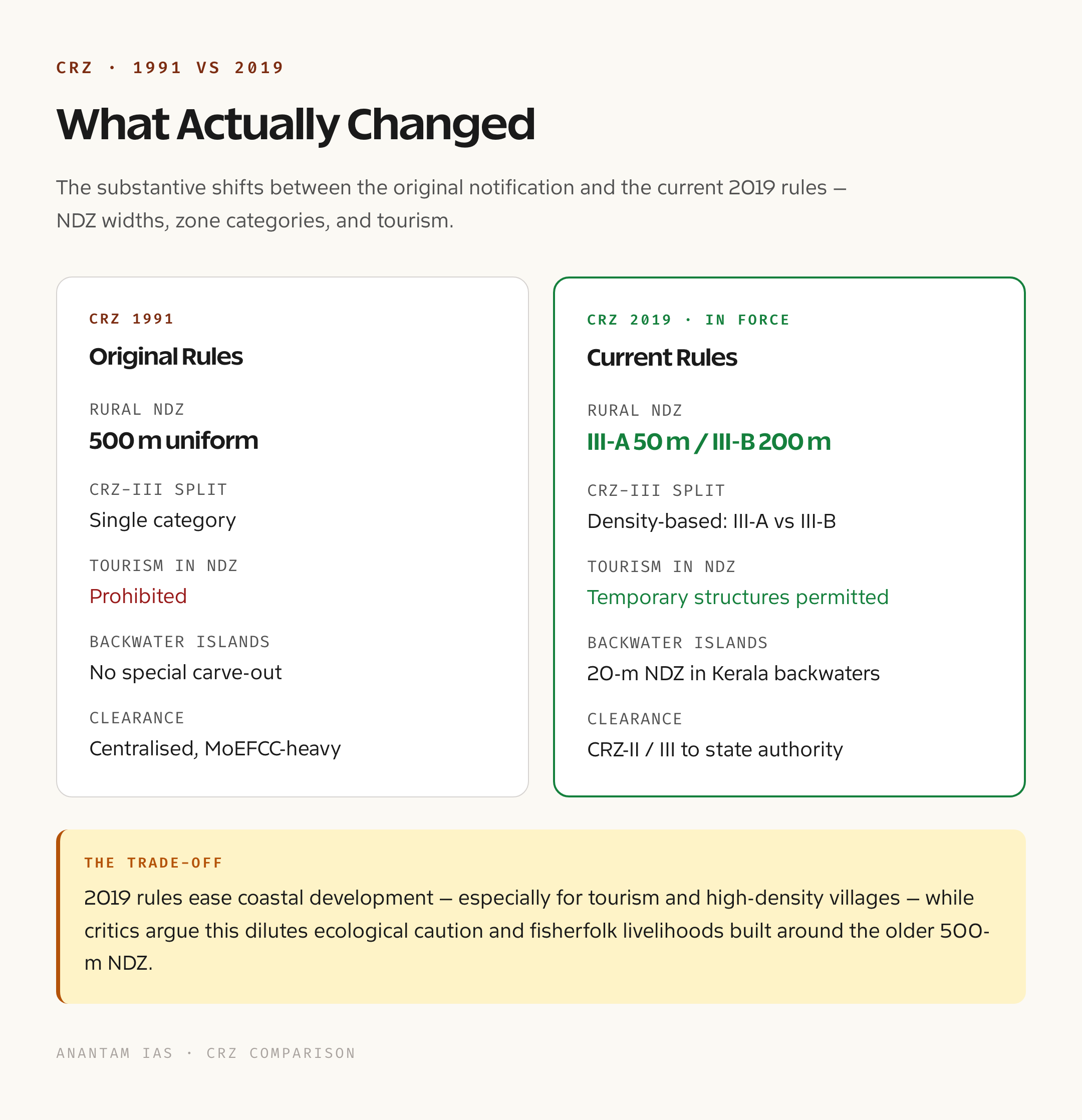
Critics argue that the 2019 notification effectively dilutes coastal protection. The reduction of the rural NDZ in densely populated areas from 200 to 50 meters has been called a tourism-friendly amendment by some environmental groups, who fear it will be used to clear the way for resorts in fishing villages that will then be reclassified. The shift of more approvals to state authorities is also seen as risky in coastal states with weak enforcement records.
Climate change adds another layer of complexity. Sea-level rise is already eroding stretches of the eastern coast, and the High Tide Line that anchors the entire CRZ framework is itself moving inland. The notification does not yet have a clear protocol for periodically updating the HTL maps to reflect this. Cyclone intensification is making the 50-meter NDZ in densely populated rural zones look thin.
Implementation gaps are the third weakness. Coastal Zone Management Plans are supposed to be prepared and notified by every coastal state and union territory, but several have missed deadlines, leaving large stretches of coast effectively without zone-specific plans. Without a notified plan, the default rules apply, which often hurt local communities the most because they cannot prove their traditional rights without a map.
Prelims Pointers on CRZ
The 2019 notification is issued under the Environment (Protection) Act, 1986, and the nodal ministry is the Ministry of Environment, Forest and Climate Change. The Shailesh Nayak Committee submitted its report in 2015. The four zones are CRZ-I, CRZ-II, CRZ-III, and CRZ-IV, with sub-zones in I, III, and IV. The High Tide Line is the highest water level during a spring tide, while the Low Tide Line is the lowest. The seaward limit of CRZ-IV A is twelve nautical miles. The population density threshold for CRZ-III A is 2,161 per square kilometer using Census 2011 data. Mangrove buffer zones of 50 meters apply where mangrove patches exceed 1,000 square meters.
For a fuller picture of how this fits with other ecosystem protections, candidates should also look at the mangrove ecosystem in India and the biodiversity in India framework, both of which intersect with CRZ-I provisions.
Mains-Level Questions
A standard mains question on this topic might ask whether the 2019 CRZ notification strikes the right balance between coastal development and ecosystem protection. A good answer would walk through the zone-by-zone changes, link the population-density split in CRZ-III to fisherfolk livelihoods, examine the reduction in central approvals as a federalism question, and end with the climate-resilience gap.
Another common framing asks about the role of community participation in coastal management. Here candidates can bring in the Coastal Zone Management Plans process, point out the weak link between gram sabha approvals and CRZ enforcement, and refer to comparable participatory frameworks like the Forest Rights Act 2006 for context.
Way Forward
A robust CRZ regime needs three things going forward. First, dynamic mapping. The HTL must be updated on a fixed cycle, ideally every five years, using satellite-based shoreline change data, so that the zones reflect actual coastal positions rather than historical ones. Second, climate integration. Sea-level rise projections should be built into NDZ widths in vulnerable stretches, with stricter buffers in areas of accelerated erosion. Third, livelihood security. The framework should treat traditional fisherfolk as primary stakeholders, with their rights mapped, recognized, and protected before any new commercial project is cleared.
There is also a strong case for harmonizing the CRZ with the broader wetlands of India regime, since estuaries and coastal lagoons fall under both regimes simultaneously, often with conflicting rules. A unified coastal and wetland code would make compliance simpler for state agencies and for project proponents alike.
Frequently Asked Questions
What is the Coastal Regulation Zone?
The Coastal Regulation Zone is a notified buffer along India’s coast and tidal water bodies in which construction and industrial activity are regulated. It is issued by the Ministry of Environment, Forest and Climate Change under the Environment (Protection) Act, 1986.
When was the latest CRZ notification issued?
The current notification was issued in January 2019 and replaced the 2011 notification. It is based on the recommendations of the Shailesh Nayak Committee, which submitted its report in 2015.
What is the difference between CRZ-III A and CRZ-III B?
Both fall in the rural coastal category. CRZ-III A covers densely populated rural areas with more than 2,161 people per square kilometer based on Census 2011, with a relaxed 50-meter no-development zone. CRZ-III B covers sparsely populated rural areas with a strict 200-meter no-development zone.
Who recommended the 2019 reforms?
The 2019 reforms were drafted on the basis of the Shailesh Nayak Committee report submitted in 2015. Dr. Shailesh Nayak was previously Secretary of the Ministry of Earth Sciences.
What is the High Tide Line?
The High Tide Line is the line up to which the highest water level reaches during a spring tide. It is the landward anchor for the entire CRZ framework and is mapped by authorized agencies for each stretch of coast.
Are traditional fishing activities allowed in CRZ areas?
Yes. Traditional fishing and allied activities are explicitly permitted across all CRZ categories. The 2019 notification recognizes fisherfolk communities and their livelihoods as a protected category and allows the construction of facilities required for traditional fishing operations.
What is the seaward extent of the CRZ?
The seaward extent is twelve nautical miles from the Low Tide Line, which corresponds to India’s territorial waters under the Law of the Sea. This is covered by CRZ-IV A.
Why is mangrove protection given a separate buffer?
Mangroves are coastal forests that act as natural breakwaters, fish nurseries, and carbon sinks. Where mangrove patches exceed 1,000 square meters, the 2019 notification adds a 50-meter buffer around them within CRZ-I A to keep adjacent construction from damaging the root systems and tidal exchange.
How are CRZ violations handled?
Violations are handled by the State Coastal Zone Management Authorities and can attract penalties under the Environment (Protection) Act, 1986. Persistent violations can be referred to the National Green Tribunal, which has decided several high-profile coastal demolition cases.
Does the CRZ apply to all union territories?
Yes. The CRZ applies to all coastal states and union territories, including Lakshadweep and the Andaman and Nicobar Islands, which have additional island-specific provisions under a separate Island Protection Zone notification issued alongside the CRZ.