When Cyclone Amphan struck the Bay of Bengal in May 2020 with wind speeds of 185 km/h, satellite imagery later revealed something striking: villages behind dense mangrove cover suffered far less damage than those behind degraded or cleared mangroves. The Sundarbans absorbed the worst of the storm before it crashed into Kolkata. A single hectare of healthy mangrove can protect roughly 80 metres of coastline from storm surge.
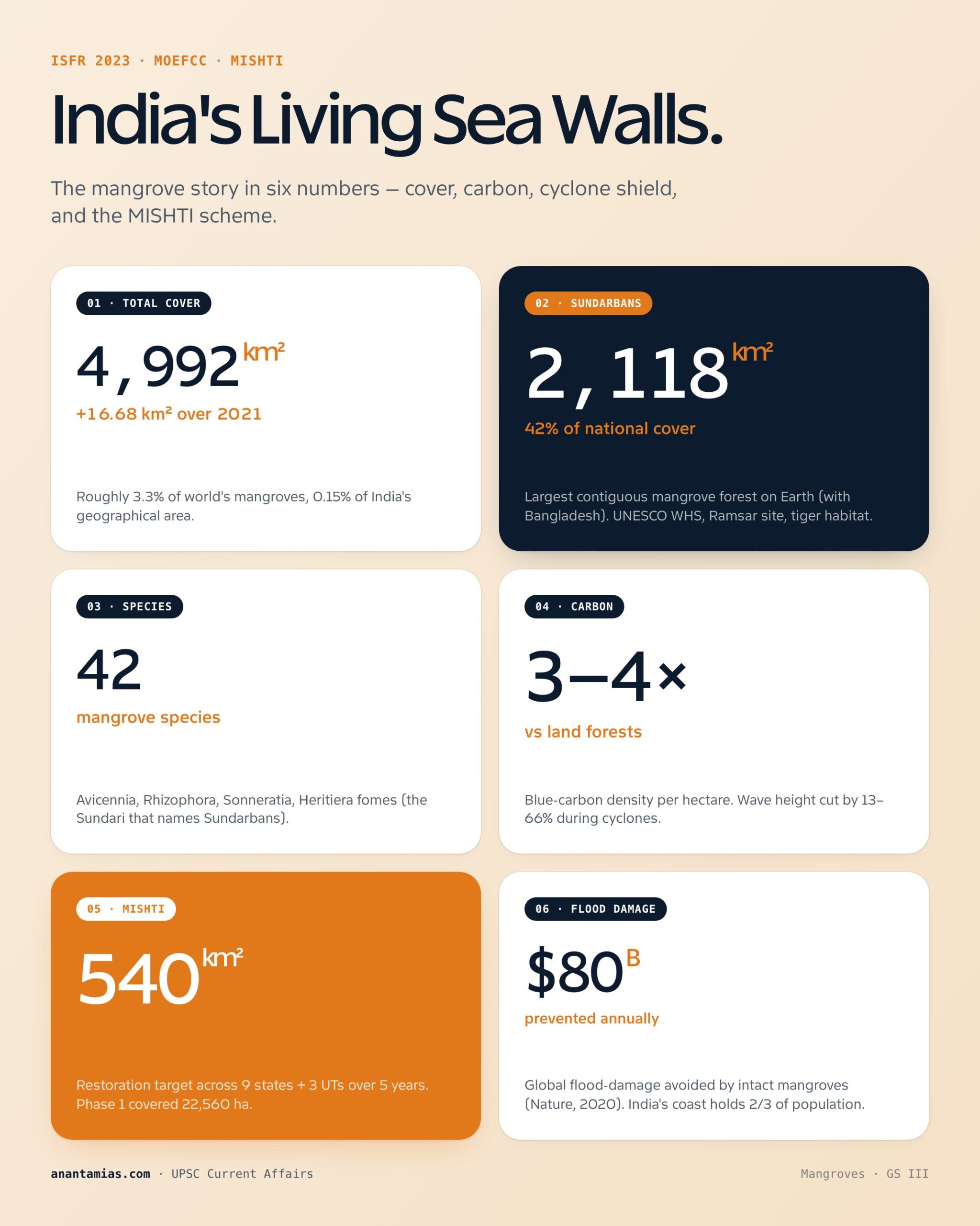
Mangroves are not just plants. They are engineered ecosystems — natural sea walls, carbon vaults, fish nurseries and biodiversity hotspots, all in one. India hosts roughly 4,992 sq km of mangrove cover (ISFR 2023), about 3.3% of the world's total and 0.15% of India's geographical area. Their conservation is now anchored by the MISHTI scheme announced in Budget 2023.
This guide explains what mangroves are, how they survive saltwater, the threats they face, India's distribution and policy framework, and the latest 2024–26 developments.
What are Mangroves?
Mangroves are salt-tolerant trees and shrubs (halophytes) that grow in tropical and subtropical intertidal zones — the band of coast between high and low tide. They thrive in:
- Rainfall: 1,000–3,000 mm annually.
- Temperature: 26–35°C.
- Salinity: brackish to marine waters.
- Coastline type: estuaries, deltas, lagoons, sheltered bays.
The word "mangrove" can refer to the plant species (~80 globally) or the ecosystem (mangal). India has roughly 42 mangrove species including Avicennia, Rhizophora, Sonneratia, Bruguiera, Heritiera (the famed Sundari of the Sundarbans).
Halophyte Adaptations
Mangroves have evolved striking adaptations to survive in salt water and waterlogged, oxygen-poor mud:
- Pneumatophores (breathing roots) — pencil-like aerial roots that emerge from the mud to take in oxygen (e.g., Avicennia).
- Stilt roots / prop roots — anchor the tree in soft mud and trap sediment (Rhizophora).
- Salt secretion glands — excrete excess salt through leaves; salt crystals visible on the underside.
- Salt exclusion at roots — selective ion transport prevents most salt from entering the plant.
- Vivipary — seeds germinate while still attached to the parent tree, producing a "propagule" that drops into the water and floats to a new site.
- Thick waxy leaves — reduce water loss in the saline environment.
Ecological and Economic Significance
| Service | Value |
|---|---|
| Coastal protection | Reduces wave height by 13-66%; saves lives during cyclones |
| Carbon sequestration | "Blue carbon" — store 3-4x more carbon per hectare than terrestrial forests |
| Fish nurseries | Spawning ground for 75% of commercially valuable tropical fish |
| Biodiversity | Habitat for tigers (Sundarbans), saltwater crocodiles, dolphins, migratory birds |
| Livelihoods | Honey, fish, crab, tannin, fuelwood for coastal communities |
| Erosion control | Trap sediment, build land, stabilise coastlines |
| Water quality | Filter pollutants and excess nutrients |
A 2020 Nature study estimated that mangroves prevent over $80 billion in flood damage globally each year.
Threats to Mangroves
Land-Use Conversion
The biggest single driver. Mangroves are cleared for:
- Aquaculture — particularly shrimp farming. Andhra Pradesh and Tamil Nadu coasts saw massive losses in the 1990s-2000s.
- Urban expansion and tourism — Mumbai, Goa, Kerala backwaters.
- Agriculture — paddy and salt farms.
- Industry and ports — petrochemical complexes, SEZs.
Globally, 35% of mangroves were lost between 1980 and 2000. The rate has slowed but is still ~0.4% annually in South Asia.
Overharvesting
Firewood, charcoal, construction timber, fodder, tannin extraction.
Damming and Reduced Freshwater Flow
Dams and irrigation projects upstream restrict freshwater discharge into estuaries. Increased salinity stresses mangroves; Sundari (Heritiera fomes) decline in the Sundarbans is partly attributed to Farakka Barrage effects.
Sediment Loading and Clogging
Excess sediment from deforested catchments smothers mangrove pneumatophores and clogs estuary mouths.
Overfishing and Coral Reef Loss
Coral reefs offshore are mangroves' first line of defence against waves. When reefs degrade, stronger waves erode mangrove roots. Overfishing also disrupts the food chains that mangroves anchor.
Pollution
- Agricultural runoff — fertilisers cause eutrophication.
- Pesticides — reduce invertebrate populations.
- Industrial effluent and oil spills — coat pneumatophores, suffocate trees. The 1991 Gulf War oil spill devastated Persian Gulf mangroves.
Climate Change
- Sea-level rise — mangroves can keep pace only if they have landward room to migrate and sediment supply. Coastal infrastructure blocks both.
- Cyclone intensification — more frequent severe storms damage mature mangroves faster than they regenerate.
- Temperature shifts — affect propagule dispersal and species composition.
India's Mangrove Distribution
| Region | Cover (2023, sq km) | Share | Key features |
|---|---|---|---|
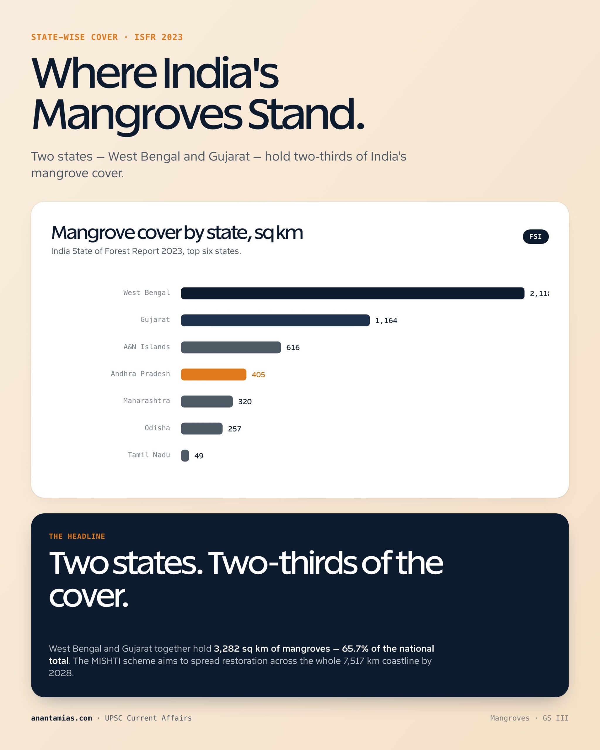
| West Bengal (Sundarbans) | 2,118 | 42% | Largest contiguous mangrove forest in the world (with Bangladesh); UNESCO WHS; Royal Bengal tiger habitat |
| Gujarat (Gulf of Kachchh, Kori Creek) | 1,164 | 23% | Second largest; arid mangroves |
| Andaman & Nicobar Islands | 616 | 12% | Pristine; 38 species |
| Andhra Pradesh (Coringa, Krishna) | 405 | 8% | Coringa Sanctuary |
| Maharashtra (Thane Creek) | 320 | 6% | Mumbai's green lung; Ramsar site |
| Odisha (Bhitarkanika) | 257 | 5% | Saltwater crocodiles; olive ridley nesting nearby |
| Tamil Nadu (Pichavaram, Muthupet) | 49 | 1% | Tourism, fish nurseries |
| Kerala | 9 | <1% | Vembanad backwaters |
| Goa, Karnataka, Daman, Puducherry | <50 | <1% | Fragmented |
| Total India (ISFR 2023) | 4,992 | 100% | — |
The Indian State of Forest Report 2023 noted a small net increase of 16.68 sq km over 2021, mostly from West Bengal, Gujarat and Andhra Pradesh restoration.
India's Conservation Framework
Coastal Regulation Zone (CRZ) Notification
- CRZ-IA is the strictest category — covers mangroves and a 50-metre buffer; almost no development allowed.
- CRZ-2019 further tightened rules and gave mangrove panchayat-level mapping.
Wildlife Protection Act, 1972
- Sundarbans, Bhitarkanika, Coringa and other mangrove sanctuaries are notified as National Parks or Wildlife Sanctuaries.
Forest Conservation Act, 1980
- Diversion of mangrove forest land to non-forest use requires central approval.
National Coastal Mission (Climate Change)
- Mangrove restoration is a core activity; supported by funds under National Action Plan on Climate Change.
MISHTI — Mangrove Initiative for Shoreline Habitats and Tangible Incomes
- Announced in Union Budget 2023-24.
- Implemented by MoEFCC in convergence with MGNREGS, CAMPA Fund and other schemes.
- Target: restore mangroves across 540 sq km in 9 states and 3 UTs over 5 years.
- Approach: planting + community-led management + livelihood support.
- States covered: Gujarat, Maharashtra, Goa, Karnataka, Kerala, Tamil Nadu, Andhra Pradesh, Odisha, West Bengal + A&N, Daman, Puducherry.
National Committee on Wetlands, Mangroves and Coral Reefs
- Apex advisory body under MoEFCC.
State-Level Mangrove Cells
- Maharashtra Mangrove Cell (2012) — model for other states.
- Gujarat Ecology Commission — mangrove afforestation in Kachchh.
- West Bengal Sundarbans Affairs Department — dedicated department.
Ramsar Convention
India has 89 Ramsar sites (2024). Mangrove-rich Ramsar sites include Sundarban Wetland, Bhitarkanika, Coringa, Thane Creek, Pichavaram.
International Frameworks
- Mangrove Alliance for Climate (MAC) — launched at COP27 (Egypt 2022) by UAE and Indonesia; India joined in 2023.
- Global Mangrove Alliance — IUCN-led platform with 30% by 2030 mangrove restoration target.
- Ramsar Convention on Wetlands — covers mangrove wetlands.
- CBD Kunming-Montreal GBF (2022) — Target 2 (restore 30% of degraded ecosystems) explicitly includes mangroves.
- Blue Carbon Initiative — Conservation International, IOC-UNESCO, IUCN.
Recent Developments (2024–26)
- MISHTI scheme — first phase (2023-24) restored over 22,560 hectares across 13 states; phase 2 underway.
- ISFR 2023 — net mangrove cover increase of 16.68 sq km over 2021; West Bengal, Gujarat, Andhra Pradesh leading.
- Mangrove Alliance for Climate — India hosted side event at COP28 (UAE 2023) and COP29 (Baku 2024).
- International Day for Conservation of the Mangrove Ecosystem — celebrated 26 July annually.
- Cyclone Remal (May 2024) — struck Sundarbans; revealed continued vulnerability and reinforced restoration urgency.
- Sundarbans-specific Mangrove Plan announced by West Bengal government (2024) for 100 sq km restoration over 3 years.
- Blue carbon markets — India's first mangrove blue-carbon project notified in Maharashtra (Thane Creek) under VCS, 2024.
- Kachchh mangrove restoration — 1,000 hectare project funded by Adani Foundation as part of CSR + biodiversity offset, 2024.
- Sundarbans tiger census 2024 — population stable at 100+ tigers despite habitat pressures.
- Plastic pollution in Indian mangroves documented at high levels in NCCR 2024 study; Mumbai's Thane Creek shows highest microplastic load.
Way Forward
- Scale up MISHTI with science-based site selection (avoid mudflats and seagrass beds).
- Community-led restoration with secure land tenure and livelihood incentives.
- Mangrove buffer zones in all coastal master plans — minimum 100 m landward of mangrove edge.
- Strengthen CRZ enforcement — penalise illegal aquaculture and reclamation.
- Blue carbon registry for verified mangrove carbon credits with social safeguards.
- Integrate mangroves into Climate Adaptation Plans of coastal districts.
- Stop dam-induced freshwater starvation — environmental flow mandates for major rivers.
- Plastic and pollution control in mangrove zones with extended producer responsibility.
- Trans-boundary cooperation with Bangladesh on Sundarbans management.
- Mangrove tourism with regulation — boardwalks, no-go zones, visitor caps.
- Insurance for mangrove projects — climate-resilient bonds, green sukuks.
Mains Hook
"Mangroves are India's natural sea walls in the era of climate change. Discuss their ecological significance and evaluate the MISHTI scheme." — GS III
"The Sundarbans is a living laboratory for climate adaptation. Examine the threats to its mangrove ecosystem and suggest a multi-pronged conservation strategy." — GS III
Prelims Pointers
- Mangroves are halophytes (salt-tolerant plants).
- Grow in tropical/subtropical intertidal zones with rainfall 1,000-3,000 mm and temp 26-35°C.
- Adaptations: pneumatophores, stilt roots, salt glands, vivipary, propagules.
- India's mangrove cover: 4,992 sq km (ISFR 2023) — ~3.3% of world total.
- Largest mangrove area in India: Sundarbans (West Bengal) — 2,118 sq km.
- Sundarbans is a UNESCO World Heritage Site and a Ramsar site.
- Heritiera fomes (Sundari) gives Sundarbans its name.
- Bhitarkanika (Odisha) — saltwater crocodile habitat.
- MISHTI scheme — Budget 2023-24; target ~540 sq km over 5 years.
- Mangrove Alliance for Climate — launched COP27 (2022); India joined 2023.
- CRZ-IA is the strictest category; covers mangroves.
- International Mangrove Day: 26 July.
- Mangroves store 3-4x more carbon per hectare than terrestrial forests.
- Maharashtra has India's first dedicated Mangrove Cell (2012).
- Ramsar mangrove sites in India: Sundarban Wetland, Bhitarkanika, Coringa, Thane Creek, Pichavaram.
Conclusion
Mangroves are the only ecosystem on Earth that simultaneously locks away carbon, protects coastlines from cyclones, supports fisheries, and shelters tigers. They cost almost nothing to plant and a fortune to lose. India's MISHTI scheme is a real start — but it must be scaled, science-led, and rooted in coastal communities to truly outpace land conversion, sea-level rise and pollution. In a country where two-thirds of the population lives within 200 km of a coast, the mangrove is not an environmental nicety. It is climate insurance.
Tell Google you want more of this.
Add Anantam IAS as a preferred sourceOne tap, and this site shows up more often in your own Top Stories, AI Overviews and AI Mode. Remove it any time.